Showing 30439 items
matching a. hill
-
 Whitehorse Historical Society Inc.
Article, Box Hill keen to retain its existing boundaries, 1986
Article about discussions over Box Hill and Nunawading boundaries.Article about discussions over Box Hill and Nunawading boundaries.Article about discussions over Box Hill and Nunawading boundaries.local government, city of box hill, city of nunawading, amalgamations -
 Whitehorse Historical Society Inc.
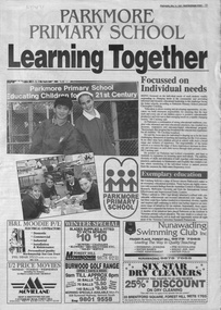
Newspaper - Article, Parkmore Primary School, 14/05/1997
Article on Parkmore Primary School, Jolimont Road, Forest Hillparkmore primary school, no. 4881, primary schools -
Whitehorse Historical Society Inc.
Article, City to have resource centre, 1992
A resource centre to be established by City of Nunawading at Forest Hill Chase.A resource centre to be established by City of Nunawading at Forest Hill Chase.A resource centre to be established by City of Nunawading at Forest Hill Chase.city of nunawading, resource centres, forest hill chase, edwards, margaret -
Whitehorse Historical Society Inc.
Book, Forest Hill Progress Association, 1949 - 1965
Forest Hill Progress Association -Forest Hill Progress Association - Treasurer's book, 1949 - 1965Forest Hill Progress Association - clubs and associations, forest hill progress association -
Whitehorse Historical Society Inc.
Article, National Bus Service, 2/09/1994 12:00:00 AM
Bus Service boost Nunawading, Box Hill, Doncaster and RingwoodBus Service boost Nunawading, Box Hill, Doncaster and RingwoodBus Service boost Nunawading, Box Hill, Doncaster and Ringwoodbus services, national bus company -
Whitehorse Historical Society Inc.
Book, St Mark's at Forest Hill, 1/08/1988 12:00:00 AM
A History of the Anglican Church of St Mark the Evangelist at Forest Hill.A History of the Anglican Church of St Mark the Evangelist at Forest Hill.A History of the Anglican Church of St Mark the Evangelist at Forest Hill.st marks anglican church, forest hill -
Whitehorse Historical Society Inc.
Article, Closure of store to cost more jobs, 1992
Closure of Venture Store at Forest Hill Chase shopping centre.Closure of Venture Store at Forest Hill Chase shopping centre.Closure of Venture Store at Forest Hill Chase shopping centre.forest hill chase, venture stores -
Whitehorse Historical Society Inc.
Article, Box Hill Pictures
Weekly picture show at Box Hill's Recreation Hall. Photocopyfilms, box hill recreation hall -
Whitehorse Historical Society Inc.
Book, The History of St John's Mitcham, 1990
The History of St John's Mitcham and the Aird Hill Berrying* Ground.The History of St John's Mitcham and the Aird Hill Berrying* Ground.The History of St John's Mitcham and the Aird Hill Berrying* Ground.st johns catholic church, mitcham, air hill burying ground -
 Whitehorse Historical Society Inc.
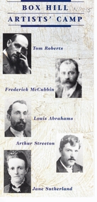
Pamphlet, Box Hill Artists Camp, 1987
Pamphlet written by Box Hill Historical Society IncPamphlet written by Box Hill Historical Society Inc. 1987Pamphlet written by Box Hill Historical Society Incroberts, tom, mccubbin, frederick, abrahams, louis, streeton, arthur, sutherland, jane, box hill historical society, box hill artists camp -
Whitehorse Historical Society Inc.
Article, Saint Marks at Forest Hill, 1988
A History of the Anglican church of St Mark the Evangelist at Forest Hill.A History of the Anglican church of St Mark the Evangelist at Forest Hill.A History of the Anglican church of St Mark the Evangelist at Forest Hill.st marks anglican church forest hill, evangelist -
Whitehorse Historical Society Inc.
Document - Ephemera, Back to Box Hill, 1935
Invitation to the opening of the Box Hill Town hall in 1935 (photo).Invitation to the opening of the Box Hill Town hall in 1935 (photo).Invitation to the opening of the Box Hill Town hall in 1935 (photo).box hill town hall, opening -
Whitehorse Historical Society Inc.
Article, Rating on unimproved land values, 1911
A letter from 'Ratepayer' in the Open Column of the Reporter (Box Hill).A letter from 'Ratepayer' in the Open Column of the Reporter (Box Hill) .A letter from 'Ratepayer' in the Open Column of the Reporter (Box Hill). shire of nunawading, mitcham road mitcham, whitehorse road mitcham, station street mitcham -
Whitehorse Historical Society Inc.
Document, Box Hill Gardens Master Plan, 2011
City of Whitehorse plans for Box Hill Gardens, Feb 2011.City of Whitehorse plans for Box Hill Gardens, Feb 2011.City of Whitehorse plans for Box Hill Gardens, Feb 2011.box hill gardens, plans -
Whitehorse Historical Society Inc.
Pamphlet, Know your city, 1970-1980
Series of pamphlets showing the history of Box Hill. Nos. 1,2,3,5.Series of pamphlets showing the history of Box Hill. Nos. 1,2,3,5.Series of pamphlets showing the history of Box Hill. Nos. 1,2,3,5.white horse hotel, woodhouse grove methodist church, box hill and doncaster electric tramway co., city of box hill -
Whitehorse Historical Society Inc.
Map, Surrey Hills to Croydon map, c1980
Surrey Hills to Croydon map, Drake & Co Pty Ltd.Surrey Hills to Croydon map, Drake & Co Pty Ltd.Surrey Hills to Croydon map, Drake & Co Pty Ltd.surrey hills, box hill, blackburn, forest hill, vermont, ringwood, mitcham, nunawading, maps -
Whitehorse Historical Society Inc.
Newspaper - Article, Graveyard stories, 17/11/1993
Graveyard stories, article by Heather Thomas on Box Hill cemetery.box hill cemetery -
 Whitehorse Historical Society Inc.
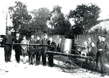
Photograph, Daniel Harvey Staff
Daniel Harvey Staff at Box Hill Premises Water Pump.daniel harvey -
 Whitehorse Historical Society Inc.
Photograph, Daniel Harvey Staff
Black and white photo of Daniel Harvey Box Hill Staff.daniel harvey -
 Whitehorse Historical Society Inc.
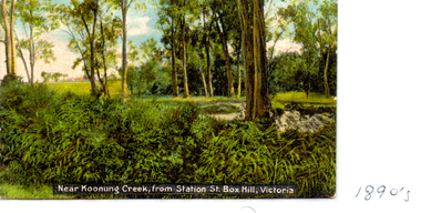
Photograph, Koonung Creek, C.1890's
Near Koonung Creek from Station Street, Box Hill.koonung creek -
 Whitehorse Historical Society Inc.
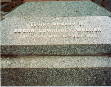
Photograph, E.E. Walker Tombstone
Coloured photo of E.E. Walker Tombstone in Box Hill Cemetery.walker, edgar edwardes, box hill cemetery -
 Whitehorse Historical Society Inc.
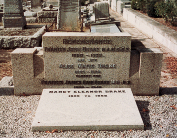
Photograph, Drake Family Tombstone
Coloured photo of Drake Family Tombstone at Box Hill Cemetery.drake, francis john, dr., alice, francis james, nancy, box hill cemetery -
 Whitehorse Historical Society Inc.
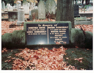
Photograph, Schwerkolt Family Tombstone
Coloured photo of Schwerkolt Family Tombstone in Box Hill Cemetery.schwerkolt, louis, paulina, kruse, dorothea, bertha, johann august, violet -
 Whitehorse Historical Society Inc.
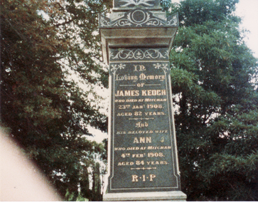
Photograph, Keogh Family Tombstone
Coloured photo of Keogh Family Tombstone in Box Hill Cemetery.keogh, james, ann, box hill cemetery -
 Whitehorse Historical Society Inc.
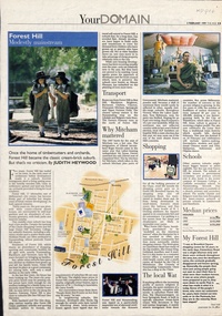
Newspaper - Article, Forest Hill: Modestly mainstream, 3/02/1999
Brief history of the development of Forest Hill and facilities available to residents.residential development, hall, noel, canterbury road, forest hill, burwood highway, vermont south, forest hill -
 Whitehorse Historical Society Inc.
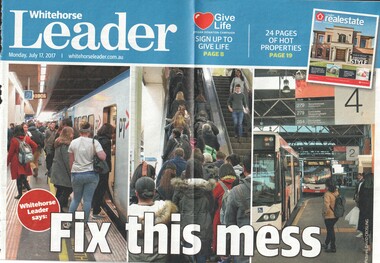
Article, Fix This Mess, 2017
The Whitehorse Leader is demanding that a report on the Box Hill interchange be released.The Whitehorse Leader is demanding that a report on the Box Hill interchange be released.The Whitehorse Leader is demanding that a report on the Box Hill interchange be released.box hill railway station, box hill grand central shopping centre, public transport, city of whitehorse, victoria police force -
 Whitehorse Historical Society Inc.
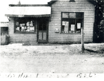
Photograph, Forest Hill Post Office, 1926
Black and white photo of Forest Hill Post Office.(Copy)forest hill post office -
 Ballarat Heritage Services
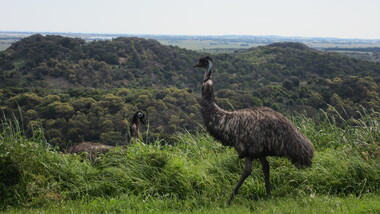
Photograph - Digital photographs, L.J. Gervasoni, Emus at Tower Hill Koroit, 2015
Digital images of emus on Tower Hill near Koroit, Victoriakoroit, moyne shire, volcano, maar, game reserve, tower hill, tower hill, emu, wildlife, native, bird, flightless -
 Ballarat Heritage Services
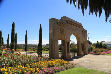
Photograph - Digital photographs, L.J. Gervasoni, White Hills Botanic Gardens, c2015
Colour photograph of an entrance arch at the White Hills Botanical Gardens.botanic garden, white hills, white hills botanic gardens, war memorial, arch, commemoration, bendigo -
 Ballarat Heritage Services
Photograph - Colour, Slab Building with Canvas Roof at Sovereign Hill, 2015, 03/03/2015
Colour photograph of a slab building at Sovereign Hill, Ballarat East.sovereign hill, architecture, slab building, canvas roof