Showing 2558 items
matching aerial
-
 Glenelg Shire Council Cultural Collection
Photograph - Photograph - aerial view of Portland, c. 1954
Black and white aerial photograph of coastline around Portland. Black border, scale all sides, 5 rows of 3 't' at regular intervals. Both sides of headland can be seen. 60/40 ocean to landFront: '784 - 150 - handwritten, white, border 'RUN 7 A PORTLAND', printed, white, borderaerial photography, central portland, portland harbour, south west coastline -
Glenelg Shire Council Cultural Collection
Photograph - Photograph - Main Breakwater construction, Portland, n.d
Port of Portland Authority ArchivesFront: Purplestamp- '14 Feb 1958" Back: Purple stamp- '14 Feb 1958'port of portland archives, harbour construction, main breakwater -
Glenelg Shire Council Cultural Collection
Photograph - Photograph - Main Breakwater construction, Portland, n.d
Port of Portland Authority ArchivesFront: 'c'- Pink texta Back: 'c' - Pink textaport of portland archives, harbour construction, main breakwater, fishermans breakwater, ocean pier -
Glenelg Shire Council Cultural Collection
Photograph - Photograph - Main Breakwater construction, Portland, n.d
Port of Portland Authority ArchivesFront: Purple stamp- '14 Jan 1958' Back: Purplestamp- '14 Jan 1958'port of portland archives, aerial photography, portland harbour -
 Bendigo Historical Society Inc.
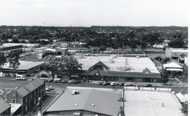
Photograph - AERIAL VIEW BENDIGO, 1995
Black and white photo: aerial view Mollison St., Jewel Shopping complex ( Noelene Wild 7/2000 ) from St. Paul's tower ? Mollison St. left to right foreground. 'B22A' black lead on rear.Peter Hyettplace, aerial view of bendigo -
Port Melbourne Historical & Preservation Society
Photograph - Aerial view of Yarra River and surrounds, 1990s
COPYRIGHT THE AGE Aerial photograph showing the Yarra River, Webb Dock, Port Melbourne beach, Princes pier, West Gate Bridge, Maribyrnong River, Swanston Dock and Melbourne City skyline. Taken mid 1990sStamped "Copyright. This photograph may not be reproduced without permission in writing from the Photo sales department of "the Age"'built environment - commercial, engineering - bridges, fishermans bend, natural environment - beaches and foreshore, piers and wharves - princes pier, piers and wharves - webb dock, transport - shipping, yarra river, west gate bridge, sandridge beach, maribyrnong river, swanston dock -
 Bendigo Historical Society Inc.
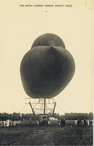
Postcard - BASIL WATSON COLLECTION: POSTCARD: AIRSHIP (ASTRA TORRES), ca. 1914
Black and white postcard - Airship (Astra Torres) titled 'The Astra Torres Airship (Front View)' showing tethered airship on field with personnel, mainly in white uniform, possibly navy personnel. 'Our Aerial Defence Series'John Drew, Aldershot and Farnboroughmilitary, aviation, airship 'astra torres' -
Canterbury History Group
Ephemera - Very rare development site, 87-101 Maling Road Canterbury, 28/10/2010 12:00:00 AM
A 4 size coloured card advertising the auction on 28 October 2010, by Castran, John of the D.H. Bradshaw Garage site. Includes four coloured photographs, one an aerial photograph of the site and its surrounds, and the site plan.canterbury, maling road, d.h. bradshaw auto service, aerial photographs, maling road shops, shops, advertisements, castran> john, petrol stations -
 Lakes Entrance Historical Society
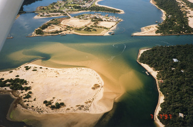
Photograph - Lakes Entrance, 1997
Date made 7 July 1997Colour photograph being an aerial view of the western end of Cunninghame Arm, showing the entrance between the hummocks, Bullock Island, entrance to North Arm, Snake Island surrounded by sand build-up. Lakes Entrance Victoriatopography, waterways, aerial photograph, boats and boating, township, islands -
Moorabbin Air Museum
Book - History of Photo Reconnaissance from pre WW1 to 2003, areas of operations and planes used, EYES of the RAF A History of Photo-Reconnaissance, ROY CONYERS NESBIT, EYES of the RAF A History of Photo-Reconnaissance, 2003
History of Photo Reconnaissance from pre WW1 to 2003, areas of operations and planes used, EYES of the RAF A History of Photo-ReconnaissanceGenerally white cover showing upper blue tinged b/w photo of WW1 bi-plane on ground and four smaller photos at bottom of camera, aerial view of sea port, portrait of person, jet in flightnon-fictionHistory of Photo Reconnaissance from pre WW1 to 2003, areas of operations and planes used, EYES of the RAF A History of Photo-Reconnaissance -
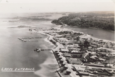
 Lakes Entrance Historical Society
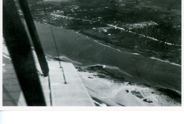
Photograph - Lakes Entrance, Bulmer H D, Whiters Camp Park, 1940c
Black and white copy photograph of aerial view of eastern approach, showing Princes Highway, Whiter's Camp Park, sandy outer barrier beside Cunninghame Arm, distant view of North Arm. Lakes Entrance Victoriawaterways, township -
 Lakes Entrance Historical Society
Photograph - Lakes Entrance, 1940c
Also black and white postcard of same view number 03853.1 size 8.5 x 14 cm . c1940Black and white aerial photograph of town looking west from Mechanics Street to Bullock Island with Kalimna escarpment and Rigby Fraser and Flanagan Islands in distance, Avenue of Honour Cypress trees on foreshore Lakes Entrance Victoriaaerial photograph, settlement, caravan parks, camping, ocean -
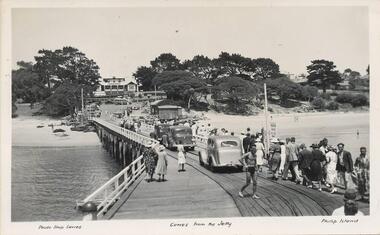 Phillip Island and District Historical Society Inc.
Photograph - Post Cards, A. J. Murray et al, c 1940
A collection of 6 postcards and 1 photograph taken around Phillip Island. Donated by Julie Barnett.Photograph 228-01. Black & White photograph of the Cowes Pier with vehicles and pedestrians. Rail tracks on pier. Isle of Wight Hotel in background. Sheds at end. Photograph 228-02. Black & White aerial photograph of "Broadwater" Guesthouse, Cowes. Photograph 228-03. Black & White photograph of Cowes Pier with Steamer coming in. Shed at end of Jetty and Cenotaph in the foreground. Looking north. Photograph 228-04. Black & White photograph of a Koala and her young. Photograph 228-05. Black & White photograph looking over the Cowes shoreline near Lover's Walk. Photograph 228-06. Black & White photograph of a group of penguins coming home at dusk at the "Penguin Parade". Photograph 228-07. Black & White photograph of Bert West holding a Shearwater (Mutton Bird) with it's wings outstretched.Photo 01. "Photo Shop Series". "Cowes from the Jetty". Photo 02. Aerial view of "Broadwater" Cowes, Phillip Island. No. 146 Photo 03. "Photo Shop Series". The Jetty. Cowes. Photo 04. "Photo Shop Series". "Koala Bear". Phillip Island Photo 05. "The Rose Series P3416". "Near the Lovers' Walk, Cowes, Phillip Is., Vic. Photo 06. "Penguins, Phillip Island." No. 82. Valentines Series. Photo 07. On Back: Mr West with Mutton bird at Phillip Island.wildlife - koalas, wildlife - penguins, penguin parade, bert west, wildlife - mutton birds, mutton birds, shearwaters, cowes pier phillip island, cowes jetty, lover's walk cowes, broadwater guesthouse cowes phillip island, guesthouses cowes phillip island, julie barnett -
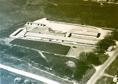 City of Ballarat Libraries
Photograph - Card Box Photographs, Ballarat East High School circa 1965
Aerial view of the Ballarat East High School on the corner of Melbourne Road (now Ballarat - Burrumbeet Rd) and Fussell Street. The campus is now the Woodman's Hill Secondary College.ballarat east high school, woodman's hill secondary college, education, building, public -
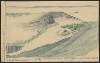 Robin Boyd Foundation
Drawing - Aerial perspective, Tower Hill Lake Reserve Museum, Jun-61
Project: Tower Hill Lake Reserve Museum drawn by Robin Boyd of Grounds, Romberg & Boyd. Drawing no 1. Aerial perspective (same as item PL136 but watercolour and pastel)Sketch, Watercolour on dyeline -
Bialik College
Mixed media (Item) - Shakespeare Grove building 2005
Shakespeare Grove was the former site of Bialik College These images are an aerial shot, photo, and two sketches, created in 2005. Please contact [email protected] to request access to this record. Shakespeare Grove buildingbialik, 2000, 2005, buildings, heritage -
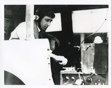 Victoria Police Museum
Photograph (police car), Kodak
Possibly Rupert Bastin 6866, operating a wireless transmitter on the rear floor of a Wireless Patrol Daimler. The transmitter sits on top of the receiver. The wire leading up and to the right connects with the aerial. A wireless operator, possibly Rupert Bastin, and equipment. Circa 1926-1936motor police branch; wireless patrol; wireless operator -
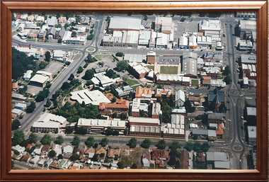 Federation University Historical Collection
Photograph - Framed Colour Photograph, Ballarat School of Mines Campus
The Ballarat School of Mines was the first school of mines in Ausralasia, and was established in 1870.Framed, large format, aerial phototgraph of the Ballarat School of Mines campus. Includes the Brewery complex, E.J. Tippett Library, Administration Building, Brew Tower, Brewery chimney, Former Courthouse, former gaol and Hillman recreation hall.ballarat school of mines, ballarat gaol, e.j. tippett library, administration building, former ballarat gaol, hillman recreation hall -
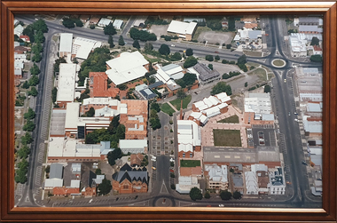 Federation University Historical Collection
Photograph - Framed Colour Photograph, Ballarat School of Mines Campus
The Ballarat School of Mines was the first school of mines in Ausralasia, and was established in 1870.Framed, large format, aerial phototgraph of the Ballarat School of Mines campus. Includes the Brewery complex, E.J. Tippett Library, Administration Building, Brew Tower, Brewery chimney, Former Courthouse, former gaol and Hillman recreation hall.ballarat school of mines, ballarat gaol, e.j. tippett library, administration building, former ballarat gaol, hillman recreation hall, corbould hall, m.b. john building -
Glenelg Shire Council Cultural Collection
Photograph - Photograph - aerial view of Portland coastline, c. 1954
Black and white aerial photograph of coastline around Portland. Black border, scale all sides, 5 rows of 3 't' at regular intervals. Mostly ocean, small area of land top left. See Other Information.Front: '820 - 47' - handwritten, white, border 'RUN 6' 'PORTLAND', printed, white, borderport of portland archives, aerial photography, portland harbour, south west coastline -
Glenelg Shire Council Cultural Collection
Photograph - Photograph - aerial view of Portland, c. 1954
Black and white aerial photograph of coastline around Portland. Black border, scale all sides, 5 rows of 3 't' at regular intervals. Half ocean, half land, separated by beach, further left than 8472Front: '607 - 91 ' - handwritten, white, border 'RUN - 6 PORTLAND', printed, white, borderaerial photography, central portland, portland harbour, south west coastline -
Glenelg Shire Council Cultural Collection
Photograph - Photograph - aerial view of Portland, c. 1954
Black and white aerial photograph of coastline around Portland. Black border, scale all sides, 5 rows of 3 't' at regular intervals. 75/25 land to ocean. Further left than 8475, ?end of beach.Front: '607 - 94 ' - handwritten, white, border 'RUN - 6 PORTLAND', printed, white, borderaerial photography, central portland, portland harbour, south west coastline -
Glenelg Shire Council Cultural Collection
Photograph - Photograph - aerial view of Portland, c. 1954
Black and white aerial photograph of coastline around Portland. Black border, scale all sides, 5 rows of 3 't' at regular intervals. Curved section of coastline top right corner. 90/10 ocean to landFront: '784 - 154'- handwritten, white, border 'RUN 7 A PORTLAND', printed, white, borderport of portland archives, aerial photography, portland harbour, south west coastline -
Glenelg Shire Council Cultural Collection
Photograph - Photograph - aerial view of Portland, c. 1954
Black and white aerial photograph of coastline around Portland. Black border, scale all sides, 5 rows of 3 't' at regular intervals. Right hand end of headland no longer visible. 50/50 ocean to land.Front: '784 - 151'- handwritten, white, border 'RUN A PORTLAND', printed, white, borderaerial photography, central portland, portland harbour, south west coastline -
Glenelg Shire Council Cultural Collection
Photograph - Photograph - aerial view of Portland, c. 1954
Black and white aerial photograph of coastline around Portland. Black border, scale all sides, 5 rows of 3 't' at regular intervals. Another curve in land, away from ocean. 70/30 ocean to landFront: '784 - 153' - handwritten, white, border 'RUN 7 A PORTLAND', printed, white, borderaerial photography, central portland, portland harbour, south west coastline -
 Kiewa Valley Historical Society
Maps 3D - National Parks
Used by the employees of National Parks. The maps show the topography and contours in 3D when used with the stereoscope KVHS 0743. This enables the photographed area to be compared to previous photos and enables the planning of construction of eg. new roads etc. Digital information is now available.These photographs give the topography and contours of vast local areas eg. Mt Feathertop and Tawonga township.when used with a stereoscope. Black and white large aerial photos of the Bogong High Plains area. 14 to 20 of them all on thick paper and the same size as the brown wooden box which holds them. The box hasn't got a lid at the top.Identified and catalogued by National Parksmaps showing topography, national parks, stereoscope -
 Ringwood and District Historical Society
Photograph, Photos of last houses to face demolition at Camberwell. c1970s, c1983
One of the last houses to face demolition.Single fronted weatherboard with striped veranda blind, brick chimney over front rooms with TV aerial. Green painted walls. Red painted iron roof over veranda and under veranda rail. Adjacent to Target entrance.The 'Miss Stayput' house in the car park out the front of Target in Camberwell. You can even see the Target logo on the building. The house was owned by Mary Campigli, who defied the council order to move, and won her case in court. She stayed in the house, surrounded by a car park until she died in 1983 at the age of 94. The house was finally demolished soon after. -
Glenelg Shire Council Cultural Collection
Photograph - Photograph - View of Portland and foreshore, 21/03/1972
Port of Portland Authority archives.Front: (no inscriptions) Back: (no inscriptions)port of portland archives, portland harbour, henty park, industrial estate, canal court -
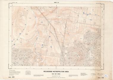 Ringwood and District Historical Society
Map - Melbourne Metropolitan Area Base Map Series, Sheet 215 - Ringwood area, 1967
Map prepared by Dept of Lands and Survey and MMBW from State Aerial Survey June 1957 and Cadastral Survey information July 1967. This sheet comprises parts of Municipalities of Doncaster & Templestowe, Nunawading and Ringwood, and Parishes of Nunawading and Warrandyte.Scale: 400 feet to 1 inch. Contours at 5 feet vertical interval. By Authority: A.C. Brooks, Commonwealth Printer, Melbourne. -
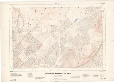 Ringwood and District Historical Society
Map - Melbourne Metropolitan Area Base Map Series, Sheet 216 - Ringwood area, 1967
Map prepared by Dept of Lands and Survey and MMBW from State Aerial Survey June 1957 and Cadastral Survey information July 1967. This sheet comprises parts of Municipalities of Croydon, Doncaster & Templestowe, and Ringwood, and Parishes of Ringwood and Warrandyte.Scale: 400 feet to 1 inch. Contours at 5 feet vertical interval. By Authority: A.C. Brooks, Commonwealth Printer, Melbourne.