Showing 1526 items
matching aerial photograph
-
 Ballarat Heritage Services
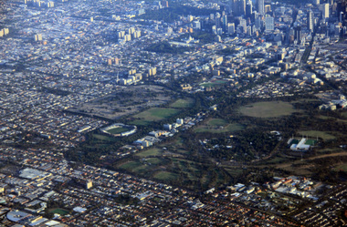
Digital Photograph, L.J. Gervasoni, Royal Park CBD and zoo from the air, 2016
Digital Image showing an aerial view of the Melbourne Central Business District and Royal Park.aerial, melbourne, yarra river, cbd, royal park, zoo -
 Ballarat Heritage Services
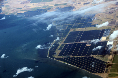
Digital Photograph, L.J. Gervasoni, werribee farm from the air, 2016
Digital Image showing an aerial view of the Melbourne Central Business District and Royal Park.aerial, melbourne, werribee farm, sewerage -
 Ballarat Heritage Services
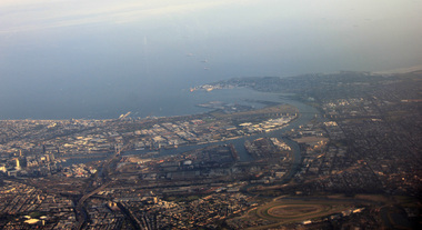
Photograph, L.J. Gervasoni, Mouth of the Yarra River from the air, 2016
Digital Image showing an aerial view of the mouth of the Yarra River from the airaerial, melbourne, mouth, yarra, river, port phillip bay, flemington, docklands, bolte bridge, west gate bridge -
 Ballarat Heritage Services
Photograph, Townscape
... Office goldfields townscape aerial Photograph of a town Townscape ...Photograph of a towntownscape, aerial -
 Ballarat Heritage Services
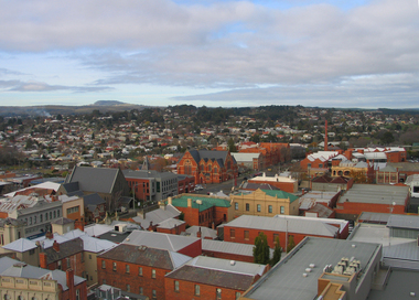
Photograph, L.J. Gervasoni, Ballarat from the Town Hall Tower, 2006, 14/06/2006
Ballarat looking toward Mount Buninyong, from the Ballarat Town Hall tower. ballarat, aerial, ballarat town hall tower -
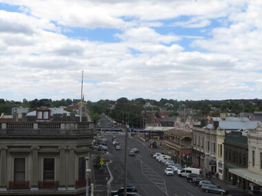
 Ballarat Heritage Services
Photograph, L.J. Gervasoni, Ballarat from the Town Hall Tower, 2006, 14/06/2006
Ballarat looking toward Mount Buninyong, from the Ballarat Town Hall tower. ballarat, aerial, ballarat town hall tower -
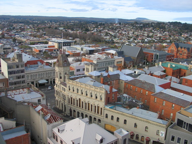
 Ballarat Heritage Services
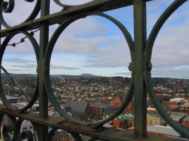
Photograph, L.J. Gervasoni, Ballarat from the Town Hall Tower, 2006, 14/06/2006
Ballarat looking toward St Patrick's Cathedral, from the Ballarat Town Hall tower. ballarat, aerial, ballarat town hall tower, st patrick's cathedral, sturt street -
 Ballarat Heritage Services
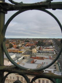
Photograph, L.J. Gervasoni, Ballarat from the Town Hall Tower, 2006, 14/06/2006
Ballarat looking toward the former Ballarat Post Office, from the Ballarat Town Hall tower. ballarat, aerial, ballarat town hall tower, sturt street, ballarat post office -
 Ballarat Heritage Services
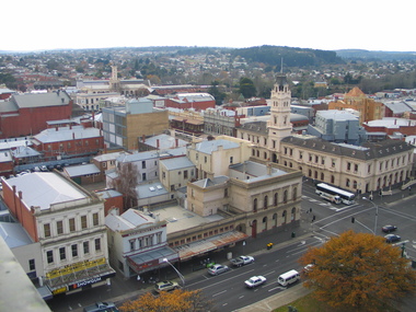
Photograph, L.J. Gervasoni, Ballarat from the Town Hall Tower, 2006, 14/06/2006
Ballarat looking toward Craig's Royal Hotel, from the Ballarat Town Hall tower. ballarat, aerial, ballarat town hall tower, craig's hotel -
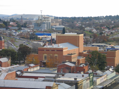 Ballarat Heritage Services
Photograph, L.J. Gervasoni, Ballarat from the Town Hall Tower, 2006, 14/06/2006
Ballarat looking toward Civic Hall, from the Ballarat Town Hall tower. ballarat, aerial, ballarat town hall, civic hall -
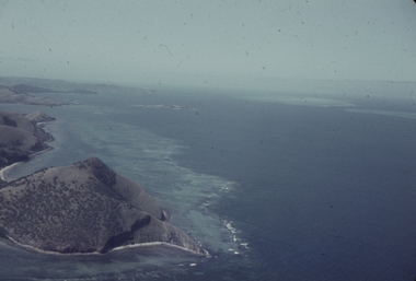 Ballarat Heritage Services
Slide, Dorothy Wickham, Port Moresby, Papua New Guinea, 1958
This photograph was taken around 1958.Scanned from a coloured slideView from this sidepapua new guinea, papuans, port moresby, aerial -
 Whitehorse Historical Society Inc.
Photograph, Burwood Technical School
Burwood Technical School was located on the south west corner of Middleborough and Elgar RoadsStrip of four coloured aerial photo of the Burwood Technical School Buildings taken sometime between 1986 and 1992.schools, burwood technical school -
 Ballarat Heritage Services
Photograph - Photograph - Colour, Ballarat From the Regent Cinema, Lydiard Street North, Ballarat, 2015, 27/12/2016
Lydiard Street is known as an axcellent example of Victorian architecture.Various views of Ballarat's Lydiard Street Northballarat, lydiard street north, buildings, aerial, birds eye, sebastions, regent cinema -
 City of Ballarat Libraries
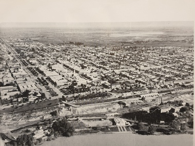
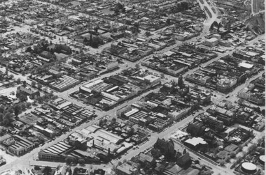
Photograph, Aerial View of the Ballarat CBD in 1957 / 1958
This aerial view of the Ballarat CBC was taken sometime in 1957 or 1958. Sturt Street can be seen running from the right centre to top left.aerial view, sturt street, ballarat, central business district, cbd -
 City of Ballarat Libraries
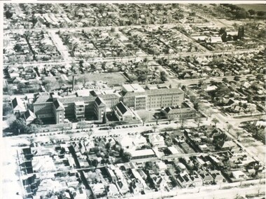
Photograph - Card Box Photographs, Queen Elizabeth Geriatric Centre, Ballarat circa 1945
Aerial view of the QEGC on Ascot Street.queen elizabeth geriatric centre, qegc, ballarat, ascot street, building, public building, medical -
 City of Ballarat Libraries
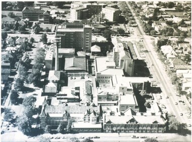
Photograph - Card Box Photographs, Ballarat Base & St John of God Hospitals, Ballarat circa 1960
Aerial views of the Ballarat Base and St John of God Hospitals.ballarat base hospital, st john of god hospital, ballarat, drummond street noth, building, aerial view -
 City of Ballarat Libraries
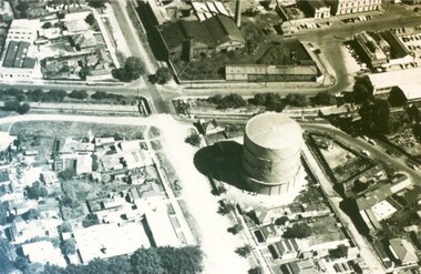
Photograph - Card Box Photographs, Gas Works, Ballarat circa 1968
These gas works were located on the corner of Albert and Dana Streets.gas works, aerial view, manufacturing, albert street, dana street -
 City of Ballarat Libraries
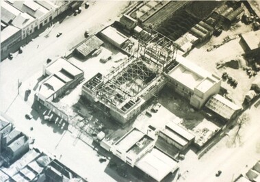
Photograph - Card Box Photographs, Aerial view of the Civic Hall under construction, Ballarat circa 1951
This photo shows the buildings still standing around the Civic Hall as it was being constructed.civic hall, ballarat, mair street, aerial view, armstrong street north, building, construction, public building -
 City of Ballarat Libraries
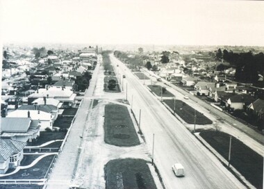
Photograph - Card Box Photographs, Victoria Street, Ballarat circa 1940
Aerial view looking west from Stawell Street.victoria street, ballarat, ballarat east, streetscape, bulding, garden, houses, private dwelling, vehicle, aerial view -
 City of Ballarat Libraries
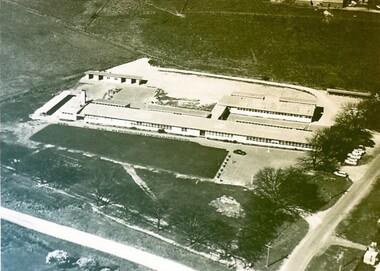
Photograph - Card Box Photographs, Ballarat East High School circa 1965
Aerial view of the Ballarat East High School on the corner of Melbourne Road (now Ballarat - Burrumbeet Rd) and Fussell Street. The campus is now the Woodman's Hill Secondary College.ballarat east high school, woodman's hill secondary college, education, building, public -
 City of Ballarat Libraries
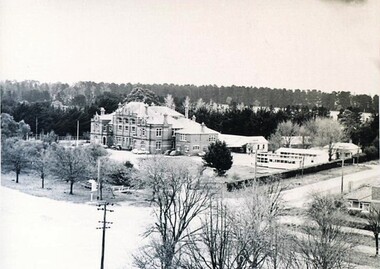
Photograph - Card Box Photographs, Ballarat High School circa 1960
Aerial view of the Ballarat High School site Gilles Street. Notice the re-locatable classrooms.ballarat high school, gillies street, education, building, streetscape, public -
 Whitehorse Historical Society Inc.
Book - History, Wandinong Sanctuary Advisory Committee, The Wandinong Story (2023), October 2023
... of Ronley street and the family plantation as well as aerial ...The book describes the origins of Wandinong Sanctuary, Blackburn as a home for the Hookes family from 1913 and its transformation into a public park in 1973.Color Reprint of 110 pp, with a new front page and new color photographs of the vegetation. non-fictionThe book describes the origins of Wandinong Sanctuary, Blackburn as a home for the Hookes family from 1913 and its transformation into a public park in 1973.wandinong sanctuary, hooke janet, hooke arthur -
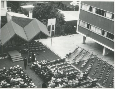 International House, The University of Melbourne
Photograph (Item), Aerial view of the official opening of the Samuel Wadham Wing at International House, 1963
The Samuel Wadham Wing was the second purpose-built accommodation building at International House at the University of Melbourne. The building was officially opened by Lord Richard Casey (1890–1976) on 23 March 1963. -
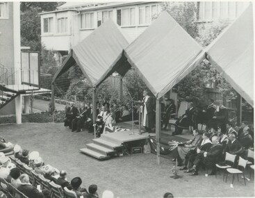 International House, The University of Melbourne
Photograph (Item), Aerial view of speakers and some audience members at the opening of the Samuel Wadham Wing at International House
ceremony -
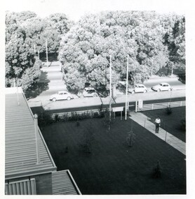 International House, The University of Melbourne
Photograph (Item), Aerial view of a young man standing on the front pathway at the main entry to International House
-
 Inverloch Historical Society
001024 - Photograph - Inverloch - c1982 - Pine Lodge aerial view - from James Wyeth
-
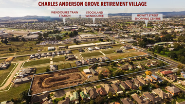 Old Colonists' Association of Ballarat Inc.
Photograph - Photograph - Colour, Aerial View of Charles Anderson Grove, Ballarat, 2017, 05/2017
Drone footoge featuring the Old Colonists' Association of Ballarat Inc., retirement village at Charles Anderson Grove. The area to the left is being prepared for 18 additional cottages to be built. old colonists' association of ballarat, drone footage, ballarat, aerial, charles anderson grove, retirement village -
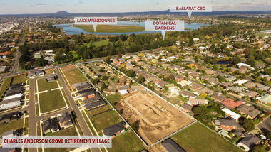 Old Colonists' Association of Ballarat Inc.
Photograph - Photograph - Colour, Aerial View of Charles Anderson Grove Retirement Village, Ballarat, 2017, 05/2017
Drone footage of Charles Anderson Grove Retirement Village off Gillies Street, Ballarat.charles anderson grove, old colonists' association, ballarat, drone footage, aerial, ballarat, retirement village -
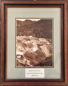 Tramways/East Melbourne RSL Sub Branch - RSL Victoria Listing id: 27511
Picture, Bukit Knuckle
Framed print of a sepia photograph showing the camp at 'Bukit Knuckle', an operational base of the 3RAR in Borneo. Images shows an aerial view of the camp and surrounding landscape. Underneath the print is added 'BUKIT KNUCKLE' B COV 3RAR OPERATIONAL BASE, BORNEO 1965 On reverse is marked 'Donated by Keith Matthews 1995'bukit knuckle, sungei koemba, 3 rar, indonesia malaysia confrontation -
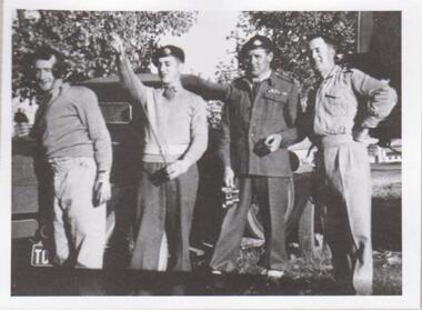 8th/13th Victorian Mounted Rifles Regimental Collection
Photograph
The 8th/13th Victorian Mounted Rifles was raised as a regiment of the Royal Australian Armoured Corps on 1 May 1948 with Headquarters in Melbourne and squadrons in Sale, Benalla/Wangaratta and Albury. In 1955 Regimental Headquarters moved to Wangaratta and a second squadron was located at Albury. The Sale squadron transferred to 4th/19th Prince of Wales’s Light Horse. In 1977 8/13 VMR Regiment was reduced to an independent squadron A Squadron 8th/13th Victorian Mounted Rifles and in 1991 was linked with 4th/19th Prince of Wales’s Light Horse forming the VMR Squadron of that regiment.Unique collection of photographs showing the first years of an armoured regiment of the post-Second World War era Citizen Military Forces showing equipment, uniforms, training and social activity and some personalities.Black and white photograph of four soldiers in variety of uniforms standing beside civilian utility vehicle. One is wearing winter service dress, one in khaki drill uniform, two are wearing V neck Army jumpers. One is wearing headphones, one haslength of radio aerial. One of a collection of photographs of 8th/13th Victorian Mounted Rifles Regiment between 1948 and 1951." Cunningham Alternative Command Vehicle. No. 1 Set Training. John Neale, George Atkinson, Bill Purcell, Ron Braddy. "