Showing 17152 items
matching bay-bridge
-
 Eltham District Historical Society Inc
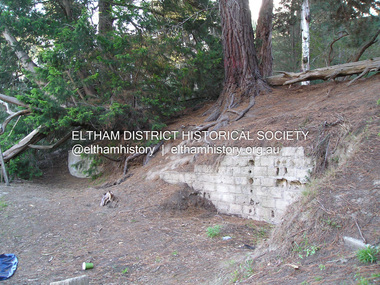
Photograph, Fay Bridge, Ruins at Griffith Park, Eltham near the Yarra River, June 2016
Griffith Park is the former property and home of Cr Fred Griffith in the 1950sfay bridge collection, 2016-06, griffith park, ruins -
 Eltham District Historical Society Inc
Photograph, Fay Bridge, The Love Shack, 195 Laughing Waters Road, Eltham, 22 July 2016
Gordon Ford built this shack on the Yarra at Laughing Waters Road. Bernie Bragg used to live there for a period of time. Gordon Ford and photographer Sue Winslow were married in 1965. They set up home in an old log cabin on the property Gordon had purchased in 1954 on Laughing Waters Road. Situated between the Yarra River and Overbank Road, Gordon had built a small mud-brick shack on the river and a pontoon. Over the decades the shack has been locally referred to as “the love shack”, the “rooting shack” or simply “Gordon’s shack”. Gordon and Sue commissioned local builder Graeme Rose to do a wattle and daub renovation and extension to the old log cabin on the north side of Laughing Waters Road. The work had only just been completed in 1965 when a bushfire swept through the area and destroyed the cabin. Gordon and Sue relocated to his property, Fulling, in Pitt Street, Eltham. In 1970 work started on a new house at the Laughing Waters property. Originally known as the Banana House, it is now known as Boomerang. Designed by Alistair Knox, the mud-brick house includes iron window grilles made by Matcham Skipper that puncture the curved mud walls. The grilles were made from ‘off-pressings’ from the Sidchrome tool works in Heidelberg. Gordon, Sue and family moved into the house in 1972. Their marriage fell apart and Sue moved to Sydney with the children around the same time Gordon commenced building Birrarung just below Boomerang on the Laughing Waters Road block. After the Fords moved out, Boomerang it was rented out to various share households of students, musicians, artists and environmentalists for twenty-four years. Gordon Ford sold Birrarung and Boomerang to Melbourne Water in 1999. The Laughing Waters Artist in Residence Program was developed as a partnership between Parks Victoria and Nillumbik Shire Council. Boomerang was deemed unfit for habitation so was used as a day studio only. By 2001 Boomerang was in a poor state of repair and by 2002 the last artist in residence was to use the house as a studio. Nillumbik Shire Council had been granted funds from the Melbourne Community Fund to restore both Boomerang and Birrarung but it was apparent in early 2003 that the funds would be insufficient to restore both houses. Boomerang was infested with termites which presented a risk to any occupants and so the decision was made to close Boomerang and concentrate funding on Birrarung. Boomerang was fenced off for safety and to prevent intrusion and remains ‘caged’ today (2023). However, it is readily apparent the property has been occupied by squatters over the years. By 2023 it was clear that the squatters had abandoned the property and sections of the roof structure have given away in some areas and collapsed internally. For a more in-depth description and history of the property and that of Gordon and Sue Ford, see Jane Woollard's book, "Laughing Waters Road; Art, Landscape & Memory in Eltham" published 2016.fay bridge collection, 2016-07-22, bernie's hut, birrarung, gordon ford, gordon's shack, laughing waters, laughing waters road, love shack, yarra river -
 Eltham District Historical Society Inc
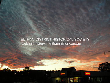
Photograph, Fay Bridge, Sunset, Main Road, Eltham, 22 July 2016
Viewed from intersection of Main Road and Luck Street overlooking Liquorland (previously Blockbuster Video and now Grill'd Eltham)fay bridge collection, 2016-07-22, blockbuster, eltham, grill'd, liquorland, luck street, main road, sunset -
 Eltham District Historical Society Inc
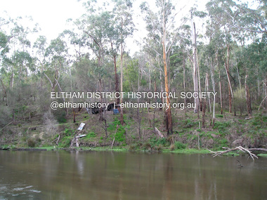
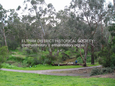
Photograph, Fay Bridge, Alistair Knox Park, Eltham, 13 October 2016
fay bridge collection, 2016-10-13, alistair knox park, diamond creek (creek), eltham -
 Eltham District Historical Society Inc
Photograph, Fay Bridge, Ruins beside the Diamond Creek at Wattle Glen, 13 October 2016
The newly constructed Diamond Creek Trail from Diamond Creek to Wattle Glen completed in February 2021 winds around these ruins just pass the high transmission power lines near Herberts Lane and Collard Drive From Jean Verso, Nillumbik Historical Society, 15 April 2021 William Wandless Herbert bought the surrounding 100 acres in 1852. He was a native of Northumberland and the Scottish Borders who arrived in Melbourne in 1847. The house on the top of the mound would have been built not long after he bought the land; the farm was named "Greenhills". He married Elizabeth Wilson, daughter of John Wilson who had been in Diamond Creek since about 1846. Their first child was born in 1854 so there would be some form of dwelling from about that time. They had eight children who all survived to a good age. His will describes the house as part stone and part wood and of four rooms. Nillumbik Historical Society (NHS) believe it was one of the earliest if not the earliest house, in this part of the district. The remains of the stone house foundations are on top of the mound (photos on the VHD page) and the barn walls are on the north and to the east side of the mound. NHS is not sure how much or which part of the surrounding area was covered by the barns but they were large enough to hold dances after the race meetings that were held in the late 1880's on the adjacent creek flats. It would make sense with the lay of the land that they covered some of the ground to the north and east and used for farm storage, packing sheds for their apple and pear orchards and also for supporting the Nillumbik Gold Mine the family worked to the north up the gully. The path that comes down the gully and runs into the trail goes past the mine site which was on the west side of the gully a couple of hundred metres up from the flats. Heritage Victoria link for the site - https://vhd.heritagecouncil.vic.gov.au/places/12203fay bridge collection, 2016-10-13, diamond creek, diamond creek trail, ruins, wattle glen, william wandless herbert, greenhills, elizabeth wilson -
 Eltham District Historical Society Inc
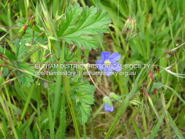
Photograph, Fay Bridge, Blue Cranespill, 895 Main Road, Eltham, 15 October 2016
A blue Cranespill Geranium growing on the verge of the carpark of the former Eltham Council offices at 895 Main Road. In the Advisory list of environmental weeds in Victoria (White, Cheal, Carr et al April 2018), this plant is a declared environmental weed in Victoria with a medium risk. At a Society Heritage Excusrion conducted Saturday, September 2, 2023 it was noted that the banks of the carpark where this photo was taken had recently been sprayed and weed growth was dying.fay bridge collection, 895 main road, 2016-10-15, blue cranesbill, environmental weed -
 Eltham District Historical Society Inc
Photograph, Fay Bridge, Former office of Ace Contractors Group Pty. Ltd., 18 Brisbane Street, Eltham, November 2016
Since demolished and replaced with Bunnings Warehouse (Trades) building in 2021fay bridge collection, 18 brisbane street, 2016-11, ace contractors group pty ltd, bunnings warehouse, eltham -
 Eltham District Historical Society Inc
Photograph, Fay Bridge, Toe-hold tree, Heritage Excursion, Killeavey, Laughing Waters Road, Eltham, November 2016
This scar or 'toe hold' tree fell over 50 yrs ago. It had died 50yrs before it fell and is estimated to be around 400 years old. It has a diameter of 1.3 m and is the only 'toe hold' tree in Nillumbik. Heritage Excursion - Killeavey Walk and Talk - Saturday 5th November Jane Woollard’s book Laughing Waters Road Art Landscape and Memory in Eltham devotes several chapters to the property Killeavey situated on the Yarra River at the end of Reynolds Road, Eltham. Jane has written about the natural history and indigenous history of the area and stories of the family who lived at Killeavey for many years. Killeavey was the home of Sir William Irvine, Victorian and Federal Parliamentarian and Supreme Court Judge. Later it was the home of his daughter Beatrice Morrison, a significant figure in the Eltham community. The original house was destroyed by fire and its replacement was demolished by Parks Victoria. Its sits high above the Yarra River and contains significant garden remnants. The surrounding bushland is valued for its significant plant communities. In September 2011 we visited Killeavey but without the benefit of the information more recently available from Jane’s research. We are fortunate that Jane will be joining us on this walk. There will be an extended stop at the house site for a discussion on the environment and history of the area. Inside the cover panels of Jane’s book is a reproduction of the complete artwork from ‘The Symbiogenesis Project: Laughing Waters 2011 by Aviva Reed and Paul Kalemba, as displayed in the Eltham Town Centre. This walk will start at 2 pm on Saturday 5th November at the corner of Laughing Waters and Overbank Roads. - EDHS Newsletter No. 230 October 2016fay bridge collection, 2016-11-05, activities, eltham, eltham district historical society, heritage excursion, kileavey, laughing waters road, parks victoria, cameron beardsall -
 Eltham District Historical Society Inc
Photograph, Fay Bridge, Eastern boundary of former Warrandyte Aboriginal Reserve, North Warrandyte, 7 November 2016
Two bronze commemorative plaques on rocks, unveiled by Wurundjeri Tribe Council Elders, mark two eastern boundaries of the former Warrandyte Aboriginal Reserve on the north and south sides of the Yarra. This project was initiated by Nillumbik Reconciliation Group in close association with Reconciliation Manningham and the Wurundjeri Tribe Council, as a means of commemorating the last great corroboree of the Kulin Nation which was held at Pound Bend in March 1852. This plaque is on the Nillumbuk side of the Yarra, accessed via The Boulevard, North Warrandyte. The plaque is set on a rock approximately 50 metres before the turning circle at the end of The Boulevard. Plaque : Warrandyte Aboriginal Reserve This commemorative rock marks an eastern boundary of the former Warrandyte Aboriginal Reserve established in 1852. Centred on Pound Bend, it covered 1,908 acres on both sides of the Yarra River (Birrarung). That same year saw the last great gathering of the Kulin nation here in Wurundjeri country which was celebrated over two weeks with traditional performance and games. For a few years longer the reserve intermittently served as a ration station.With gold having been discovered at Warrandyte, the Wurundjeri were moved on again but ultimately secured a permanent home at Coranderrk, Healesville. A second commemorative plaque and rock is located on the opposite bank of the Yarra and its confluence with Stony Creek. Melway ref : 23 C 9 Unveiled by Wurundjeri Elder, Uncle Bill Nicholson on 23rd March 2013 Funded by the Robert Bridgford Indigenous Trust (Nillumbik Community Fund) with assistance from Manningham City Council Small Grants Program Ref: Monument Autralia https://monumentaustralia.org.au/themes/culture/indigenous/display/99680-warrandyte-aboriginal-reserve-fay bridge collection, 2016-11-07, aboriginal reserve, north warrandyte, plaques, warrandyte aboriginal reserve -
 Eltham District Historical Society Inc
Photograph, Fay Bridge, Yarra River near the eastern boundary of former Warrandyte Aboriginal Reserve, North Warrandyte, 11 August 2023
Accessed via The Boulevard, North Warrandytefay bridge collection, aboriginal reserve, north warrandyte, warrandyte aboriginal reserve, 2023-08-11 -
 Eltham District Historical Society Inc
Photograph, Fay Bridge, Old Police Lockup, Hurstbridge, 7 November 2017
Site number 19 on the Hurstbridge Heritage Trail, the former Police Lock-up is located at Allwoodfay bridge collection, 2017-11-07, hurstbridge, hurstbridge heritage trail, lockup, allwood -
 Eltham District Historical Society Inc
Photograph, Fay Bridge, Old Police Lockup, Hurstbridge, 20 November 2017
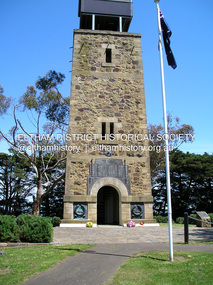
fay bridge collection, 2017-11-20, friends of kangaroo ground war memorial park, memorial park, shire of eltham war memorial, war memorial tower, garden hill, kangaroo ground -
 Eltham District Historical Society Inc
Photograph, Fay Bridge, Old Police Lockup, Hurstbridge, 20 November 2017
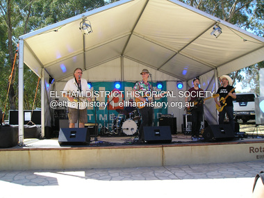
fay bridge collection, 2017-11-20, alistair knox park, eltham festival, wilbur wilde -
 Eltham District Historical Society Inc
Photograph, Fay Bridge, EDHS Heritage Excursion, Eltham Cemetery, 3 March 2018
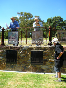
March Excursion - Eltham Cemetery Artworks Newsletter No 236 October 2017 contained a report on the unveiling of a significant new art project at the Eltham Cemetery. Titled “Our Eltham – Artistic Recollections” it features 31 ceramic panels containing artwork with a local history theme. The work is the joint creation of artist Nerina Lascelles and ceramicist Linda Detoma, supported with stonework by Leigh Wykes and steelwork by Neil Carter, all skilled local Nillumbik artisans. The main purpose of our excursion on Saturday 3rd March 2018 at 2.00pm will be to view the panels and will include readings from the interpretive booklet published by the Cemetery Trust. There will also be the opportunity to inspect other artworks within the cemetery. - EDHS Newsletter No. 238 February 2018fay bridge collection, 2018-03-03, eltham cemetery, eltham district historical society, heritage excursion, our eltham artistic recollections, public art -
 Eltham District Historical Society Inc
Photograph, Fay Bridge, Save Community Reserves Rally, 895 Main Road, Eltham, 7 November 2017
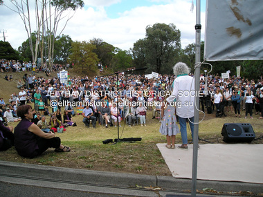
Protest rally against Nillumbik Shire Councillors' proposal to sell off 17 community reserves. Held at the site of the former Shire of Eltham offices, at 895 Main Road, which were demolished in August 1996, followed by a march along Main Road finishing at the Eltham Railway Station car park at Luck Street. Estimated attendance was approximately 3,000.fay bridge collection, 895 main road, 2018-03-04, margaret jennings, nillumbik shire council, parks, save community reserves protest rally, save our reserves -
 Eltham District Historical Society Inc
Photograph, Fay Bridge, EDHS Heritage Excursion, Edendale Farm, 5 May 2018
May Excursion – Edendale Environs Edendale Community Environment Farm in Gastons Road, Eltham now operates as Nillumbik Council’s environmental centre. The historic homestead has undergone a significant restoration and there is on-going development of the site consistent with its community education purpose. The house and the gateway sculpture “The Fences Act” are covered by a Heritage Overlay in the Nillumbik Planning Scheme. Our May excursion will comprise a walk through the farm property and will radiate to other nearby places of historic interest. These will include the site of the Eltham North Adventure Playground to discuss its history and destruction by fire (see page 1 article). Also nearby is Colemans Corner where the early road system has undergone some unusual changes. If time permits we may visit some other nearby places of interest. - EDHS Newsletter No. 239 April 2018fay bridge collection, 2018-05-05, edendale community farm, edendale farm, eltham district historical society, heritage excursion, activities -
 Eltham District Historical Society Inc
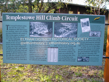
Photograph, Fay Bridge, Templestowe Hill Climb Circuit, 4 July 2018
fay bridge collection, 2018-07-04, templestowe hill climb -
 Eltham District Historical Society Inc
Photograph, Fay Bridge, Longridge, Alexander Road, Warrandyte, 4 May 2019
Situated on the Warrandyte side of the Yarra River opposite Glynn's Dairy Farm, North Warrandyte, the property is in ruins and remains fenced off as of 2023fay bridge collection, glynns, longridge, ruins, warrandyte, 2019-05-04, alexander road -
 Eltham District Historical Society Inc
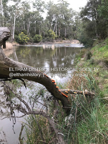
Photograph, Fay Bridge, Remains of apple orchard near the Diamond Creek, Wattle Glen, 11 October 2018
The newly constructed Diamond Creek Trail from Diamond Creek to Wattle Glen completed in February 2021 winds past these apple trees that possibly lined the entrance to the Greenhills property From Jean Verso, Nillumbik Historical Society, 15 April 2021 William Wandless Herbert bought the surrounding 100 acres in 1852. He was a native of Northumberland and the Scottish Borders who arrived in Melbourne in 1847. The house on the top of the mound would have been built not long after he bought the land; the farm was named "Greenhills". He married Elizabeth Wilson, daughter of John Wilson who had been in Diamond Creek since about 1846. Their first child was born in 1854 so there would be some form of dwelling from about that time. They had eight children who all survived to a good age. His will describes the house as part stone and part wood and of four rooms. Nillumbik Historical Society (NHS) believe it was one of the earliest if not the earliest house, in this part of the district. The remains of the stone house foundations are on top of the mound (photos on the VHD page) and the barn walls are on the north and to the east side of the mound. NHS is not sure how much or which part of the surrounding area was covered by the barns but they were large enough to hold dances after the race meetings that were held in the late 1880's on the adjacent creek flats. It would make sense with the lay of the land that they covered some of the ground to the north and east and used for farm storage, packing sheds for their apple and pear orchards and also for supporting the Nillumbik Gold Mine the family worked to the north up the gully. The path that comes down the gully and runs into the trail goes past the mine site which was on the west side of the gully a couple of hundred metres up from the flats. Heritage Victoria link for the site - https://vhd.heritagecouncil.vic.gov.au/places/12203fay bridge collection, 2018-10-11, diamond creek, diamond creek trail, elizabeth wilson, greenhills, wattle glen, william wandless herbert, apple trees -
 Eltham District Historical Society Inc
Photograph, Fay Bridge, Hurstbridge Wattle Festival, 31 August 2018
fay bridge collection, 2018-08-31, hurstbridge wattle festival -
 Eltham District Historical Society Inc
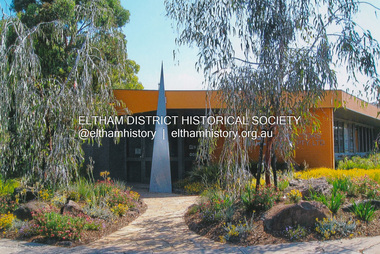
Photograph, Fay Bridge, Eltham Festival; Eltham Woodworkers display at Eltham Community and Reception Centre, 12 November 2018
fay bridge collection, 2018-11-12, eltham community and reception centre, eltham community centre, eltham festival, eltham woodworkers -
 Eltham District Historical Society Inc
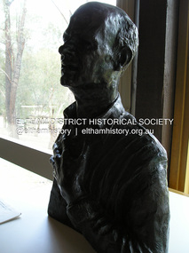
Photograph, Fay Bridge, Bronze bust of George Dreyfus, composer, by Matcham Skipper, Eltham Community and Reception Centre, 12 November 2018
Part of the Nillumbik Art Collectionfay bridge collection, 2018-11-12, eltham community centre, george dreyfus, matcham skipper, nillumbik art collection -
 Eltham District Historical Society Inc
Photograph, Fay Bridge, Le Pine Funeral Home's Packard, 12 November 2018
Part of the Nillumbik Art Collectionfay bridge collection, 2018-11-12, car, eltham festival, le pine funeral home, packard -
 Eltham District Historical Society Inc
Photograph, Fay Bridge, Peck's Dam, Pedersen Way Reserve, Montmorency, 8 February 2019
Part of the Nillumbik Art Collectionfay bridge collection, 2019-02-08, montmorency, peck's dam, peck's pool, pedersen way reserve -
 Eltham District Historical Society Inc
Photograph, Fay Bridge, Sugarloaf Reservoir, 10 March 2019
Part of the Nillumbik Art Collectionfay bridge collection, 2019-03-10, sugarloaf reservoir -
 Eltham District Historical Society Inc
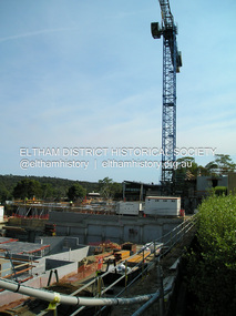
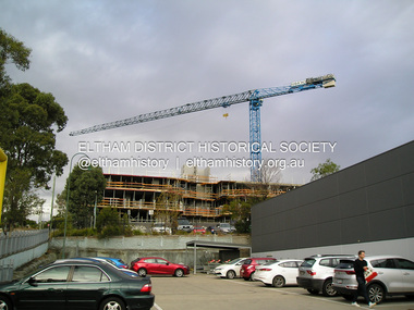
Photograph, Fay Bridge, The Canopy appartments under construction, Pryor Street, Eltham, 10 March 2019
First time a crane has ever been used for appartment construction in Eltham. The crane was illuminated at night and at times parked overhanging the roadfay bridge collection, 2019-03-10, eltham, eltham activity centre, pryor street, safeway supermarket, the canopy, woolworths -
 Eltham District Historical Society Inc
Photograph, Fay Bridge, The Canopy appartments under construction, Pryor Street, Eltham, 31 March 2019
First time a crane has ever been used for appartment construction in Eltham. The crane was illuminated at night and at times parked overhanging the roadfay bridge collection, eltham, eltham activity centre, pryor street, safeway supermarket, the canopy, woolworths, 2019-03-31 -
 Eltham District Historical Society Inc
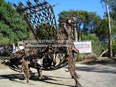
Photograph, Fay Bridge, Scrap iron sculpture outside St Andrews Stockfeed, 66 Caledonia St, St Andrews, 31 March 2019
fay bridge collection, 2019-04-07, art, caledonia street, click here to add keywords, sculpture, st andrews, st andrews road, st andrews stockfeed -
 Eltham District Historical Society Inc
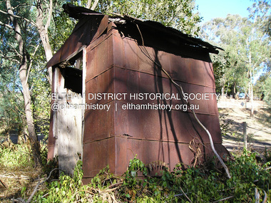
Photograph, Fay Bridge, Old outhouse constructed from recycled materials on a private property on way to St Andrews, 17 April 2019
Vacuum Oil Company https://en.wikipedia.org/wiki/Vacuum_Oil_Company Henry Bamford and Sons Uttoxeter, England https://henrybamfordandsonsuttoxeterengland.co.uk/1931-1945/fay bridge collection, 2019-04-17, bamford stationary engine, england, pump, st andrews, the bamford diesel, uttoxeter, vacuum oil company pty ltd -
 Eltham District Historical Society Inc
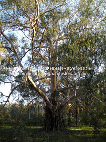
Photograph, Fay Bridge, Yellow Box Gum tree near junction of Main Yarra Trail and Mullum-Mullum Trail, Templestowe, 7 July 2019
Situated in the wetlands on the trail opposite the Pontville Homestead, former home of Major Charles Newman and across the Yarra River from Sweeneys Flats, Eltham. Newman also purchased Allotment 5, Section 2 (in Ely Street, Eltham) at public autction on 17 September 1851. It was the only Section 2 allotment purchased at the firts Elthan Town Allotments public auction.fay bridge collection, sweeneys flats, 2019-07-07, major charles newman, mullum mullum creek, pontville homestead, significant tree, yellow box gum (eucalyptus melliodora)