Showing 2091 items
matching bendigo maps
-
 Bendigo Historical Society Inc.
Ephemera - LYDIA CHANCELLOR COLLECTION: TRAVEL BROCHURES
A decorated cardboard box containing travel brochures, passenger lists and a map of Scotland. Also contains a letter to Grandma from Mary and George, dated 1st July, 1963, telling of their trip around Scotland.Mary, George travel letterplace, lydia chancellor, collection, letters, correspondance, communication, travel brochures, tourism, place, scotland, map, passenger list, ephemera -
 Bendigo Historical Society Inc.
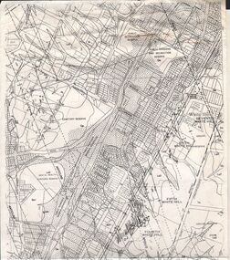
Map - VICTORIA HILL - MAP - HAPPY VALLEY RD - DARE ST
... Inc. History House 11 Mackenzie Street Bendigo goldfields MAP ...Small map showing some blocks of land in the Happy Valley Road, Dare Street and Wells Streets area. Three of the blocks are in the name of Rae.map, bendigo, victoria hill, victoria hill, victoria hill - map - happy valley road - dare street, w rae, j rae -
 Bendigo Historical Society Inc.
Medal - MEDAL COLLECTION: PROMOTE FEDERATION MEDAL, 1899
Object. Brass coloured medal with 1.5 mm hole drilled near top edge. Obverse:Australian Coat of Arms. Kangaroo and emu have their heads turned. Engraved around edge. ''Promote Federation & Prosperity'', Underneath Coat of Arms ''1899''. Reverse: Laurel leaves around the edge. Map of Australia in the centre with ''1899''. Engraved around map ''Australia's Commonwealth''.numismatics, badges-commemorative, promote federation medal1899 -
 Bendigo Historical Society Inc.
Document - MCCOLL, RANKIN AND STANISTREET COLLECTION: INDENTURE GOLD MINING LEASE 9201 BALLAARAT
6 page document plus map: indenture, gold mining lease dated 9th August 1960, between the Crown and North Deborah Mining Company, carrying on operations in the Parish of Moorarbool West . Key on map indicates depth to which land may be excised. On map: Mining District of Ballarat, County of Grant, Parish of Moorarbool West. Total area: 285 acres 1 rood, 20 perches. Vol 334, Fol 202.bendigo, mining, deborah gold mines -
 Bendigo Historical Society Inc.
Document - MCCOLL, RANKIN AND STANISTREET COLLECTION: INDENTURE GOLD MINING LEASE 11012 CROWN AND NORTH DEBORAH MINING COMPANY, 3rd June to 13th Nov 1939
6 page document plus map: indenture No. 11012, Gold Mining Lease, between Crown and North Deborah Mining Company carrying on operations in the Parish of Sandhurst, dated 3rd June, 1939. Map shows land excised for mining in pink and Crown land in orange cross-hatching . Streets shown: Queen Street, King Street, Hargreaves Street, Breen Street. Leases: No's. 10939, 1363 TL, 11012, 10937, Railway line through centre of lease holding. On last page 'Deborah Gold Mines No Liability of 125 queen Street Melbourne is now the proprietor of the within described estate by transfer registered on 13th November, 1939 and numbered 1752584'.bendigo, mining, north deborah mining company, j sweeney, common seal of north deborah mining company, stanistreet, breen street, king street, queen street, hargreaves street. -
Bendigo Historical Society Inc.
Book - SOUVENIR OF MY SECOND TOUR OF THE WORLD 1924, 1925
My Second Tour of the World. 1924. By G.A. Pethard Printed by The Cambridge Press, Bendigo. 1925. Includes b/w photographs and a handrawn map. Travel book to "...afford much information on subjects and places not generally known and help readers to better appreciate the marvels of other lands'' (taken from the preface) Countries visited: Ceylon (Sri Lanka) India Malaya (Malaysia) Batavia, Java (Indonesia) China Hong Kong Japan Manchuria (China and Russia) Siberia (Russia) Russia Finland Sweden Norway England (England and Scotland and Wales) Teneriffe (Canary Islands, Spain) South Africa (South Africa and Zimbabwe) Item note: With the author's compliments... [handwritten] Mr J. Thomas, Golden Square As the pages are not numbered, it is uncertain if any pages are missing from the front of the book. The first page talks about Ceylon. It makes no mention of Fremantle. However, Fremantle is noted on the map. 3 copiesG. A. Pethardbiography, highlights of a world tour. -
 Bendigo Historical Society Inc.
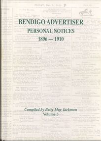
Book - BENDIGO ADVERTISER PERSONAL NOTICES 1896 - 1910
... Volume 3 some black and white photographs & a map. Book BENDIGO ...Hardcover book with 504 pages of personal notices published in the Bendigo Advertiser 1896 - 1910 compiled by Betty May Jackman Volume 3 some black and white photographs & a map.Betty May Jackmanbooks, catalogues, personal notices -
 Bendigo Historical Society Inc.
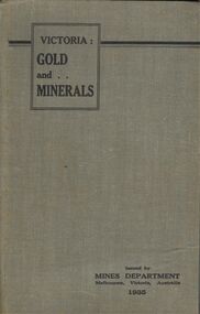
Book - BOOK - VICTORIA: GOLD AND . . MINERALS
A copy of the 1935 guide book Victoria: GOLD and MINERALS . This book gives in great detail about promising mining areas in Victoria along with detailed maps of them.book, bendigo, mining -
 Bendigo Historical Society Inc.
Document - FOSTERVILLE GOLD MINE COLLECTION: OPEN DAY 2018
2 page document, coloured, titled 'Kirkland Lake Gold' and 'Welcome to the Fosterville Gold Mine Open Day 2018'. Document describes activities available to visitors on the 2018 Open Day, and a map of the mine site showing location of various displays.bendigo, mining, fosterville gold mine -
 Bendigo Historical Society Inc.
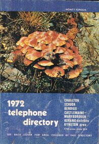
Book - BOOK - 1972 TELEPHONE DIRECTORY
... of the local flora.The back cover features of a map of the Bendigo Area.... of the local flora.The back cover features of a map of the Bendigo Area ...A copy of the 1972 Telephone Directy for Charlton, Echuca, Bendigo, Castlemaine, Maryborough, Kerang Districts, Kyneton area. The book is blue with a unique pattern and has a picture of the local flora.The back cover features of a map of the Bendigo Area.book, rural -
 Bendigo Historical Society Inc.
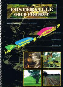
Document - FOSTERVILLE GOLD MINE COLLECTION: FOSTERVILLE GOLD PROJECT UPGRADE EXECUTIVE SUMMARUY
Black cover book, wire binding, 13 pages of text and maps. On front: Fosterville Gold Project' Map of ore body on cover - Central North, Central Ellesmere, Harringtons Hill. Contents include: open pits, heap leaching, waste dumps, estimated project life, changes from previously approved project, estimated project life, main project components, expanded open pits and underground mines, processing sulphide ore, tailings storages, waste rock dumps. Principles of rehabilitation, site preparation, rehabilitation activities during operation and decommissioning activities. Environmental issues, and summary of proposed new operating conditions.bendigo, mining, fosterville gold mine -
 Bendigo Historical Society Inc.
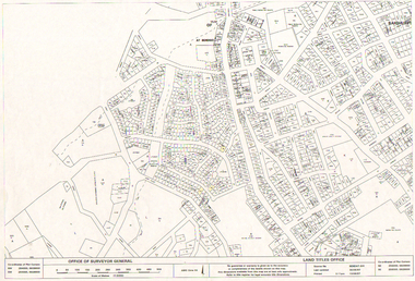
Map - LONG GULLY HISTORY GROUP COLLECTION: LONG GULLY AREA
Copy of a map showing streets and allotments in the Long Gully area, last updated 30/05/97, printed 19/06/97. Made by the Land Titles Office. Some street names, reserves and allotment numbers are printed on the map.bendigo, history, long gully history group, the long gully history group - long gully area, land titles office, office of surveyor general, city of bendigo, shire of marong, state electricity commission -
 Bendigo Historical Society Inc.
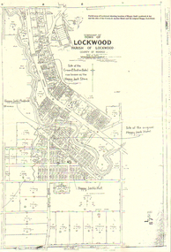
Map - LONG GULLY HISTORY GROUP COLLECTION: LOCKWOOD TOWNSHIP
... Happy Jack Store County of Bendigo Copy of a map of Township ...Copy of a map of Township of Lockwood, County of Bendigo. Printed at the top of the map is: Parish map of Lockwood showing location of Happy Jack's paddock & hut and the sites of the Crown & Anchor Hotel and the original Happy Jack Hotel. Written on the map with arrows pointing to the site is: Happy Jack's Paddock, Site of the original Happy Jack Hotel and Happy Jack's Hut. An outline of Happy Jack's Paddock is drawn in.bendigo, history, long gully history group, the long gully history group - lockwood township, crown & anchor hotel, happy jack hotel, happy jack store, county of bendigo -
 Bendigo Historical Society Inc.
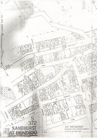
Map - LONG GULLY HISTORY GROUP COLLECTION: SANDHURST AT BENDIGO
... Copy of a map titled Sandhurst at Bendigo, Parish... Group - Sandhurst at Bendigo Copy of a map titled Sandhurst ...Copy of a map titled Sandhurst at Bendigo, Parish of Sandhurst, County of Bendigo. Some of the street names are: Quick, Rae, Casley, Bell. Thomas, Victoria, Roeder and Prout Streets. Allotments have the date, size, measurements and names on them. Some are unreadable.bendigo, history, long gully history group, the long gully history group - sandhurst at bendigo -
Bendigo Historical Society Inc.
Map - LONG GULLY HISTORY GROUP COLLECTION: LONG GULLY
Copy of a map of Long Gully area with some street names, size of allotments, number, measurements, date and names.bendigo, history, long gully history group, the long gully history group - long gully, housing commission, housing act 1958, gazette -
 Bendigo Historical Society Inc.
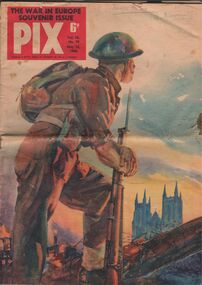
Magazine - AILEEN AND JOHN ELLISON COLLECTION: PIX, THE WAR IN EUROPE SOUVENIR ISSUE 1945
Pix magazine volume 15 no. 19 May 12, 1945. The war in Europe souvenir issue. The magazine has 31 pages, price 6 pennies. Features in this issue: Britain faced Hitler alone in 1940 - Many races united against common enemy - Allied leaders' words inspired their nations - Color maps reveal changing face of Europe - Picture diary shows five year pattern of war - Jardine paints second front landing in colors - Rise and fall of fascism - Women shared role in fight for freedom - Danger of armistice in Europe - War closes in on Japan, Pacific color map - Proud records of Australia's fighting men - Four great powers shared burden of struggle - World found time too laugh at war - Famous pictures epitomised war's tragedy.books, magazines, war in europe -
 Bendigo Historical Society Inc.
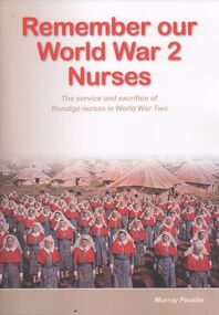
Book - REMEMBER OUR WORLD WAR 2 NURSES
Soft covered book, Remember our World War 2 Nurses, the service and sacrifice of Bendigo nurses in World War Two, 150 pages with black and white photographs & maps, researched and written by Murray Poustie, published by the Northern District School of Nursing Graduates Association Inc, printed in Bendigo by Bendigo Modern Press.Murray Poustiebooks, military, nursing, bendigo-nursing-ww2 -
 Bendigo Historical Society Inc.
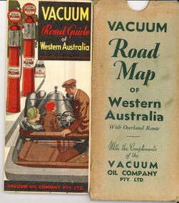
Document - BILL ASHMAN COLLECTION: VACUUM ROAD MAP WESTERN AUSTRALIA
... Inc. History House 11 Mackenzie Street Bendigo goldfields MAP ...Vacuum Road Map of Western Australia with overland route with the compliments of the Vacuum Oil Company Pty Ltd.map -
 Bendigo Historical Society Inc.
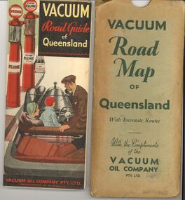
Document - BILL ASHMAN COLLECTION: VACUUM ROAD MAP QUEENSLAND
... Inc. History House 11 Mackenzie Street Bendigo goldfields MAP ...Vacuum Road Map of Queensland with Interstate routes with the compliments of the Vacuum Oil Company Pty Ltd.map -
 Bendigo Historical Society Inc.
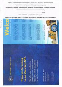
Document - FOSTERVILLE GOLD MINE COLLECTION: OPEN DAY 2019
Two page document for Kirkland Lake Gold Open day 2019. Open Day activities include: bus tours, technical services display, geology, exploration, processing, community and environment display, minerals council of Australia, Swick drilling, Central Deborah Gold Mine, Face painting, Goldfields Re-vegetation, Delecca's hire equipment, MacMahon underground mining services, Sandvik, and ISH24 safety specialists. Map of 'Fosterville Gold Mine Site Map' with activities highlighted. Fosterville is Victoria's larges gold producer and in 2918 a records 356,230 ounces at an average grade of 24.9 g per tonne. The mine has over 600 full time employees in 2019. Entry for '9 levels of darkness' tour at Central Deborah Mine attached.bendigo, mining, fosterville gold mine -
 Bendigo Historical Society Inc.
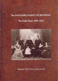
Book - FAVALORO COLLECTION: THE FAVALORO FAMILY OF BENDIGO, 1895 - 1942
Hard covered book, The Favaloro Family Of Bendigo, The Early Years 1895 - 1942, 324 pages with black & white photographs, coloured photographs and maps, printed 7 bound in Australia by Focus print Group Keysborough Vic. Bound in reddish brown leather look with a group photograph of the Favaloro family 1908 on front, a thank you note from the Author enclosed.Robert McWilliamsbook, bendigo, favaloro, bendigo-history-favaloro-buildings-cafes -
 Bendigo Historical Society Inc.
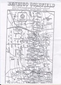
Document - CONSTABLE RYAN COLLECTION: MAP OF BENDIGO GOLDFIELD
... CONSTABLE RYAN COLLECTION: MAP OF BENDIGO GOLDFIELD...A copy of a map of the Bendigo Goldfields showing reef... Inc. History House 11 Mackenzie Street Bendigo goldfields MAP ...A copy of a map of the Bendigo Goldfields showing reef lines.map, bendigo, goldfields -
 Bendigo Historical Society Inc.
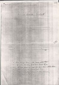
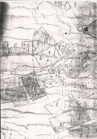
Document - CONSTABLE RYAN COLLECTION: HAND DRAWN MAP OF AREA OF CONSTABLE RYAN DISAPPEARANCE
An hand drawn map of the area of constable Ryan disappearance. The map is not to scale.document -
 Bendigo Historical Society Inc.
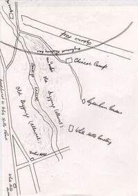
Document - CONSTABLE RYAN COLLECTION: MAP OF CHINESE CAMP IRONBARK
A photocopy of a small section of the Chinese Camp, Ironbark showing houses and spot relevant to the disappearance of constable Ryan.document -
 Bendigo Historical Society Inc.
Document - CONSTABLE RYAN COLLECTION: MAP OF NORTH BENDIGO SHOWING CHINA CO. MINING LEASE
... CONSTABLE RYAN COLLECTION: MAP OF NORTH BENDIGO SHOWING...Bendigo Historical Society Inc. Bendigo Historical Society ...Map scale 1:5000 showing where the China Co. gold mining lease was.document -
 Bendigo Historical Society Inc.
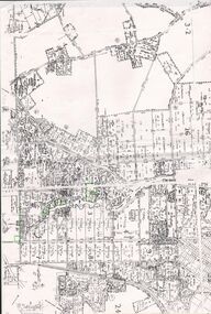
Document - CONSTABLE RYAN COLLECTION: MAP OF WHITE HILLS
... Inc. History House 11 Mackenzie Street Bendigo goldfields MAP ...Map of White Hills.map, bendigo, white hills -
 Bendigo Historical Society Inc.
Document - CONSTABLE RYAN COLLECTION: MAP OF NORTH BENDIGO CHINESE CAMP
... CONSTABLE RYAN COLLECTION: MAP OF NORTH BENDIGO CHINESE... Inc. History House 11 Mackenzie Street Bendigo goldfields MAP ...Photocopy of a map showing various mining leases around North Bendigo. The photocopy is not of a very good quality.map, bendigo, north bendigo -
 Bendigo Historical Society Inc.
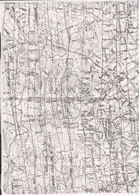
Document - CONSTABLE RYAN COLLECTION: LINES OF REEFS OF BENDIGO FIELD
... Inc. History House 11 Mackenzie Street Bendigo goldfields MAP ...Photocopy of a map showing the lines of reefs of Bendigo goldfields.map, bendigo, goldfields -
 Bendigo Historical Society Inc.
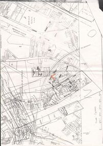
Document - CONSTABLE RYAN COLLECTION: PLANS HIGHLITING PROPERTIES CONNECTED TO CASE
... Inc. History House 11 Mackenzie Street Bendigo goldfields MAP ...Details plans of particular properties connected to the case.map, bendigo -
 Bendigo Historical Society Inc.
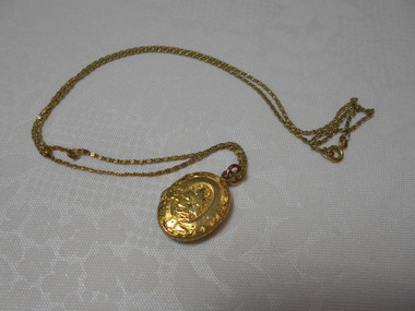
Accessory - HOSKING AND HUNKIN COLLECTION: GOLD LOCKET, 1900
Object. Oval shaped gold locket on fine gold chain. Inside locket are two locks of hair. Accompanying note states- "22ct Gold c1900 unsure - could be older". One side of locket has embossed flower. Other side has map of Australia. Accompanying note "Gold locket belonged to Emily Lawry (nee Hunkin), grand-daughter of William and Emblen Hosking. Hair in locket is unknown. Emily Lawry born at Nerring near Eaglehawk. Betty Knight is grand-daughter of Emily Lawry. By the time she received the locket her grandmother had died.costume accessories, jewellery, gold locket