Showing 4357 items
matching history - wars
-
 Surrey Hills Historical Society Collection
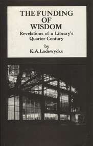
Book, Spectrum Publications, The Funding of Wisdom: Revelations of a Library's Quarter Century, 1982
The author lived locally. 361p; This book deals principally with experience after the second world war in an environment of tertiary education. It testifies to the unprecedented pressures imposed on such resources by the "information explosion" which accompanied the phenomenal developments in education, science and industry. Title page: signed by the author: Axel Lodewycks Front Endpaper: Book given to me by /Axel as I spoke to him / about his life & home in / Mont Albert and the the Bull / family and Medlow. / 1985 & 1990 / J F Hall361p; This book deals principally with experience after the second world war in an environment of tertiary education. It testifies to the unprecedented pressures imposed on such resources by the "information explosion" which accompanied the phenomenal developments in education, science and industry.Title Page: signed by the author, Axel Lodewyeks. Front end paper: Book given to me by / Axel as I spoke to him / about his life & home in / Mont Albert and the Bull / family and Medlow. / 1985 & 1990 / J F Hall(mr) karel axel lodewycks, university of melbourne - library - history, college librarians - victoria - melbourne, baillieu library, world war- 1939-1945, (mrs) jocelyn f hall -
 Surrey Hills Historical Society Collection
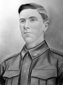
Photograph, Robert Gray, grandson of Robert Beckett
The pencil sketch from which this photo was taken had been hidden from view from 1919 - 1996 when it was located behind a framed photo retrieved from the Surrey Hills Bowling Club at the time of its closure. The sketch had been used as backing when photo framed in 1919. Jocelyn Hall gave the original to great nephew, [name TBC], who was a pharmacist at the Mont Albert tram terminus at the time. Initially the subject's identity was not known. A scribbled name 'Walduck' on a different photo finally resulted in the identification as John Robert Gray, who died 1917. He was engaged at the time of enlistment and after his death his fiancee did not marry. He attended Surrey Hills Primary School and was a salesman at the time of enlistment on 9 May 1916. He embarked from Melbourne on board HMAT A60 Aeneas on 3 October 1916. His AIF papers list his mother as his next of kin, both resident in Suffolk Road, Surrey Hills. He was a gunner in the Howitzer Brigade 120. He was Killed in Action on 21 June 1917 and was buried at Bapaume Australian Cemetery (Row C, Grave NO. 5), France. It is believed that the sketch was made prior to him going overseas to France. John Robert Gray was the eldest son of Emma (nee Beckett) and John Gray. His father John Gray was "actively associated with all movements for the benefit of neighbours and fellow citizens". [Quote from the official tribute on his death in 1909.] He was very active in the Surrey Hills Progress Association in the early 1900's. The rotunda built in the Surrey Gardens by the Progress Association in 1912 was dedicated to him. He married Emma Beckett in 1888 at 'Guildford Villa' in Essex Road, the Beckett home. They are listed in both the 1903 and 1906 electoral rolls in Arundel Crescent; his occupation is given as bootmaker. The Alan Holt property register identifies this as 24 Arundel Crescent, known as 'Tumberumba'. John and Emma had a large family: (Gunner) John Robert Gray (1888, Surrey Hills - 21 June 1917, France) Benjamin Walter Gray (1890, Surrey Hills - 1949, Heidelberg) Herbert Harry Gray (1892, Surrey Hills - 1959, Queensland) William Beckett Gray (1897, Surrey Hills - 1899, Surrey Hills) Norman Douglas Gray (1901, Surrey Hills - 1947, Sydney) Evelyn Lizzie Gray (1906, Surrey Hills - 1983) Evelyn married Reginald Roberts and donated a number of photos to the collection. Both the Beckett and the Gray families were important in the early history of Surrey Hills. This is the only known image of John Robert Gray in WW1 uniform.A black and white photo of a hand-drawn image of a young man in uniform.world war, 1914-1918, (mrs) emma gray, (miss) emma beckett, (mr) john gray, walduck family, (mr) john robert gray, (mr) robert gray, world war, 1914-1919, surrey hills bowling club, bapaume australian cemetery, france -
 8th/13th Victorian Mounted Rifles Regimental Collection
Photograph
Four men who served as National Servicemen in differing eras of Australian military history : 1929, 1939, 1957, & 1968national service, military, wwii, world war two, vietnam -
 8th/13th Victorian Mounted Rifles Regimental Collection
Booklet - History 20 LH
The 20th Light Horse (Victorian Mounted Rifles) was raised in 1920 as part of the 3rd Cavalry Brigade, 2nd Cavalry Division, Citizen Military Forces, with Headquarters at Seymour and depots along the Goulburn Valley from Mansfield to Tocumwal in southern NSW. In December 1941, 20th Light Horse (Victorian Mounted Rifles) converted from horse to mechanised, initially as 20th Motor Regiment. In 1943 the Regiment was deployed to Merauke, Dutch New Guinea. Upon its return in April 1945, the Regiment was redesignated 20th Pioneer Battalion. It was disbanded following the end of the war. 20th Light Horse was the only light horse regiment to serve overseas in WWII.A4 sized booklet with stiff slip-on plastic spine, 16 pages, clear plastic front cover and card back cover. Covers the history of the regiment from Victorian Colonial period, Federation militia as 7th, 15th and finally 20th Light Horse, then conversion to 20 Motor Regiment and deployment to Merauke in Dutch New Guinea and lastly in the closing stages of the Second World War to 20th Pioneer Battalion.military, wwii, world war two, light horse, motor regiment, pioneer battalion, aif, merauke, new guinea -
 8th/13th Victorian Mounted Rifles Regimental Collection
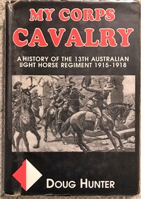
Book - My Corps Cavalry
The book was launched at Buna Barracks Albury 1999 by Hon Tim Fischer Deputy Prime Minister.Hardback book titled "My Corps Cavalry: history of the 13th Australian Light Horse" by Doug Hunter 1999.Signed on fly leaf by author and launcher13th, light horse, book, cavalry, world war one, wwi -
 8th/13th Victorian Mounted Rifles Regimental Collection
Pamphlet - McGrath & Austin
William McGrath enlisted as a Trooper in the 8th Light Horse in 1915. He rose to the rank of Squadron Sergeant Major and was commissioned as a Second Lieutenant on Gallipoli. McGrath served throughout the war with 8th Light Horse Regiment progressing through the officer ranks. As adjutant, he compiled a history of the regiment both from personal knowledge and the regiment's war diary. McGrath's successor as adjutant, Captain Austin, is believed to have had input into the document and for some years was thought to have been the originator. The 8th Light Horse Regiment AIF was raised at Broadmeadows Victoria in September 1914 under the command of Lieutenant Colonel Alexander White and formed part of the 3rd Light Horse Brigade. The regiment served at Gallipoli where in a courageous but ill-fated charge at the Nek on 7 August 1915 it suffered horrendous casualties including Lieutenant Colonel White. Rebuilt in Egypt under the command of Lieutenant Colonel Leslie Maygar VC the regiment went on the serve throughout the Middle East Campaign. Colonel Maygar died of wounds at Beersheba when the regiment was attacked by enemy aircraft while waiting to follow up the successful charge of the 4th LH Brigade on 30 October 1917. The 8th Light Horse AIF was disbanded in 1919, but soon after re-raised as the 8th (Indi) Light Horse in the Citizen Military Forces, superseding 16th (Indi) Light HorseBlack and white photograph of two 8th Light Horse officers ; Captains McGrath (left) and Austin. Photograph is glued to fluted plastic board.mcgrath, austin, 8th light horse, world war one, wwi -
 8th/13th Victorian Mounted Rifles Regimental Collection
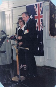
Photograph - Launch My Corps Cavalry
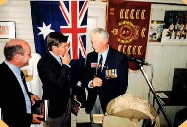
"My Corps Cavalry: a history of the 13th Australian Light Horse" was written by Lieutenant Colonel Douglas Hunter (Retired) and launched by Deputy Prime Minister Hon Tim Fischer. Tim Fischer served with 1st Battalion Royal Australian Regiment; Doug Hunter served with 8/13 Victorian Mounted Rifles. The 13th Light Horse Regiment (AIF) was raised at Broadmeadows Victoria in March 1915. Following service at Gallipoli the regiment was broken up with squadrons going to France as Divisional Cavalry Squadrons of 2nd, 4th and 5th Divisions. The regiment was reformed as firstly 1st Anzac Corps Mounted Troops and later Australian Corps Mounted Troops.Colour photograph of Hon Tim Fischer speaking at the launch of the book "My Corps Cavalry: history of the 13th Australian Light Horse at Buna Barracks Albury 13 March 1999.13th, light horse, world war one, wwi, fischer, hunter, book -
 8th/13th Victorian Mounted Rifles Regimental Collection
Photograph - Launch My Corps Cavalry
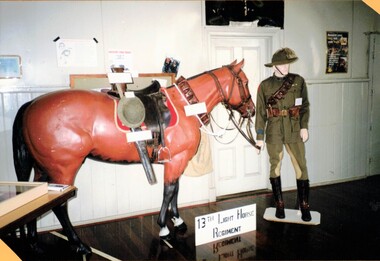
"My Corps Cavalry: a history of the 13th Australian Light Horse" was written by Lieutenant Colonel Douglas Hunter (Retired) and launched by Deputy Prime Minister Hon Tim Fischer. Tim Fischer served with 1st Battalion Royal Australian Regiment; Doug Hunter served with 8/13 Victorian Mounted Rifles. The 13th Light Horse Regiment (AIF) was raised at Broadmeadows Victoria in March 1915. Following service at Gallipoli the regiment was broken up with squadrons going to France as Divisional Cavalry Squadrons of 2nd, 4th and 5th Divisions. The regiment was reformed as firstly 1st Anzac Corps Mounted Troops and later Australian Corps Mounted Troops.Colour photograph of display of light horseman and horse of the 13th Australian Light Horse prepared for the launch of the book "My Corps Cavalry: history of the 13th Australian Light Horse", at Buna Barracks Albury 13 March 1999.13th, light horse, world war one, wwi, fischer, hunter, book -
 8th/13th Victorian Mounted Rifles Regimental Collection
Photograph - Launch My Corps Cavalry
"My Corps Cavalry: a history of the 13th Australian Light Horse" was written by Lieutenant Colonel Douglas Hunter (Retired) and launched by Deputy Prime Minister Hon Tim Fischer. Tim Fischer served with 1st Battalion Royal Australian Regiment; Doug Hunter served with 8/13 Victorian Mounted Rifles. The 13th Light Horse Regiment (AIF) was raised at Broadmeadows Victoria in March 1915. Following service at Gallipoli the regiment was broken up with squadrons going to France as Divisional Cavalry Squadrons of 2nd, 4th and 5th Divisions. The regiment was reformed as firstly 1st Anzac Corps Mounted Troops and later Australian Corps Mounted Troops.Colour photograph of RAAC Historian Major Paul Handel (Retired), Major John Baines and Lieutenant Colonel Doug Hunter (Retired) at the launch of the book "My Corps Cavalry: history of the 13th Australian Light Horse at Buna Barracks Albury 13 March 1999.13th, light horse, world war one, wwi, hunter, book, baines, handel -
 8th/13th Victorian Mounted Rifles Regimental Collection
Document - 13th LH History
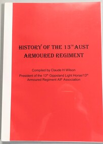
The 10th Light Horse was raised in 1903 from Victorian Mounted Rifles companies in Gippsland. In 1912 the regiment was renumbered 13th Light Horse. In 1920 the regiment had the territorial title Gippsland Light Horse added. The regiment was raised as 13th Light Horse (Gippsland), a Citizen Forces unit. In 1940 the regiment converted from horse to mechanised, initially as 13th Motor Regiment then 13th Armoured Regiment. It trained in Victoria and Queensland but as the Japanese threat to the mainland declined, was disbanded in October 1943 with men going to other units. The 13th Light Horse Regiment (AIF) was raised at Broadmeadows Victoria in March 1915. Following service at Gallipoli the regiment was broken up with squadrons going to France as Divisional Cavalry Squadrons of 2nd, 4th and 5th Divisions. The regiment was reformed as firstly 1st Anzac Corps Mounted Troops and later Australian Corps Mounted Troops.History of 13th Armoured Regiment and its preceding regiments 10th Light Horse (VMR), 13th Light Horse (VMR), 13th Light Horse (AIF) and 13th Light Horse (Gippsland Light Horse) compiled by the President of the regimental association, Claude H Wilson c.1970. The text is handwritten and includes the World War diary of lieutenant Vernon C Walker, who was a member of the AIF regiment. A4 format, thermal bound 27 pages with 6 page addendum.history, light horse, armour, 13th, gippsland, wilson, walker -
 8th/13th Victorian Mounted Rifles Regimental Collection
Book, The New Guinea Campaign 1941-43
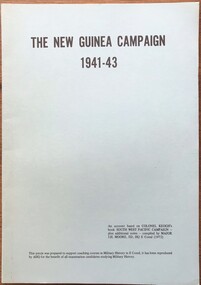
... prepared for officers studying for a military history promotion ...A series of study notes covering the military campaign in Papua and New Guinea during the Second World War.Green soft covered booklet, 28 pages double sided printing, thermal binding.non-fictionA series of study notes covering the military campaign in Papua and New Guinea during the Second World War.wwii, new guinea, papua, world war two, moore, history -
 8th/13th Victorian Mounted Rifles Regimental Collection
Book, The Malayan Campaign 1941-42
... . Booklet prepared for officers studying for a military history ...A series of study notes covering the military campaign in Malaya during the Second World War.Green soft covered booklet, 42 pages, fold out appendix, two maps, thermal binding.non-fictionA series of study notes covering the military campaign in Malaya during the Second World War.wwii, world war two, moore, history, malaya -
 8th/13th Victorian Mounted Rifles Regimental Collection
Book, An introduction to the study of the principles of war
... of the principles of war drawing on examples from history. ...An introduction lecture to the study of the principles of war drawing on examples from history.Green soft covered booklet, 22 pages, thermal binding.non-fictionAn introduction lecture to the study of the principles of war drawing on examples from history.history, principles, war, macklin -
 8th/13th Victorian Mounted Rifles Regimental Collection
Book, The Burma Campaign
... J H Moore 1972. WWII World War Two Moore history Burma ...A series of study notes covering the military campaign in Burma during the Second World War.Green soft covered booklet, 93 pages, maps and diagrams,, thermal binding.non-fictionA series of study notes covering the military campaign in Burma during the Second World War.wwii, world war two, moore, history, burma -
 8th/13th Victorian Mounted Rifles Regimental Collection
Book, Tanks against Japan
... February 1968. WWII New Guinea Papua World War Two history Graham ...A series of study notes covering the military campaign in Papua and New Guinea during the Second World War.Green soft covered booklet, 46 pages, compressed plastic binding strip.non-fictionA series of study notes covering the military campaign in Papua and New Guinea during the Second World War.wwii, new guinea, papua, world war two, history, graham, japan, tank, india, burma, borneo -
 8th/13th Victorian Mounted Rifles Regimental Collection
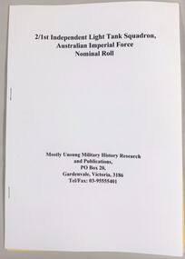
Book - Roll 2/1st Light Tank
Published by Mostly Unsung Military History Research.Soft cover booklet, " 21st Independent Light Tank Squadron, Australian Imperial Force Nominal Roll " Six pages,staple boundtank, roll, wwii, world war two, aif -
 Kew Historical Society Inc
Plan - Subdivision Plan, Plan of Subdivision of Part of Crown Portion 84 / Parish of Boroondara / County of Bourke / Lodged Plan No. 2217, Twentieth Century
Pru Sanderson, in her groundbreaking ‘City of Kew Urban Conservation Study : Volume 2 - Development History’ (1988), summarised the periods of urban development and subdivisions of land in Kew. The periods that she identified included 1845-1880, 1880-1893, 1893-1921, 1921-1933, 1933-1943, and Post-War Development. These periods were selected as they represented periods of rapid growth or decline in urban development. An obvious starting point for Sanderson’s groupings involved population growth and the associated economic cycles. These cycles also highlighted urban expansion onto land that was predominantly rural, although in other cases it represented the decline and breakup of large estates. A number of the plans in the Kew Historical Society’s collection can also be found in other collections, such as those of the State Library of Victoria and the Boroondara Library Service. A number are however unique to the collection.The Kew Historical Society collection includes almost 100 subdivision plans pertaining to suburbs of the City of Melbourne. Most of these are of Kew, Kew East or Studley Park, although a smaller number are plans of Camberwell, Deepdene, Balwyn and Hawthorn. It is believed that the majority of the plans were gifted to the Society by persons connected with the real estate firm - J. R. Mathers and McMillan, 136 Cotham Road, Kew. The Plans in the collection are rarely in pristine form, being working plans on which the agent would write notes and record lots sold and the prices of these. The subdivision plans are historically significant examples of the growth of urban Melbourne from the beginning of the 20th Century up until the 1980s. A number of the plans are double-sided and often include a photograph on the reverse. A number of the latter are by noted photographers such as J.E. Barnes.Undated Plan of Subdivision of Crown Portion 84 in what is now Kew. The area shown is bordered by Burke Road, Harp Road, Arglye Road and Normanby Road.subdivision plans -- kew (vic), harp road, burke road, normanby road, lady loch's drive, gladstone street, second avenue, first avenue -
 Kew Historical Society Inc
Book, Oxford University Press, The Narrative of George Russell of Golf Hill with Russelliana and selected papers, 1963
Account of early pastoral settlement in Tasmania and Port Phillip focusing on the progress of the Russell family; includes observations on relations between settlers and Aborigines; account of the Black War in Tasmania; story of William Buckley, description of Port Phillip Aboriginal shelters, corroborees, missions, rapid extinction.London : Oxford University Press, 1935 469 p. : ill. map, ports., geneal. table ; 25 cm. non-fictionAccount of early pastoral settlement in Tasmania and Port Phillip focusing on the progress of the Russell family; includes observations on relations between settlers and Aborigines; account of the Black War in Tasmania; story of William Buckley, description of Port Phillip Aboriginal shelters, corroborees, missions, rapid extinction.russell family, clyde company, voyages and travels -
 Kew Historical Society Inc
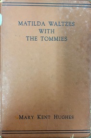
Book, Oxford University Press, Matilda Waltzes with the Tommies, 1944
Melbourne : Oxford University Press, 1943 176 p. : ill., ports. ; 22 cm. non-fictionkent hughes, mary, world war 1939-1945 -- personal narratives -
 Kew Historical Society Inc
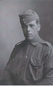
Photograph - Photograph [copy], Pte. Charles Field Richardson, 1914
This work forms part of the collection assembled by the historian Dorothy Rogers, that was donated to the Kew Historical Society by her son John Rogers in 2015. The manuscripts, photographs, maps, and documents were sourced by her from both family and local collections or produced as references for her print publications. Many were directly used by Rogers in writing ‘Lovely Old Homes of Kew’ (1961) and 'A History of Kew' (1973), or the numerous articles on local history that she produced for suburban newspapers. Most of the photographs in the collection include detailed annotations in her hand. The Rogers Collection provides a comprehensive insight into the working habits of a historian in the 1960s and 1970s. Together it forms the largest privately-donated collection within the archives of the Kew Historical Society.A half length portrait of Charles Richardson, the brother of the historian Dorothy Rogers, who enlisted in 1914. Pte. Charles Field Richardson fought and was wounded at Gallipoli. He died of his wounds in Alexandria after being wounded at Gallipoli.pte. charles field richardson, charles richardson, world war one -
 Kew Historical Society Inc
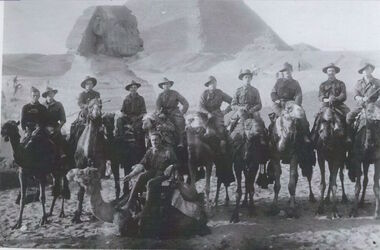
Photograph - Photograph [copy], Australian soldiers in Egypt, 1914
Charles Field Richardson was the brother of Kew historian Dorothy Rogers. He died at Alexandria after being wounded at Gallipoli. This work forms part of the collection assembled by the historian Dorothy Rogers, that was donated to the Kew Historical Society by her son John Rogers in 2015. The manuscripts, photographs, maps, and documents were sourced by her from both family and local collections or produced as references for her print publications. Many were directly used by Rogers in writing ‘Lovely Old Homes of Kew’ (1961) and 'A History of Kew' (1973), or the numerous articles on local history that she produced for suburban newspapers. Most of the photographs in the collection include detailed annotations in her hand.The Rogers Collection provides a comprehensive insight into the working habits of a historian in the 1960s and 1970s. Together it forms the largest privately-donated collection within the archives of the Kew Historical Society.Australian soldiers at the pyramids of Egypt before departure for Gallipoli. One of them is Charles Field Richardson, Regimental Number 341, 6th Battalion, Australian Imperial Forces. Charles Richardson far leftcharles field richardson, dorothy rogers, world war 1, australian soldiers, egypt, pyramids, sphinx, gallipoli, charles richardson, camel -
 Kew Historical Society Inc
Plan, Studley Park Estate, 1910
Prue Sanderson, in her groundbreaking ‘City of Kew Urban Conservation Study : Volume 2 - Development History’ (1988), summarised the periods of urban development and subdivisions of land in Kew. The periods that she identified included 1845-1880, 1880-1893, 1893-1921, 1921-1933, 1933-1943, and Post-War Development. These periods were selected as they represented periods of rapid growth or decline in urban development. An obvious starting point for Sanderson’s groupings involved population growth and the associated economic cycles. These cycles also highlighted urban expansion onto land that was predominantly rural, although in other cases it represented the decline and breakup of large estates. A number of the plans in the Kew Historical Society’s collection can also be found in other collections, such as those of the State Library of Victoria and the Boroondara Library Service. A number are however unique to the collection.The Kew Historical Society collection includes almost 100 subdivision plans pertaining to suburbs of the City of Melbourne. Most of these are of Kew, Kew East or Studley Park, although a smaller number are plans of Camberwell, Deepdene, Balwyn and Hawthorn. It is believed that the majority of the plans were gifted to the Society by persons connected with the real estate firm - J. R. Mathers and McMillan, 136 Cotham Road, Kew. The Plans in the collection are rarely in pristine form, being working plans on which the agent would write notes and record lots sold and the prices of these. The subdivision plans are historically significant examples of the growth of urban Melbourne from the beginning of the 20th Century up until the 1980s. A number of the plans are double-sided and often include a photograph on the reverse. A number of the latter are by noted photographers such as J.E. Barnes.Coloured lithograph of a subdivision plan of the Studley Park Estate, bordered by Yarra, Willsmere Road and the Outer Circle Railway line. The estate was listed in 1910 and was the subject of a planning dispute between the developer and the Town of Kew in relation to flood levels and the suitability of the land for housing. In many cases the names of streets were subsequently changed. The layout was also affected by the creation of the Eastern Freeway. A newspaper report of the day described the subdivision as a: "GOLDEN OPPORTUNITY. We are pleased to submit for PRIVATE SALE that magnificent ESTATE, situated only 4 1/2 miles from the Melbourne General Post Office, STUDLEY PARK ESTATE. KF/NV. Doubtless the CHEAPEST LAND EVER OFFERED having extensive frontages to the prettiest spot on the River Yarra and the National Park, commanding lovely river and landscape views, and acknowledged to be the finest land available so close to the city. The PRICES ARE EXTREMELY MODERATE; The TERMS ARE SIMPLY MARVELLOUS. NO DEPOSIT. NO DEPOSIT. NO DEPOSIT. Allotments and prices to suit everyone."subdivision plans - kew, studley park estate -
 Kew Historical Society Inc
Plan, Studley Heights Estate, 1936
Pru Sanderson, in her groundbreaking ‘City of Kew Urban Conservation Study : Volume 2 - Development History’ (1988), summarised the periods of urban development and subdivisions of land in Kew. The periods that she identified included 1845-1880, 1880-1893, 1893-1921, 1921-1933, 1933-1943, and Post-War Development. These periods were selected as they represented periods of rapid growth or decline in urban development. An obvious starting point for Sanderson’s groupings involved population growth and the associated economic cycles. These cycles also highlighted urban expansion onto land that was predominantly rural, although in other cases it represented the decline and breakup of large estates. A number of the plans in the Kew Historical Society’s collection can also be found in other collections, such as those of the State Library of Victoria and the Boroondara Library Service. A number are however unique to the collection.Subdivision plans are historically important documents used as evidence of the growth of suburbs in Australia. They frequently provide information about when the land was sold on which a built structure was subsequently constructed as well as evidence relating to surveyors and real estate and financial agents. The numerous subdivision plans in the Kew Historical Society's collection represent working documents, ranging from the initial sketches made in planning a subdivision to printed plans on which auctioneers or agents listed the prices for which individual lots were sold. In a number of cases, the reverse of a subdivision plan in the collection includes a photograph of a house that was also for sale by the agent. These photographs provide significant heritage information relating house design and decoration, fencing and household gardens.The ‘Studley Heights Estate’ on the South Side of Studley Park Road was launched in 1936. The seventeen allotments in the subdivision fronted Hyton Crescent and Studley Park Road.subdivision plans - kew, studley heights estate -
![Monnington [Estate], 1935](/media/collectors/550653872162f11fb04854aa/items/5907eb86d0ce0c14e82385c8/item-media/5907ecafd0ce0c14e823e87f/item-fit-380x285.jpg) Kew Historical Society Inc
Kew Historical Society IncPlan - Subdivision Plan, Monnington [Estate], 1935
Pru Sanderson, in her groundbreaking ‘City of Kew Urban Conservation Study : Volume 2 - Development History’ (1988), summarised the periods of urban development and subdivisions of land in Kew. The periods that she identified included 1845-1880, 1880-1893, 1893-1921, 1921-1933, 1933-1943, and Post-War Development. These periods were selected as they represented periods of rapid growth or decline in urban development. An obvious starting point for Sanderson’s groupings involved population growth and the associated economic cycles. These cycles also highlighted urban expansion onto land that was predominantly rural, although in other cases it represented the decline and breakup of large estates. A number of the plans in the Kew Historical Society’s collection can also be found in other collections, such as those of the State Library of Victoria and the Boroondara Library Service. A number are however unique to the collection.Subdivision plans are historically important documents used as evidence of the growth of suburbs in Australia. They frequently provide information about when the land was sold on which a built structure was subsequently constructed as well as evidence relating to surveyors and real estate and financial agents. The numerous subdivision plans in the Kew Historical Society's collection represent working documents, ranging from the initial sketches made in planning a subdivision to printed plans on which auctioneers or agents listed the prices for which individual lots were sold. In a number of cases, the reverse of a subdivision plan in the collection includes a photograph of a house that was also for sale by the agent. These photographs provide significant heritage information relating house design and decoration, fencing and household gardens.The first subdivision of Monnington took place in 1935. At that time, Monnington and 10 new allotments were offered for sale bordering Adeney and Marshall Avenues. In this subdivision plan, Monnington is one of 13 lots for sale. The subdivision created the irregular land holding of Monnington today. The excision of southwest corner of Monninton was caused by the need to have regular allotments facing the curve in Marshall Avenue.monnington - adeney avenue -- kew (vic.), subdivision plans -- kew (vic.) -
 Kew Historical Society Inc
Plan - Subdivision Plan, Goldthorns House Estate, 1940
Pru Sanderson, in her groundbreaking ‘City of Kew Urban Conservation Study : Volume 2 - Development History’ (1988), summarised the periods of urban development and subdivisions of land in Kew. The periods that she identified included 1845-1880, 1880-1893, 1893-1921, 1921-1933, 1933-1943, and Post-War Development. These periods were selected as they represented periods of rapid growth or decline in urban development. An obvious starting point for Sanderson’s groupings involved population growth and the associated economic cycles. These cycles also highlighted urban expansion onto land that was predominantly rural, although in other cases it represented the decline and breakup of large estates. A number of the plans in the Kew Historical Society’s collection can also be found in other collections, such as those of the State Library of Victoria and the Boroondara Library Service. A number are however unique to the collection.The Kew Historical Society collection includes almost 100 subdivision plans pertaining to suburbs of the City of Melbourne. Most of these are of Kew, Kew East or Studley Park, although a smaller number are plans of Camberwell, Deepdene, Balwyn and Hawthorn. It is believed that the majority of the plans were gifted to the Society by persons connected with the real estate firm - J. R. Mathers and McMillan, 136 Cotham Road, Kew. The Plans in the collection are rarely in pristine form, being working plans on which the agent would write notes and record lots sold and the prices of these. The subdivision plans are historically significant examples of the growth of urban Melbourne from the beginning of the 20th Century up until the 1980s. A number of the plans are double-sided and often include a photograph on the reverse. A number of the latter are by noted photographers such as J.E. Barnes.The first subdivision of Goldthorns created the Goldthorns Hill Estate. Following that subdivision, seven additional lots were offered between Normanby Road, Argyle Road and Lady Loch’s Drive on the proviso that the estate, including Goldthorns was not sold as a single lot. The subdivision plan advises that the lots are situated in one of the most charming and popular residential areas in Kew and is surrounded by modern homes. Typically, the subdivision plan proposes the advantage of its proximity to Cotham Road and the tram to Collins Street. Because of the elevation of Goldthorns, much is made of the ‘bright, sunny and extensive outlook to the Northern Ranges’ and that it overlooks the Yarra Valley. One of the more interesting aspects of the plan is that it shows the outline of Goldthorns in the mid to late 1920s. Its profile today remains virtually the same."Goldthorns" House Estate at topsubdivision plans - kew, goldthorns house estate -
 Kew Historical Society Inc
Plan, Sydney Arnold Best & Co, Field Place, Kew, c.1929
Pru Sanderson, in her groundbreaking ‘City of Kew Urban Conservation Study : Volume 2 - Development History’ (1988), summarised the periods of urban development and subdivisions of land in Kew. The periods that she identified included 1845-1880, 1880-1893, 1893-1921, 1921-1933, 1933-1943, and Post-War Development. These periods were selected as they represented periods of rapid growth or decline in urban development. An obvious starting point for Sanderson’s groupings involved population growth and the associated economic cycles. These cycles also highlighted urban expansion onto land that was predominantly rural, although in other cases it represented the decline and breakup of large estates. A number of the plans in the Kew Historical Society’s collection can also be found in other collections, such as those of the State Library of Victoria and the Boroondara Library Service. A number are however unique to the collection.The Kew Historical Society collection includes almost 100 subdivision plans pertaining to suburbs of the City of Melbourne. Most of these are of Kew, Kew East or Studley Park, although a smaller number are plans of Camberwell, Deepdene, Balwyn and Hawthorn. It is believed that the majority of the plans were gifted to the Society by persons connected with the real estate firm - J. R. Mathers and McMillan, 136 Cotham Road, Kew. The Plans in the collection are rarely in pristine form, being working plans on which the agent would write notes and record lots sold and the prices of these. The subdivision plans are historically significant examples of the growth of urban Melbourne from the beginning of the 20th Century up until the 1980s. A number of the plans are double-sided and often include a photograph on the reverse. A number of the latter are by noted photographers such as J.E. Barnes.An unnamed subdivision in Studley Park including five lots for sale in Studley Park Road, Highfield Grove and Tara Avenue. Unidentified on the plan, but clearly existing, are the Henty family mansion of Field Place and Tara Hall in Studley Park Road. The first attempted subdivision of Tara Hall was advertised in 1927 in which Lots 5, 6 and 7 in this plan were also advertised. Unusually, Lot 2 in Studley Park Road was created from the northern part of the Henty mansion, rather than Tara Hall. In the subdivision, lots were advertised at varying prices, with the highest price for land being Lot 2 in Studley Park Road. The plan notes that only one villa is to be allowed on each allotment.subdivision plans - kew, field place subdivision -- studley park – kew (vic.), highfield grove – kew (vic.), tara avenue – kew (vic.) -
 Kew Historical Society Inc
Plan - Subdivision Plan, Altyre Estate, 1920
Pru Sanderson, in her groundbreaking ‘City of Kew Urban Conservation Study : Volume 2 - Development History’ (1988), summarised the periods of urban development and subdivisions of land in Kew. The periods that she identified included 1845-1880, 1880-1893, 1893-1921, 1921-1933, 1933-1943, and Post-War Development. These periods were selected as they represented periods of rapid growth or decline in urban development. An obvious starting point for Sanderson’s groupings involved population growth and the associated economic cycles. These cycles also highlighted urban expansion onto land that was predominantly rural, although in other cases it represented the decline and breakup of large estates. A number of the plans in the Kew Historical Society’s collection can also be found in other collections, such as those of the State Library of Victoria and the Boroondara Library Service. A number are however unique to the collection.The Kew Historical Society collection includes almost 100 subdivision plans pertaining to suburbs of the City of Melbourne. Most of these are of Kew, Kew East or Studley Park, although a smaller number are plans of Camberwell, Deepdene, Balwyn and Hawthorn. It is believed that the majority of the plans were gifted to the Society by persons connected with the real estate firm - J. R. Mathers and McMillan, 136 Cotham Road, Kew. The Plans in the collection are rarely in pristine form, being working plans on which the agent would write notes and record lots sold and the prices of these. The subdivision plans are historically significant examples of the growth of urban Melbourne from the beginning of the 20th Century up until the 1980s. A number of the plans are double-sided and often include a photograph on the reverse. A number of the latter are by noted photographers such as J.E. Barnes.The Altyre Estate was advertised for sale by auction in 1920. A colour lithograph in the State Library of Victoria, in contrast to this monochrome version, notes the proximity of the subdivision to the Auburn Heights Bowling Club and to a range of transport options. The subdivision included fifty-one allotments as well as the original house ‘Altyre’ in Barkers Road. This version includes the amounts paid as deposit on a number of lots.subdivision plans - kew, altyre estate – kew (vic), barkers road – kew (vic), walsh street – kew (vic), ross street – kew (vic), loxton street – kew (vic), mount street – kew (vic), auburn heights bowling club, altyre -
 Kew Historical Society Inc
Plan - Subdivision Plan, Wimba Estate, Kew, c.1925-c.1929, ca. 1925-ca. 1929
Pru Sanderson, in her groundbreaking ‘City of Kew Urban Conservation Study : Volume 2 - Development History’ (1988), summarised the periods of urban development and subdivisions of land in Kew. The periods that she identified included 1845-1880, 1880-1893, 1893-1921, 1921-1933, 1933-1943, and Post-War Development. These periods were selected as they represented periods of rapid growth or decline in urban development. An obvious starting point for Sanderson’s groupings involved population growth and the associated economic cycles. These cycles also highlighted urban expansion onto land that was predominantly rural, although in other cases it represented the decline and breakup of large estates. A number of the plans in the Kew Historical Society’s collection can also be found in other collections, such as those of the State Library of Victoria and the Boroondara Library Service. A number are however unique to the collection.Subdivision plans are historically important documents used as evidence of the growth of suburbs in Australia. They frequently provide information about when the land was sold on which a built structure was subsequently constructed as well as evidence relating to surveyors and real estate and financial agents. The numerous subdivision plans in the Kew Historical Society's collection represent working documents, ranging from the initial sketches made in planning a subdivision to printed plans on which auctioneers or agents listed the prices for which individual lots were sold. In a number of cases, the reverse of a subdivision plan in the collection includes a photograph of a house that was also for sale by the agent. These photographs provide significant heritage information relating house design and decoration, fencing and household gardens.In 1925, the City of Kew called for tenders for the construction of Wimba Avenue, Cadow Street and Lalla Street. Subsequent advertisements for the sale of land in Wimba Avenue continued from 1926 to 1929. The 18 lots (and a further five allotments on the eastern side of the street) offered for sale were unofficially described in the subdivision plan as the ‘Wimba Estate’. These lots began in Park Hill Road and extended almost to Cotham Road. The subdivision took its name from the house ‘Wimba’ in Cotham Road, which may have formed the southern boundary of the subdivision. (Wimba, at 235 Cotham Road was constructed between 1862-70). The Plan highlights the proximity and advantage of ‘electric’ trams in Cotham and Glenferrie Roads, and the Kew and Glenferrie Railway Stations. An oddity in the Plan is the reference to the electric tram terminus at Burke Road, given that the tramline had already been extended to Mont Albert in 1916.wimba estate, subdivision plans - kew, parkhill road – kew (vic.), normanby road – kew (vic.), wimba avenue – kew (vic.) -
 Kew Historical Society Inc
Plan - Subdivision Plan, Summerhill Estate, 1920-1940
Pru Sanderson, in her groundbreaking ‘City of Kew Urban Conservation Study : Volume 2 - Development History’ (1988), summarised the periods of urban development and subdivisions of land in Kew. The periods that she identified included 1845-1880, 1880-1893, 1893-1921, 1921-1933, 1933-1943, and Post-War Development. These periods were selected as they represented periods of rapid growth or decline in urban development. An obvious starting point for Sanderson’s groupings involved population growth and the associated economic cycles. These cycles also highlighted urban expansion onto land that was predominantly rural, although in other cases it represented the decline and breakup of large estates. A number of the plans in the Kew Historical Society’s collection can also be found in other collections, such as those of the State Library of Victoria and the Boroondara Library Service. A number are however unique to the collection.The Kew Historical Society collection includes almost 100 subdivision plans pertaining to suburbs of the City of Melbourne. Most of these are of Kew, Kew East or Studley Park, although a smaller number are plans of Camberwell, Deepdene, Balwyn and Hawthorn. It is believed that the majority of the plans were gifted to the Society by persons connected with the real estate firm - J. R. Mathers and McMillan, 136 Cotham Road, Kew. The Plans in the collection are rarely in pristine form, being working plans on which the agent would write notes and record lots sold and the prices of these. The subdivision plans are historically significant examples of the growth of urban Melbourne from the beginning of the 20th Century up until the 1980s. A number of the plans are double-sided and often include a photograph on the reverse. A number of the latter are by noted photographers such as J.E. Barnes.The Summerhill Estate was a subdivision in Glen Iris of 24 ‘choice allotments’. The lots were primarily on both sides of Dillon Grove. Other lots at each end of the subdivision faced Margaret Street and Summerhill Road. It was from the latter that the subdivision took its advertised title. The lots were originally advertised for £10 deposit with 20 subsequent payments over five years. Pencilled on the printed plan is a change to the deposit required; a reduction to 20/-. Annotations indicate that the new deposits ranged from 30/- to 45/-. The most expensive lots faced Summerhill Road. This subdivision plan is unusual in that the front and rear of the card are for subdivisions in different localities.subdivision plans - glen iris, summerhill estate -
 Kew Historical Society Inc
Plan - Subdivision Plan, Old Kew Golf Links Estate - Third Section, 1920-1929
Pru Sanderson, in her groundbreaking ‘City of Kew Urban Conservation Study : Volume 2 - Development History’ (1988), summarised the periods of urban development and subdivisions of land in Kew. The periods that she identified included 1845-1880, 1880-1893, 1893-1921, 1921-1933, 1933-1943, and Post-War Development. These periods were selected as they represented periods of rapid growth or decline in urban development. An obvious starting point for Sanderson’s groupings involved population growth and the associated economic cycles. These cycles also highlighted urban expansion onto land that was predominantly rural, although in other cases it represented the decline and breakup of large estates. A number of the plans in the Kew Historical Society’s collection can also be found in other collections, such as those of the State Library of Victoria and the Boroondara Library Service. A number are however unique to the collection.The Kew Historical Society collection includes almost 100 subdivision plans pertaining to suburbs of the City of Melbourne. Most of these are of Kew, Kew East or Studley Park, although a smaller number are plans of Camberwell, Deepdene, Balwyn and Hawthorn. It is believed that the majority of the plans were gifted to the Society by persons connected with the real estate firm - J. R. Mathers and McMillan, 136 Cotham Road, Kew. The Plans in the collection are rarely in pristine form, being working plans on which the agent would write notes and record lots sold and the prices of these. The subdivision plans are historically significant examples of the growth of urban Melbourne from the beginning of the 20th Century up until the 1980s. A number of the plans are double-sided and often include a photograph on the reverse. A number of the latter are by noted photographers such as J.E. Barnes.When the old Kew Golf Links was subdivided in the mid 1920s, the developers were able to break the sale into sections. The third section included eighty lots. The lots faced Kilby Road, Kodak Avenue, Belford Road, Baker Avenue, Mathers Avenue, and White Avenue. [Kodak Avenue was renamed Page Avenue at a later date].The ‘Kew Conservation Study (1988) notes that ‘On the subdivision plan, Kodak’s involvement is commemorated by the naming of the streets after Company directors, and their decision to not proceed with the construction of the factory is explained as a response to the increase in the value of the land. This explanation may have been Estate Agent’s hyperbole, as the Kodak Company records suggest that the land, with its wide creek gully, was unsuitable and too small for its purposes.subdivision plans - kew, old kew golf links estate - third section