Showing 10954 items matching "land "
-
 Surrey Hills Historical Society Collection
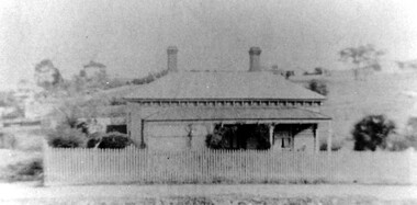
Photograph, 34 Union Road, Surrey Hills - home of the Kleinert family
This was built in 1905 and was the home of William and Emily Kleinert from 1905. William was a coach-builder, wheelwright and blacksmith. He moved from Prahran to Surrey Hills. His son Ernest worked with him as a coach painter and also worked as a painter undertaking intricate hand painting on early cars. Their other son Martin played for the Surrey Hills Football Club. In return for the support given to the club by Mrs Emily Kleinert, the club built a rotunda in South Surrey Park as a memorial to her. Alan Holt research: Lot 6 was sold to Martin Kleinert by Karl Richter in 1860 together with a portion of another adjacent lot. From 1860-1885 Martin worked it as a market garden leasing some land for grazing when it was not required for gardening. He died in 1898. In a formal document, William declared he was the son of Martin "who purchased land in 1860, died in 1898 and the land has been continually occupied by father and family since. It has been cultivated as a market garden; when not being used for gardening it was let for cultivation and grazing." William died in 1939 and the property passed to his sons Martin and Ernest. The Kleinert land extended from Union Road to Essex Road. They ran horses, ducks and fowls and Emily Kleinert grew flowers. The Kleinert property later became the South Surrey Park. The family sold the land to the Camberwell Council in the 1950s. Ernest and Ida Kleinert lived on the corner of Scotsdale and Warrigal Roads. The donor of the photo Nada Harris, nee Kleinert, was Ernest and Ida's daughter. Ida lived to a good age (> 93 years) and in later life lived in Burwood.Black and white photo of a Victorian cottage with a typical bull-nosed veranda. It is set behind a wooden picket fence with undeveloped grazing land studded with mature trees in the background. Taken front-on from the street. There appears to be a path but no formal curb to the road.south surrey park, union road, surrey hills football club, blacksmiths, wheelwrights, coachbuilders, rotunda, miss nada kleinert, mr william kleinert, mrs emily kleinert, mr martin kleinert, mr ernest kleinert, mr karl richter, mrs ida de vasy, mrs nada harris -
 Hume City Civic Collection
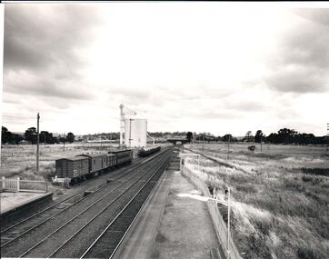
Photograph, 1/01/1971
The photograph was taken when railway land on either side of the tracks was used for recreational purposes and agricultural related activities. The local sports ground is on the RHS of the photograph and was used to stage a number of the town's events.A black and white photograph of a section of the two railway platforms and three sets of rail tracks with a stone bridge in the distance. Four rail carriages and eight goods trucks are on a railway siding near a wheat silo. There is open land on either side of the rail tracks.sunbury railway station, wheat silos, railways, macedon street rail bridge., george evans collection -
 Whitehorse Historical Society Inc.
Legal record - Land Title, Forest Hill
Handwritten list of transfers of land in Forest Hill originally bought by H.R. Kefford in 1867.Handwritten list of transfers of land in Forest Hill originally bought by H.R. Kefford in 1867. Includes land of Nunawading High School and Forest Hill Shopping Centre.Handwritten list of transfers of land in Forest Hill originally bought by H.R. Kefford in 1867. springvale road, forest hill, canterbury road, kefford, h r, wakefield, john, hartnett, rhoda, reed, william, freehold investment and banking company of australia ltd., lane, john owen, mcarthur, henwood, draeger, carl julius otto, arthur herbert, loomes, vincent, biggs, benjamin, broadhurst, harry tootal, foster, henry, hinricks, henry jesse, barnes, john thomas, mary ann, jay, daniel, cuttle, thomas nathaniel, mock, walter edward, glebe street, forest hill chase, nunawading high school, land sales -
 Bendigo Historical Society Inc.
Administrative record - Application Register
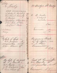
The book is covered in a beige canvas to protect it. It has a leather spine with red and black labels. The pages in the volume are divided in columns: 1) Number of application, 2) Date of registry, 3) Date of application, 4) Surname, 5) Christian name and address, 6) Parish, 7) Allotment, 8) Section, 9) rea, 10) Local land board schedule, 11) Decision, 12) Special condition, 13) License, 14) References and remarks. Only two pages are used dated from 1908 are related to Swan Hill.On the spine red label with gold letters: Application register. A black label with gold letters: all other sections land act 1901. Also, on the spine in black texter 01 to 01 to - B - 145,187application register, land act 1901, 1908 -
 Bendigo Historical Society Inc.
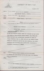
Document - H. A. & S. R. WILKINSON COLLECTION: CONTRACT OF SALE
Contract of sale of land dated 4th April, 1955 between Mrs. M. Phillips (vendor) and Mr. R. J. Pentland (purchaser). Solicitor for vendor and purchaser: Hyett, Willis & Hyett. Property: Land situate in Albert Street, Long Gully described in right to occupy residence area No. 5469 also all vendor’s right. title and interest in land adjoining the above land being land described in permissive occupancy No. W63435, together with weatherboard dwelling and all sundry. Price: 1,600 pounds.organization, business, h.a. & s.r wilkinson real estate -
 Surrey Hills Historical Society Collection
Book, Surrey Hills: in celebration of the centennial 1883-1983, Reprinted November 1992
A pictorial history of Surrey Hills and Mont Albert based on information collected by the history group at the Surrey Hills Neighbourhood Centre. It includes information about early rural properties and dairies, the coming of the railway, land sub-division and early homes, doctors, schools, churches, parks and recreation facilities.A pictorial history of Surrey Hills based on information collected and based at the Surrey Hills Neighbourhood Centre. It includes early rural properties and diaries, the coming of the railway, land sub-division and early homes, schools, parks and recreation.1992surrey hills, railways, land use, migrants, spanish communities, transport, houses, wattle park, festivals and celebrations, churches, education, water supply, fire stations, hospitals, (mr) george klepper, ainger family, (mr) john woodhead, (mr) h. breedon, medical services, real estate agents, businesses, musical events and activities, entertainment, parks and reserves, scouts, guides -
 Bendigo Historical Society Inc.
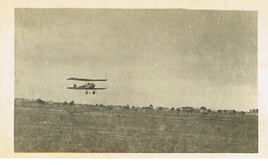
Postcard - BASIL WATSON COLLECTION: BIPLANE FLYING OVER LAND
postcard: biplane flying over land, no location given.aviation, civilian, biplane, basil watson collection, biplane -
 Bendigo Historical Society Inc.
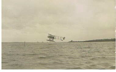
Postcard - BASIL WATSON COLLECTION: BIPLANE ON WATER
postcard: biplane about to land on water, no location givenA. Rapp. Marine Photographer, 39 Bernard Street, Southhamptonaviation, civilian, biplane, basil watson collection, a. rapp -
 Ballarat Heritage Services
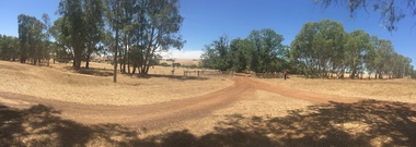
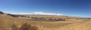
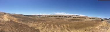
Photograph, Clare Gervasoni, Entrance to Merino Downs Henty, 2015, 22/12/2015
Merino Downs was the property of early squatters the Henty brothers. Pentonvillian Axile George Ind worked for the Henty's at Merino Downs after his arrival at Portland in 1845. The Henty Girls were witnesses to his marriage. Colour photograph of land around Merino Downs, Hentyhenty, merino downs, henty brothers, george ind -
 Ballarat Heritage Services
Photograph, Clare Gervasoni, Entrance to Merino Downs Henty, 2015, 22/12/2015
Merino Downs was the property of early squatters the Henty brothers. Pentonvillian Axile George Ind worked for the Henty's at Merino Downs after his arrival at Portland in 1845. The Henty Girls were witnesses to his marriage. Colour photograph of land around Merino Downs, Hentyhenty, merino downs, henty brothers, george ind -
 Bendigo Historical Society Inc.
Book - GALLAGHER COLLECTION: REAL ESTATE SALES W. MCKEAN & CO, 1930
Book. Land sales. April 1930 to July 1937. -
 Hand Tool Preservation Association of Australia Inc
Pamphlet
This item is part of the Thomas Caine Tool Collection, owned by The National Trust of Australia (Victoria) and curated by the Hand Tools Preservation Association of Australia.4 page promoting ascot vale land sale -
University of Melbourne, Burnley Campus Archives
Document, The University of Melbourne, With Compliments, 1997-2007
stationery, land & food resources, staff -
 Ringwood and District Historical Society
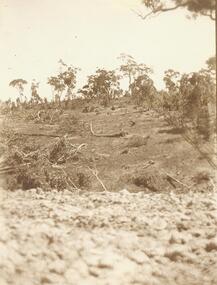
Photograph, Clearing at "Quambee", North Ringwood - 1912
Sepia photograph showing land after partial clearing. -
 Ringwood and District Historical Society
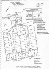
Document - Subdivision Plan, LP17967 Part of Crown Allotment 33, Parish of Warrandyte, County of Evelyn, Vol 6141 Fol 054 - 1948
LANDATA Land Victoria plan printout dated 2008Map includes Wonga Road, Berea Avenue, Fyfe Avenue and Collett Avenue, Ringwood. Markings also include PS309215, LP143952, LP210020, LP24182, LP70960, SP29097, RP9235, SP19956 and LP113437. -
 Ringwood and District Historical Society
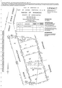
Document - Subdivision Plan, LP40417 Part of Crown Portions 16 & 18, Parish of Ringwood, County of Mornington, Vol 6231 Fol 035 and Vol 8139 Fol 248 - 1957
LANDATA Land Victoria plan printout dated 2008Map includes Heathmont Road, Heathmont, with allotments adjoining Railway Reserve. Other markings include LP95632NS. -
 Ringwood and District Historical Society
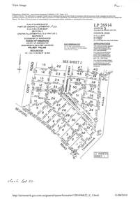
Document - Subdivision Plan, LP26914 Multiple Crown Allotments, Parish of Ringwood, County of Mornington, Vol 8021 Fol 053 - 1954
LANDATA Land Victoria plan printout dated 2010Part of Crown Allotments 1, 1A, 2, 3, 4, 5, 6, 7, 8, 9, 10, 55, 56, 57. Section C Crown Allotments 3, 12 & part of 2. Section B Map includes Bedford Road, Government Road (later Bedford Park Road then Hill Street), Marwarra Street and Tooronga Road, Ringwood. (Sheet 1 of 2 - Sheet 2 not included with collection). -
 Ringwood and District Historical Society
Document - Subdivision Plan, LP10477 Parish of Warrandyte, County of Evelyn, Vol 2453 Fol 574 - 1924
LANDATA Land Victoria plan printout circa 2010Part of Crown Allotment 30. Map includes Warrandyte Road, Kennedy Avenue and Wonga Road, Ringwood. Street name amended from Wonga Road to Loughnan Road 1940. Other markings include CP102182, CP171386, LP127934, PS349846, RP7582, PS309312,RP8679 and CP106336. -
 Ringwood and District Historical Society
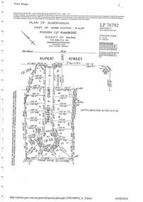
Document - Subdivision Plan, LP76792 Part of Crown Portions 19 & 20A, Parish of Ringwood, County of Bourke, Vol 8382 Fol 140 - 1967
LANDATA Land Victoria plan printout dated 2010Map includes Rupert Street and Prospect Court, Ringwood. -
 Bendigo Historical Society Inc.
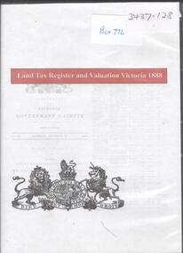
Archive - LAND TAX REGISTER, 1888
DVD. Land Tax Register and Valuation Victoria 1888. -
Clunes Museum
Plan - TITLE PLAN CAMPBELLTOWN, PARISH OF CAMPBELLTOWN, 1876
1 PAGE PHOTCOPY OF LAND TITLE PLANS 18752658 C 364 PARISH OF CAMPBELLTOWN COUNT OF TALBOT COMPILED BY CHARLES MCDONALS 1876campbelltown titles plan, photo-lithographic -
 Ringwood and District Historical Society
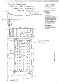
Document - Subdivision Plan, LP23855 Part of Crown Allotment 14B, Parish of Ringwood, County of Mornington, Vol 6687 Fol 394 - 1952
LANDATA Land Victoria plan printout circa 2008Map includes Cuthbert Street, Orchard Grove, and Lowen Avenue (formerly part of Balfour Avenue), Heathmont. Other markings include SP25736, LP98835 and LP40209. Accompanying pencil sketch on light cardboard backing includes sales notations on lots 4 to 8 on Sunset Drive and Cuthbert Street and comment - Roads to be formed & E.L&W provided by vendor. -
 Bendigo Historical Society Inc.
Document - BUSINESS LICENSE PETITION
Handwritten and typed copies of a Business License Petition. Petition is about storekeepers, etc. who have built their businesses on Crown Land. The petitioners hoped that the land upon which they have erected their premises may be surveyed and put up for public auction and that the premises on the land are valued and allowed for.document, names of bendigo pioneers, business license petition, business license petition, i hendry, major general macarthur -
 Kew Historical Society Inc
Photograph - Victorian Double-fronted Brock Villa, Cotham Road, c. 1919
The Kew Historical Society's map collection includes a substantial number of real estate subdivision plans, mainly of Kew but also of surrounding suburbs in Melbourne. Most of the subdivision plans date from the 1920s and 1930s when the districts old homes and local farmland were being split up to accommodate residential growth in the postwar period. These early plans were assembled by a local firm, Jas R Mather & McMillan, which had an office in Cotham Road. Many of the plans, and sometimes photos, were annotated by the agents.Subdivision plans are historically important documents used as evidence for the growth of suburbs in Australia. They frequently provide information about when the land was sold as well as evidence relating to surveyors and real estate and financial agents. The numerous subdivision plans in the Kew Historical Society's collection represent working documents, ranging from the initial sketches made in planning a subdivision to printed plans on which auctioneers or agents listed the prices for which individual lots were sold. In a number of cases, the reverse of a subdivision plan in the collection includes a photograph of a house that was also for sale by the agent. These photographs provide significant heritage information relating house design and decoration, fencing and household gardens.The photograph may also be aesthetically significant depending o the importance of the photographic atelier.Real estate photographs of a classic double-fronted late Victorian brick villa. It central location in Cotham Road, Kew enabled the selling agent to note its proximity to the tram. With seven rooms, all ‘modern conveniences’, and land of 66×167, the house was to be sold for £1100. The villa has a number of interesting features including a pattern within the slate roof as well as the use of polychrome brickwork under the eaves and on the façade. The intricacy of the cast iron lace is emphasised by the line of projecting wooden blocks above it. The picket gate is painted a different colour to the pickets of the fence. The house has a name (illegible) that is attached to the inset cast iron lace of the central projecting gable in the veranda. Stamped on mount: "Kew. Central. Close tram. / Comfortable Brick Villa. / Containing 7 rooms / Modern conveniences: / Land 66 x 167. Sold 1100 pounds:"houses - kew, victorian villas, real estate photographs, cotham road - kew -
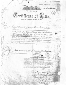 Whitehorse Historical Society Inc.
Document - Land Title, Certificate of Title, 28/10/1902
Certificate of Title for land between Ormond Avenue, Fellows Street, Victoria Avenue and Mitcham Road, Mitcham owned by Robert Becket. Transfers of land through subdivision are included.whitehorse road, mitcham, mitcham road, ormond avenue, victoria avenue, gillies street, deakin street, fellows street, haines street, purches street, albert street, edward street, britannia street, beckett, robert, johnson, catherine, bewley, william, londgerin, mary, chugg, william harold, wheeler, sarah, byrne, bedson, samuel, land subdivision -
Kew Historical Society Inc
Journal - Visitor Book, Fairyland Book
"Fairyland", the home of Jim and Grace Tabulo, was a notable local, state and international tourist attraction situated in Kew, Victoria during the mid twentieth century. Located at 57 Malmsbury Street, Kew, the weatherboard house and its garden were heavily decorated with statues, crockery and other collected items. A series of notebooks were used to record the messages of child and adult visitors to the property from the 1940s to the 1960s. After Mrs Tabulo's death, these visitor books are believed to have formed part of the Dorothy Rogers Collection. They entered the Kew Historical Society's collection following Dorothy Roger's death in 1973.This series of visitor books are the most important primary sources relating to the internationally renowned 'Fairyland' cottage in Malmsbury Street, Kew. Their social significance is that they record in the post war period the values and beliefs of children and adults who visited this historically significant tourist attraction.Foolscap size visitor book containing handwritten comments and drawings primarily made by children during visits to the home of Grace Tabulo, c.1950-1960. Commonly known as "Fairyland", the house was located at 57 Malmsbury Street Kew. The book is wrapped in brown paper, which covers back cardboard covers with a red cloth strip binding. Unpaginated, approximately 160 pages, and covers. The book has an additional loosely inserted black card cover located at the front of the book.Handwritten in pencil on paper cover: "1950 - 1962 /(edit book dates)" Handwritten in ink on paper label on loosely inserted cover: "Fairy Land / Book/ September 1950 / Fairy Land / Book / 75 [sic] M...berry [indistinct] st Kew / Fairy Land Book"grace tabulo -- fairyland -- 57 malmsbury street -- kew (vic.), tourism - kew - 1945-1965, childhood - kew, collectors and collecting, gardens - kew (vic), scrapbooks - 20th century -
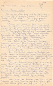
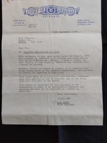 Mont De Lancey
Document - Shire of Lillydale: Planning Application, Shire of Lillydale, 12th September, 1974
Vintage legal documents for land division in Victoria, especially those predating the Torrens system (October 1862), are often found in the Public Record Office Victoria (PROV). These documents, like deeds and Crown grants, can help trace the history of land ownership and division. A letter from K.H. Scott, Shire Engineer of the Shire of Lillydale Victoria to M. H. Proctor Re: Planning Application P.S./833. It is typed on the blue elaborately printed Shire letterhead and dated 12th September, 1974. The application from Mr Proctor to subdivide land situated and described as C.C. 12 Sec B Queens Road., Wandin was granted. Conditions apply.Signed 'Yours faithfully K H Scott K.H. Scott Shire Engineer' 'In reply please quote 1832:74 MGE:DW'legal documents, contracts, documents, indentures