Showing 2185 items
matching nillumbik
-
 Eltham District Historical Society Inc
Photograph, Liz Pidgeon, Heritage Excursion; East of Eltham, 6 Sep 2014, 20 May 2017
Newsletter No. 218, September 2014 September Excursion - East of Eltham Walk In Newsletter No. 197, March 2011, there was a brief history of Crown Allotment 15 Section 5 Parish of Nillumbik (CA 15) a parcel of land of a quarter of a square mile extending from Eucalyptus Road to Reynolds Road at the eastern extremity of Eltham. From the 1940s it was known as Stokes orchard. In later years it has been subdivided for residential purposes but leaving significant areas as power line and water supply reserves and bushland reserves that are habitat for the threatened For our excursion on 6th September we intend to walk through CA 15 to a bushland reserve east of Reynolds Road. The walk will traverse the boundary between suburban Eltham and the non-urban areas to the south and east. This is a pleasant walk through residential areas and bushland. Along the way we will discuss the early and more recent history of CA 15 as well as local natural history and geology. This walk is about 3.5 km in length and will take 2 to 2.5 hours. It will start at 2pm at the corner of Eucalyptus Road, Pitt Street and Nyora Road.Born Digitaleltham east, eltham district historical society, heritage excursion, activities, nyora road, reynolds road, gum tree road reserve, diosma road, stokes orchard, eucalyptus road -
 Eltham District Historical Society Inc
Photograph - Digital Photograph, Marguerite Marshall, Former home of Professor William MacMahon Ball, York Street, Eltham, 24 May 2007
Situated at the eastern end of York Street, Eltham, 'Shinrone', the former home of Professor William (Mac) MacMahon Ball was one of the first in the Shire of Eltham to incorporate mud-brick. Professor MacMahon Ball, a political scientist, writer, broadcaster and diplomat and family moved to York Street, Eltham in 1945 into a timber cottage built around the 1890s and in poor repair. Mac asked Alistair Knox to renovate the home and he expanded the living area and added verandahs. In 1948 Montsalvat artist and sculptor Sonia Skipper supervised the building of most of the mud-brick studio. Neighbour Gordon Ford made the mud-bricks. Mac also asked John Harcourt, who had worked with him as a journalist in shortwave broadcasting, to build a pise (rammed earth) and stone addition to the largely timber house. Harcourt built two bedrooms - including an attic bedroom - a balcony with a shower and toilet, a nd a fireplace and chimney of local stone. Published: Nillumbik Now and Then / Marguerite Marshall 2008; photographs Alan King with Marguerite Marshall.; p141This collection of almost 130 photos about places and people within the Shire of Nillumbik, an urban and rural municipality in Melbourne's north, contributes to an understanding of the history of the Shire. Published in 2008 immediately prior to the Black Saturday bushfires of February 7, 2009, it documents sites that were impacted, and in some cases destroyed by the fires. It includes photographs taken especially for the publication, creating a unique time capsule representing the Shire in the early 21st century. It remains the most recent comprehenesive publication devoted to the Shire's history connecting local residents to the past. nillumbik now and then (marshall-king) collection, eltham, alistair knox, gordon ford, john harcourt, mudbrick construction, pise construction, professor macmahon ball, shinrone, sonia skipper, york street -
 Eltham District Historical Society Inc
Slide - Photograph, On the Eltham Road, Walter Withers (1906), Heidelberg School Artists Trail, Alistair Knox Park, Eltham, c.Nov. 2001
The Heidelberg School Artists Trail was established in about 1999 with about 52 signs across four local governemnt areas including Nillumbik and Banyule. It extends from Heidelberg through Eltham and Warrandyte and to the Dandenongs. It features signs depicting paintings of artists in the location in which they were painted. This one acknowledges "On the Eltham Road", 1906. Transcription of the text states: "In this cheerful rural landscape, Walter Withers has captured the spirit of early Eltham. Eltham was a quiet, sleepy village, where geese wandered up the main Road and the locals either walked or rode their horses or bicycles around the township. Walter Withers was known to load up his bicycle with his collapsible easel, folding stool, paint box, water bottle and canvases, and would head off for a day’s painting. He was also known for his walking, as was his family, and they became known as the ‘Walking Withers’ Part of a slide show presentation "A Trip Down the Diamond Creek" by Russell Yeoman to the Eltham District Historical Society meeting of 14 Nov. 200135mm colour positive transparency Mount - Black and Whiteeltham, alistair knox park, heidelberg school artists trail, on the eltham road, public art, sign, walter withers -
 Eltham District Historical Society Inc
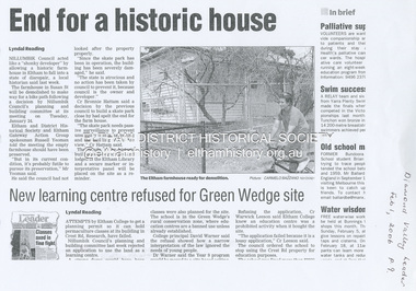
Document - Property Binder, 66 Susan Street, Eltham
Newspaper clipping (photocopy/digital only): End for a historic house, Lyndal Reading, Diamond Valley Leader, February 1, 2006, p9Alistair Knox Park, Eltham, Eltham Skate Park A small cream cottage with green roof. The farmhouse built in the late 1800s by the Crozier Family. Subsequently owned by the Hill Family. Purchased in the early 1960s and by 1965 the property was owned by the Shire of Eltham. Employees of the Shire lived in the house. Susan Street originally ran all the way north of Bridge Street to the bend where it turned to the left into Brisbane Street. Today that section of Susan Street has been renamed as an extension of Brisbane Street. In 2006 the Shire of Nillumbik demolished the house which had been subject to extensive vandalism. In accordance with heritage advice and a permit condition a sign was placed on the site outlining the history of the building. This was installed and remained in place till about 2016 when it was removed. The land adjoins Alistair Knox Park. By 2010 the Eltham Skate Park was developed. In 2022 a major renovation and extension took place. Sources: EDHS Newsletter No 171 November 2006alistair knox park, eltham, eltham skate park, house, susan street