Showing 22277 items
matching parks
-
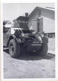 8th/13th Victorian Mounted Rifles Regimental Collection
Photograph
8/13 VMR was equipped with Ferret Scout in 1959. The 8th/13th Victorian Mounted Rifles was raised as a regiment of the Royal Australian Armoured Corps on 1 May 1948 with Headquarters in Melbourne and squadrons in Sale, Benalla/Wangaratta and Albury. In 1955 Regimental Headquarters moved to Wangaratta and a second squadron was located at Albury. The Sale squadron transferred to 4th/19th Prince of Wales’s Light Horse. In 1977 8/13 VMR Regiment was reduced to an independent squadron A Squadron 8th/13th Victorian Mounted Rifles and in 1991 was linked with 4th/19th Prince of Wales’s Light Horse forming the VMR Squadron of that regiment.Collection of photographs showing early evolution of an armoured regiment of the Citizen Forces as it progressed from WWII equipment and uniforms to post-war equipment and uniforms. Silver regimental hat badges are worn in place of Rising Sun badge.Black and White photograph of Ferret Mk11 Scout Car parked in front of a building at Puckapunyal -
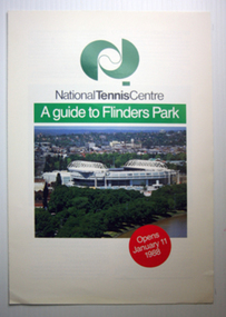
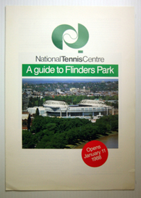 Tennis Australia
Booklet
National Tennis Centre: A Guide to Flinders Park. 4 pages Materials: Paper, Inktennis -
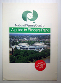
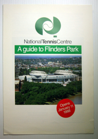 Tennis Australia
Booklet
National Tennis Centre: A Guide to Flinders Park. 4 pages Materials: Paper, Inktennis -
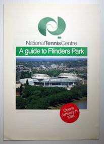
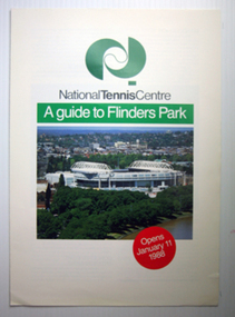 Tennis Australia
Booklet
National Tennis Centre: A Guide to Flinders Park. 4 pages Materials: Paper, Inktennis -
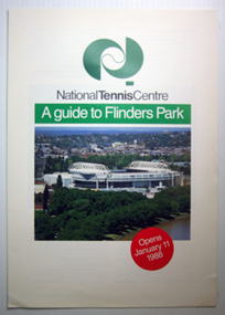
 Tennis Australia
Booklet
National Tennis Centre: A Guide to Flinders Park. 4 pages Materials: Paper, Inktennis -
 Tennis Australia
Booklet
National Tennis Centre: A Guide to Flinders Park. 4 pages Materials: Paper, Inktennis -
 Tennis Australia
Booklet
National Tennis Centre: A Guide to Flinders Park. 4 pages Materials: Paper, Inktennis -
 Tennis Australia
Booklet
National Tennis Centre: A Guide to Flinders Park. 4 pages Materials: Paper, Inktennis -
 Tennis Australia
Booklet
National Tennis Centre: A Guide to Flinders Park. 4 pages Materials: Paper, Inktennis -
 Southern Sherbrooke Historical Society Inc.
Minutes of the Lysterfield Lake Park Advisory Committee, 1980-1988, 1980-1988
Minutes created by Advisory Committee then donated to the society by Denise Tutt who was a community representative on the committee.An A3 folder containing minutes and supplementary documents for the Lysterfield Lake Park Advisory Committeelysterfield lake park, shire of sherbrooke, recreational facilities -
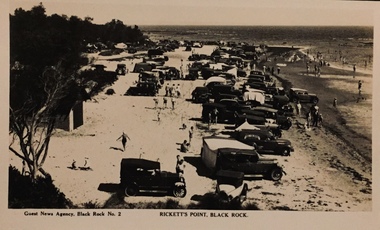 Kew Historical Society Inc
Postcard, Guest Newsagency, Rickett's Point, Black Rock
One of a number of 'real photo' and commercial postcards created by or owned by members of the Christian and Washfold families of Kew. The postcards are part of a larger collection of photographs, postcards and publications donated to the collection in May 2021.Sepia postcard of the beach at Black Rock showing swimmers and cars parked along the beachGuest Newsagency, Black Rock No.2rickett's point, postcards -- beaches, christian-washfold collection -
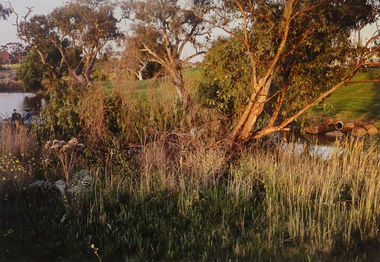 Brimbank City Council Art Collection
Photograph, Kororoit Creek, Opposite Deer Park Hotel, 1994
Local LandscapeOpposite Deer Park Hotel, West Side Kororoit Creek looking East AR0108photograph, landscape -
 Brimbank City Council Art Collection
Photograph, Robert Pointon, Footpaths each side of Kororoit Creek, 1989
Local SceneLocal SceneFootpaths each side of Kororoit Creek facing north in Deer Park - AR 0016 -
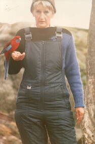 Sunbury Family History and Heritage Society Inc.
Photograph, School Camp, 1988
The ranger was helping the students from Bulla and MIckleham Primary Schools how to encourage the birds, that they were studying, how to perch on their arms.The children were attending a school camp at Beechworth and one of their activities was to become acquainted with the native birds in the area.A non-digital coloured photograph of a park ranger with a crimson rosella perched on her arm.school camps, beechworth, crimson rosellas, bulla primary school, mickleham primary school -
Federation University Historical Collection
Book - Minute Book, Eureka Stockade Memorial Park Committee Minute Book, 1988 - 1996
Red minute book containing the handwritten minutes of the Eureka Stockade Memorial Park Committee.john, eureka stockade, williams, lake penhalluriack, eureka swimming pool, a barnett, eureka caravan park, g mckenzie, s mckenzie, j jones, w ham, g drake, j douglas, r chittock, g taite, s elshaug, j murray, j berriman, berriman, j webb, f kennan, s romeo, paul, bob o brien, glen drake, graeme mckenzie, rigby cooke, steve romeo, jeff webb, stan mckenzie, gordon taite, wally ham, geoff webb, andrew mckay, ron chottock -
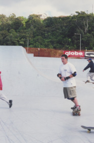 Lakes Entrance Regional Historical Society (operating as Lakes Entrance History Centre & Museum)
Photograph, Lakes Post Newspaper, 2000
number in album 03587.03Colour photograph Skateboard Park opening, skater Jason Thomas. Lakes Entrance Victoriasports, celebrations -
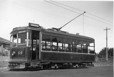 Ballarat Tramway Museum
Photograph - Black & White Photograph/s, Leon Marshall Wood, Mar. 1947
Black and white photograph of Geelong No. 14, Birney, with apparent destination of Eastern Park. Photographer - Leon Marshall-Wood, March 1947. Dave O'Neil confirmed June 30/2009, photo at the Western Park terminus. Up to 1951, Eastern Park was only operated by City to Eastern Park services, after 1951 through routed to Newtown. No. 14 was in Bendigo by then. See related documents. .1 - Copy small format print from Lloyd Rogers collection via Robert Green 2/2014. Added 4-4-2019On rear in pencil "3?, S/S, L M-W" and in light green pencil, "PWD" and "Owned JR". On rear of copy print 4194.1 - "Geelong" in top left hand corner.tramways, trams, geelong, eastern park, birney, tram 14 -
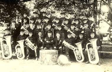 Federation University Historical Collection
Photograph - black and white, City of Ballarat Band, 1923?
Frank Wright was a renown resident of Smeaton, where he was born on 2 August 1901. He lived at Laura Villa, and attended Smeaton State School. His father William was a gold miner and his mother's name was Sarah. Their family won many singing and instrumental awards. Frank was tutored by Percy Code and was awarded a gold medal for the highest marks in the ALCM examinations in the British Colonies at the age of seventeen years. He became the Australian Open Cornet Champion by the age of eighteen. A year later, Frank conducted the City of Ballarat Band, and later the Ballarat Soldiers’ Memorial Band. He formed the Frank Wright Frisco Band and Frank Wright and his Coliseum Orchestra. These bands won many South Street awards, and Frank as conductor won many awards in the Australian Band Championship contest. In 1933 Frank Wright sailed to England to conduct the famous St Hilda’s Band and was later appointed Musical Director of the London County Council, where he organized many amazing concerts in parks, in and around the London district. He was made Professor of Brass and Military Band Scoring and conducted at the Guildhall of Music and Drama. Frank was often invited to adjudicate Brass Band Championships around Europe, in Australia, including South Street and in New Zealand. The Frank Wright Medal at the Royal South Street competition is awarded to an individual recognized as making an outstanding contribution to brass music in Australia.Black and white photograph of the members of a brass band with their instruments and some gentlemen in suits. They are situated in a park with trees as the backdrop. In the lower centre front position is Frank Wright. The band is the City of Ballarat Band.frank wright, conductor, brass band, city of ballarat band -
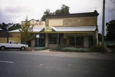 Charlton Golden Grains Museum Inc
Photograph, Charlton High Street 1988
Charlton High Street centre 1988. Vic Arundell's Shoe Shop, Stock & Station Agent and former W. Williams Saddlery (later Bullock's Grocery). Buildings latr demolished to become the Traveller's Rest. Williams St renamed John Curtin Drive.Colour photograph of Vic Arundell's shop and former W. Williams Saddlery on the corner of High St and Williams St. For Sale sign over the middle building. White ute parked in front of Arundell's. Another ute parked at side of buildings.high st, vic arundell's shoes, w.williams saddlery, bullocks grocery -
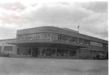 Bendigo Historical Society Inc.
Photograph - S.E.C. VICTORIA, 1954
Black and White Photo of the S.E.C. Victoria Building, Decorated for the Royal Visit in March 1954, Opening of the S.E.C. Building in 1941. Car parked to left in photo, and another angle parked to right of photo. Flag on roof flying a half mast.organization, public utility, electricity company, s.e.c. victoria, sec victoria -
Whitehorse Historical Society Inc.
Document, Minutes of Meeting re Schwerkolt Cottage, 22/03/1994
Minutes of meeting in relation to car parking and the formation of a 'Friends' group at Schwerkolt Cottage, with representatives of Nunawading Historical Society, cottage attendant, wedding celebrant, Mitcham Arts Association, Manager Parks & Recreation and Parks Officer - Area North East.schwerkolt cottage, mitcham arts association, city of nnawading -
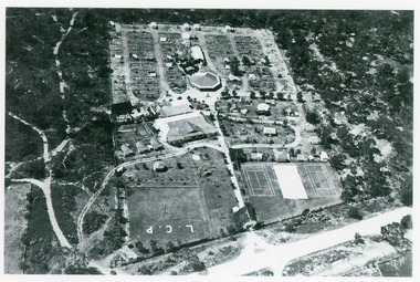 Lakes Entrance Regional Historical Society (operating as Lakes Entrance History Centre & Museum)
Photograph, Bulmer H D, 1935
Black and white aerial view of Whiters Camp Park, looking north from Roadknight Street, showing layout of park including tennis courts, bowling green, picnic area, cottages, rotunda, and the family residence. Lakes Entrance Victoriaguesthouses, tourism, people -
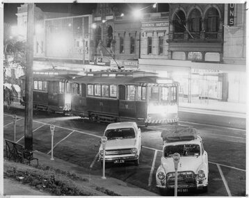 Ballarat Tramway Museum
Photograph - Black & White Photograph/s, John Phillips, early 1970s
Night photograph of single truckers 26 (front) and 28 parked in City Loop, with lights on. Taken early 1970's. Two cars parked kerb, Holden and a Morris Minor, with parking meters. In rear is the buildings of Edments Hartleys, and Patersons.trams, tramways, ballarat, sturt st., city loop , tram 26, 28 -
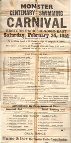 Bendigo Historical Society Inc.
Document - BERT GRAHAM COLLECTION: MONSTER CENTENARY SWIMMING CARNIVAL, 24 Feb 1951
Events, Bert Graham Collection, Monster Centenary Swimming Carnival, Eastern Park, Bendigo East, Saturday February 24, 1951, in aid of Improvements to Eastern Park, to be opened by His Worship the Mayor of Bendigo (Cr. N.J.Oliver) at 3 o'clock.bendigo, clubs, bendigo east swimming carnival -
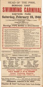 Bendigo Historical Society Inc.
Document - BERT GRAHAM COLLECTION: HEAD OF THE POOL BENDIGO EAST, 23 Feb 1946
Events, Bert Graham Collection, Head of the Pool Bendigo East Swimming Carnival, Eastern Park, Saturday February 23, 1946, in aid of the improvements to Eastern Park. To be Officially opened by His Worship the Mayor of Bendigo (Cr.A.Truscott) at 3 o'clock.bendigo, clubs, bendigo east swimming carnival -
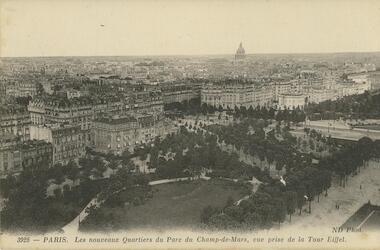 Bendigo Historical Society Inc.
Postcard - ROY AND DORIS KELLY COLLECTION: PARIS, LES NOUVEAUX QUARTIERS DU PARC DU CHAMP-DE-MARS, VUE PRISE DE LA TOUR EIFFEL,CARTE POSTALE, 1900-1920
Postcard, B&W photograph, taken from the Eiffel Tower in Paris, of the new section of the Champs-de-Mars park. The park and trees have been tinted green for the postcard. Among the buildings in the distance can be seen the dome of the Pantheon.postcard, photograph, postcard, paris, parc du champ-de-mars, eiffel tower, pantheon -
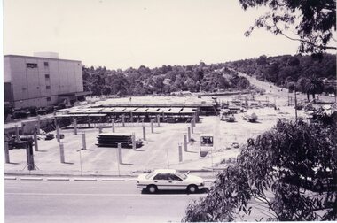
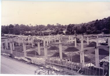 Ringwood and District Historical Society
Photograph, Eastland car park construction -1992
Sepia postcard size photograph"Written on back of photograph" Eastland - Stage 2 Foundations for new car park -24.11.92 -
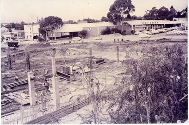
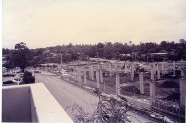 Ringwood and District Historical Society
Photograph, Eastland car park construction -1992
Sepia postcard size photograph"Written on back of photograph" Eastland - Stage 2 Foundations for new car park -24.11.92 -
 Ringwood and District Historical Society
Photograph, Eastland car park construction -1992
Sepia postcard size photograph"Written on back of photograph" Eastland - Stage 2 Foundations for new car park -24.11.92 -
 Ringwood and District Historical Society
Photograph, Eastland car park construction -1992
Sepia postcard size photograph"Written on back of photograph" Eastland - Stage 2 Foundations for new car park -24.11.92