Showing 1944 items
matching victoria bridge
-
 Lakes Entrance Regional Historical Society (operating as Lakes Entrance History Centre & Museum)
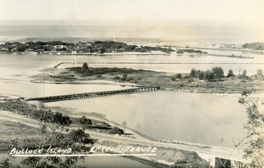
Postcard, Bulmer H D, 1945
Black and white postcard of Bullock Island, Lakes Entrance, showing an extensive rock groyne to the south of the island, into which dredged sand and spoil is to be placed in order to extend the island's area. North Arm bridge, Bullock Island footbridge, New Works settlement and Entrance channel also in image. Lakes Entrance VictoriaBullock Island, Lakes Entranceboats and boating, fishing industry, islands -
 Lakes Entrance Regional Historical Society (operating as Lakes Entrance History Centre & Museum)
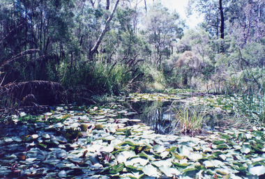
Photograph, 1999
Water lilies reputedly planted by Mrs Horsfield of Lakes Entrance Garden Club.Colour photograph of the lily pond near the railway trestle bridge at Stoney Creek, shows a pond covered with lily leaves and flower buds, surrounded by scrubby bushland. Nowa Nowa Victoriavegetation -
 Lakes Entrance Regional Historical Society (operating as Lakes Entrance History Centre & Museum)
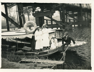
Photograph, 1923 c
Black and white photograph showing two tourist ferries, MV Rubeena and possibly MV Loch Ard, tied up below the old Swan Reach bridge on the Tambo River. Shows three ladies on the Rubeena, and one man on the Loch Ard. The Union Jack flag flying on the Loch Ard. Swan Reach Victoriawaterways, boats and boating, tourism -
 Lakes Entrance Regional Historical Society (operating as Lakes Entrance History Centre & Museum)
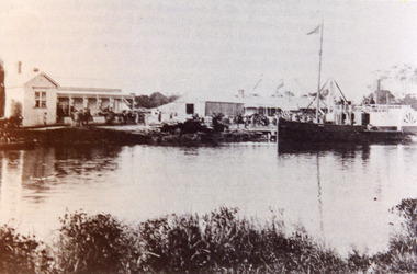
Photograph, Cornell F, 1880 c
Also new sepia print 10 x 15 cm. See also Peter Synan's book 'Highways of Water'Sepia photograph showing paddle steamer Tanjil at Latrobe Wharf. Swan Hotel on left and Victoria Hotel on right. Timber stacked on wharf. People on wharf and in small boats on river on left, taken from opposite side of Latrobe River. This scene is immediately downstream of present swing bridge on Latrobe River. Sale Victoriaboats and boating, jetties, houses, disasters -
 Lakes Entrance Regional Historical Society (operating as Lakes Entrance History Centre & Museum)
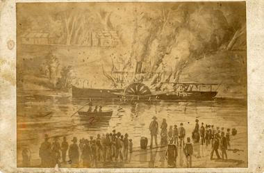
Postcard, 1885 c
Photo mounted on card. This Tanjil was the first one. Original archived in a safe place because of its fragile condition.Sepia photograph showing painting depicting view of P S Tanjil on fire at Bairnsdale Wharf. People on wharf watching fire, rowing boat on fire, Tanjil at opposite bank, huts above. Bairnsdale Victoriaships and shipping, jetties, retail trade, fences, bridges -
 Lakes Entrance Regional Historical Society (operating as Lakes Entrance History Centre & Museum)
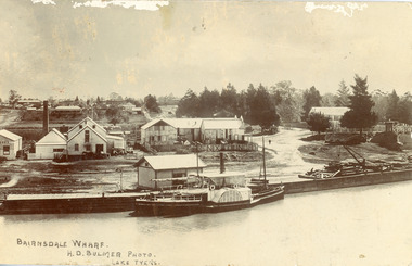
Postcard, Bulmer H D, 1910 c
Postcard was addressed to Mr. H Lindamen, C/o JCD, Bairnsdale. Postcard bears a One Penny red Queen Victoria stamp, franked with number 17. Message on card scribbled out, another stamp has been removed. Also enlargement 16 x 25 cmBlack and white postcard showing P S Tanjil at Bairnsdale Wharf, Victoria. Shed and timber and hand crane on wharf. Industrial buildings, eg, butter factory, foundry behind wharf, post and rail fences, gravel roads and tannery on right, pine trees and end of bridge on far right. Bairnsdale township in background.Bairnsdale Wharf. H.D Bulmer Photo Lake Tyersships and shipping, waterways, bridges -
 Lakes Entrance Regional Historical Society (operating as Lakes Entrance History Centre & Museum)
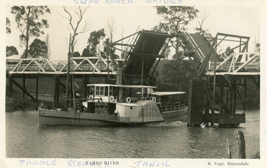
Postcard, Vogt, Stanley, 1920 c
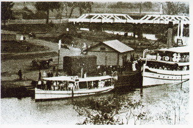
Two copies existBlack and white postcard showing P S Tanjil passing downstream under Swan Reach Bridge on Tambo River, East Gippsland, Victoria.Paddle Steamer Tanjil Tambo River Swan Reach Bridge. S. Vogt Bairnsdaleships and shipping, waterways, bridges -
 Lakes Entrance Regional Historical Society (operating as Lakes Entrance History Centre & Museum)
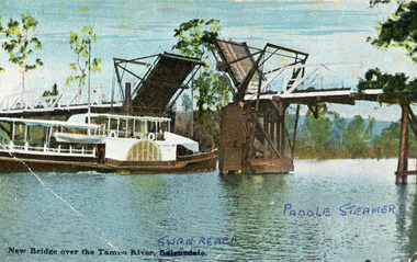
Photograph, V S M Series, 1920 c
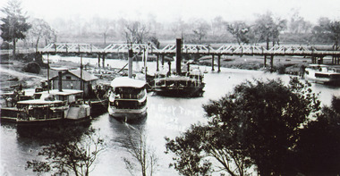
Hand tinted postcard showing Paddle Steamer 'Tanjil' passing upstream under the open Swan Reach Bridge on the Tambo River, East Gippsland, Victoria.New Bridge over the Tambo River Swan Reach Paddle Steamerships and shipping, waterways, jetties -
 Lakes Entrance Regional Historical Society (operating as Lakes Entrance History Centre & Museum)
Photograph, 1908
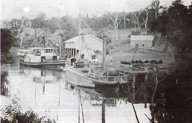
Black and white photograph showing P S Tanjil left and S S Burrabogie right at Mossiface Wharf on the Tambo river. Larger open sided white shed at wharf, smaller shed further back, pipes on wharf small row boat beside stern of Burrabogie. Hillside partly cleared trees ring barked. East Gippsland Victoriaships and shipping, bridges, waterways -
 Lakes Entrance Regional Historical Society (operating as Lakes Entrance History Centre & Museum)
Photograph, 1911
Black and white photograph showing P S Tanjil, S S Gippsland and dredge Pioneer at Bairnsdale wharf, steamer J C D at opposite bank. Early road bridge across Mitchell River. Bairnsdale Victoriaships and shipping, waterways, vegetation -
 Lakes Entrance Regional Historical Society (operating as Lakes Entrance History Centre & Museum)
Postcard, 1930 c
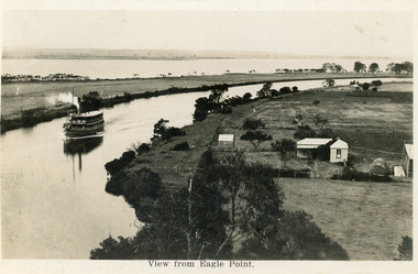
Black and white postcard S S Gippsland in Mitchell River, travelling towards Bairnsdale, silt jetties extending eastwards small farm, farm house and sheds on right. Jones bay in Middle distance beyond silt jetty, taken from Eagle Point Bluff. Bairnsdale VictoriaView from Eagle Point.jetties, transport, ships and shipping, bridges -
 Lakes Entrance Regional Historical Society (operating as Lakes Entrance History Centre & Museum)
Photograph, 1912 c
Black and white photograph showing steamer Lady Harriet on left, S S Gippsland on right at Bairnsdale wharf on Mitchell River, railway track behind Lady Harriet, horse and jinker at wharf, shed at wharf, road bridge over river with people in background. Bairnsdale Victoriaarts, associations -
 Lakes Entrance Regional Historical Society (operating as Lakes Entrance History Centre & Museum)
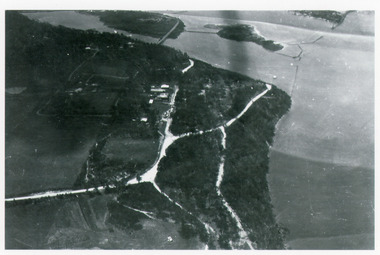
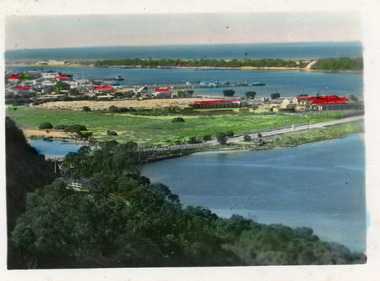
Photograph, Bulmer H D, 1940c
Black and white photograph of aerial view of Kalimna escarpment, Princes Highway, road to Kalimna Hotel, scattering of buildings including Gainsborough House, in distance is North Arm bridge, footbridge to undeveloped Bullock Island with rock groynes in place. Part of eastern pier of entrance at Lakes Entrance, Victoria.jetties, waterways, topography, township -
 Lakes Entrance Regional Historical Society (operating as Lakes Entrance History Centre & Museum)
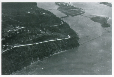
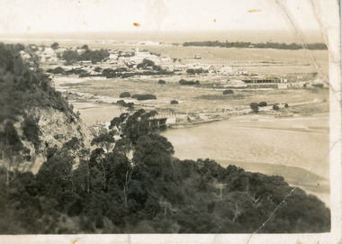
Photograph, Bulmer H D, 1940c
Black and white photograph of aerial view of Kalimna Heights, showing scattered buildings, Princes Highway around side of cliff, western end of township, North Arm bridge, footbridge to Bullock Island, and rock groynes. Track to lookout and signal beacon visible. Lakes Entrance Victoriaboats and boating, jetties, waterways, vegetation -
 Lakes Entrance Regional Historical Society (operating as Lakes Entrance History Centre & Museum)
Postcard, Bulmer H D, 1922c
Black and white photographic postcard, showing early aerial view of township of Lakes Entrance, Cunninghame Arm, North Arm and sand dunes, ocean in lower foreground, Eastern wharf and various boats on lake. Princes Highway went along Esplanade, Myer Street and Roadknight Street, very little vegetation on sand dunes, no foot bridge yet, good view of North Arm, few houses. Lakes Entrance VictoriaLakes Entrance and Backwater from the Air.islands, aerial photograph, waterways, topography, township -
 Lakes Entrance Regional Historical Society (operating as Lakes Entrance History Centre & Museum)
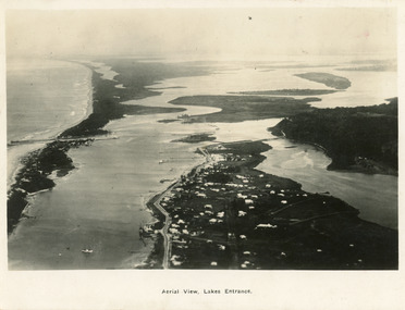
Postcard, 1923c
Also large postcard 15 x 20|Also two mini postcard 6 x 9|Also copy black and white 9 x 14.5Black and white postcard of an aerial view of township of Lakes Entrance, showing western end of town, jetties and boat harbours in Cunninghame Arm, the entrance and piers, North Arm bridge, Bullock Island, Rigby, Fraser and Flannegan Islands, and a distant view of Boole Poole, Bunga Arm and Lake King. Lakes Entrance VictoriaAn aerial view showing position of Lakes Entranceaerial photograph, islands, waterways, topography -
 Lakes Entrance Regional Historical Society (operating as Lakes Entrance History Centre & Museum)
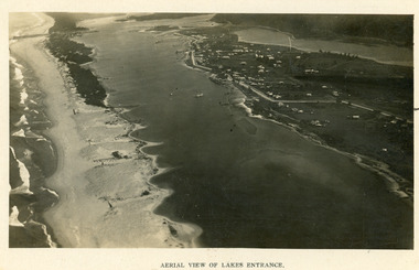
Photograph, 1923c
Two copies 16.5 x 25.5 very darkBlack and white photograph showing early aerial view of township of Lakes Entrance, photo shows highway going along Myer Street and along Roadknight Street, no shops in Myer Street appears to be no foot bridge, therefore taken prior to 1937, sparce vegetation on foreground dunes, four barriers built on dunes to stop erosion through sand, two masted sailing boat in lake. Bullock Island in distance appears very small, Snake Island of Rigby Island in centre distance. Lakes Entrance VictoriaAerial View of Lakes Entrancewaterways, coast, aerial photograph, islands -
 Lakes Entrance Regional Historical Society (operating as Lakes Entrance History Centre & Museum)
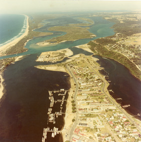
Photograph, 1980c
Colour photograph aerial view of township of Lakes Entrance, showing western end of town, Bullock Island, Cunninghame Arm and North Arm, man made entrance, and distant view of outer barrier, island and shoreline. Lakes Entrance Victoriawaterways, township, restaurant, bridges -
 Lakes Entrance Regional Historical Society (operating as Lakes Entrance History Centre & Museum)
Photograph, 1985c
Photo was cut from Tourist brochureColour photograph showing aerial view of township and the Ninety Mile Beach. Pecks factory on Bullock Island, Old North Arm bridge, bitumen for carpark for future. Fishermen's Club near North Arm Bridge. Photo shows East end of Rigby Island and Snake Island. Glimpse of Red Bluff, Lake Bunga and Lake Tyers in far east. Lakes Entrance Victoriabridges, coast, waterways, topography -
 Lakes Entrance Regional Historical Society (operating as Lakes Entrance History Centre & Museum)
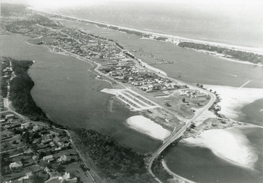
Photograph, 1975c
Black and white photograph of an aerial view of township and Kalimna Heights, showing the North Arm bridge and boat ramp, sand buildup in the lake system, boat harbour, sand hummocks and beach as far as Red Bluff. Lakes Entrance Victoriaaerial photograph, islands, topography -
 Lakes Entrance Regional Historical Society (operating as Lakes Entrance History Centre & Museum)
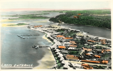
Photograph, 1945c
Two tinted copies, one 8.5 x 13.5 and one 6.5 x 9Black and white postcard showing town, twelve memorial cypress trees and spotting tower on foreshore, post office wharf, boat harbour, Club Hotel at west end of esplanade with five palm trees opposite, causeway to Bullock Island, highway bridge over North Arm, highway up to Jemmys Point, Rigby, Fraser and Flannagan Island's towards Metung. Lakes Entrance VictoriaLakes Entrancecoast, islands, aerial photograph, waterways -
 Lakes Entrance Regional Historical Society (operating as Lakes Entrance History Centre & Museum)
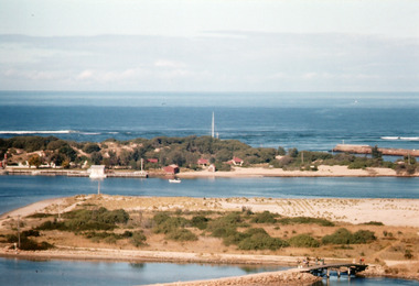
Photograph, 2000
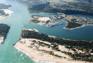
Colour photograph aerial view of the entrance, shows entry to North Arm, Cunninghame Arm, Bullock Island, part of Rigby Island, new North Arm Bridge in place, Club Hotel still in situ, small dredge working south west corner of Bullock Island. Lakes Entrance Victoriaislands, dredging, waterways -
 Lakes Entrance Regional Historical Society (operating as Lakes Entrance History Centre & Museum)
Photograph, 1980
Also two different views of Lakes Entrance from KalimnaColour photograph showing the township situated on the land between the two stretches of water,the North Arm and the Cunninghame. In the background can be seen the sand hummocks and the Southern Ocean. Lakes Entrance Victoriaconstruction, township, waterways, bridges -
 Lakes Entrance Regional Historical Society (operating as Lakes Entrance History Centre & Museum)
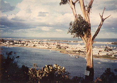
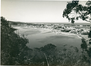
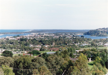
Photograph, 1955
Also black and white postcard, similar view, titled Lakes Entrance through the trees from Lovers Walk. Bulmer copyright.Black and white photograph of a view from Kalimna Heights overlooking township. Shows North Arm, Marine Parade, Cunninghame Arm and sand hummocks with Bass Strait in distance. Lakes Entrance Victoriafishing industry, public works, bridges -
 Lakes Entrance Regional Historical Society (operating as Lakes Entrance History Centre & Museum)
Postcard, 1930c
Black and white small format postcard showing the township situated on the land between the Cunninghame Arm and North Arm. Lakes Entrance VictoriaLakes Entrance from Princes Highway (on back)bridges, township, topography, waterways -
 Lakes Entrance Regional Historical Society (operating as Lakes Entrance History Centre & Museum)
Postcard, 1998c
Tinted small format postcard showing the township situated on the isthmus between two stretches of water the Cunninghame Arm and the North Arm. Work in progress widening the North Arm Bridge as seen by workmen's huts beside the southern approach. Lakes Entrance Victoriajetties, waterways, topography, township -
 Lakes Entrance Regional Historical Society (operating as Lakes Entrance History Centre & Museum)
Photograph, 1962
... to island via humpy bridge. Lakes Entrance Victoria... access to island via humpy bridge. Lakes Entrance Victoria ...Image printed from 35mm slideColour photograph of Bullock Island showing cleared and grass planted south eastern area in preparation for relocation of Public Works and fishing industry facilities. Traffic access to island via humpy bridge. Lakes Entrance Victoriabridges, waterways, topography, township -
 Lakes Entrance Regional Historical Society (operating as Lakes Entrance History Centre & Museum)
Photograph, Tambo Shire, 1990c
Also second copy photographic enlargements of significant sites in the Tambo ShireColor photograph of the township, showing a distant view of the Ninety Mile Beach, the Gippsland Lakes and islands, Kalimna Heights, the bridge over the North Arm, Cunninghame Arm, and a broad view of the town and tree lined streets. Lakes Entrance Victoriabridges, topography, township, waterways -
 Lakes Entrance Regional Historical Society (operating as Lakes Entrance History Centre & Museum)
Photograph, Fish Marie, 1985c
Colour photograph of township, showing building on Bullock Island, Cunningham Arm and small white shed on old New Works Jetty near the entrance, view towards the barrier. Photo taken from near telecom tower on Merrangbaur Hill 1985c. Lakes Entrance Victoriatopography, township, waterways, bridges -
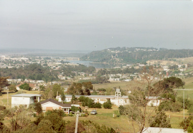 Lakes Entrance Regional Historical Society (operating as Lakes Entrance History Centre & Museum)
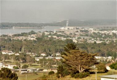
Photograph, Fish, Marie, 1985c
Colour photograph of township, showing buildings, Jemmys Point, Mount Barkly, Kalimna Heights, North Arm and old North Arm bridge, and Rigby Island beyond. Sea Vista flats in foreground. Photo taken from near Telecom Tower on Merrangbaur Hill. Lakes Entrance Victoriatopography, township, waterways, bridges