Showing 11524 items matching "maps"
-
 Wangaratta RSL Sub Branch
Button
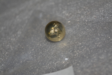
Small gold coloured Australian Military Forces button.On front: Map of Australia with a crown on top. On back: Stokes Melbaustralian military forces, button -
 Bacchus Marsh & District Historical Society
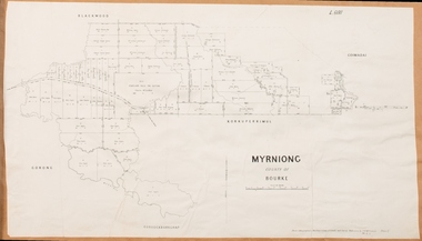
Map, Myrniong Parish Map 1904
A single page paper map showing the map for the Parish of Myrniong in the County of Bourke. A cadastral map showing parish boundaries and land ownership. The map is pasted into a bound volume containing 76 maps or plans in total. High resolution digital image stored on BMDHS computer network. myrniong parish plan, myrniong parish maps, bacchus marsh region parish plans -
 Bacchus Marsh & District Historical Society
Map, Parwan Parish Map, County of Grant, 1909
A single page paper map showing the map for the Parish of Parwan in the County of Grant. A cadastral map showing parish boundaries and land ownership. The map is pasted into a bound volume containing 76 maps or plans in total. High resolution digital image stored on BMDHS computer network. Photo-lithographed at the Department of Lands and Survey, Melbourne by T.F. McGauran, 7.7.09. bacchus marsh region parish plans, parwan parish maps, parwan parish plan -
 Bacchus Marsh & District Historical Society
Map, Blackwood Parish Map, County of Bourke, 1892
A single page paper map showing the map for the Parish of Blackwood in the County of Bourke. A cadastral map showing parish boundaries and land ownership. The map is pasted into a bound volume containing 76 maps or plans in total. High resolution digital image stored on BMDHS computer network. Photo-lithographed at the Department of Lands and Survey, Melbourne by T.F. McGauran 14.7.92bacchus marsh region parish plans, blackwood parish plan, blackwood parish maps -
 Bacchus Marsh & District Historical Society
Map, Blackwood Parish Map, County of Bourke, 1905
A single page paper map showing the map for the Parish of Blackwood in the County of Bourke. A cadastral map showing parish boundaries and land ownership. The map is pasted into a bound volume containing 76 maps or plans in total. High resolution digital image stored on BMDHS computer network. Photo-lithographed at the Department of Lands and Survey, Melbourne by T.F. McGauran 21.7.05bacchus marsh region parish plans, blackwood parish plan, blackwood parish maps -
 Bacchus Marsh & District Historical Society
Map, Myrniong Parish Map, County of Bourke, 1882
A single page paper map showing the map for the Parish of Myrniong in the County of Bourke. A cadastral map showing parish boundaries and land ownership. The map is pasted into a bound volume containing 76 maps or plans in total. High resolution digital image stored on BMDHS computer network. Photo-lithographed at the Department of Lands and Survey, Melbourne by J. Noone, 17.7.82myrniong parish plan, myrniong parish maps, bacchus marsh region parish plans -
 Eltham District Historical Society Inc
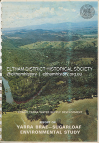
Book, Melbourne Metropolitan Board of Works, Lower Yarra Water Supply DeVelopment: Report on Yarra Brae-Sugarloaf Environmental Study, April 1974
environmental study, melbourne metropolitan board of works, report, sugarloaf reservoir, water catchment area, water supply, yarra brae dam, yarra river valley -
 Bendigo Historical Society Inc.
Map - HUNTLY RESURVEY, 1873
Map: Huntly resurvey. Parish plan ( number 242 in Map Cupboard 1)map, bendigo, parish plan, huntly -
Bendigo Historical Society Inc.
Map - MUSKERRY, No date visible
Map: Parish of Muskerry. Parish plan (number 310 in map cupboard 1)map, parish plan, muskerry -
 Warrnambool and District Historical Society Inc.
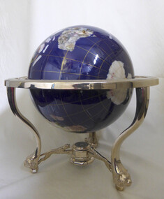
Decorative object - Trophy, World globe horseracing trophy
Won by thoroughbred horse Mega Pixel at the Warrnambool May carnivalLarge sphere map of the world. Blue in colour with world map. Supported on standwarrnambool, horse racing, globe, may carnival, mega pixel -
 Melbourne Tram Museum
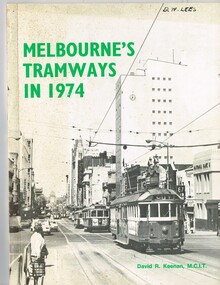
Book, David R. Keenan, "Melbourne's Tramways in 1974", 1974
... Maps ...Book, 48 pages + card covers + fold out map at rear, perfect bound, titled "Melbourne's Tramways in 1974". Written by David R. Keenan, published by the Transit Press NSW. Provides an overview of the Melbourne tram system at the transition point from being operated only by W class trams, to the start of operation of Z class trams. Gives a brief description of the system, the Board, trackwork, power supply, maintenance, Hawthorn Training Centre, tramway operations, fares, services in the CBD and from each of the depots. Has detailed map of the City area tramways and the suburban area, along with many photographs of the time."D. W. Lees on the top right hand corner on the front page in a fine felt pen ink.trams, tramways, mmtb, power supply, training, hawthorn, operations, maps, fares, depots -
 Montmorency–Eltham RSL Sub Branch
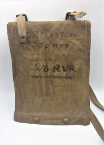
Equipment - Map Case No. 2, 1942
This 1942-dated Map Case was still in use post-1982 when it was used by a member of the 5/6 Royal Victoria Regiment. This new Melbourne-based battalion was created on the 17 August 1982. Open-sided with a khaki canvas flap attached to a resin-impregnated board.. Hinged to the top edge is a celluloid cover. Four clips holds the cover (and any map) to the backing board. The flap is secured by a pair of Carr Australia press studs on the back. The underside of the flap has four loops for chinagraph pencils and a wider pocket and loop for a Protractor. Two brass buckles are provided for a web shoulder sling. C. G. Hartley & Co. 1942 ORMISTON 3200879 5/6 RVR -
 Bacchus Marsh & District Historical Society
Map, Trentham Parish Map 1905 Copy 1
A single page paper map showing the map for the Parish of Trentham in the Counties of Dalhousie and Bourke. A cadastral map showing parish boundaries and land ownership. The map is pasted into a bound volume containing 76 maps or plans in total. High resolution digital image stored on BMDHS computer network. Photo-lithographed at the Department of Lands and Survey, Melbourne by T.F. McGauran 22.3.05 trentham parish maps, trentham parish plan, bacchus marsh region parish plans -
 Bendigo Historical Society Inc.
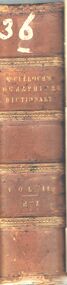
Book - A DICTIONARY GEOGRAPHICAL, STASTISTICAL, AND HISTORICAL. VOL. II
... maps ...A hard covered book titled, '' A Dictionary, Geographical, Statistical, and Historical, of the various countries, places, and principal natural objects in The World. Illustrated with maps. By J.R. McCulloch, Esq. Member of the Institute of France. A new edition revised, with a supplement. In two volumes. Vol. II. London : Longman, Brown, Green, and Longmans. MDCCCLIV.'' Handwritten in ink is the number 36. 983 pgs. (maps)J.R. McCulloch, Esq.book, geography, book, books, reference, geography, stastistics, history, world, maps, europe, world, place, dictionary, dictionaries, encyclopaedia, eaglehawk publlic library -
 Melbourne Tram Museum
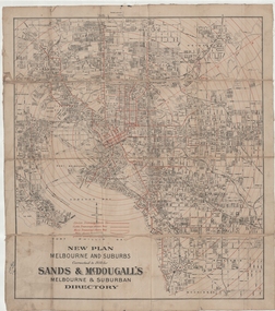
Map, Sands McDougall, "New plan Melbourne and Suburbs Sands & McDougall's Melbourne and Suburban Directory", 1910
... maps ...Shows railways, horse, cable and electric tram lines c1910. One of a number of maps produced by Sands McDougall of Collins St. Includes the MTOCo zoo horse tram lines, the NMETL and VR lines, but not the PMTT. Includes the Caulfield Elsternwick horse tram lines. Possibly included in Sands and McDougall directories based on the title. See items 2885, 6573 and 6916 for other editions. Yields information about Melbourne c1910 and its public transport lines. Cloth-backed and folded sheet of paper 5 sections wide x 4 sections or folds deep. Produced by Sands and McDougall Pty Ltd of Collins St Melbourne. maps, melbourne, cable trams, tramways, railways, horse trams, nmetl, vr trams, sands mcdougall, zoo horse tramway -
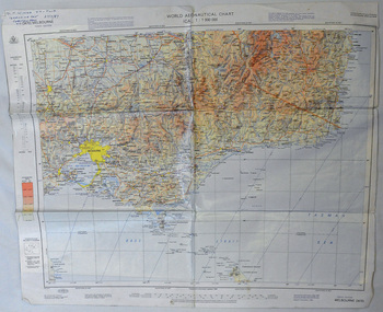 Orbost & District Historical Society
map, 1985
An aeronautical chart is a map designed to assist in navigation of aircraft. Using these charts and other tools, pilots are able to determine their position, safe altitude, best route to a destination, navigation aids along the way, alternative landing areas in case of an in-flight emergency, and other useful information such as radio frequencies and airspace boundaries. World aeronautical charts have a scale of 1:1,000,000 and cover relatively large areas. Orbost Aero Club began in 1969 with Basil Dowie as Chair, David Nixon as Secretary/Treasurer. The group went into recess from 1977-1991 closing in 1997. The mid 1960s were boom years in flying training in Australia and the number of Aero Clubs grew rapidly. The Club played a significant role in the establishment of the small airport at Marlo and in the ongoing operation and development of the airport over the years particularly for patient transfer by aerial ambulance. The Orbost Aero Club Club played a significant role in the establishment of the small airport at Marlo and in the ongoing operation and development of the airport over the years.A laminated map of eastern Victoria. A World Aeronautical Chart. It shows elevations, longitude etc and is designed for pre-flight planning as well as pilotage. Top left hand corner - D.F.N.Nixon VH-FWD 12 Kristine Ct Cheletenham 27/7/87orbost-aero-club aeronautical-map -
 Greensborough Historical Society
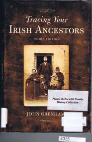
Book, Gill & Macmillan et al, Tracing your Irish ancestors, 3rd ed. John Grenham, 2006_
Hints on tracing Irish ancestors.526p., maps.family history, genealogy -
 Greensborough Historical Society
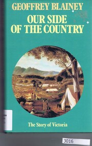
Book, Geoffrey Blainey et al, Our side of the country / Geoffrey Blainey, 1991_
A short history of Victoria.226p., maps.victoria history -
 Federation University Historical Collection
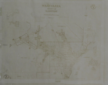
Map, Waanyarra, not dated
Photocopy of mapwaanyarra -
Creswick Campus Historical Collection - University of Melbourne
Map, 1923
Creswick proposed extension, 25-5-1923.Cloth map -
Peterborough History Group
Document - District families and organisations
Local families' history, school, post officephotocopies, mapspeterborough history, croft family, thomas croft, peterborough post office, wallaby hill school, peterborough school -
Melbourne Athenaeum Archives
Booklet, Walking the City of Literature / A Literary Map of Melbourne, 2017
Athenaeum library is listed Booklet / MapMarkings of Melbourne's Bookstores and Libraries. athenaeum library, melbourne -
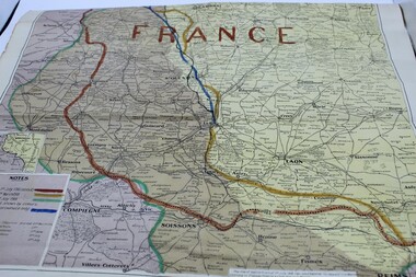 Ringwood RSL Sub-Branch
Souvenir - Map of France, Battlefront lines marked on map.1918
Map of France -
Whitehorse Historical Society Inc.
Document, Box Hill History Kit
Box Hill History Kit published by Box Hill Historical Society and Box Hill City Council.Box Hill History Kit published by Box Hill Historical Society and Box Hill City Council. Contents include Brochures, First Box Hill Railway Time Table, copies of Box Hill & Doncaster Tramway Tram and old photos taken around Box Hill, Tom Roberts Artists' Camp, 1905 Map of Box Hill etc.Box Hill History Kit published by Box Hill Historical Society and Box Hill City Council. box hill historical society, box hill city council -
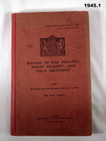 Bendigo Military Museum
Manual - TRAINING SERIES, 2), .3), & .4) Her Majesty's Stationery Office, Manual of Map Reading, Photo Reading, and Field Sketching, 1) 1929, Reprint 1939; .2) 1955; .3) 1957; .4) 1958
Training Manuals - War Office London 1920 - 1939. .1) Red coloured cardboard with red coloured buckram, spine, black print on front & Coat of Arms. 166 pages, cut, plain, off white paper with black & white & coloured maps & diagrams. .2), .3) & .4) Red coloured cardboard with red coloured buckram, spine, black print on front. Cut, plain, off white paper with black & white & coloured maps & diagrams. .2) 132 pages. .3) 80 pages. .4) 69 pages. .1) “1929 Reprinted with amendments No's 1 to 4 1939” .2) “1955 Part 1 Map Reading” .3) “1957 Part III Field Sketching” Front fly leaf in red ballpoint pen: “S Sgt Moore / LAD” .4) “1958 Part II Air Photo Reading”books-military history, technical, documents - maps -
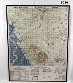 Bendigo Military Museum
Map - MAP, MOUNTED, US Army 1966, Map information as of 1965
Map - colour map titled "XA BINH BA, VIETNAM" Scale 1:50,000. Map depicts "ENEMY INSTALLATIONS 1 APR - 22 OCT 68, CONFIDENTIAL" Map mounted on sheet of timber, sealed with a clear varnish.mapping, vietnam war -
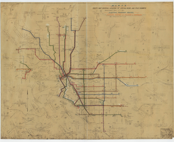 Melbourne Tram Museum
Drawing, Melbourne & Metropolitan Tramways Board (MMTB), "Route Map showing location of special work and pole numbers" "Electric Tramway Routes - showing routes in colours and numbers", late 1941
Map of the system shown at two inches = 1 mile. Drawing No. P5799. Shows crossovers, track layouts at junctions, signal cabins roads, railways and stations. Originally signed by Perway Engineer - 20/12/1940, though originally drawn in 1922. Has been marked up in coloured pencil to show the routes and route numbers. The plan shows the lines to Maribyrnong Munitions works along Cordite Ave and Wests Road and the track from Moonee Ponds to Union Road, which opened in July 1941, but not the extension to Essendon Airport built-in 1942. See Reg Item 1561 for a 1963 version and 1683 for a 1987 versionDemonstrates the use of a MMTB drawing to show tram routes and their route numbers at the time.Drawings - dyeline cloth backed print - titled - "Route Map showing location of special work and pole numbers" and subtitled - "Electric Tramway Routes - showing routes in colours and numbers". trams, tramways, mmtb, trackwork, tramways, junction, map, world war 2 -
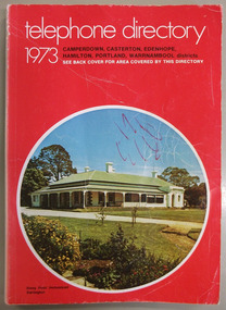 Warrnambool and District Historical Society Inc.
Book, Telephone Directory 1973, 1973
The numbers listed in this directory are under the heading of districts and the listings within the districts are again sub-listed under the various towns. So in the Warrnambool district there are listings under Winslow, Panmure, Orford, Port Fairy. Wangoom etc.This directory is of some importance as the names and addresses of those with telephones in 1973 in the local areas are listed. Most of the listings of the smaller towns give the names of the homes and properties. So this is a very useful tool for research purposes.This is a soft cover booklet with a red cover and an oval-shaped insert colour photograph of Stony Point Homestead, Darlington, on the front cover and a map of the telephone area on the back cover. Front cover – Telephone Directory 1973, Camperdown, Casterton, Edenhope, Hamilton, Portland, Warrnambool districts. See back cover for area covered by this directory Spine – Camperdown, Casterton, Edenhope, Hamilton, Portland, Warrnambool districts. See the pink pages for business & trade listings. VI- 1973 Back Cover – Country directory areas. The area covered by this Directory is the coloured portion of this map. See the pink pages for business and trade listings. warrnambool, warrnambool telephone directory 1973 -
Bendigo Historical Society Inc.
Map - CAMPBELL COLLECTION: PARISH MAPS
BHS CollectionNineteen Parish maps of Bendigo area in a plastic bag. Mostly original maps. Copies or originals of all maps are available to access in the Map Cupboard. Not catalogued separately. Maps come from Don Stewart, 10 Avery's Rd. Eaglehawk. Don now deceased. He worked in a Government job in bendigo. -
Federation University Historical Collection
Map, Robinson's Ballarat Street Map, c1972, 1970s
A coloured fold-out street map of Ballarat. It also includes a district road map.ballarat, map, ballarat streets