Showing 11155 items matching "planning "
-
 Bendigo Historical Society Inc.
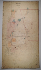
Map - REDCASTLE AND DARGILE, No date visible
Map: Redcastle and Dargile. Parish planPencil markings 27/6/78, 18/10/78map, parish plan, redcastle, dargile -
![Map, Plan of Subdivision of Crown Portion 23 & parts 24-25, Parish of Korkuperrimul [1900s?]](/media/collectors/5e461d8021ea67224c82f2a1/items/675fe058304668462205d4fb/item-media/675fe0ef304668462205d7d6/item-fit-380x285.jpg) Bacchus Marsh & District Historical Society
Bacchus Marsh & District Historical SocietyMap, Plan of Subdivision of Crown Portion 23 & parts 24-25, Parish of Korkuperrimul [1900s?]
The Parish of Korkuperrimul includes a significant section of the township of Bacchus Marsh and extends in western and northern directions from the township area. The date of the subdivision indicated on this plan has not been established. The engineer's stamp on the drawing shows the firm of Muntz and Muntz who were operating under that name in the early part of the 20th century.A single page paper map showing 20 blocks of land for sale in the Parish of Korkuperrimul. Scale 100 feet to 1 inch. The map is pasted into a bound volume containing 76 maps or plans in total. High resolution digital image stored on BMDHS computer network. Stamped: 'Muntz & Muntz Civil Engineers, Architects & Surveyors, Trustees Chambers ?? Cor Collins Street and Bank Placeland sales bacchus marsh, bacchus marsh victoria maps, land sales korkuperrimul parish -
 Federation University Historical Collection
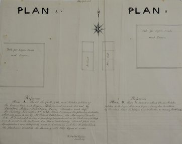
Plans, Site for Engine House and Engine, 1887
Two ink plan drawings, one with brown and grey shading, showing proposed sites and relative positions for an engine house and engine. .1) shows Plan A and Plan B options .2) shows elevations of brick engine houseengine house, robert ditchburn, w. watson, plans, mining -
 University of Melbourne, Burnley Campus Archives
Work on paper (item) - Student Work, Sandra Brizga, Andembach - Riverside Garden Planting Plan, 8 November 2018
Made as an assignment for HORT90035, a subject at Burnley Horticultural College coordinated by Andrew Laidlaw. assignment, burnley horticultural college, hort90035 -
 University of Melbourne, Burnley Campus Archives
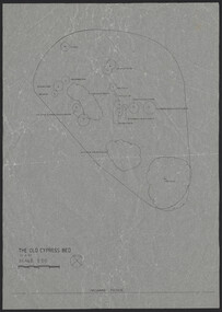
Plan, The Old Cypress Bed, 1987-1993
(1) Plant plan dated 15.8.1987 on tracing paper, and plan of bed only. (2) Site inventory and analysis Group 3 Parks and Gardens III August 1993, on tracing paper. (3) Rough plant plan in pencil.gardens, cypress, burnley gardens 150 year anniversary -
University of Melbourne, Burnley Campus Archives
Plan, Burnley College Site, c. 1970 - 2001
Miscellaneous plans of the Burnley site with enlargements of sections. Roughly sorted. Different periods. Includes a map of Kew, and part of plan of Charman Ave., Emerald. Annotated plan of area of glass houses and chicken test pens ((1970 - 80?)burnley college, gardens, college buildings, kew, emerald -
 Kew Historical Society Inc
Plan - Subdivision Plan, J R Mathers & McMillan, Plan of Subdivision of Part of Crown Portion 83 at Kew : LP6669, 1923-1939
In 1888, in the section of Park Hill Road between Belmont Avenue and Normanby Road there was only one street running between Park Hill Road and Cotham Road. This was Park Road, later to be named Adeney Avenue. Subsequent 20th century subdivisions created the ‘through roads’ of Cecil Street, Wimba Avenue, Florence Avenue, Marshall Avenue, Uvadale Road, and Barrington Avenue. This subdivision represents an attempt by auctioneers, rather than town planners to create an urban environment from larger residential allotments or in many cases farmland. Existing streets such as Parkhill and Normanby Roads provided a convenient starting point for the surveyors, but the Road named ‘Street Street’ indicates the role of the private surveyor in creating streets. Given that a number of allotments are listed as sold on the plan, the street is presumably Cecil Street. Even those lots that had been sold do not quite match the dimensions of the blocks in this parcel of land today, indicating that either further subdivisions or boundary alterations occurred.Subdivision plans are historically important documents used as evidence for the growth of suburbs in Australia. They frequently provide information about when the land was sold as well as evidence relating to surveyors and real estate and financial agents. The numerous subdivision plans in the Kew Historical Society's collection represent working documents, ranging from the initial sketches made in planning a subdivision to printed plans on which auctioneers or agents listed the prices for which individual lots were sold. In a number of cases, the reverse of a subdivision plan in the collection includes a photograph of a house that was also for sale by the agent. These photographs provide significant heritage information relating house design and decoration, fencing and household gardens.The photograph may also be aesthetically significant depending on the importance of the photographic atelier.Hand-drawn subdivision plan of 19 lots facing Parkhill Road, Normanby Road, and an unnamed street [now Cecil Street] in Kew.Estate Agent notes in ink indicate those lots which had sold.subdivision plans - kew, parkhill road - kew, cecil street - kew, normanby road - kew, cecil street -kew, parkhill road - kew, normanby road - kew, crown portion 83 - kew -
 Whitehorse Historical Society Inc.
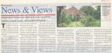
Article, Walker Estate, 22/11/1997 12:00:00 AM
Luther College Year 10 History assignment Residents in Mitcham are fighting to save one of their suburb's historic homes.Residents in Mitcham are fighting to save one of their suburb's historic homes. More than 60 objections have been received by the City of Whitehorse Planning Office to an application by Metrospan Developments to build 16 double storey units at 456 - 460 Mitcham Road, Mitcham. The proposed development is on part of the historic Walker Estate.Luther College Year 10 History assignment Residents in Mitcham are fighting to save one of their suburb's historic homes. walker estate, hogg, tony, australian tesselated tile co. pty ltd, allan, peter, buckingham, helen, rigo, anthony, metrospan developments -
 Warrnambool and District Historical Society Inc.
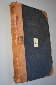
Ledger, Letter book 1892-1904, 1892
This letter book has letters, sketch maps and plans and dates from 1892 to 1904. It came from the office of John William Crawley, Junior, an engineer, architect and surveyor in private practice in Warrnambool and also the engineer of the Shire of Warrnambool from 1895 to 1935. His father, brother and son were also engineers and worked in that capacity or as the Shire Secretary for the Shire of Warrnambool, with the Crawley family recording a total of 132 years of service to the Shire. This letter book was passed on to John Crawley’s son, Rolf Crawley, Engineer for the Shire of Warrnambool from 1935 to 1968. The letter book then came into the possession of Michael Hand who took over the private surveying business of Rolf Crawley in Warrnambool. The Warrnambool and District Historical Society has acquired the letter book, one of several Crawley ledgers, from the Michael Hand estate. This letter book is of considerable significance as it contains maps, plans, sketches and written information which is the work of John William Crawley Junior, the engineer for the Shire of Warrnambool for 40 years. It will be very useful to researchers. This is a hard cover letter book of 500 pages. The cover is black with leather binding on the edges of the cover and on the spine. The pages contain an alphabetical listing of the letters, handwritten letters and many sketch maps and plans. There are several loose pages of plans and diagrams at the back of the book. The inside of the covers has a blue mottled pattern. The edges of the cover are torn. There is a mauve stamp on the first page. ‘Letter Book 1892 to 1901’ ‘Rolf L. Crawley, Civil Engineer, Drainage and Water Supply Engineer, Licensed Surveyor, Registered Architect, Warrnambool’ john william crawley, junior, warrnambool, rolf crawley, warrnambool, shire of warrnambool -
 Bendigo Historical Society Inc.
Map - Marong County of Bendigo
Map of Marong. Drawn and reproduced at the Dept. of Lands and Survey, Melbourne. By authority: W.M. Houston Government Printer. June 1953.On the back in blue pen: certified plan parish Marong, signed minister and seal affixed for land S sec.72 evidence act. I certify that this a true plan parish Marong (signature illegible) minister for lands.map, marong -
 Melbourne Tram Museum
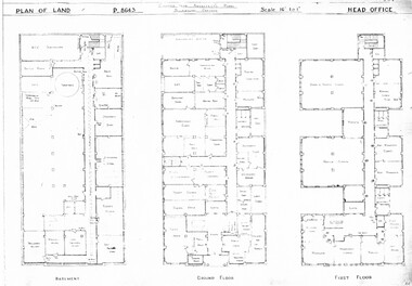
Drawing, Melbourne & Metropolitan Tramways Board (MMTB), "Head Office", c1938
Set of three photocopied plans or drawings on A3 sheet of "Head Office" - c1937 .1 - P8643 - Plan showing Basement, Ground Floor and First Floor - shows MCC substation location in basement. .2 - P8644 - Plan showing Second, Third and fourth floors .3 - P8394 - Plan showing firth floor and roof, with lift rooms.trams, tramways, drawings, depots, property, head office, mmtb, substation -
 Bendigo Historical Society Inc.
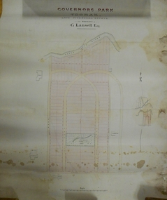
Plan - MARKS COLLECTION: PLAN OF G. LANSELL'S GOVERNOR'S PARK, TOORAK
Plan (tightly rolled) drawn on heavy paper mounted on fabric. On top of plan printed 'Governor's Park Toorak, late Vice-Regal Estate, the property of G. Lansell Esq' On top of plan Yarra River, on bottom Toorak Road, Plan shows subdivision, in centre of which is drawn outline of 8 acres containing the 'Mansion and Grounds'.bendigo, hospital -
 Lakes Entrance Historical Society
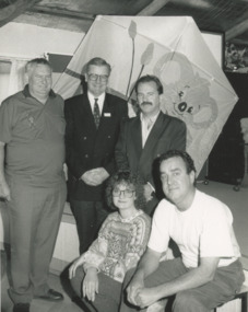
Photograph - Peter Hogan ,Duncan Harris, Brendan Downey, Glenda Nixon, Gary Lyons, Lakes Post Newspaper, 1/10/1994 12:00:00 AM
committee pre planning for World Cup Sport Kite event Peter Hogan Total Events Promotion, Duncan Harris Oceania Receptive Brendan Downey Tourism Victoria Glenda Nixon World Cup Organiser Gary Lyons Committee Lakes Entrance VictoriaBlack and white photograph showing members of committee pre planning for World Cup Sport Kite event Peter Hogan Total Events Promotion, Duncan Harris Oceania Receptive Brendan Downey Tourism Victoria Glenda Nixon World Cup Organiser Gary Lyons Committee Lakes Entrance Victoriasports, kites, events -
 Kew Historical Society Inc
Plan, F R Simms & Son, Land for Private Sale: Cnr Victor Avenue and Mont Victor Road, Kew, 1950-1960
George Rimington established The Parkhill Nursery in 1877. By 1910, it was more commonly known as Rimington’s Nurseries and well known for its sale of violets. After World War II, Rimington’s Nurseries were gradually subdivided and sold. The 38 allotments were released in sections, including lots 34 to 36 on the corner of Mont Victor Road and Victor Avenue. Previous lots in the subdivision had bordered Burke Road, Rimington Avenue, Heather Grove, and Stoke Avenue. The selling point as it had been in comparable estates for a century were the proximity to transport, schools and churches, as well as the high location and excellent views. The subdivision plan shows most of the lots in the entire subdivision: 1-11, 13-26, and 34-38. Presumably, lot 12 and lots 27-33 were still to be released.Subdivision plans are historically important documents used as evidence of the growth of suburbs in Australia. They frequently provide information about when the land was sold on which a built structure was subsequently constructed as well as evidence relating to surveyors and real estate and financial agents. The numerous subdivision plans in the Kew Historical Society's collection represent working documents, ranging from the initial sketches made in planning a subdivision to printed plans on which auctioneers or agents listed the prices for which individual lots were sold. In a number of cases, the reverse of a subdivision plan in the collection includes a photograph of a house that was also for sale by the agent. These photographs provide significant heritage information relating house design and decoration, fencing and household gardens.Subdivision plan advertising five superb home sites among lots in Burke Road, Stoke Avenue, Victor Avenue, Mont Victor Road and Heather Grove.subdivision plans - kew, rimington avenue -- kew (vic.), heather grove -- kew (vic), stoke avenue -- kew (vic.), burke road -- kew (vic.), mont victor road -- kew (vic.) -
 Ringwood and District Historical Society
Manual, Southwood Primary School, Ringwood - Evacuation Procedure Manual (undated - circa - post 1983)
Bound Manual describing evacuation and emergency procedures. Includes Action Plan, Staff members, Instructions, Types of Threats and school building plan -
Lara RSL Sub Branch
Education Package, Anzac Centenary Corcmmunity Resource Guide
The Community Resource Guide helps you plan a commemorative event in Victoria and share Local stories as part of the planning for ANZAC Centenary celebrationsPart 1 includes elements of a commemorative service and preserving precious memorabilia Part 2 includes Victoria's roll in the History of World War One. Also included are capsule stories of the men who were awarded the Victoria Cross for outstanding valour -
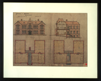 Federation University Historical Collection
Drawing - Architectural Drawing, Plans for the Ballarat School of Mines New Classrooms, c1899 (print), c1899
The new classrooms at the Ballarat School of Mines were started in 1899 and completed in 1901. In 2014 this building is known as The Administration Building on the Federation University Australia SMB Campus.Framed print of original plans for new double storey classrooms at the Ballarat School of Mines. The plans include the front elevation and a side section.ballarat school of mines, buildings, administration building, new classrooms, prov, plans, architecture, architectural drawings, a building -
Clunes Museum
Document - REPORT, NADIA GASPARETTO et al, CLUNES TOWN HALL AND COURT HOUSE CONSERVATION PLAN, MAY 2000
THE HISTORY AND CONSERVATION POLICY IS AIMED AT RETAINING AND CONSERVING THE BUILDINGCONSERVATION PLAN OF CLUNES TOWN HALL AND COURT HOUSE COMPILED BY NADIA GASPARELTO , ARCHITECT AND HEPBURN SHIRE COUNCIL, INCLUDING PLAN OF BUILDINGLIST OF ILLUSTRATIONS AND PHOTOSclunes town hall, clunes courthouse -
Whitehorse Historical Society Inc.
Article, Council services awards, 1996
Whitehorse Council has received a commendation award for planning excellence from the Royal Australian Planning Institute for the review of the community grants program.Whitehorse Council has received a commendation award for planning excellence from the Royal Australian Planning Institute for the review of the community grants program.Whitehorse Council has received a commendation award for planning excellence from the Royal Australian Planning Institute for the review of the community grants program.city of whitehorse, awards, royal australian planning institute -
Whitehorse Historical Society Inc.
Map, Anjaya Court, Blackburn, ca1970
[Plan of] Anjaya Court, Blackburn, Lots 6 - 20and of Leons Court, Lots 21-24. One copy with proposed sewerage plan.anjaya court, blackburn, land subdivision, sewerage and sanitation -
 Bendigo Historical Society Inc.
Document - BERT GRAHAM COLLECTION: BENDIGO EAST SWIMMING CLUB
Plans, Bert Graham Collection, Bendigo East Swimming Club, Plan for the construction of the Kiosk. This item quite large and has not been scanned.bendigo, clubs, bendigo east swimming pool -
 Bendigo Historical Society Inc.
Plan - BERT GRAHAM COLLECTION: BENDIGO EAST SWIMMING POOL
Plans, Bert Graham Collection, Bendigo East Swimming Pool, 2 plans for the Kiosk. This item is quite large and has not been scanned.bendigo, clubs, bendigo east swimming pool -
 Bendigo Historical Society Inc.
Plan - BERT GRAHAM COLLECTION: BENDIGO EAST SWIMMING POOL
Plans, Bert Graham Collection, Bendigo East Swimming Pool, plans for the Pool. 4 quite large sheets too big to scan.bendigo, clubs, bendigo east swimming pool -
University of Melbourne, Burnley Campus Archives
Plan - Photocopy, Jan Horner, 24 Selbourne Road Toorak Concept Plan, 2000
Photocopy of plans by Jan Horner, 16 December 2000. Scale 1:50. (1) Concept Plan. (2) One Point Perspective.jan horner, toorak, garden design -
University of Melbourne, Burnley Campus Archives
Work on paper (item) - Student Work, Annabel Dungey, Birch Tree Residence Project, 2018
assignment, burnley horticultural college -
University of Melbourne, Burnley Campus Archives
Work on paper (item) - Student Work, Perry Lane, Glenlyon RD Landscape Design, Uncertain, probably 2017-2018
Submitted as an assignment for HORT90035, 'Landscape Construction and Graphics,' a subject at Burnley Horticultural College coordinated by Andrew Laidlaw. It seems a third sheet of paper is missing, though one of the folders does contain a rubric showing the mark received for this project. assignment, landscaping, burnley horticultural college, landscape construction and graphics, hort90035 -
Canterbury History Group
Ephemera - A magical reminder of an enchanting era, 1991
Real estate advertisement for the sale by auction on 9 September 1991 of 138 Canterbury Road Canterbury. Includes floor plans and site plans.canterbury, canterbury road, marlowe street, federation style -
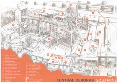 Bendigo Historical Society Inc.
Document - CENTRAL DEBORAH GOLD MINE: PLAN OF SURFACE FEATURES OF MINE
BHS CollectionTwo copies of a plan of the Central Deborah Gold Mine. Features on the surface of the mine are drawn, labelled and described. Plan printed in orange and grey.bendigo, mining, central deborah gold mine -
 Kew Historical Society Inc
Plan - Subdivision Plan, Kew Golf Links Estate, 1936, 1936
The Kew Golf Links Estate was a major subdivision in North Kew. It derived its title due to the land being previously occupied by the Kew Golf Club, which transferred its course to a number of locations before occupying its current site. The Plan advertises 180 choice home sites. The street names are somewhat different today as those on the map are named after the proposed Kodak Factory to be built on the site. The subdivision of the Kew Golf Links Estate was a major subdivision of farmland in Kew. The site was at one stage designated for industrial development and the building of a new Kodak factory. The decision by Council to oppose the redevelopment makes the beginning of the period when all industrial development was banned in Kew.Monochrome printed, folded subdivision plan for the Kew Golf Links Estate, to be auctioned on 7 November 1936. Streets named include: Carnegie Avenue, Willsmere Road, Kilby Boulevarde, Kodak Avenue, Coleman Avenue, Beresford Avenue, McConchie Avenue, Cole Avenue, White Avenue, Baker Avenue, Spruzen Avenue, Tanner Avenue, Ratten Avenue, Mathers Avenue, Railway Avenue, Sutherland Avenue, and Belford Road. The position of the Yarra River and a large Drainage Reserve are marked on the plan. Lots for sale are numbered. Existing buildings are designated with a square.subdivision plans - kew (vic), kodak factory - kew (vic) -
Whitehorse Historical Society Inc.
Article, A Living, working view of our heritage, 1992
Matheson's Orchard, the last working orchard in NunawadingMatheson's Orchard, the last working orchard in Nunawading will soon be open to the public. Council purchased the orchard in 1988. The plan is to run the orchard as it would have operated in the 1930's providing a living and working view of Nunawading's heritage. The eldest child, Marjory, wife of Rev Rhys miller is writing a history of the orchard for Council.Matheson's Orchard, the last working orchard in Nunawading orchards, matheson, charles, city of nunawading