Showing 112729 items
matching tracks/roads
-
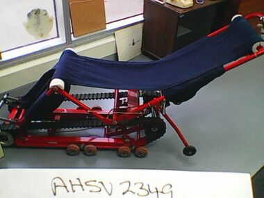 Ambulance Victoria Museum
Carry chair
Used in the 1980s and designed to facilitate the movement of patients down stairs and into ambulances. Item was not carried in ambulances and had to be delivered to incident site when required. Item was not a success and ambulance officers continued to use chairs to move patients down stairs. Source Chas Martin AHSV curator 7 November 2016Red metal tracked chair with blue canvas seat. -
 Southern Sherbrooke Historical Society Inc.
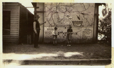
Booklet, "The Hiker's Handbook Of Wonderful Walks In Victoria", May-36
Photocopy of 1936 booklet detailing walking tracks in Victorialockwood, belgrave, selby, narre warren, dandenong reservoir -
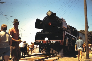 Bendigo Historical Society Inc.
Slide - BENDIGO- TRAIN IN TOWN, Feb 1970
Slide. Bendigo- Train in Town. Engine R766 on track.slide, bendigo, bendigo- train in town. -
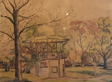 Surrey Hills Historical Society Collection
Watercolour Painting, The Rotunda in the Surrey Gardens,1966, 1966
The rotunda in the Surrey Gardens was built in 1912 and demolished in the early 1970's. The rotunda was dedicated to John Gray in appreciation of his service to the community. The watercolour was painted in 1966 by Miss Barker of Union Road. The artist may be Valerie Jean Barker of Unit 5, 246 Union Road. (REF: 1963 electoral roll). There is no knowledge of the identity of the lettering in the lower right hand corner of the painting. The medium is grey lead ink and watercolour. Framed watercolour of the rotunda in Surrey Gardens painted circa 1966. The medium is grey lead ink and watercolour.On the back: "The Rotunda in the Surrey Gardens, 1966/, Ink and watercolour by Miss Barker of Union Road, Surrey Hills/ [Could be Valerie Jean Barker, 5/246 Union Road - ref:1963 electoral roll]" -
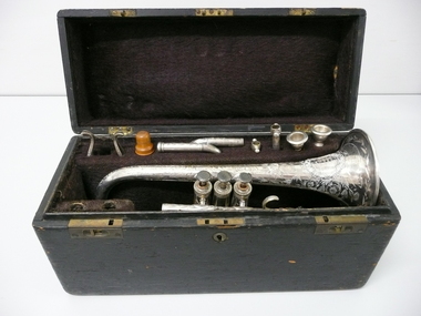 Bendigo Historical Society Inc.
Instrument - JAMES NORTHCOTT COLLECTION - CORNET
a. Black wooden case, brass handle on top of lid, brass hinges and lock, lined with black ( faded) velvet. B. Cornet, engraved with leaves and flowers. Engraved on top ' F. Besson, Brevetee, 198 Euston Road, London.' On bell ' Presented by the citizens to James Northcott Bandmaster of the Sandhurst Volunteer Band in recognition of his musical abilities. Sandhurst Dec. 8 1871. Cornet box contains 7 additional parts of the Cornet. ( see photo )F. Besson, Brevetee, 198 Euston Road, Londonmusical instruments, wind, cornet ( besson ), james northcott, sandhurst, volunteer band, bendigo, music, presentation -
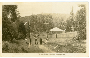 Mt Dandenong & District Historical Society Inc.
Photograph, The Road To The Falls Mt. Dandenong. Vic, early 1900s
Postcard showing two men and two women standing on Falls Road and two girls sitting on the grassy bank. This section of Falls Road would be below the current Tourist Road. A long fence has been built on the LHS and a house with a verandah is clearly seen. Early 1900s. The postcard appears to have been sent to Jim Woolrich from Auntie Florrie.On front of postcard: THE ROSE SERIES #152 THE ROAD TO THE FALLS, MT. DANDENONG. VIC. On back of postcard: Mr J Woolrich 58 Mountfield St Brunswick Wishing you many happy returns of the day from Auntie Florrie. falls road, olinda falls, mt dandenong, rose series -
 Whitehorse Historical Society Inc.
Pamphlet - Advertising brochure, Arlington Estate
Estate Agent's advertising brochure for Arlington Estate,Estate Agent's advertising brochure for Arlington Estate, Blackburn including Molleton Street. Baldwin Street and Canterbury Road.Estate Agent's advertising brochure for Arlington Estate,arlington estate, blackburn, molleton street, canterbury road, baldwin street, land subdivision -
Whitehorse Historical Society Inc.
Article, Traffic works, 1/06/1994 12:00:00 AM
Nunawading Gazette article dated 8 June 1994.Nunawading Gazette article dated 8 June 1994 about traffic works at Blackburn and Railway Roads intersection.Nunawading Gazette article dated 8 June 1994. roads and streets, blackburn road, blackburn, railway road, blackburn -
Whitehorse Historical Society Inc.
Article, Lasting memories, 2012
50th Anniversary reunion of the Mitcham and Heatherwood Special Schools50th Anniversary reunion of the Mitcham and Heatherwood Special Schools on 12 October 2012 at 370 Springvale Road Donvale.50th Anniversary reunion of the Mitcham and Heatherwood Special Schools heatherwood special school, mitcham special school -
Bendigo Historical Society Inc.
Document - A WEE BOOK ABOUT WEE GEORGIE, c1905
A Wee Book about Wee Georgie, a Souvenir of his Australian Tour.The embodiment of Peter Pan. J. L.. Anderson and Sons Pty Ltd Print, 63 City Road, Melbourne. The program is autographed by George Wood. Tour took place between c1905 and 1920.J. L. Anderson and Sons Pty Ltd Print, 63 City Road, Melb.program, theatre, a wee book about wee george wood, a wee book about wee georgie, a signed souvenir program of his australian tour. tour took place between c1905 and 1920 -
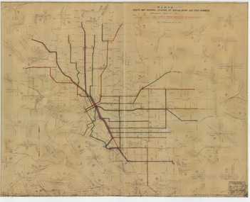 Melbourne Tram Museum
Drawing, Melbourne & Metropolitan Tramways Board (MMTB), "Route Map showing location of special work and pole numbers" "All night tram routes in colours", late 1941
Map of the system shown at two inches = 1 mile. Drawing No. P5799. Shows crossovers, track layouts at junctions, signal cabins roads, railways, and stations. Originally signed by Perway Engineer - 20/12/1940, though originally drawn in 1922. Has been marked up in colour pencil to show the all-night routes and the individual services. The plan shows the lines to Maribyrnong Munitions works along Cordite Ave and Wests Road and the track from Moonee Ponds to Union Road, opened in July 1941, but not the extension to Essendon Airport built in 1942.Demonstrates a detail drawing of Melbourne tramways, junctions and pole numbers.Drawings - dyeline cloth-backed print - titled - "Route Map showing the location of special work and pole numbers" and subtitled - "All night tram routes in colours". trams, tramways, mmtb, trackwork, tramways, junction, map, world war 2, night trams -
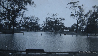
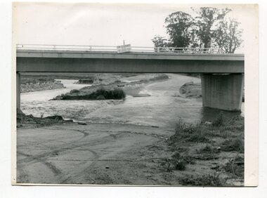 Orbost & District Historical Society
black and white photographs, October 22 1976
The road to Marlo was cut by flood waters from the Snowy River in two places. The road was closed when water flowed over Gilbert's Gulch (3243.1) The Snowy River broke its banks and flooded surrounding Orbost, Marlo, Lochend and Jarrahmond were isolated. The river bank at the bridge site was broken and filled with earth and rock fill. (3243.2) The new Snowy River Bridge was nearing completion when the river rose 7.2 metres causing erosion on the eastern bank. (3243.7) Contractors involved in the construction of the Princes Freeway and bridge were delayed by the flood waters. (3243.8) The 1976 flood at Orbost was a significant event which delayed the construction of the current Snowy River Road Bridge.These photographs record that event.Nine black / white photographs of flood waters across roads. orbost-flood-1976 snowy-river-bridge marlo-road-flood-1976 gilbert;s-gulch-flood -
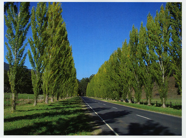
 Marysville & District Historical Society
Photograph (Item) - Colour photograph, Unknown
A colour photograph of Gould Memorial Drive which is on the Marysville-Buxton Road near Marysville in Victoria.A colour photograph of Gould Memorial Drive which is on Marysville-Buxton Road just outside Marysville in Victoria. The planting of the avenue of Lombardi Poplars was initiated by Mrs Joy Gould and the trees were planted by workers of the Gould Mill. The intention was for the avenue to extend from Marysville to Buxton. However, this was never fully realised. In Autumn the trees turn a brilliant yellow and are a major tourist attraction. john lloyd gould, joy gould, gould mill, gould memorial drive, marysville-buxton road, marysville, buxton, victoria, photograph, lombardi poplars -
 Marysville & District Historical Society
Photograph (Item) - Black and white photograph, 1949
A copy of a black and white photograph of an Atlantic Road Map of Marysville adhered to an unknown building in Marysville.A copy of a black and white photograph of an Atlantic Road Map of Marysville adhered to an unknown building in Marysville.marysville, victoria, maps, atlantic road map -
Marysville & District Historical Society
Document (item) - Letter, Andrew Kirwan mining-Wolfram & Gold at Cumberland River, 09-07-1981
A letter outlining the history of Andrew Kirwan who was a gold miner and road worker in Marysville in Victoria.A letter outlining the history of Andrew Kirwan who was a gold miner and road worker in Marysville in Victoria. Andrew Kirwan, along with his brothers, located and worked the Wolfram Mine at Wilkes Creek where they mined tungsten.andrew kirwan, marysville, victoria, cumberland valley, wolfram mine, wilkes creek, anderson and rowe sawmill, cumberland creek, golden bower gold mine, william chester, maria catherine kirwan, kirwan's reward, tungsten, cumberland river -
 Marysville & District Historical Society
Photograph (Item) - Black and white photograph, 05-02-1924
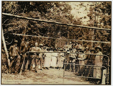
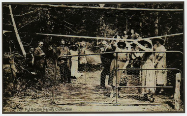
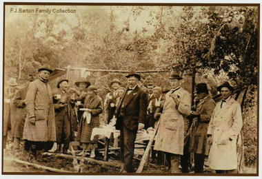
An early black and white photograph of the ceremonial re-opening of the Marysville-Wood's Point Road in 1924.An early black and white photograph of the ceremonial re-opening of the Marysville-Wood's Point Road in 1924. The Marysville-Woods Point Road was originally part of the Yarra Track, constructed in the early 1860s to provide access between Healesville and the Woods Point Goldfields. Despite the steep terrain and engineering difficulties, the Yarra Track soon became a busy route used by pack horses, horse-drawn drays, and wagons. Today this sealed mountain road is a popular scenic drive between Marysville and Warburton.F.J. Barton Family Collectionmarysville-wood's point road, marysville, wood's point goldfields, healesville, yarra track, warburton -
 Marysville & District Historical Society
Photograph (Item) - Black and white photograph, 05-02-1924
An early black and white photograph of the ceremonial re-opening of the Marysville-Wood's Point Road in 1924.An early black and white photograph of the ceremonial re-opening of the Marysville-Wood's Point Road in 1924. The Marysville-Woods Point Road was originally part of the Yarra Track, constructed in the early 1860s to provide access between Healesville and the Woods Point Goldfields. Despite the steep terrain and engineering difficulties, the Yarra Track soon became a busy route used by pack horses, horse-drawn drays, and wagons. Today this sealed mountain road is a popular scenic drive between Marysville and Warburton.F.J. Barton Family Collectionmarysville-wood's point road, marysville, wood's point goldfields, healesville, yarra track, warburton -
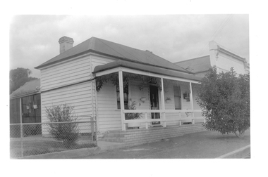 Tarnagulla History Archive
Photograph of cottage at 96 Commercial Road, Tarnagulla, Late 1960s
Murray Comrie Collection. Building is still on Commercial Road and in 2019 is a private residence. History to be confirmed.Monochrome photograph depicting a cottage with raised verandah, which is located at 96 Commercial Road, Tarnagulla.tarnagulla, commercial road, buildings, houses -
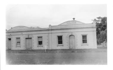 Tarnagulla History Archive
Photograph of former Victoria Hotel and Theatre, Tarnagulla, Former Victoria Hotel and Theatre, Tarnagulla, Late 1960s
Murray Comrie Collection. Building is still on Commercial Road and in 2019 is used as the town's public hall.Monochrome photograph depicting former Victoria Hotel and Theatre, which is located in Commercial Road, Tarnagulla.tarnagulla, commercial road, victoria hotel and theatre, buildings, houses -
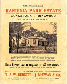 Ringwood and District Historical Society
Flyer, Land Sale Brochure, Kardinia Park Estate, North Ringwood, Vic. - circa 1948
Folded buff-coloured land sale advertisement for Kardinia Park Estate in Warranwood area of North Ringwood, including terms of sale, area map, layout plan of the estate, and summary of local facilities and services. Front page features photograph of a man and dog in front of a house captioned as Lot 1 on four acres shown on the estate layout as cnr of Brysons Road and Range View Parade (later Omeo Parade). Second page includes bushland swimming pool photograph and promotional information for prospective buyers.Subdivision includes Kardinia Crescent, Wonga Road, Brysons Road, Range View Parade (later Omeo Parade), Motor Coach Road (later Wonga Park Road, then Warranwood Road). (Agent/s) T.A.W. Burkitt, Main Street, Ringwood, Phone (9 to 6) Ringwood 242, Evenings, Ringwood 157, and J. McEwan & Co, 317 Collins Street, Melbourne, Phone 6750 Central. -
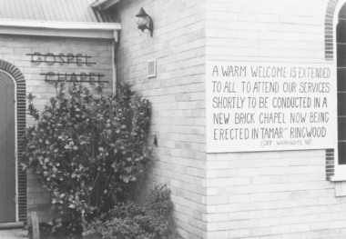 Ringwood and District Historical Society
Photograph, Notice of Upcoming Closure of Ringwood Gospel Chapel in Warrandyte Road, Ringwood - 1974, 1974
Exterior view of Ringwood Gospel Chapel in Warrandyte Road, Ringwood, prior to relocation in 1974.Written on back of photograph, "5.10.74". The board on the Church says, "A warm welcome is extended to all. To attend our services shortly to be conducted in a new brick Chapel ... being erected in Tamar Street, Ringwood (off Warrandyte Road)." -
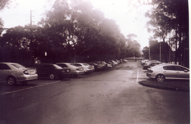 Whitehorse Historical Society Inc.
Photograph, Car Park - rear of Recreation Centre, 1/06/2009
One of a collection of photographs taken of the Nunawading Railway Station prior to the lowering of the railway line and building of the new railway station on the western side of Springvale Road so that the Springvale Road Rail Crossing can be eliminated.Black & white photograph of he precinct surrounding the Nunawading Station and the Springvale Road Railway crossing. This photograph is of the car park on north side of railway line and west side of Springvale Road behind the Recreation Centre. This will be site of new station. See NP 3545 to NP3567 for the complete set of photographsnunawading railway station, springvale road nunawading, redevelopment of railway line/springvale road. -
 Kew Historical Society Inc
Photograph - Yarra Valley Floods: Kew East, 1916
Flooding of the Yarra Valley, including that section of the Yarra bordering Kew and Kew East in the north and west of the municipality, was a regular occurrence. Extreme flood events of the Yarra River are recorded to have occurred in 1891, 1901, 1916, 1923 and 1934. The Municipality of Kew's response to these floods was to enact planning decisions restricting residential development in flood prone areas following the floods of 1916, 1921 and 1934. While floods continued after the development of the Upper Yarra Reservoir (construction 1948-57), the regularity and extent of these inundations diminished. During the nineteenth century, the land abutting the south side of the Yarra in Kew was devoted to dairy farming. In the twentieth century, before and after the construction of the Eastern Freeway, much of this low-lying area was used as golf courses and public parks.One of a collection of photographs of flooding in the Kew section of the Yarra Valley which are in important research resource for the location and extent of flooding in the first half of the twentieth century. Flooding of the Yarra Valley at East Kew in 1916. The view is taken from a street (maybe Birdwood Avenue) intersecting with Kilby Road looking northeast across the flood waters to Ivanhoe and Heidelberg. The extensive flooded area shown in the photograph would have included remnant dairy farms and the Kew Golf Club. Verso: "Floods / Yarra River / East Kew / Kilby Road / 1917? / 87"yarra river, yarra valley, floods -- kew, kilby road -- kew (vic.), kew golf club -
 Eltham District Historical Society Inc
Photograph, George Coop, Single Motor Carriage (Red Rattler) Tait train, possibly 471M, heading for Eltham near Allendale Road, Diamond Creek, c.December 1980, 1980
View is looking northwest from the hillside just north of Allendale Road. The long rectangular house in the upper left is No. 22 Challenger Street, Diamond Creek, right at the sharp turn into Price Court. On the track in the straight section heading northwest are two small bridges where the track crosses the Diamond Creek, each fitted with derailment guard rails to prevent severe derailments should a train come off the tracks whilst crossing the culverts. Digital TIFF file Scan of 35mm Ilford FP4 black and white transparency471m, allendale road, challenger street, derailment guard rail, diamond creek, hurstbridge line, price court, red rattler, red rattler single carriage, single motor carriage, tait train -
 Melton City Libraries
Photograph, Myers Gully, 1935
Mary, Eliza and Ann Dowling arrived in Melbourne in June 1855 on the ship “Hotspur” as assisted immigrants. Mary married in Melton in 1857 to John Luby.The couple lived in Reserve Road Melton. Eliza married in Williamstown 1862 to William Daley a Bootmaker of Ann St, Williamstown. In 1865, Eliza and William lived in High Street Melton. Ann was a domestic servant in Williamstown and married Henri Miers in Melbourne in 1867.They built their house in Melton on the Ballarat road near the intersection of Reserveroad in 1867–Ryans Creek, referred to as Myers GullyMyers Gully at the junction of Reserve Road, now known as Ryans Creeklandscapes of significance, local identities, pioneer families -
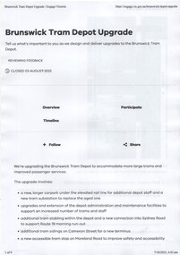 Melbourne Tram Museum
Document, Public Transport Victoria (PTV), Brunswick Tram Depot upgrade, 7-7-2022
Consultation document for the upgrade redevelopment of Brunswick tram depot including the provision of a super stop in Moreland Road. Outlines the proposal and provides a plan. When first published had a tram track extension along Moreland Road, but this was later removed.Yields information about the proposed upgrade of Brunswick Tram depot 2022Five A4 page consultative document, about the upgrade of Brunswick Tram Depot. Only 5 of the 9 pages collected.tramways, brunswick depot, trackwork, sydney road -
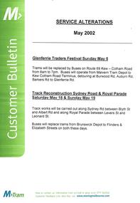 Melbourne Tram Museum
Poster, M>Tram, "Service Alterations May 2002", May. 2002
Poster - A3 size heavy paper, published by M>Tram titled "Service Alterations May 2002" for the Glenferrie Traders Festival Sunday May 5 and Track Reconstruction in Sydney Road and Royal Parade, Sat May 18 and Sunday May 19.trams, tramways, m>tram, services, glenferrie rd, royal parade, sydney rd, trackwork -
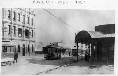 Melbourne Tram Museum
Photograph - Black and White - Moreland Road tram interchange
Well known photograph of the interchange between cable and horse trams at Moreland Road and Sydney Road Brunswick for the Coburg horse tram line. Has two cable tram sets in the background. Coburg horse Tram No. 4, with the now Moreland Hotel in the background. A sign advertising "Patterson & Sons Auctioneers Melbourne" can be seen adjacent to the hotel. Yields information about the tram interchange at Moreland and Sydney Roads Coburg.Black and white photograph - Moreland Road tram interchange with a typed caption "Moreland Hotel 1890".tramways, trams, coburg horse tramway, coburg, horse trams, cable cars, moreland road, sydney road, moreland hotel