Showing 8213 items
matching bridge
-
 Eltham District Historical Society Inc
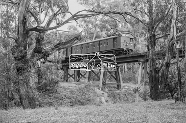
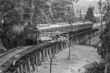
Photograph, George Coop, A Tait (Red Rattler) train bound for Princes Bridge crosses the Eltham Railway Trestle Bridge, c.1981, 1981
Digital TIFF file Scan of 35mm Ilford FP4 black and white transparencyeltham trestle bridge, red rattler, tait train -
 Eltham District Historical Society Inc
Photograph, George Coop, A Tait (Red Rattler) train bound for Princes Bridge crosses the Eltham Railway Trestle Bridge, c.1981, 1981
Digital TIFF file Scan of 35mm Ilford FP4 black and white transparencyeltham trestle bridge, red rattler, tait train -
 Eltham District Historical Society Inc
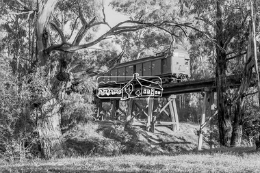
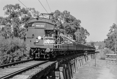
Photograph, George Coop, A Princes Bridge bound Tait (Red Rattler) train approaching the Eltham Railway Trestle Bridge, 7-8 February 1981, 1981
Digital TIFF file Scan of 35mm Ilford FP4 black and white transparencyred rattler, tait train -
 Eltham District Historical Society Inc
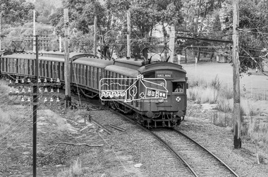
Photograph, George Coop, A Princes Bridge bound Tait (Red Rattler) train crossing the Eltham Railway Trestle Bridge, 7-8 February 1981, 1981
Digital TIFF file Scan of 35mm Ilford FP4 black and white transparencyeltham trestle bridge,red rattler, tait train -
 Eltham District Historical Society Inc
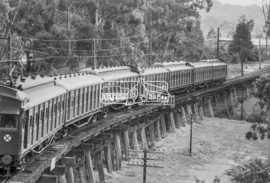
Photograph, George Coop, A Princes Bridge bound Tait (Red Rattler) train crossing the Eltham Railway Trestle Bridge, 7-8 February 1981, 1981
Digital TIFF file Scan of 35mm Ilford FP4 black and white transparencyeltham trestle bridge,red rattler, tait train -
 Eltham District Historical Society Inc
Photograph, George Coop, A Princes Bridge bound Tait (Red Rattler) train crossing the Eltham Railway Trestle Bridge, 7-8 February 1981, 1981
Digital TIFF file Scan of 35mm Ilford FP4 black and white transparencyeltham trestle bridge, hurstbridge line, red rattler, tait train -
 Stawell Historical Society Inc
Archive, Dadswells Bridge Airgraph Letter 1943 to Jean & Bill Howard who was based in London a School Teacher at Ledcourt and Dadswells Bridge and, 1943
Aerogramglenorchy -
 Kew Historical Society Inc
Photograph - Zig-Zag Bridge, 1924
Henry Beater Christian (1886-1962) , was a descendant of one of the earliest settler families in Kew. Employed at the Kew Asylum as a 'public servant', he was a skilled amateur photographer, photographing numerous scenes in Kew and on his travels around Victoria. The majority of his photographs date from 1916 to 1929. His finest photographs are housed in two photograph albums. Digital copy of a photograph from page 8 of the 47-page photograph album containing 261 gelatinous silver images, loaned by Diane Washfold with permission given to digitise and hold a copy in our collection. This photograph reveals how the photographer, Henry Christian, positioned himself to take the photograph from the angle in which he was interested. A skilled canoeist, an empty canoe is on the left of the photo that he apparently he used to access his vantage point. His subject, the Zig-Zag Bridge linked the grounds of the Yarra Bend and Kew Asylums. The wooden bridge was constructed in the 1870s and lasted through numerous floods until its destruction in 1929. A horizontal structure, one climbed steps to reach the higher Yarra Bend bank. At the Studley Park end, the bridge descended via a staircase to reach the much lower bank. "Zig-Zag Bridge"henry beater christian (1886-1962), landscape photography, kew (vic.) — yarra river, christian-washfold collection, photograph albums, zig-zag bridge -
Bendigo Historical Society Inc.
Photograph - ROBERT DENIS KELLY COLLECTION: BRIDGE TO SOUS LE BOIS
Black and white photo: bridge over river, bridge is collapsed in middle. Written on back 'Bridge to Sous Le Bois'.person, robert denis kelly, world war 1, robert denis kelly collection, bridge, france, sous le bois. -
 Kew Historical Society Inc
Photograph - Zig-Zag Bridge on the Yarra River at Kew, 1924
Henry Beater Christian (1886-1962) , was a descendant of one of the earliest settler families in Kew. Employed at the Kew Asylum as a 'public servant', he was a skilled amateur photographer, photographing numerous scenes in Kew and on his travels around Victoria. The majority of his photographs date from 1916 to 1929. His finest photographs are housed in two photograph albums. Digital copy of a photograph from page 8 of the 47-page photograph album containing 261 gelatinous silver images, loaned by Diane Washfold with permission given to digitise and hold a copy in our collection. The Zig-Zag Bridge linked the grounds of the Yarra Bend and Kew Asylums. The wooden bridge was constructed in the 1870s and lasted through numerous floods until its destruction in 1929. A horizontal structure, the walkway was reached via a wooden staircase on the Kew side. The steps were required due to the different levels of the banks on this stretch of the river. "Zig-Zag Bridge"henry beater christian (1886-1962), landscape photography, kew (vic.) — yarra river, christian-washfold collection, photograph albums, zig-zag bridge -
 Warrnambool and District Historical Society Inc.
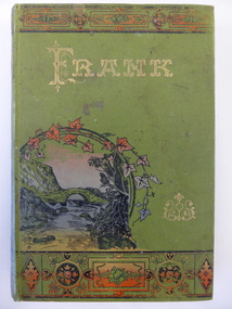
Book, Frank, Late 19th century
This book was given as a prize in 1892 to Joseph Cassady from the Cassady’s Bridge State School. This school, once located near Cassady’s Bridge on the present-day Caramut Road, was opened on 19th January 1891 and closed in December 1892. The first teacher was Janet Ada McDougall and the teacher when the school closed was J. H. Delahenty. The Cassady family had the farm, Boughton and this was established about 1845 on the Merri River near where the bridge is today. Joseph was born in 1882 to William and Elizabeth Cassady.This book is of considerable importance as it is the only memento we have of Cassady’s Bridge State School. This school only existed for two years.This is a hard cover book of 208 pages. The cover is green with coloured borders and a coloured sketch of a stream and a bridge. The lettering on the front cover and the spine is gold and the pages are gilt-edged. The cover is much faded. Some of the back pages are partly torn away. The book has two black and white sketches at the front of the book and 28 chapters of story. The inscription is handwritten in black ink and the inscription page is stained. ‘State School Cassady’s Bridge Xmas 1892 Presented to Joseph Cassady 3rd Class for Good Progress. J.H. Delahenty Head Teacher’ cassady family, boughton, history of warrnambool -
 Clunes Museum
Photograph, CIRCA 1941
BUILDING OF BRIDGE OVER MOUNT CREEK ON ROAD TO MOUNT BECKWORTH, BRIDGE NOW CLOSED TO TRAFFIC.PHOTOCOPY OF PHOTO OF BUILDING BRIDGE OVER MOUNT CREEK TO MOUNT BECKWORTH. CIRCA 1941 TWO MEN IN WORK WEAR STANDING ON BRIDGElocal history, photography, photographs, bridges -
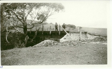
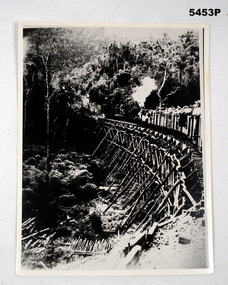
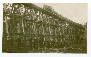 Orbost & District Historical Society
black and white photograph, 1977?
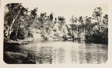
In 1977 great efforts were being made to preserve this bridge, the highest trestle bridge in Victoria at Stoney Creek. The Stony Creek Trestle Bridge was built in 1916 when the existing rail line from Melbourne to Bairnsdale was extended to Orbost. This 97km Bairnsdale to Orbost extension through rugged terrain was reputed to have been the most difficult rail project undertaken in Victoria. In service for over 60 years the bridge was damaged by bushfire in 1980, with the last train crossing in 1987. At 247m long and 20m high, it is the largest standing bridge of its kind in the State, and is listed on the Register of Historic Sites. Built of red ironbark and grey box timber, it is a fine example of the early engineering skills that utilised the resources and materials found on site.The Bairnsdale to Orbost rail line contains the most varied range of timber & timber composite bridges on any Victorian line. The Stoney Creek bridge is listed on the Victorian Heritage Register for its architectural and historical significance.A black / white photograph of a very large trestle bridge. a steam locomotive, with loaded goods trucks, is on the bridge. stoney-creek trestle-bridge railway east-gippsland-railway -
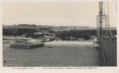 Phillip Island and District Historical Society Inc.
Photograph - Post Card, Early 1900's
Donated by Edith ElmsBlack & White Postcard of view from Suspension Bridge between San Remo and Newhaven. Bridge on right and San Remo Jetty on the left. Houses and farmland of San Remo in background."The Rose Series P. 3460. View from the bridge, looking towards San Remo, Vic."suspension bridge san remo/phillip island, san remo jetty, phillip island, edith elms -
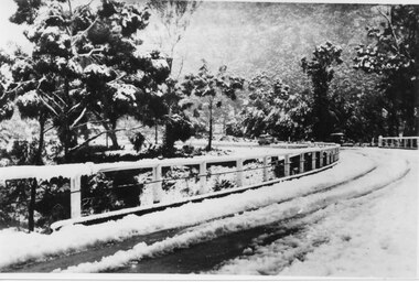 Halls Gap & Grampians Historical Society
Photograph - B/W, C 1940
The third Delley's Bridge, built in 1940 with a curved deck, was situated slightly upstream from the previous bridge. Though it was subject to snow cover from time to time, raging floodwaters were not a threat after Bellfield Dam was built in the 1960s.The picture shows a curving bridge with a wood and wire railing. The bridge and surrounding trees are covered in snow.structures, bridges -
 Kiewa Valley Historical Society
Photographs- 1 old black and white photograph of a wooden bridge over a river possibly Ryders Bridge in Tawonga. 2 –Enlargement of the original photograph showing the gentleman leaning on the bridge. Taken off the original photo
The bridge is not definitively identified, but is of similar construction style to other bridges built in rural areas around this time. Circa 1930”s and may be Ryders Bridge (Old Tawonga Bridge) which crosses the Kiewa River on Mountain Creek Rd Tawonga The first Tawonga bridge was built in 1884- destroyed by floods in 1916. New bridge constructed 1923 and destroyed in 1953. Present concrete bridge constructed in 1986 and named Ryders Bridge These wooden bridges were the only method for transporting stock and produce to market, transporting timber to the mills, sending and receiving mail and for local people to cross the many rivers in the area to go about their daily business. 1- Black and white photograph is glued onto heavy cardboard, which is yellowing with age. Top right hand corner has a tear in the cardboard. Photograph depicts a wooden bridge on wooden piles with 2 white wooden railings along the length of both sides. 2- Original photo has been digitally enlarged to show a gentleman in a light coloured suite and wearing riding boots leaning on the rails of the bridge. The bridge is not definitively identified, but is of similar construction style to other bridges built in rural areas around this time. Circa 1930”s may be Ryders Bridge (Old Tawonga Bridge) which crosses the Kiewa River on Mountain Creek Rd Tawonga bridge; tawonga bridge; kiewa valley -
 Bendigo Military Museum
Photograph - PHOTOGRAPH, STEAM TRAIN, 1942-1945
see. Cat no 5445.2photograph- black and white, curved wooden trestle bridge, on the bridge is a steam loco pulling freight cars with humans sitting atop. The bridge is set in a jungle clad valley, down in The Valley are unused logs and poles. This is a copyRear of photograph- “THAILAND BURMA RLW BRIDGE MADE BY POWS” “ “I believe was between WAMPO and Kin SIA OK” 122309ww2, pow, burma railway -
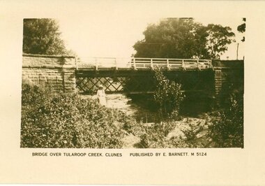 Clunes Museum
Photograph
SEPIA PHOTOGRAPH OF GOVERNMENT BRIDGE OVER TULLAROOP CREEK, CLUNES.BRIDGE OVER TULLAROOP CREEK, CLUNES. PUBLISHED BY E. BARNETT, M5124 [FOR REVERSE - SEE OVER]local history, photography, photographs, bridges -
 Rutherglen Historical Society
Image
Small photograph of the High Street Bridge over the Railway line.On back: "With complements of NG Pearce. B Jasper" "High Street Bridge over Railway Line"high street, railway -
Lakes Entrance Regional Historical Society (operating as Lakes Entrance History Centre & Museum)
Photograph, M Fish, 1970 c
Bridge built 1916 to 1917 demolished after opening of new bridgeColour photograph of concrete bridge over North Arm taken from Eastern side of bridge southern shore of North Arm Lakes Entrance Victoriapolice -
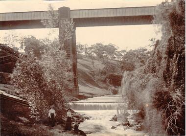 Hume City Civic Collection
Photograph
There are two railway bridges within the Rupertswood grounds. This bridge is over Jackson's Creek near the weir.A photograph of a bridge across a river. There are three women standing in the foreground on the LHS and there is a manmade waterfall in front of the bridge. On the RHS there is a steep sided vine covered drop into the river and there are lightly wooded hills on the LHS of the river. The bridge supports are stone and the span is metal.railway bridge, bridges, jackson's creek, women, waterfalls, rupertswood, sunbury, clothing and dress, george evans collection -
 Kew Historical Society Inc
Photograph - Zig-Zag Bridge, 1924
Henry Beater Christian (1886-1962) , was a descendant of one of the earliest settler families in Kew. Employed at the Kew Asylum as a 'public servant', he was a skilled amateur photographer, photographing numerous scenes in Kew and on his travels around Victoria. The majority of his photographs date from 1916 to 1929. His finest photographs are housed in two photograph albums. Digital copy of a photograph from page 8 of the 47-page photograph album containing 261 gelatinous silver images, loaned by Diane Washfold with permission given to digitise and hold a copy in our collection. The Zig-Zag Bridge linked the grounds of the Yarra Bend and Kew Asylums. The wooden bridge was constructed in the 1870s and lasted through numerous floods until its destruction in 1929. A horizontal structure, the walkway was reached via a wooden staircase. The steps were requires due to the different levels of the banks on this stretch of the river. The photo is taken from the Kew side of the river. "Zig-Zag Bridge"henry beater christian (1886-1962), landscape photography, kew (vic.) — yarra river, christian-washfold collection, photograph albums, zig-zag bridge -
Glenelg Shire Council Cultural Collection
Photograph - Photograph - Bridge Construction, Portland, 1957
Port of Portland Authority ArchivesFront: Back- 'Garden street bridge 1957' - black biroport of portland archives, garden street bridge, construction, workmen -
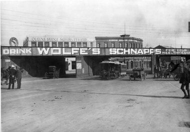 Melbourne Tram Museum
Photograph - Black and White - Cable tram at Queens Bridge South Melbourne
Photograph - undated, possibly prior to the First World War, shows a cable tram with the destination of Spring St passing under the Port Melbourne/St Kilda Rail lines overbridge in Queens Bridge Street. The bridge has a large advert for Wolfe's Schnapps - "for your health sake". On the left-hand side are two policemen talking to each other. There are four horse-drawn carts and one open-top motor car. In the background are Queens Bridge Motors Pty Ltd building and the Queens Bridge Family Hotel. Note the windmill on the left-hand side of the photograph. The railway bridge was partially demolished following the closure of the railway lines in 1987.Yields information about Queens Bridge Melbourne and the rail line over bridge.Black and White Photograph of a cable tram passing under the rail line over bridge at Queens Bridge South Melbourne.trams, tramways, cable trams, queens bridge street, queens bridge motors, queens bridge hotel, wolfe's schnapps, windmills, horse drawn vehicles, railways, port melbourne railway, st kilda railway -
Lakes Entrance Regional Historical Society (operating as Lakes Entrance History Centre & Museum)
Photograph, 1900 c
Black and white photograph of the timber bridge over North Arm showing Club Hotel and guest houses facing front lake Lakes Entrance VictoriaFirst Wooden Bridge over North Armengineering, waterways, islands -
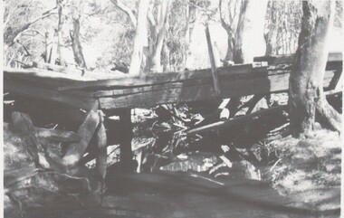 Bendigo Historical Society Inc.
Photograph - HARRY BIGGS COLLECTION: OLD BRIDGE
Photograph (proof 50A) of an old derelict wooden bridge. The bridge is spanning a small creek or possibly a portion of a river, the background is heavily timbered with red gums.bridge, wooden constructyion, derelict bridge, wooden bridge -
 Halls Gap & Grampians Historical Society
Photograph - Coloured, C 1980s
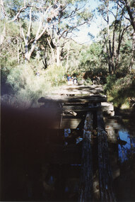
This is a photo of one of the trestle bridges on the Heatherlie Quarry train line. The bridge is located near the current location of "The Pines" campground.The photo is a "front on" of a derelict trestle bridge crossing a shallow creek; many sleepers are missing and thick bush and trees surround the bridge. There are four adults at the end of the bridge, one standing and three seatede. The bottom left hand side of the photo is blurredstructures, bridges, quarrying, heatherlie -
 Eltham District Historical Society Inc
Photograph - Digital Photograph, Alan King, Maroondah Aqueduct Siphon Bridge over the Plenty River, 26 January 2008
Opened in 1891, the bridge formed part of the Maroondah Aqueduct carrying water from Watts River near Healesville to the reservoir at Preston where it joined Melbourne's metropolitan water system. Covered under Heritage Overlay, Nillumbik Planning Scheme. Published: Nillumbik Now and Then / Marguerite Marshall 2008; photographs Alan King with Marguerite Marshall.; p99 Built to supply thirsty Melbourne in the late 19th century, the siphon bridge spanning the Plenty River off Leischa Court, Greensborough, was part of an engineering masterpiece. Opened in 1891, the bridge formed part of the Maroondah Aqueduct carrying water from the Watts River near Healesville to the reservoir at Preston where it joined the metropolitan distribution system. A major link in Melbourne’s water supply, it also had a huge impact on communities, which mushroomed along its route. Named after the Aboriginal word for the area around the Maroondah Reservoir, the Maroondah Aqueduct was fully operational until the 1970s. Since the 1980s the land along parts of the aqueduct have been used for walking and bicycle riding, shaded in places by Monterey Pine trees planted to stabilise the surrounding ground. From 1857 the Yan Yean Reservoir supplied Melbourne’s water but the growing city needed additional catchments.1 In 1886 work began on a weir on the Watts River to enable the aqueduct to carry most of the river water 41 miles (66km) to Melbourne. The aqueduct, built by the Board of Works, is the oldest remaining aqueduct near Melbourne and was probably the first built with concrete.2 Although the aqueduct is now only used between the Maroondah and Sugarloaf Reservoirs, it can still be traced across the Shire. It extends from the Maroondah Reservoir through Christmas Hills, Kangaroo Ground, Research, Eltham, St Helena and then previously wound west through Greensborough to Reservoir.3 Built by horse and manpower the aqueduct gravity fed 25 million gallons (113.6ML) of water a day to Melbourne along a gradient of one foot to the mile. It included 25 miles (41km) of open concrete and brick channel, six miles (10km) of tunnels, and nine miles (15km) of 14 inverted siphons of riveted wrought-iron across creeks. Bricks for the aqueduct were made from clay found near the sites and remains of several kilns can still be found between Kangaroo Ground and Christmas Hills. Building the aqueduct transformed local communities. An abattoir was established at Christmas Hills. Grog shanties and labourers’ camps sprang up and local courts dealt with cases of ‘petty pilfering and boisterous behaviour’.4 The Kangaroo Ground school population jumped to 91, crammed into a room with one teacher. Miners who built the tunnels camped just north of Churinga in Greensborough – then called Tunnel Hill Camp – and adjacent to the Evelyn Arms Hotel. The miners’ high spirits were sometimes quenched in horse troughs or by a ‘welt under the ear and kick on the behind’ as the local constable calmed them down rather than lock them up.5 But the growing city of Melbourne needed more water, so the O’Shannassy catchment, east of Warburton, was added to the system in 1914. In 1920 work began on the present concrete Maroondah Dam one mile (1.6km) from the weir on the Watts River. The aqueduct capacity was thus doubled to 50 million gallons (227ML) a day.6 Intense land development threatened to pollute the open water supply, so channel sections were replaced with large pipes. In the late 1960s a large water main was built from the tunnel outlet at Research and extended through St Helena and Greensborough, so this section of the aqueduct was taken out of use. Long sections of the unused open channels in Greensborough and Bundoora were destroyed, but the old channel in Research and Eltham North remained largely intact. In the 1970s, the Sugarloaf Reservoir was constructed, inundating 445 hectares of land in Christmas Hills. Sugarloaf was officially opened in 1980 and serves as a water storage and treatment plant supplying Melbourne. In the early 1980s pipes replaced the section from Sugarloaf Reservoir to the tunnel entrance at Kangaroo Ground. The Research-Kangaroo Ground tunnel operates as part of the pipeline system.This collection of almost 130 photos about places and people within the Shire of Nillumbik, an urban and rural municipality in Melbourne's north, contributes to an understanding of the history of the Shire. Published in 2008 immediately prior to the Black Saturday bushfires of February 7, 2009, it documents sites that were impacted, and in some cases destroyed by the fires. It includes photographs taken especially for the publication, creating a unique time capsule representing the Shire in the early 21st century. It remains the most recent comprehenesive publication devoted to the Shire's history connecting local residents to the past. nillumbik now and then (marshall-king) collection, maroondah aqueduct, pipe bridge, siphon bridge -
 Lakes Entrance Regional Historical Society (operating as Lakes Entrance History Centre & Museum)
Photograph, 1999
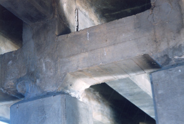
Bridge was built 1917Colour photograph taken underneath the concrete North Arm bridge, shows the original four concrete piers and two piers added to widen bridge. Construction of abutments for new bridge seen in background. Lakes Entrance Victoriabridges, waterways -
 Eltham District Historical Society Inc
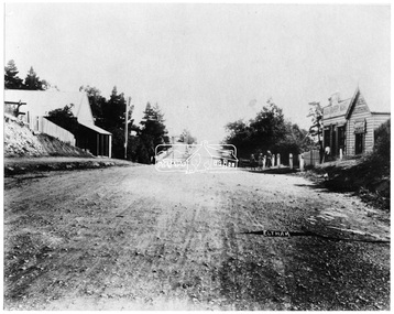
Negative - Photograph, Main Road, Eltham, looking south from Bridge Street, 1906-1907
Looking south along Main Road from the south side of the intersection of Bridge Street with Main Road. Anne Hunniford's Post Office and Burgoyne's store on left. Miss Harriet (Minnie) Williams's Cash Drapery Mart (est. 1902 and enlarged in 1906), also known as Eltham House on the right. Harriet (Minnie) Williams was born London, 1857, the daughter of George John Williams (1812-1895) and Jane Mansfield (1812-1895). In September 1885 she was operating Williams’s Drapery Establishment in premises on Main Road owned by R. Wallis who advertised them to let in September 1885. In 1902 she opened Williams’s Cash Drapery Mart at the southwest corner of Bridge Street and Main Road (opposite the Post Office), owned by W.J. Taylor. In 1906 she bought the premises and one quarter acre of land and expanded the business with a re-opening in April 1906. Harriet was also well-known and esteemed as an active worker in Methodist circles and also Superintendent of the Sunday School. Harriet fell ill in August 1907 and died 15 August. She is buried in Eltham Cemetery with her good friend Ada Ford. Evelyn Observer and Bourke East Record (Vic. : 1902 - 1917), Friday 30 March 1906, page 5 ________________________________________ ELTHAM. (FROM OUR OWN CORRESPONDENT.) For over three years Miss Williams has carried on a drapery business in very small and inconvenient premises opposite the Eltham post-office. Recently she bought the building and a quarter-acre of land from Mr. W. J. Taylor. Thus having a free hand, she at once matured plans to enlarge and improve the premises to make them suitable for her growing business. The result being that she consulted Mr Roach, contractor, of Heidelberg, put the matter in his hands, and now he has completed in a very satisfactory manner and up-to-date style extensive improvements. A large addition, of very neat and attractive design, with three large windows, has been built right along the front of the old building, and the counters and inside fittings are very neat and convenient, harmonizing well with the attractive outside appearance. Miss Williams has now got in a large now stock of goods, and is making extensive arrangements for a “reopening week," commencing 2nd April, during which time she will make 10 per cent reduction on all cash purchases in the form of gifts of that value. Miss Williams has gone to considerable expense and liability both, in the enlargement and improvement of the premises and in purchasing additional stock. We therefore trust that the public will stand by her by heartily and en masse patronizing her re-opening effort to show their appreciation of pluck in this advance movement. Google Street View Feb 2017: https://www.google.com.au/maps/@-37.7191341,145.1462046,3a,50.5y,191.91h,88.27t/data=!3m6!1e1!3m4!1sARwwqEQfMSfH9oTWWapPgQ!2e0!7i13312!8i6656This photo forms part of a collection of photographs gathered by the Shire of Eltham for their centenary project book,"Pioneers and Painters: 100 years of the Shire of Eltham" by Alan Marshall (1971). The collection of over 500 images is held in partnership between Eltham District Historical Society and Yarra Plenty Regional Library (Eltham Library) and is now formally known as the 'The Shire of Eltham Pioneers Photograph Collection.' It is significant in being the first community sourced collection representing the places and people of the Shire's first one hundred years.Digital image 4 x 5 inch B&W Negsepp, shire of eltham pioneers photograph collection, eltham, main road, anne jane hunniford, burgoyne store, christopher watson, commercial bank of australia, drapery store, eltham house, harriet (minnie) williams, post office, watson's hotel, williams's cash drapery mart