Showing 10994 items matching " land"
-
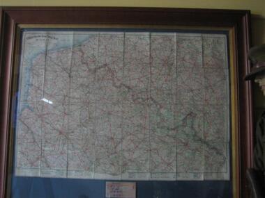
 Melbourne Tram Museum
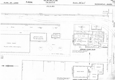
Drawing, Melbourne & Metropolitan Tramways Board (MMTB), "Glenhuntly Depot", c1937
Set of three photocopied plans or drawings on A3 sheet of "Glenhuntly Depot" - c 1938 .1 - P8334 - Plan of land showing details of offices and tennis court - 2-6-1938 .2 - P8335 - Plan of land showing car depot layout and associated buildings - 2-6-1938 - shows substation location. .3 - P8333 - Plan of land showing MMTB land and surrounding properties. - 2-6-1938trams, tramways, drawings, depots, property, glenhuntly tram depot, substation -
 Whitehorse Historical Society Inc.
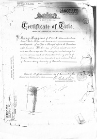
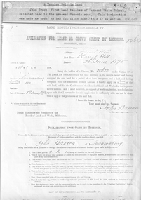
Certificate - Land Title document, Crown Allotment, 5/11/1909
Certificate of Title dated 5/11/1909 covering land in Shady Grove Nunawading purchased by Mary Higgins. Crown Land Allotment No. 116 Parish of Nunawading County of Bourke.land titles, higgins, mary, holmes, dave, shady grove nunawading no.76, helen -
 Phillip Island and District Historical Society Inc.
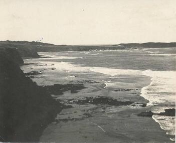
Photograph
Part of a collection donated by Miss Edith Elms via Chrisy NorthcoteCliffs on left with land surrounding Westernport Bay at low tidelocal history, photography, photographs, seascapes, san remo, black & white photograph, westernport -
 Greensborough Historical Society
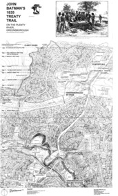
Map, Dennis Ward, John Batman's 1835 Treaty Trail on the Plenty River, 2010_
Map of the Plenty River through Greensborough and surrounding areas, annotated with historic places. Prepared by Dennis Ward, this map shows places of interest with historic markers for a proposed Heritage Trail along the Plenty. This was a joint project of Dennis Ward, Rotary Greensborough and Nillumbik Historical Society.This map shows many places of interest along the Plenty River. Large laminated map, including land subdivisions and street names.plenty river heritage trail -
 Eltham District Historical Society Inc
Folder, Adams, William, 1851
Folder of information on William Adams, land purchaser, Eltham 1851william adams -
Eltham District Historical Society Inc
Folder, James Graham, 1840
Folder of information on James Graham, Land Purchaser, Montmorency, 1840graham james, stuart donaldson -
 Running Rabbits Military Museum operated by the Upwey Belgrave RSL Sub Branch
Map France
Map of France showing position of front line and Nomans Landmaps, ww1, general -
Port Melbourne Historical & Preservation Society
Plan - Land sub-division at 34 Crockford Street, MMBW, Melbourne and Metropolitan Board of Works, Apr 1958
MMBW plan to sub-divide land at 34 Crockford St.built environment - commercial, percival edward mann, sue pentland, mmbw, melbourne and metropolitan board of works -
Port Melbourne Historical & Preservation Society
Book - Borough of Sandridge, accounts book, 1865
Accounts book for blocks of land rates, 1865. Borough of Sandridgelocal government - borough of sandridge -
Port Melbourne Historical & Preservation Society
Photograph - Sketch, Excavation of the Coode Canal and Reclaiming Land, 1880
Photograph of Sketch - Excavation of the Coode Canal And Reclaiming Land. 1880engineering - canals and drainage -
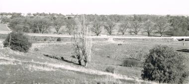 Bendigo Historical Society Inc.
Photograph - 'MARYDALE' AXEDALE COLLECTION: PHOTOGRAPH PANORAMIC VIEW
Photograph.Panoramic view of open land at ''Marydale'', Axedale with road and bridge.axedale, history, marydale property -
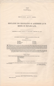 Bendigo Historical Society Inc.
Document - REGULATION FOR REGISTRATION OF AGREEMENTS AS TO MINING ON PRIVATE LAND, 1890
REGULATION FOR REGISTRATION OF AGREEMENTS AS TO MINING ON PRIVATE LAND. 2 copiesVic. Govt.government, state, mines act -
University of Melbourne, Burnley Campus Archives
Document, Student style manual for writing assignments and research reports, 2000
J.C. Avery for Institute of Land & Food Resources (Version 1.2)style manuals, students, assignments, reports, j.c. avery -
Whitehorse Historical Society Inc.
Document, Canterbury Road estate, Unknown
Plan of subdivision of land for sale in Canterbury Road estate, Blackburn.land subdivision, canterbury road estate, blackburn, main street, norvel street, kalka street, arna street, lalwa street, ronley street, eustace street -
Whitehorse Historical Society Inc.
Document, Part of the history of the Lowen's, n.d
Lowen Family bought land on Crown Allotment 100 in 1867.Lowen Family bought land on Crown Allotment 100 in 1867.Lowen Family bought land on Crown Allotment 100 in 1867.lowen family, pioneers -
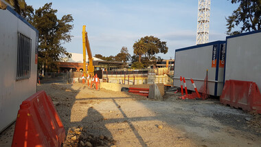 Ballarat Heritage Services
Digital photograph, Lisa Gervasoni, Derby Street Redevelopment, 2017, 2017
Colour photograph of a block of land being redeveloped in Kew, Victoriabuilding, derby street, kew, residential, apratment, construction, redevelopment, overdevelopment -
University of Melbourne, Burnley Campus Archives
Booklet (Item), The University of Melbourne, Burnley College Graduation Ceremony and Presentation of Awards, 1998 - 2004
Some marked Dr. Greg Moore or Dr. Peter Mayburnley college, institute of land and food resources, university of melbourne, greg moore, peter may, graduation ceremony -
Canterbury History Group
Document - List of significant trees, May 2001 - May 2003
Lists of significant trees on public land and private property in Boroondaracanterbury, camberwell, deepdene, balwyn, kew, hawthorn, glen iris, surrey hills, trees -
 Bendigo Historical Society Inc.
Document - H. A. & S. R. WILKINSON COLLECTION: PIECE OF PAPER
Very damaged piece of paper with drawing of a block of land with measurementsorganization, business, h.a. & s.r wilkinson real estate -
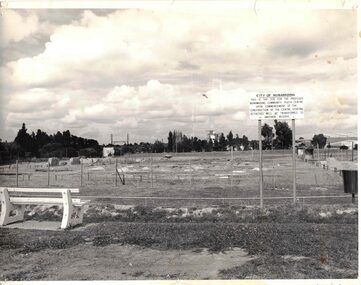 Whitehorse Historical Society Inc.
Photograph - Black & white photograph/s, Nunawading Community Youth Centre
Proposed land for the new Nunawading Community Youth Centre in 1980.nunawading, youth centre, 1980 -
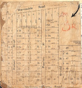 Ringwood and District Historical Society
Map, Residential Subdivision Allotment Layout on Mullum Mullum Road, Hobart Street, Paxton Street, Arnold Street and Warrandyte Road, Ringwood, Vic. circa 1920
One of 3 unrelated land subdivision maps on cardboard backing.H.C. Crouch, Licensed Surveyor, 443 Lt Collins Street, Melbourne. -
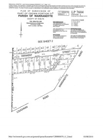 Ringwood and District Historical Society
Document - Subdivision Plan, LP7604 Part of Crown Portion 31B, Parish of Warrandyte, County of Evelyn, Vol 3954 Fol 626 - 2019
A4 LANDATA Land Victoria plan printout dated 2010Map includes Derwent Street and Warrandyte Road, Ringwood. Although marked See Sheet 2, no other page included with collection. -
 Ringwood and District Historical Society
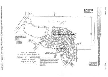
Document - Subdivision Plan, LP83721 - Part of Crown Portion 23, Parish of Warrandyte, County of Evelyn - 1969
A4 LANDATA Land Victoria plan printout dated 2009Two A4 maps of residential subdivision off Wonga Road, Ringwood. Enlargement map includes Holyrood Crescent, Berkley Road, Carmen Court, Frederic Drive, Kenwood Crescent, Marilyn Street and Adele Court. -
 Warrnambool and District Historical Society Inc.
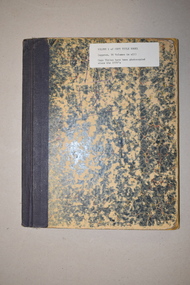
Ledger, Copy Title Book Vol. 1, Late 19th and early 20th centuries
This ledger is Volume One of a series of Copy Title Books that contain certificates of land titles from the Warrnambool district in the late 19th and early 20th centuries. It came from the former premises of the Warrnambool legal firm, Mackay Taylor. This firm originated in the 1890s when George Mackay established a legal practice in Kepler Street, Warrnambool. In 1893 he bought the legal business of James Fletcher, following the death of the latter and the practice became known as Fletcher and Mackay. In 1926 John Taylor became a partner with George Mackay (who died that year) and Mackay, Taylor and Co continued on until 1999 when the firm merged with Tait Solicitors and became Tait Taylor. In 2010 it was renamed Taits Legal. This ledger is of great importance as it contains early certificates of titles of land and property in the Warrnambool district. The information contained therein will be of significant importance to researchers of local history.This is a hard cover book of 200 pages with a mottled green cover and black binding. The index is typed and the contents include certificates of land and property titles and some sketch maps.warrnambool land and property, mackay taylor, history of warrnambool -
 Mt Dandenong & District Historical Society Inc.
Photograph
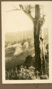
The photograph is from the album of Ivy May Child. It shows a view across the holding of Walter Jeeves. Walter was the second son of Ellis Jeeves and grandson of Isaac Jeeves, the pioneer. Walter was given the house 'Kalorama' and 20 acres of lnd - most of it sloping. He established a commercial garden, initially growing vegetables but later flowers and shrubs. This land now forms part of Kalorama Park. The building in the photograph is the Kalorama Homestead with shrubs and trees planted in rows on the sloping site. Ivy May Child (1910 – 1989) was the daughter of Arthur Edward (Ted) Child (1878 – 1964) and Ethel May Madden (1888 – 1970). Ted Child was the son of Matthew Francis Child (1839 – 1933) and Martha Jeeves (1857 – 1926). He was the grandson of one of the early pioneers Francis Child. Ivy grew up on the family property on Childs Road and took many photographs. Most of these are glued into her photo album. The album covered the years from c1927 – 1932. Ivy married Henry William Burgess (1906 – 1968) in 1944. The photographs remain in their original state in the album with individual copies made. Black and white photograph with a large gum tree in the foreground, a sloping area of cleared, cultivated land and homestead in the centre and a forested area in the distance.An inscription below the photograph in the album reads: W. JEEVESwalter jeeves, jeeves, kalorama homestead, kalorama park -
 Bendigo Historical Society Inc.
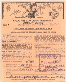
Document - School Accident Policy, 1969
1.CGA insurance became incorporated in NSW in 1920. Iin 1961 it became part of the Zurich Insurance Group. 2. Bendigo Mutual Permanent Land and Building Society first appears in advertising in 1865 and was incorporated in Victoria in 1876. In 1978 it merged with Bendigo and Eaglehawk Star. It eventually became Bendigo Bank.1.CGA Fire and Accident Insurance Company School Accident Policy for Steven Lummis, grade 1, Golden Square High School. 2. Loan Repayment Document with the Bendigo Mutual Permanent Land and Building Society; loan value $11,000.history, bendigo, merle lummis collection, school insurance policy -
Whitehorse Historical Society Inc.
Article, Residents lose in open space planning: claim, 1992
The Urban Land Authority is set to go ahead with the housing development on the former Blackburn South Primary School land.The Urban Land Authority is set to go ahead with the housing development on the former Blackburn South Primary School land. Ms Del Groves objected to the development because of lack of public space.The Urban Land Authority is set to go ahead with the housing development on the former Blackburn South Primary School land.town planning, victoria. urban land authority, blackburn south primary school, no. 4035, groves, del -
 Whitehorse Historical Society Inc.
Report, Boronia Road, 01/06/1875
(a) Application in June 1875 by John Brown, teacher of Vermont School for a lease of land in Boronia Road. (3 pages). (b) Report on the improvements in the land submitted by John Yeoman in November 1875.brown, john, moore, isaac, keenan, yeoman, vermont, land settlement -
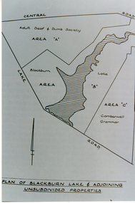 Whitehorse Historical Society Inc.
Photograph, Plan of Blackburn Lake
Black and white photograph of a map of Blackburn Lake showing Adult Deaf & Dumb Society's land and the Camberwell Grammar land on either. Camberwell Grammar was later bought by the former City Of Nunawading.adult deaf & dumb society's flower farm, blackburn lake, camberwell grammar school. -
 Bendigo Historical Society Inc.
Document - H.A. & S.R. WILKINSON COLLECTION: CONTRACT OF SALE
Conditions of sale by public auction dated 25th January, 1930 between A. Mooney (seller) and P.M. McKenzie as agent for Thomas Smith for land situate Allingham Street, Golden Square being land described in certificate of registration as residence area no. 20503, together with all buildings on said land. Price 26 pounds.organization, business, h.a. & s.r wilkinson real estate