Showing 2278 items
matching parish.
-
 Linton and District Historical Society Inc
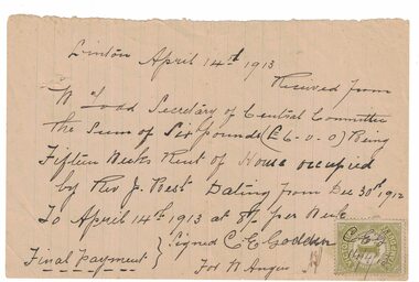
Receipt, Receipt for House Rent, 1913
The Reverend Joseph Best, who was church of England Vicar at Linton between 1912 and 1922, "resided for the first twelve months in a rented house next to the Police Station on the Reservoir Road". In 1912/13 the Church purchased a house to serve as a Vicarage, which was dedicated on 10th April 1913.Handwritten receipt dated 14.4.1913, from C.E. Godden on behalf of W. Angus, to W. Todd, Secretary of Central Committee [of Parish of Linton] for fifteen weeks rent, for house occupied by Rev. J. Best. Victorian Stamp Duty stamp affixed to page, initials "C.E.G." and date "14/4/13" written across it.rev. j. best, w. todd, c. e. godden, receipts -
 University of Melbourne, Burnley Campus Archives
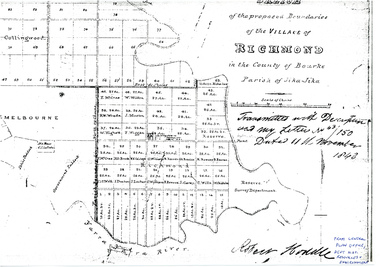
Plan - Photocopy, Sketch of the Proposed Boundaries of the Village of Richmond, 1843
Sketch of the proposed boundaries of the village of Richmond in the County of Bourke Parish of Jika-Jika. Handwritten on original: "Transmitted with Description and my letter No 43/150 Dated 11th November 1843 Robert Hoddle." Shows Burnley Gardens site as "Reserve. Survey Department." original in Central Plan Office, Department of Natural Resources and EnvironmentIn ink: From Central Plan Office Dept. Nat. Resources & Environmentrichmond, jika-jika, survey department, yarra river, robert hoddle -
 Glen Eira Historical Society
Plan - Warrigal Road, Oakleigh
Documents about a small portion of land on Warrigal Road Oakleigh, now Oakleigh East. A Letter dated 29/05/1952 from Gas and Fuel Corporation of Victoria to Mr. L.P. Simmonds requesting valuation of land for proposed widening of Warrigal Road. A plan of Survey, no.5474, for Crown portion of Parish of Moorabbin and Parish of Mordialloc for owner The Brighton Gas Coy Ltd. New Street Brighton. Mortgages to the National Mutual Life Association. A letter dated 04/06/1952 from Gas and Fuel Corporation of Victoria in reference to Warrigal Road and Centre Road from the Country Roads Board who desire to acquire the land. Handwritten calculation notes and price for valuation, most likely as an attachment to the letter dated 04/06/1952.gas and fuel corporation, warrigal road, centre road, moorabbin council, simmonds l.p, survey plan, county of bourke, the brighton gas company ltd., country roads board, the national mutual life association of australia ltd., bentleigh east -
 Greensborough Historical Society
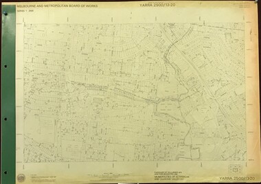
Map, Melbourne and Metropolitan Board of Works. Survey Division, MMBW, Yarra 2500 / 13.20. Greensborough, Montmorency and Watsonia, 1979_03
Melbourne and Metropolitan Board of Works. Yarra 2500 [base map] 13-20. Greensborough, Montmorency and Watsonia. Parishes of Nillumbik 3310 and Keelbundora 2856. Municipalities of Eltham 238 and Diamond Valley 257. Prominent streets include: Nell Street, Nepean Street and Alexandra Street. Includes Montmorency High School.MMBW Map in 1:2500 [scale] series. Cream parchment with green tape reinforcing on edges and punched holes on left edge.mmbw, melbourne and metropolitan board of works, shire of diamond valley, greensborough - maps, montmorency - maps, watsonia - maps -
 Greensborough Historical Society
Map, Melbourne and Metropolitan Board of Works. Survey Division, MMBW, Yarra 2500 / 11.21. Bundoora, east of Plenty Road, 1979_01
Melbourne and Metropolitan Board of Works. Yarra 2500 [base map] 11-21. Bundoora, east of Plenty Road. Parish of Keelbundoora 2856, Municipalities of Diamond Valley 257, Preston 225 and Whittlesea 239. Prominent streets include: Grimshaw Street, Settlement Road and Plenty Road. Includes Yulong Park.MMBW Map in 1:2500 [scale] series. Cream parchment with green tape reinforcing on edges and punched holes on left edge.mmbw, melbourne and metropolitan board of works, shire of diamond valley, bundoora - maps -
 Greensborough Historical Society
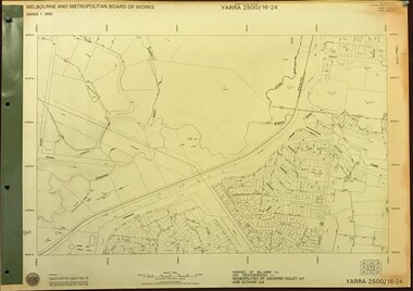
Map, Melbourne and Metropolitan Board of Works. Survey Division, MMBW, Yarra 2500 / 16.24. Northern Diamond Creek and Wattle Glen, 1978_02
Melbourne and Metropolitan Board of Works. Yarra 2500 [base map] 16-24. Northern Diamond Creek and Wattle Glen. Parishes of Nillumbik 3310 and Greensborough 2724. Municipalities of Diamond Valley 257 and Eltham 238. Prominent streets include: Hurstbridge Road, and Reynolds Road. Includes Wattle Glen Station.MMBW Map in 1:2500 [scale] series. Cream parchment with green tape reinforcing on edges and punched holes on left edge.mmbw, melbourne and metropolitan board of works, shire of diamond valley, wattle glen - maps, diamond creek - maps -
 Greensborough Historical Society
Map, Melbourne and Metropolitan Board of Works. Survey Division, MMBW, Yarra 2500 / 13.24. Plenty, Memorial Drive, 1979_03
Melbourne and Metropolitan Board of Works. Yarra 2500 [base map] 13-24. Plenty, Memorial Drive. Parish of Morang 3183. Municipalities of Diamond Valley 257 and Whittlesea 239. Prominent streets include: Oatland Road, River Avenue and Memorial Drive. Includes Plenty River and SEC Transmission easement.MMBW Map in 1:2500 [scale] series. Cream parchment with green tape reinforcing on edges and punched holes on left edge.mmbw, melbourne and metropolitan board of works, shire of diamond valley, plenty - maps -
 Brighton Historical Society
Dress and shoes, 1958
Brighton local Margaret Cooke (nee Parish) had this dress made for the Miss Summer Festival competition fundraiser. The idea for the dress came from a photograph in the Womens' Weekly. A professional dressmaker cut and made the dress. It has an 18" waist. There is a black and white photocopy on file of the dress being worn at the time.Floral cotton dress with matching belt and shoes. Sleeveless polished cotton cream dress with large red, pink and brown rose print. Heavily ruched front. The skirt has an in-built crinoline structure made with thick Vielene lining and corded hoops. Separate belt with bow at centre front. Shoes made to match by 'Suzette' in their original box. .1- dress .2 - belt .3 a-b - pair of shoes .4 a-b - shoe box and lidShoes - Label, printed in gold on white leather in sock: Suzette / Styled in / NEW YORK-PARIS-ST. LOUISprinted fabric, miss summer festival, 1950s, margaret cooke -
 Ringwood and District Historical Society
Map, Proposed Subdivision - Hilltop Estate, Heathmont, Victoria - circa 1925
Plan of Part of Crown Allotments 16 & 18, Parish of Ringwood, County of Mornington. Subdivision includes Site for Heathmont Station, Heathmont Road, George Street, Lilian Street, Edith Street, Edna Street, Great Ryrie Street. Inset locality plan also shows nearby Electric Railway Estate and Heathmont Station Estate. L.H. Webber, Licensed Surveyor, 440 Little Collins Street, Melbourne. -
 Bendigo Historical Society Inc.
Document - TITLE OF LAND AXEDALE
Land title Vol. 3730 Fol. 745810. On the fifth of April Edward Patrick Drake of Axedale hotelkeeper paid 6 pounds for one acre more of less being allotment four of section seven in the town of Axedale, parish of Axedale County. On the other side the names and dates of when the land changed hands up to July 1976.axedale, history, drake family -
 Bendigo Historical Society Inc.
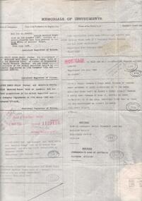
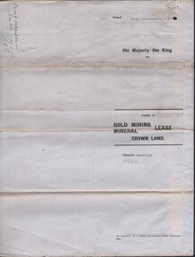
Document - MCCOLL, RANKIN AND STANISTREET COLLECTION: CENTRAL NAPOLEON GOLD MINING CO. N.L, 15th December 1934
Document: Gold Mining Lease Crown Land, No 10260 Bendigo, Entered in the register book vol. 307 fol. 34041, embossed seals of Central Napoleon Gold Mining Co N.L. & King George V, Map: No 10260, Mining district of Bendigo, Parish of Sandhurst, County of Bendigo, During the Reign of King George V.organization, business, industry - mining, mccoll rankin & stanistreet, mining, gold mining, central napoleon -
 Whitehorse Historical Society Inc.
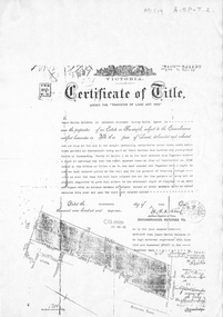
Document, Certificate of Title, 19/07/1918
Photocopy of Certificate of Title Vol. 4156 Folio 831198 for 43 acres Fronting on Canterbury Road near Mitcham Road, being part of Crown Portion 124, Parish of Nunawading, County of Bourke in the name of James Harley Malcolm, 19/7/1918. Last subdivision dated 22/5/1926- current site of Glenburnie Roadland subdivision, malcolm, james harley, mitcham road mitcham, glenburnie road mitcham, canterbury road mitcham, various surnames -
 Bendigo Historical Society Inc.
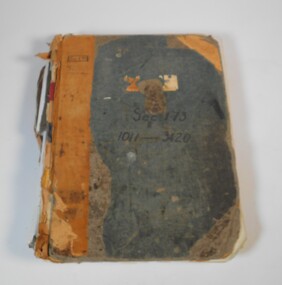
Administrative record - Application for allotments for sale 1908-1974
Green cover book with brown leather spine. The book lists the applications for allotments of land for sale. The headings in the book are: number of application, date of registry, date of application, surname, Christian name and address, parish, allotment, section, area, local land board schedule, classification, crown grant, references and remarks. It covers the years 1908 -1974.Spine has a red label with gold letters. On the cover the remnants of a label, under in ink Sec.173, 1011-3420. At top left of the cover Sec.171 SHland sales, govrnment -
 Bendigo Historical Society Inc.
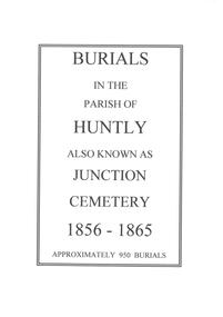
Article - Huntly Burials list
Burials in the Parish of Huntly also known as Junction Cemetary 1856 - 1865. Approximately 950 Burials. Photocopied pages from the original register, stored in thirty-four, A3 plastic pockets. Some photocopied pages have annotations, confirming dates and names. One A4 plastic pocket is at the front holding a title page describing the item.huntly, cemetary, junction cemetary, burial register -
 Bendigo Historical Society Inc.
Document - LANDS OFFICE - SALE OF CROWN LANDS - 1864 - 1869, 1864- 1869
Journal: LANDS OFFICE - SALE OF CROWN LANDS - 1864 - 1869 Brown hard cover journal. Contains details of sales of crown land, listed in chronological order of sales. Includes lot, allotment, section, county, parish, area, upset price per acre, deposit, amount for which sold, valuation, name of purchaser. On spine 011Lands Officelands office, crown land, crown land sales, land sales, bendigo, sandhurst -
 Bacchus Marsh & District Historical Society
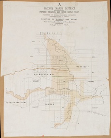
Map, Bacchus Marsh District (A). Proposed Irrigation and Water Supply Trust. Plan shewing boundaries of Trust District
The 1886 Irrigation Act in Victoria introduced the first legislation in Australia designed to enable the creation of a detailed scheme for agricultural irrigation. Part of the legislation saw the use of government funds for local irrigation projects. These local projects were managed by local irrigation trusts. The Bacchus Marsh Irrigation and Water Supply Trust was formed in 1889. This map depicts the proposed area of the Trust.Printed paper map of the proposed Bacchus Marsh Irrigation and Water Supply district. Circa 1889. Plan showing boundaries of Trust District. The District lies within the Parishes of Korkuperrimul, Merrimu, Parwan and Gorrockburkchap in the Counties of Bourke and Grant. At the top of the map above its title is the letter 'A; in capital lettering. Scale: 40 Chains = 1 inch.irrigation, water supply, bacchus marsh irrigation and water supply trust -
 Bendigo Historical Society Inc.
Administrative record - LANDS OFFICE: APPLICATIONS FOR ALLOTMENTS FOR SALE 1869 - 1877, 1869 - 1877
Ledger. Hard cover journal, green cover with dark red spine and corners. Approx. 500 pages. LH page: date, parish, sec. allot. Area, applicant, address, valuation. RH page: owner of improvements, any other improvement on lot, upset price, remarks. On spine - 'applications for allotments for sale' and 'appn's for sale'.Lands Officeplace, land sales, bendigo, sandhurst -
 Bendigo Historical Society Inc.
Document - REGISTRATION OF RESIDENCE AREAS 9433 - 13296: 1899 - 1905, 1899 - 1905
Document: hard cover journal, originally dark cover with burgundy binding on spine. In very poor condition, pages loose. Details: left hand page: date of registration, holder or owner, miners right etc., description of allotment, township or parish, memo, registration. Right hand page: same. Details land registrations in Bendigo and district.bendigo, sandhurst, land sales, residence licences -
Glen Eira Historical Society
Document - St. Mary’s Church, Caulfield
A report on St. Mary’s Anglican Church written in February 1889 by Rev. Macartney. Includes a summary of events from 1853-1888 and information on the contribution to the various churches in the parish. Also includes a listing of contributors to Mrs. Macartney’s memorial window, and tow financial statements related to the building of the church from 1871-1874.caulfield, macartney h.b., parsons c.h., st. mary’s church, sunday schools, st. clement’s church, glen huntly road, st. catherine’s church, camden town, booran road church, memorials, glen eira road -
 Greensborough Historical Society
Map, Melbourne and Metropolitan Board of Works. Survey Division, MMBW, Yarra 2500 / 13.23. Plenty, Happy Hollow, 1979_03
Melbourne and Metropolitan Board of Works. Yarra 2500 [base map] 13-23. Plenty / Happy Hollow. Parishes of Morang 3183, Nillumbik 3310 and Keelbundora 2856. Municipalities of Diamond Valley 257 and Whittlesea 239. Prominent streets include: McLaughlans Lane and Happy Hollow Drive. Includes Janefield Colony Reserve.MMBW Map in 1:2500 [scale] series. Cream parchment with green tape reinforcing on edges and punched holes on left edge.mmbw, melbourne and metropolitan board of works, shire of diamond valley, plenty - maps, happy hollow -
 Greensborough Historical Society
Map, Melbourne and Metropolitan Board of Works. Survey Division, MMBW, Yarra 2500 / 13.23. Plenty, Middle Gorge, 1978_04
Melbourne and Metropolitan Board of Works. Yarra 2500 [base map] 13-23. Plenty / Middle Gorge. Parish of Morang 3183. Municipalities of Diamond Valley 257 and Whittlesea 239. Prominent streets include: Gorge Road, Kurrak Road and Browns Lane. Features include the Plenty River and Plenty Gorge Park.MMBW Map in 1:2500 [scale] series. Cream parchment with green tape reinforcing on edges and punched holes on left edge.mmbw, melbourne and metropolitan board of works, shire of diamond valley, plenty - maps, plenty gorge park -
 Greensborough Historical Society
Certificate of Title, Certificate of Title Vol. 3182 Fol. 302, 15/02/1907
Title in the name of Joseph Laidlay of Greensborough, fruitgrower, 14 acres being Lots 7, 8 and 22 on Plan of subdivision 4759, part of Crown portion 17, Parish of Keelbundora County of Bourke, dated 15th February 1907. Northern boundary Greensborough (now Grimshaw) Road, Eastern boundary Henry Street.1 p. colour copy of Titlegreensborough, grimshaw street greensborough, henry street greensborough, joseph laidlay -
 Uniting Church Archives - Synod of Victoria
Photograph, Peter Moonie, 14/08/1985
Reverend Peter Moonie (10/11/1933 - 08/12/2013) was ordained as a Methodist minister in 1961. He served at on King Island and at Launceston South, in the United States at Salem New Hampshire and Agawam Massachusetts, Church of All Nations, Box Hill Regiobnal Parish and Ocean Grove. He retired in 1995.B & W waist length photograph of Rev. Peter Moonie."Peter Moonie C&N 14/8/1985 page 15"moonie, peter, methodist minister -
 Eltham District Historical Society Inc
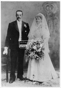
Photograph, Marriage of William George Gray and Frances Ellen Hurst, 12 May 1897
Marriage of William George Gray to Frances Ellen Hurst. They were married at St. Mark's Church, Fitzroy in the Parish of St. Peter's, Eastern Hill, Melbourne, 12 May 1897. Frances was one of three daughters to Francis and Catherine Hurst of Hurstbridge. William and Frances would settle in Hurstbridge and operate Allwood Nurseries. This photo forms part of a collection of photographs gathered by the Shire of Eltham for their centenary project book, "Pioneers and Painters: 100 years of the Shire of Eltham" by Alan Marshall (1971). The collection of over 500 images is held in partnership between Eltham District Historical Society and Yarra Plenty Regional Library (Eltham Library) and is now formally known as 'The Shire of Eltham Pioneers Photograph Collection.' It is significant in being the first community sourced collection representing the places and people of the Shire's first one hundred years.Digital imagesepp, shire of eltham pioneers photograph collection, hurstbridge, frances ellen hurst, william george gray, wedding, marriage -
 Bendigo Historical Society Inc.
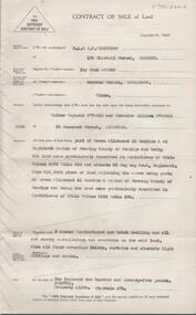
Document - H. A. & S. R. WILKINSON COLLECTION: CONTRACT OF SALE
Contract of sale of land dated 26 March, 1956 between Mrs. I.M. Arthur (vendor) and Mr. W. R. & Mrs. V. L. O'Toole (purchaser). Property: piece of land part of Crown allotment 53 section A at Eaglehawk Parish of Nerring County of Bendigo and being land described in certificate of title volume 4870 folio 850 and situate 65 Peg Leg Road, Eaglehawk. Also all the land adjoining being part of Crown allotment 41 section A Parish of Nerring County of Bendigo land described in certificate f title volume 3198 folio 573, together with 6 room weatherboard and brick dwelling and all sundry outbuildings. Also all floor coverings, blinds, curtains and electric light fittings and shades. Price: 1,275 pounds.organization, business, h.a. & s.r wilkinson real estate -
 Greensborough Historical Society
Map, Melbourne and Metropolitan Board of Works. Survey Division, MMBW, Yarra 2500 / 14.27. Yarrambat, Yan Yean Road, 1978_04
Melbourne and Metropolitan Board of Works. Yarra 2500 [base map] 14.26. Yarrambat, Yan Yean Road. Parishes of Morang 3183 and Greensborough 2724. Municipality of Diamond Valley 257. Prominent streets include: Yan Yean Road, North Oatlands Road and Pioneer Road. Features include Yarrambat War Memorial Reserve.MMBW Map in 1:2500 [scale] series. Cream parchment with green tape reinforcing on edges and punched holes on left edge.mmbw, melbourne and metropolitan board of works, shire of diamond valley, whttlesea, yarrambat - maps -
Glen Eira Historical Society
Letter - Elsternwick
A letter from Jeff Atkinson dated 05/06/1997, relating his research on the name Elsternwick and two photocopied photos of the name, taken in England. Two copied pages from BULMERS 1892 on Elsternwick Township, another page c.1871 and dated maps 1786, with Elsternwick/ Elstronwick in the parish of Danthorpe U.K.atkinson jeff, parkside street, elsternwick, ebden charles hotson, elster, elstronwick, caulfield -
 Uniting Church Archives - Synod of Victoria
Print - Photograph, 1951-1953
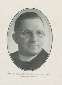
Born 1893. Died 1967. First parish NYAH, 1922 - 1932 at Geelong Yarra St. 1936 - 1959 professor of theology, Queens College. 1959 retired. Rep to WCC 1937 + 1948 and to World Methodist Con 1937. Presiednt Australian Council of Churches, 1952 - 1953. (See Australian Dict. of Biography entry).Oval black and white, oval, head & shoulders studio photographic print portrait of Rev. G. Calvert Barber in clerical dress. He looking to his left. The print is a page that has been removed from a publication."REV. G. CALVERT BARBER, M.A., B.D., PH.D. PRESIDENT-GENERAL"rev g clavert barber methodist minister, president australian council of churches, rev g calvert barber professor of theology queens college university of melbourne, george calvert barber methodist minister, world council of churches, australian council of churches -
 Federation University Historical Collection
Document, Declaration of Ernest by owners of land in Yendon being held as a site for Public Hall and Free Library; 1891, 1891
Document outlining the agreement between five males, all residents of Yendon. Land that had been purchased - being part of Crown Allotment Five Section six, Township of Buninyong East, Parish of Buninyong, County of Grant, has been purchased "as a site for a public hall and free library for the use and benefit of the inhabitants of the Township of Yendon."Thick paper, hand written. Red dots indicate places for signatures Document stamped in green - 0122083 Signatures of; John Winterburn Kemp, Philip Ballantyne, Samuel Henry Mayo, Thomas Dooley, Thomas Watsondeclaration of ernest, land title, free library, public hall, yendon, buninyong, paris of buninyong, county of grant, john winterburn kemp, philip ballantyne, samuel henry mayo, thomas dooley, thomas watson -
 Federation University Historical Collection
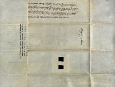
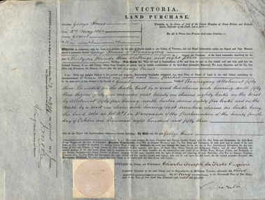
Document, Grant, by Purchase, to George Innes, 3 May 1854, 1854
George Innes purchased land in the County of Grant, Parish of Buninyong, for the sum of Thirty-six pounds, three shillings and eight pence. The price paid was for eleven acres one rood and nine perches. The document is witnessed by Charles Joseph La Trobe Esquire on 3 May 1854 in Melbourne. La Trobe was Lieutenant Governor of the Colony of VictoriaThick paper written on by hand. Top edge and right-hand corner damaged Dated 3 May 1854 Signature of Charles Joseph La Trobe and J Moorela trobe, lieutenant governor, george innes, county of grant, parish of buninyong, land purchase