Showing 179163 items
matching streets
-
 Marysville & District Historical Society
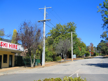
Photograph (Item) - Colour photograph, Travel Victoria, 2004
A colour photograph of the view looking up Pack Road from the corner with Murchison Street in Marysville in Victoria.A colour photograph of the view looking up Pack Road from the corner with Murchison Street in Marysville in Victoria.pack road, murchison street, marysville, victoria, travel victoria, photograph -
 Port Melbourne Historical & Preservation Society
Photograph - Items related to the Davis family, c.1935
Frank, Lil, Nora, Muriel, Mandy & Ted DAVIS lived in Station Street, Port Melbourne in the 1930'3.Digital information on the Davis family of Station Street, Port Melbourne. Includes World War 1 Certificate.frank davis, lil davis, muriel davis, mandy davis, ted davis, station street, nora hopley (davis) -
 Melbourne Legacy
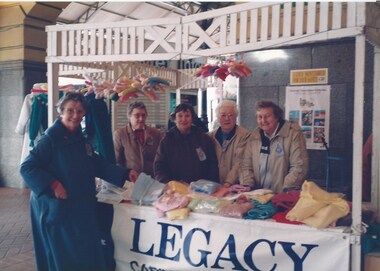
Photograph - Photo, Legacy Appeal, Badge Week Stall, 1990
Two photos of widows with a handcrafts stall at Flinders Street Station in 1990. Widows met regularly at Legacy House for craft gatherings lessons. Some of the items the Widows produced were entered into an annual craft contest and exhibition. Many items were also donated to the annual Badge Week stall that widows organised. The stall was often outside Legacy House but in these photos from 1990 the stall was set up at Flinders Street Station. The ladies names aren't known.A record of the fundraising for the Legacy Appeal in 1990 by the widows clubs.Colour photo x 2 of widows selling items at Flinders Street Station in 1990.legacy appeal, fundraising, badge week, widows, craft -
 Federation University Historical Collection
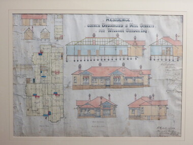
Plan - Architectural Plan, Architectural Drawing of 222 Drummond Street North, Ballarat, 1904, 1904
Perceval Selwyn Richards (ARVIA) was a Ballarat architect who from 1900 to 1940 was responsible for innovative Edwardian and Art Deco style buildings in the district. In 1904 his office was at the Mercantile Building on the corner of Armstrong and Dana Streets, Ballarat. Perceval Selwyn Richards was born 21 July 1865 at Christchurch, New Zealand. He married Alice Emma Nicholson. Percy Richardson sailed to Melbourne, Australia in 1887 to find employment in an architect’s office. On arrival in Ballarat started as an assistant in the architectural firm of William Brazenor, where he worked for six years before continuing with the business after Brazenor's death. He taught Architecture at the Ballarat School of Mines from 1918 to 1921. As well as his work from the Ballarat and District Anglican Diocese and the Ballarat and the Western Districts. Ballarat & Clarendon College is also one of his designs. Framed original architectural by Percival Richards of 222 Drummond Street North, Ballarat, on the corner of Mill Street.perceval richards, percy richards, architecture, ballarat, drummond street noirth, cappell, dobson, w.a. cappell, mary cappell, mary dobson, tom cappell, robert r.g. dobson, alexander edward, cant, n. wellington, william orrack -
 Wodonga & District Historical Society Inc
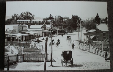
Photograph - Carkeek's Terminus Family Hotel, Wodonga, c1890
The Terminus Hotel, Wodonga was built by James Thompson Hatch in 1873, the same year the railway reached Wodonga from Melbourne. It was named due to its close proximity to the railway terminus. It was sold to Messrs George Day and Kenneth McLennan of Albury. It was first licenced to J.G. Morton in January 1874. Annie Allen, from Ireland, took over as licensee of the hotel containing 14 rooms in 1879, after she and her husband, George James Allen, purchased it. In 1887 they added a new wing on the south boundary of the property next to Peter McLean’s store at 81 Sydney Road. The architects for the new wing were Gordon and Gordon. A billiard room, a dining room, and 18 other rooms were added on the vacant block of land between the Hotel and the Bank of Victoria. A balcony 6 feet wide was added on the north side. Included in the plans was the latest patent elevator, later known as a dumb waiter. Allen died in 1889 aged 52, and Annie Allen continued to run the Terminus. She later married John G. Haldon and was licensee of the hotel until December 1898 when the licence was transferred to William Carkeek. Carkeek, from Cornwall, arrived in the colony around 1860 and is considered one of the founders of Tallangatta. In November 1903, the license was transferred to Daniel Crawford, then in 1906 it was transferred to Mr Stephen Carkeek. In 1916 it passed into the hands of Mr H. W. Allen of Rutherglen, son of Mr George James Allen. On 1st June 1998 the Terminus Hotel was destroyed by fire. Estimates of damage range from between a conservative $750,000 to as high as $2 million. The remains of the building were demolished in 1999.The Terminus Hotel was one of the earliest hotels in Wodonga with clear links to the establishment of the railway line. It was an important business and meeting place for social gatherings.A black and white image printed on canvas. The image includes Carkeek's Terminus Family Hotel in Sydney Road, now named High Street, Wodonga, Victoria. Other businesses shown include a produce store, D.M. Staveley Taylor, John Whan General Store. The railway track can be seen in the foregrounc.Across side of building "CARKEEK'S TERMINUS FAMILY HOTEL" On bottom left "High Street Wodonga 1890s"carkeek, terminus hotel, hotels wodonga -
 Kew Historical Society Inc
Plan, Melbourne & Metropolitan Board of Works : Borough of Kew : Detail Plan No.1565, 1905
The Melbourne and Metropolitan Board of Works (MMBW) plans were produced from the 1890s to the 1950s. They were crucial to the design and development of Melbourne's sewerage and drainage system. The plans, at a scale of 40 feet to 1 inch (1:480), provide a detailed historical record of Melbourne streetscapes and environmental features. Each plan covers one or two street blocks (roughly six streets), showing details of buildings, including garden layouts and ownership boundaries, and features such as laneways, drains, bridges, parks, municipal boundaries and other prominent landmarks as they existed at the time each plan was produced. (Source: State Library of Victoria). This plan forms part of a large group of MMBW plans and maps that was donated to the Society by the Mr Poulter, City Engineer of the City of Kew in 1989. Within this collection, thirty-five hand-coloured plans, backed with linen, are of statewide significance as they include annotations that provide details of construction materials used in buildings in the first decade of the 20th century as well as additional information about land ownership and usage. The copies in the Public Record Office Victoria and the State Library of Victoria are monochrome versions which do not denote building materials so that the maps in this collection are invaluable and unique tools for researchers and heritage consultants. A number of the plans are not held in the collection of the State Library of Victoria so they have the additional attribute of rarity.Original survey plan, issued by the MMBW to a contractor with responsibility for constructing sewers in the area identified on the plan within the Borough of Kew. The plan was at some stage hand-coloured, possibly by the contractor, but more likely by officers working in the Engineering Department of the Borough and later Town, then City of Kew. The hand-coloured sections of buildings on the plan were used to denote masonry or brick constructions (pink), weatherboard constructions (yellow), and public buildings (grey). MMBW Plan No.1565 is an example of a plan where a number of streets have been created since the area was surveyed, or in other cases renamed. The plan shows those streets that were bordered by Ross Street, Mount Street, Sackville Street and Burke Road. Since 1905, Mawson Street has been created and Mont Albert Road renamed as Dean Street. Named houses on the plan include ‘Tyrol’, ‘Glengorse’, ‘Theodore Villa’, ‘Arncliffe’, ‘Ballynira’ and ‘Hazeldene’. The plan also shows a Wesleyan Church in Sackville Street. In 1883, the Church’s Sunday School celebrated its silver anniversary.melbourne and metropolitan board of works, detail plans, mmbw 1565, cartography -
 Mission to Seafarers Victoria
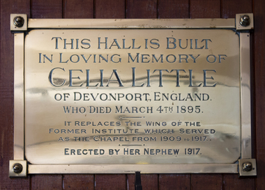
Plaque - Memorial Plaque, P.J. King, Celia Little, 1917
A similar plaque was placed in the chapel of the former Institute to Seamen, Siddeley Street, as indicated on this one. Some money from Miss Little's estate, in England, went to the construction of the new wing of the Siddeley Street Insitute on condition it was used as a chapel until a permanent church was built. We can see the plaque on the top corner of photographs taken in the chapel at that time. Celia Little (1822-1895) was the Reverend Alfred Gurney Goldsmith's aunt. She was the sister of his mother Mary Anne Little (1820-1877) who married Malcolm Goldsmith (1818-1871). Celia didn't marry and lived with her nephew John Philip Goldsmith (1847-1919), Alfred's brother, and his family in Devonport, where she died. Bronze plaque placed on the east wall of the "Celia Little Room" in the Mission to Seafarers, 717 Flinders Street.This hall is built in loving memory of Celia Little of Devonport England / who died March 4th 1895 / It replaces the wing of the former institute which served as the chapel from 1909 to 1917 / Erected by her nephew.celia little, celia little room, plaque, memorial plaque, chapel, siddeley street institute, alfred gurney goldsmith -
 Kew Historical Society Inc
Photograph - Flooding of the Yarra Valley at Kew East, 1974
Flooding of the Yarra Valley, including that section of the Yarra bordering Kew and Kew East in the north and west of the municipality, was a regular occurrence. Extreme flood events of the Yarra River are recorded to have occurred in 1891, 1901, 1916, 1923 and 1934. The Municipality of Kew's response to these floods was to enact planning decisions restricting residential development in flood prone areas following the floods of 1916, 1921 and 1934. While floods continued after the development of the Upper Yarra Reservoir (construction 1948-57), the regularity and extent of these inundations diminished. During the nineteenth century, the land abutting the south side of the Yarra in Kew was devoted to dairy farming. In the twentieth century, before and after the construction of the Eastern Freeway, much of this low-lying area was used as golf courses and public parks.Late example of the capacity of the Yarra Valley at Kew to flood, even though drainage works and the Upper Yarra Reservoir had reduced their regularity.Original black and white print photograph of the low-lying land at East Kew under floodwater on 16 May 1974. The vantage point of the photographer is Lister Street. In the photo, the fences of the Kilby Farm can be seen. Flooding was caused by overflowing water in Glass' Creek and the River Yarra. Annotation verso: "Hay's Paddock op No.30 Lister Street / 16 May 1974 11.50am / R.L. 46.04"hays paddock, floods, yarra river, glass' creek, lister street -
 Surrey Hills Historical Society Collection
Photograph, 11 York Street, Mont Albert, 1974 (2), 1974
This is the home of Ernest Lance Young and Beryl Mair and the childhood home of their children Barbara, Ken and Laurie. Lance was born 24 March 1915 in Surrey Hills, the son of Ernest Augustus Young and Ruby Nichell Whitty. He married Beryl Mair in 1939 and died on 5 October 1999 at Mont Albert. Electoral rolls list him as a manufacturer. His address after marriage was 11 York Street, Mont Albert. He is buried in Box Hill Cemetery (M-*-0867) along with his father. He served in WW2 (Service Number - VX104733 enlisting at St Kilda) and after returning took over his father's business. The Mair family were resident in Barton Street for several generations. Beryl's father Dave Mair was a keen sportsman and founder of the Kangaroo Social Club of cricketers. This is part of a large collection relating to the Mair, Deakin and Young families. Black & white photo of the street view of 11 York Street, Mont Albert. Taken from diagonally across the street, it shows the end of the house, the driveway and the dividing fence between the property and the adjacent house. The house is heavily screened by a mature garden with several large trees or shrubs.In red biro on rear: "No 11 York St / 1974" ken young, barbara young, laurie young, laurie newton, beryl mair, ernest lance young, lance young, york street, mont albert -
 Surrey Hills Historical Society Collection
Photograph, 11 York Street, Mont Albert, May 1974 (2), 1974
This is the home of Ernest Lance Young and Beryl Mair and the childhood home of their children Barbara, Ken and Laurie. Lance was born 24 March 1915 in Surrey Hills, the son of Ernest Augustus Young and Ruby Nichell Whitty. He married Beryl Mair in 1939 and died on 5 October 1999 at Mont Albert. Electoral rolls list him as a manufacturer. His address after marriage was 11 York Street, Mont Albert. He is buried in Box Hill Cemetery (M-*-0867) along with his father. He served in WW2 (Service Number - VX104733 enlisting at St Kilda) and after returning took over his father's business. The Mair family were resident in Barton Street for several generations. Beryl's father Dave Mair was a keen sportsman and founder of the Kangaroo Social Club of cricketers. This is part of a large collection relating to the Mair, Deakin and Young families. Colour photo of the street view of 11 York Street, Mont Albert. Taken from across the street, it shows only part of the gable of the house. The house is heavily screened by a mature garden with several large trees or shrubs. The fence is low and constructed from roughly faced stone.In blue biro on rear: "11 YORK ST / MONT ALBERT" and separately "May 74" ken young, barbara young, laurie young, laurie newton, beryl mair, ernest lance young, lance young, york street, mont albert -
 Tatura Irrigation & Wartime Camps Museum
Photograph, Hogan Street, Tatura
Shows picture of a man walking his dog down Hogan Street, Tatura, near Tatura Milk. Looking west along Hogan Street. Sepia photograph showing man walking a dog near Tatura Milk, Hogan Street, Tatura. Photograph stuck onto piece of white cardboard. tatura victoria, hogan street tatura -
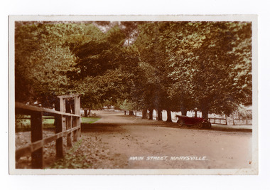 Marysville & District Historical Society
Photograph (item) - Colour tinted photograph, Valentine Publishing Co. Pty. Ltd, No.4. Main Street, Marysville, 1923-1963
An early colour tinted photograph of the main street in Marysville in Victoria.An early colour tinted photograph of the main street in Marysville, Victoria. This street is now known as Murchison Street. This photograph was published by the Valentine Publishing Co Pty. Ltd. as a souvenir of Marysville.marysville, victoria, murchison street, history, valentine publishing co, souvenir -
Whitehorse Historical Society Inc.
Document, My memories of the area around Simpson Park, 1/10/2003 12:00:00 AM
Memories with promptings from Jack Leach who lived in Rupert Street and later in Creek Road.Memories with promptings from Jack Leach who lived in Rupert Street and later in Creek Road. Describes that part of Mitcham south of the railway line between Creek Road and Cochrane street. A sketch map of the area as it was in the 1930's is also supplied.Memories with promptings from Jack Leach who lived in Rupert Street and later in Creek Road.brunswick road, mitcham, creek road, mitcham, cochrane street, mitcham, rupert street, mitcham, bloom family, leach, jack, leach family, simpson family, ferris, ray, simpson park -
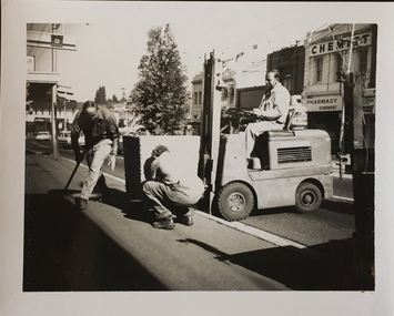 Kew Historical Society Inc
Photograph - Street Beautification: High Street, 1980s
The City Engineer's Department within the former City of Kew, was responsible for public works, including in this instance, street beautification.Kew City Council workers installing planter boxes in High Street, Kew. Junction in distance at left.street beautification, city of kew -- engineers department, public works -- kew (vic.) -
 Eltham District Historical Society Inc
Photograph, Russell Yeoman, 66 Susan Street, Eltham, c.1965, 1965c
... streets ...Bridge Street on left. In 1965 the property was owned by the Shire of Eltham. 66 Susan Street was eventually developed into the Eltham Skate Park in the 1990s and the rest of the property is part of the Alistair Knox Park.Digital file only; created from original colour positive slide transparencyeltham, streets, houses, alistair knox park, eltham skate park, susan street, russell yeoman collection, bridge street -
Port Melbourne Historical & Preservation Society
Container - Bottle, excavated from cesspit at All England Eleven Hotel, 1850s - 1860s
Dug from ground at demolished 282 Rouse Street in 1999 and donated by Peter LIBBISClear glass bottle from group of 1850/1860s bottles dug up at 282 Rouse Street in 1999:domestic life - containers, business and traders - hotels, all england eleven hotel -
Port Melbourne Historical & Preservation Society
Container - Bottle, excavated from cesspit at All England Eleven Hotel, 1850s - 1860s
Dug from ground at demolished 282 Rouse Street in 1999 and donated by Peter LIBBISClear glass bottle from group of 1850/1860s bottles dug up at 282 Rouse Street in 1999:domestic life - containers, business and traders - hotels, all england eleven hotel, t obbinson -
Whitehorse Historical Society Inc.
Document, Plans and Specifications, 1948
House Plans and SpecificationsHouse Plans and Specifications for A.H. Schultz and Sons at 26 Owen Street, Mitcham. Approved 15 Dec 1948.House Plans and Specifications plans, owen street, mitcham, no. 26, schultz, a.h. & sons -
 Marysville & District Historical Society
Photograph (Item) - Colour photograph, Unknown
A colour photograph of Murchison Street in Marysville in Victoria.A colour photograph of Murchison Street in Marysville in Victoria.murchison street, marysville, victoria, photograph -
Port Melbourne Historical & Preservation Society
Clothing - Apron, Port, Pat Grainger, Nov 1987
Made by Pat Grainger for Pickets' street stall"Port" apron made for street stall fund raiser held 1987 by Port Melbourne Pickets, protesters against rail closurepublic action campaigns, pat grainger, amelia finch -
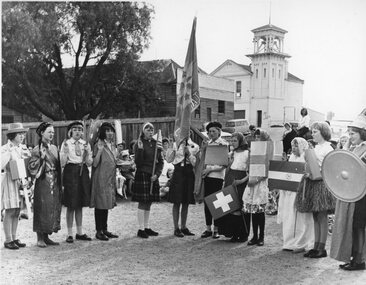 Stawell Historical Society Inc
Photograph, Girl guides in dress up with flag, at guide hall with blacksmith shop and fire station in background
At guide hall on corner of Layzell and Patrick Streets Guides in dress up with flag, at guide hall corner of Layzell and Patrick Street with blacksmith shop and fire station visible in backgroundA Marshall Studios Quality Prints guides -
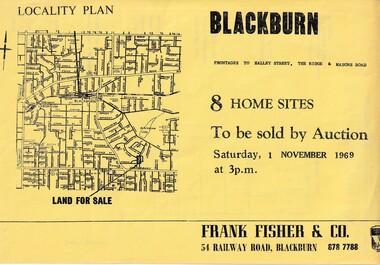 Whitehorse Historical Society Inc.
Document, Blackburn 8 Home Sites, 1/11/1969 12:00:00 AM
Eight home sites to be auctioned by Frank Fisher & Co. on 1 Nov 1969.8 home sites to be auctioned by Frank Fisher & Co. on 1 Nov 1969 with frontages to Halley Street, The Ridge and Masons Road.Eight home sites to be auctioned by Frank Fisher & Co. on 1 Nov 1969. blackburn, frank fisher co., halley street, blackburn, the ridge, blackburn, masons road, blackburn -
 Kew Historical Society Inc
Photograph - Burgess House, Victoria Street (Abbotsford), 1880-1900
Major floods recurred of the Yarra River on a regular basis. A flood in 1901 destroyed this house in Victoria Street, Abbotsford. Later print copy of an original photograph. Home of C/N Burgess on the south side of Yarra River. The buildings were washed away in a flood in 1901 The house was in the same location as that on which Handley & Tilly was later built. This would locate it on the north side of Victoria Street, Abbotsford between Burnley Street and the Victoria Street Bridge. Photo shows three men and one woman working in an established garden in front of a weatherboard cottage."Home of C/N Burgess on south side of river; washed away in 1901; Handley & Tilly on site"yarra river -- floods, yarra river flood -- 1901, burgess family -- victoria street -- abbotsford (vic.) -
 Federation University Historical Collection
Book, Camp Street Precinct Ballarat Conservation Management Plan (Draft), 1999, 10/1999
The conservation management plan was commissioned by the City of Ballarat to assist in the process of planning for the future management and development of the Camp Street precinct, having particular regard for the Camp Street Arts and Education Precinct.White, soft covered, spiral bound book relating to Ballarat's Camp Street Precinct. Contents include: Methodology, buildings and site layout. ballarat, camp street, clare gervasoni, ballarat fine art gallery, art gallery of ballarat, old colonists' hall, former ballarat mining exchange, former state offices, former police court, former police station, former police barracks, old police station, arts academy, archaeology, conservation management plan -
Port Melbourne Historical & Preservation Society
Photograph - Fire at Princes Pier, Port Melbourne, Cameron Oglebury, 15 Aug 1996
Cameron Oglebury of Clark Street was awakened the night the pier burned, went to the end of the street and took this time exposure, which he gave to Ron Laing in October 2000 to be handed to the Society.Colour snapshot of Princes Pier on fire, taken from a distance (Clark Street). Time exposure, a bit blurry. 15 August 1996'Princes Pier Burning taken by Cameron Ogleby' in ink on backpiers and wharves - princes pier, fire and fire services, cameron oglebury -
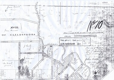 Greensborough Historical Society
Plan, Parish Plan Map of Land North of Grimshaw Street, 11/12/1879
Part of Parish plan of land north of Grimshaw Street bounded by the Plenty River. Includes annotation signed by John Scotland and J. W. Britnell, dated Dec. 11th 1879.Photocopy of part of Parish plan of land north of Grimshaw Street bounded by the Plenty River. Includes annotation signed by John Scotland and J. W. Britnell, dated Dec. 11th 1879greensborough, grimshaw street greensborough, jonah britnell, john scotland -
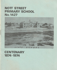 Port Melbourne Historical & Preservation Society
Booklet, Nott Street Primary School No 1427 Centenary 1874 - 1974, 1974
The booklet contains a short history of Nott Street Primary School as well as copies of historic photographs, a list of Head Teachers and pupil reminiscences from the 1920's & 30's. Pale green covered booklet with black & white photograph of Nott Street Primary School.education - primary schools, nott street primary school, celebrations - centenaries -
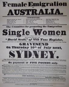 Bendigo Historical Society Inc.
Document - LYDIA CHANCELLOR COLLECTION: HISTORICAL POSTERS
2 large white posters titled, ' FEMALE EMIGRATION to AUSTRALIA.' encouraging single and widowed women ' of good character from 15 to 30 years of age, desirous of bettering their Condition by Emigrating..-' ' Payment of 5 pounds only.' ' ..the splendid teak-built ship' 'David Scott,' of 773 tons register will sail from 'GRAVESEND,' on Thursday 10th of July next…' Printed by Joseph Hartnell, Fleet Street for His Majesty's Stationary Office.' C1834.Printed by Joseph Hartnell, Fleet Street for His Majesty's Stationary Office.' C1834.history, australian, emigration, lydia chancellor, collection, australian history, history, emigration, women, free settlers, early settlement, sydney -
Whitehorse Historical Society Inc.
Letter - Correspondence, Crabhole Hill, 2016
An email from Ted Arrowsmith querying the name Crabhole Hill, Mitcham.An email from Ted Arrowsmith querying the name Crabhole Hill, Mitcham, which encompasses Whitehorse Road from McDowall Street to Thomas Street as reported in the Whitehorse Historical Society Newsletter, series 24 No.3 May - Jun 2016 from a transcript from the Blackburn & Mitcham Reporter 17 Jun 1932.An email from Ted Arrowsmith querying the name Crabhole Hill, Mitcham. crabhole hill, mitcham, arrowsmith, ted, mcdowall street, mitcham, thomas street, mitcham, whitehorse road, mitcham, blackburn & mitcham reporter, whitehorse historical society inc