Showing 3262 items
matching 1911
-
 Wodonga & District Historical Society Inc
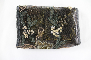
Textile - Hamilton-Smith Collection Beaded Textile c. late 1800s - early 1900s
The Hamilton-Smith collection was donated by the children of Grace Mary Hamilton-Smith nee Ellwood (1911-2004) and John Hamilton-Smith (1909-1984) who settled in Wodonga in the 1940s. The Ellwood family had lived in north-east Victoria since the late 1800s. Grace’s mother, Rosina Ellwood nee Smale, was the first teacher at Baranduda in 1888, and a foundation member of the C.W.A. Rosina and her husband Mark retired to Wodonga in 1934. Grace and John married at St. David’s Church, Albury in 1941. John was a grazier, and actively involved in Agricultural Societies. The collection contains significant items which reflect the local history of Wodonga, including handmade needlework, books, photographs, a wedding dress, maps, and material relating to the world wars. In the nineteenth and early twentieth century prior to the mass production of clothing and textiles, needlework, alongside motherhood, was the defining work of women. Hand sewing and embroidery was central in the everyday lives and domestic roles of women.This item is unique, handmade and has a known owner. It forms part of a significant and representative historical collection which reflects the local history of Wodonga. It contributes to our understanding of social and family life in early twentieth century Wodonga, as well as providing interpretative capacity for themes including local history, social history and women’s history.Bronze and gold embroidery and bead work on black mesh.needlework, beading, sewing, sew, hamilton-smith collection, hamilton-smith, ellwood, handmade, domestic, women, women's history -
 Bendigo Historical Society Inc.
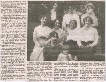
Newspaper - JENNY FOLEY COLLECTION: FAMILY PORTRAIT
Bendigo Advertiser "The way we were" from Thursday, August 12, 2004. Family portrait: on the far right in the back row is Jessie Mueller (born 1892) holding her child Phyllis (born on June 11, 1913. Second from the left in the middle row is Elsie Stewart (nee Squires, born in Ballarat on August 5, 1886, married John Ernest Stewart on March 29, 1911). In the front is Cora Squires (born November 5, 1892) married 23/04/1916 to Melbourne jeweller Stanley White and Marie Stewart (daughter of Elsie and John Stewart, born June 20, 1912 in Bendigo). There is speculation about the remaining people. Back row first on the left: Carrie Stewart (nee Miller) wife of Alexander Stewart. Second from left Jessie Stevenson junior (daughter of Richard Stevenson and Jessie Button born about 1896). Middle row third from left: Jessie Stevenson (nee Button) the wife of Richard Stevenson junior. Far left: unknown. Far right: a Stewart sister (Isabella Melrose or Annie Newton). John Stewart was a prominent stockbroker in Bendigo from 1871 until his death in 1906.newspaper, bendigo advertiser, the way we were -
 Kew Historical Society Inc
Plan, Melbourne & Metropolitan Board of Works : Borough of Kew : Detail Plan No.1570, 1905
The Melbourne and Metropolitan Board of Works (MMBW) plans were produced from the 1890s to the 1950s. They were crucial to the design and development of Melbourne's sewerage and drainage system. The plans, at a scale of 40 feet to 1 inch (1:480), provide a detailed historical record of Melbourne streetscapes and environmental features. Each plan covers one or two street blocks (roughly six streets), showing details of buildings, including garden layouts and ownership boundaries, and features such as laneways, drains, bridges, parks, municipal boundaries and other prominent landmarks as they existed at the time each plan was produced. (Source: State Library of Victoria)This plan forms part of a large group of MMBW plans and maps that was donated to the Society by the Mr Poulter, City Engineer of the City of Kew in 1989. Within this collection, thirty-five hand-coloured plans, backed with linen, are of statewide significance as they include annotations that provide details of construction materials used in buildings in the first decade of the 20th century as well as additional information about land ownership and usage. The copies in the Public Record Office Victoria and the State Library of Victoria are monochrome versions which do not denote building materials so that the maps in this collection are invaluable and unique tools for researchers and heritage consultants. A number of the plans are not held in the collection of the State Library of Victoria so they have the additional attribute of rarity.Original survey plan, issued by the MMBW to a contractor with responsibility for constructing sewers in the area identified on the plan within the Borough of Kew. The plan was at some stage hand-coloured, possibly by the contractor, but more likely by officers working in the Engineering Department of the Borough and later Town, then City of Kew. The hand-coloured sections of buildings on the plan were used to denote masonry or brick constructions (pink), weatherboard constructions (yellow), and public buildings (grey). Plan No.1570 shows the layout of gardens and houses in Sackville Street, Davis Street, Wrixon Street, and Fitzwilliam Street in 1904. While Thomas Street is included on the map, at this stage no houses had been built. The plan identifies two named houses: ‘Fairview’ and ‘Kylemore’. Fairview is more fully delineated in Plan No.1563. Kylemore is one of the few houses in Kew designed by John Beswicke. The most notable owner of Kylemore was William Whitehead, who owned the house between 1895 and 1900. In 1894, Australian newspapers reported the marriage of Whitehead’s daughter to Dr. Gerald Eugene Cussen, the brother of Sir Leo Cussen, the Supreme Court Judge. The married couple was to live at ‘Wilton’ (now the Kew RSL) from 1911-15.melbourne and metropolitan board of works, detail plans, mmbw 1570, cartography -
 The Beechworth Burke Museum
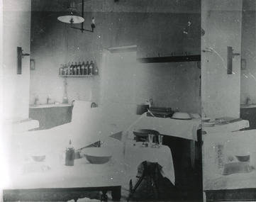
Photograph, c. 1910
Taken approximately 1910, this black and white photograph shows the interior of the surgery and consulting rooms at the Mayday Hills mental hospital known at that time as a lunatic asylum in Beechworth. Mayday Hills Hospital, then known as the Beechworth Lunatic Asylum was constructed between 1864-67 designed by The Public Works Department. The hospital is made up of a number of buildings, landscaping, ha-ha, workshops, laundry, administrative facilities and farmland, it was constructed in 'Italianate' style by a team of up to two hundred and fifty workers (Woods p. 122). The asylum was established in response to the need for the regional shire to locally care for those particularly affected by their time working the Ovens goldfield during the Indigo Shire gold rush era where poor living conditions and isolation were significantly affecting the welfare of a great many people through poverty and lack of resources. The gaol and orphan labour systems were not able to effectively support to give housing, rehabilitation and ongoing care for the mentally ill, and transporting to Melbourne by waggon was a time consuming and counter-productive solution when the metro facilities were already overcrowded. According to Woods (A Titan's Field p. 122), between 1901 and 1911 a large percentage (thirty five percent in 1901 and twenty four in 1911) of the Beechworth population were either patients or inmates of Beechworth institutions, Mayday Hills accounted for some six hundred and seventy four patients in 1901, Beechworth's Mayday Hills was chosen as the site of Victoria's newest asylum, at the time, due to the landscape and altitude. The hilltop atmosphere and the native fauna, it was argued, would assist in the cure of the patients kept at the hospital (Wood 1985, 122). The positioning of the hospital had a beneficial effect on the rural town and the large volume of people living at the hospital and contributing to this population growth is counted as reason for the survival of Beechworth as a regional township. Mayday Hills continued to function as a mental hospital up until 1995 when it was sold to LaTrobe university. The building and grounds are listed on the Victorian Heritage Register under criterion A, B, D, E and F. Although grainy, the image gives a good indication of a functioning interior space of a surgery and consulting room at Mayday Hills in the early 1900's, from which we might interpret (from the types of tools and furniture present), the medical practices being performed at the time.Black and white rectangular photographmedical, asylum, surgery, hospital, beechworth, mayday hills, mayday hills asylum, mayday hills hospital, mental hospital, beechworth lunatic asylum, beechworth institutions, social welfare, public works department, consulting room -
 Puffing Billy Railway
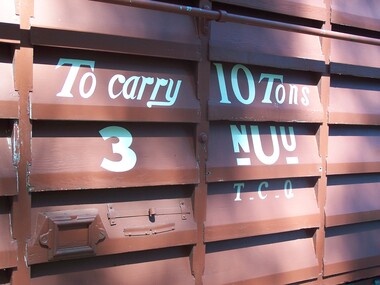
3 NUU - Louvred Truck, 3/12/1900
Van 3 NUU - Louvred Truck (11) VR Service History 3/12/1900 NWS Built new Vehicle Length 25 feet 2 inches ( 7671 mm) Coupled Length 27 feet 4 inches (8330 mm) Width 6 feet 3 inches (1905 mm) Weight 7 tons Capacity 10 tons Built 1898 - 1911 Number Built 14 In use 5 To be restored None *NUU 3.VA - 3/12/1900 NWS Built new - / /1926 - To NU 3.VA - NU 3.VA - circa 1926 - Modified AC Malco 1/10/1977 - Off Register To ETRB Sec76/3630 RS77/4223 NUU The standard louvre van design for the Victorian narrow-gauge lines, the NUU vehicles were constructed in three batches; the first seven from 1899 to 1901, an eighth in 1906 and the last six in 1911, for a total class of fourteen. They looked very similar to the U vans of the Broad Gauge, although two photographs[1][2] of NUU 1 show that its body may have been white for some time. NU In 1926 the class was relettered to simply NU, with no changes to numbers. NU 4 was scrapped in 1938, but otherwise the class remained intact until 1954, when seven members (2, 5, 7, 8, 9, 11 and 12) were sold to Coulston & Hyder, who dispersed the wagons among locations on the Wangarrata to Whitfield line. As of 1996, vans 7 and 12 were at Moyhu, while van 11 was destroyed by fire in 1978. Wagons 6 and 1 were scrapped in 1957 and 1958 respectively, while in 1954 van 13 was recorded as being sold to the Puffing Billy Preservation Society. In 1977, the remaining vans 3, 10 and 14 were handed over to the Emerald Tourist Railway Board, and removed from Victorian Railways records. The Puffing Billy Railway now posesses vans 3, 8, 10, 13 and 14. Historic - Victorian Railways Narrow Gauge - Rolling Stock - Louvered VanWooden Louvered Van - Made of Timber on a Wrought iron frame3 NUUpuffing billy, 3 nuu, louvered van, 2'6" guage, victorian railways, narrow gauge rolling stock -
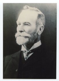 Orbost & District Historical Society
black and white photograph, late 19th / early 20th century
This is a photograph of Councillor Charles Henry Grove who represented South Riding on the Orbost Shire Council. from 1893 - 1901. He was president in 1893-1894, 1895-1896 and 1900-1901. He also served on the Tambo Shire prior to the formation of the Croajingolong / Orbost Shire. Charles Henry [Carl] Grove died on 17/4/1938 at Box Hill at the age of 88 and was buried in Orbost. Prior to coming to the Snowy River district, Carl worked as overseer on Buchan Station. In 1880, he selected land at Newmerella after first coming here in 1874 with early selector James A Robertson. He married Annie Robertson in 1876. Carl was a farmer, hop and seed grower and nurseryman. He was an elected Councillor of the newly formed Tambo Shire in 1882, and then in 1892 to the Orbost Shire where he served for many years filling various public roles. In 1911, he shifted to Queensland, but later returned to Victoria and died at Box Hill. (info. Newsletter 113)This item is associated with the Orbost Shire Council. The shire covered an area of 9,347 square kilometres and existed from 1892 until 1994 when it became part of the East Gippsland Shire Council. It is associated with Carl Grove, a prominent early Orbost citizen.A black / white head and shoulders portrait photograph of a bearded man in a suit. There is also a framed copy.grove-charles-henry grove-carl orbost-shire-council -
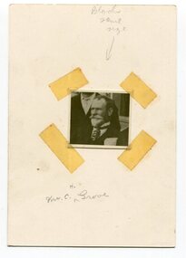 Orbost & District Historical Society
black and white photograph, early 20th century
This is a photograph of Councillor Charles Henry Grove who represented South Riding on the Orbost Shire Council. from 1893 - 1901. He was president in 1893-1894, 1895-1896 and 1900-1901. He also served on the Tambo Shire prior to the formation of the Croajingolong / Orbost Shire. Charles Henry [Carl] Grove died on 17/4/1938 at Box Hill at the age of 88 and was buried in Orbost. Prior to coming to the Snowy River district, Carl worked as overseer on Buchan Station. In 1880, he selected land at Newmerella after first coming here in 1874 with early selector James A Robertson. He married Annie Robertson in 1876. Carl was a farmer, hop and seed grower and nurseryman. He was an elected Councillor of the newly formed Tambo Shire in 1882, and then in 1892 to the Orbost Shire where he served for many years filling various public roles. In 1911, he shifted to Queensland, but later returned to Victoria and died at Box Hill. (info. Newsletter 113Carl Grove was a prominent early Orbost citizen.A small square head and shoulders photograph of a man. It is attached to a white card with tape.on front - "Mr C. Grove"grove-charles -
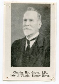 Orbost & District Historical Society
black and white photograph, late 19th century - early 20th century
This is a photograph of Councillor Charles Henry Grove who represented South Riding on the Orbost Shire Council. from 1893 - 1901. He was president in 1893-1894, 1895-1896 and 1900-1901. He also served on the Tambo Shire prior to the formation of the Croajingolong / Orbost Shire. Charles Henry [Carl] Grove died on 17/4/1938 at Box Hill at the age of 88 and was buried in Orbost. Prior to coming to the Snowy River district, Carl worked as overseer on Buchan Station. In 1880, he selected land at Newmerella after first coming here in 1874 with early selector James A Robertson. He married Annie Robertson in 1876. Carl was a farmer, hop and seed grower and nurseryman. He was an elected Councillor of the newly formed Tambo Shire in 1882, and then in 1892 to the Orbost Shire where he served for many years filling various public roles. In 1911, he shifted to Queensland, but later returned to Victoria and died at Box Hill. (info. Newsletter 113)This item is associated with Carl Grove, a prominent early Orbost citizen.A small black / whitee head and shoulders photograph of a man with beard and moustache, He is wearing a suit and tie.grove-charles -
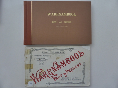 Warrnambool and District Historical Society Inc.
Book, Warrnambool Past and Present x 2, 1907
‘Warrnambool Past and Present’ was written and published in 1907 by Edward Vidler. It is a seminal work on Warrnambool’s history. It is noted for its historical accuracy, its complementary value to Osburne’s History of Warrnambool published in 1887 and its presentation of historically important early photographs. Edward Vidler, born in England, was a writer, historian, journalist, editor and publisher. He was in the Geelong area in the 1880s where he produced a commemorative volume on that city. He was in Warrnambool in the early 1900s where he produced his book ‘Warrnambool Past and Present’ to mark the 60th anniversary of the founding of Warrnambool. He also organized the establishment of the Warrnambool Pioneer Honour Board with the portraits of 204 pioneer men from the area. John Ward was a pioneer settler in the Warrnambool area. He was a Councillor (1880 to 1911) and Mayor and had a shop at the corner of Jamieson Street and Canterbury Road. He was an historian and wrote articles on aspects of early Warrnambool and a comprehensive history of Methodism in Warrnambool. Thomas Wicking was a noted Warrnambool historian in the second half of the 20th century. These two copies are most significant. Originals of this book are rare and the book is of key importance in the recording of Warrnambool’s history. Edward Vidler, John Ward and Thomas Wicking are all of importance in the telling of Warrnambool’s story.These are two copies of the book, ‘Warrnambool Past and Present’. .1 No cover, pages 1-82, (some pages missing at the back), bound with adhesive tape, inscriptions handwritten in black, stamp of Camperdown Historical Society, front and back pages slightly crumpled and torn. .2 Replacement hard cover in brown with gold lettering, pages 1-80, (some pages missing at the back), inscriptions handwritten in pencil and blue ink. Both books contain printed text, many advertisements and over a hundred photographs and illustrations of Warrnambool and district. .1 ‘M.Whitehead’ ‘Presented to the Camperdown Hist. Soc. by Hilda Whitehead, 1988’ .2 ‘Thos. Wicking’ ‘John Ward, 24 Hampton Rd. Armadale’ edward vidler, history of warrnambool, thomas wicking -
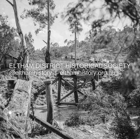 Eltham District Historical Society Inc
Negative - Photograph, J.A. McDonald, Eltham-Diamond Creek Road, 21 Sep 1959
Bridge construction Eltham-Diamond Creek road over the Diamond Creek (Wattletree Road), Eltham, September 1959 After some delay in receiving funds, work started on the bridge approaches in early September 1959. Traffic was still using the old bridge upstream. On Sunday, 20 September 1959, heavy flooding occurred in the stream and at 3:53 pm the old bridge was washed out. This photo was taken the day after. To the left is the Diamond Creek side abutment for the new Wattletree Road bridge under construction. Where the trucks are parked is near the present-day intersection with Progress Road. At the time Progress Road did not exist and was merely a road reserve on the map. The bridge was originally built as a replacement for an older private bridge built by a man named Foley around 1880. In 1911 Heidelberg and Eltham agreed to share the costs to build a new bridge. Construction began in June 1915 and it was officially opened by Cr. Taylor on Cup Day, November 1915.Record of various Shire of Eltham infrastructure works undertaken during the period of 1952-1962 involving bridge and road reconstruction projects, sometimes with Eltham Shire Council Project Reference numbers quoted. It was during this period that a number of significant improvements were made to roads and new bridges constructed within the shire that remain in place as of present day (2022). In many situations, the photos provide a tangible visible record of infrastructure that existed throughout the early days of the Shire. The album was put together by or under the direction of the Shire Engineer, J.A. McDonald.infrastructure, shire of eltham, bridge construction, bridge, diamond creek (creek), eltham, eltham north, glen park bridge, 1959-09-21, flood damage, wattletree road bridge -
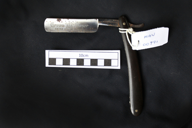 City of Moorabbin Historical Society (Operating the Box Cottage Museum)
Personal Effects, cut-throat razor “Kings Crown’, 20thC
KING RAZOR MFG. CO.Pittsburgh, Pennsylvania; moved to Indiana, Pennsylvania in 1911.ca. 1904 - 1919 Marked "Made in Germany", although the company's offices were located at 118 E. 28th Street, New York City. ca. 1934-1943 Used the "THE KING OF RAZORS REGISTERED TRADEMARK" trademark. 47-1/2 and Trademark: Crown and Wolf. For 500 years the Weyersberg family has been producing the finest blades in the world. For centuries the King’s Crown™ mark has been synonymous with exacting precision, hand-craftsmanship and quality. For the first few hundred years the blades, made in Solingen, Germany (the “City of Blades”), were for swords. As times changed, the Weyersberg family transitioned into making cut throat razors. The Greb. Weyersberg™ family business.continue to place our mark on each and every product sold as we have done since first being able to register it in 1774. For over a 100 years, the straight razors continue to be produced in Solingen (Germany). King's Crown™A folding cut-throat razoron blade ; KING'S / CROWN 'a crown trademark' RAZOR / EXTRA HOLLOW GROUND around 'trademark' ; SET READY FOR USE on steel handle; MADE IN GERMANYcut-throat razors, straight razors, shaving equipment, steel blades, swords, weyersberg family, king crown pty ltd., solingen, germany, early settlers, market gardeners, moorabbin, bentleigh, cheltenham, -
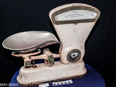 City of Moorabbin Historical Society (Operating the Box Cottage Museum)
Scales, Shop,Imperial, ‘Dayton Scale’, c1900
This 'Dayton Scale' was used in a grocery shop in Moorabbin Shire in 20thC to measure grain, sugar, fruit, vegetables, lollies, etc as required by the shopkeeper for the purchase by customers. The Dayton Scale Company, originally known as the Computing Scale Company, built and marketed the first computing scale in 1891. It was part of the Computing-Tabulating-Recording Company formed in 1911, and became an IBM division in 1933. The Dayton Scale Division was eventually sold to the Hobart Manufacturing Company when IBM decided to stop marketing scales to retail stores. The Computing Scale Company of Dayton was operated from 1891-1914 by two businessmen from Dayton, Ohio who purchased patents on the recently invented computing scale. It was merged with other companies to become the forerunner company for IBM. On July 20 1897 Mr CC Hobart & Herbert L. Johnson formed the Hobart Electrical Manufacturing Company in Troy, Ohio USA. 1915 Hobart continues its growth into the World market, opening a sales office in Australia. Dayton grocery scales, capacity 2 pounds, Imperial Measure. It is made from white painted steel with a large metal scoop that sits on 2 steel rods attached to a balance beam connected to a recording mechanism that displays the ‘weight’ in a glass framed gauge. In window of glass framed gauge ; DAYTON SCALE CO. / OHIO USA ; Computed from 0 – 2LB in 1oz sections weights, measures, shops, scales. balances, grocery stores, early settlers, moorabbin, bentleigh, cheltenham, dayton scales company, ibm pty ltd., hobarrt electrical manufacturing company, hobart c.c., johnson herbert l, computing scale company ohio -
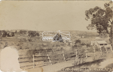 Eltham District Historical Society Inc
Postcard - Photograph, Eltham from Greensborough Road, No. 1, c.1910
The view is looking southeast from near Eltham Road (present-day Sherbourne Road) across Bolton and Bridge streets towards the village of Little Eltham running down the main road (Maria Street) . On the immediate right is Mrs Mary Jane Smart's family home located on the north side of Bridge Street at the intersection with Bolton Street, facing Bolton Street (now part of present day Brisbane Street and occupied by the Kitchen Design Centre). An original early settler's cottage, it was built by Mary Jane Smart's parents, Edwin Bailey and Jane (nee Matthews). Mary Jane Smart was born in the cottage. She married an Englishman, Alexander Wilson Smart who disappeared to Western Australia in the early 1900s in search of gold. He ultimately married again in W.A., committing bigamy and then committed murder and was hung in 1911. Visible at the top left are Watson's (two-storey) Eltham Hotel at the corner of Pitt Street and Maria Street and the Evelyn Hotel directly opposite.Sepia postcardNotations in biro 'A. Petrie', rest in pencil as follows St Margarets N end Shows Wesleyan Church Small Bank Double Storey on Hotel's south end Pearsons house Note roof structure Surface damage to lower left corner1910, bridge street, cba bank, church, clark bros. photo, early settlers, eltham, eltham hotel, evelyn hotel, fountain of friendship hotel, greensborough, mary jane smart (nee bailey), pearson house, pre 1900, road no 1, smart family home, smart home, st margarets, watsons hotel, wesleyan church -
 Orbost & District Historical Society
book, Grove, Carl, BUKAN MUNGEE
C.H. Grove spent about 40 years in the area, information is mainly derived from his own recollections and "reliable sources". Charles Henry [Carl] Grove died on 17/4/1938 at Box Hill at the age of 88 and was buried in Orbost. Prior to coming to the Snowy River district, Carl worked as overseer on Buchan Station. In 1880, he selected land at Newmerella after first coming here in 1874 with early selector James A Robertson.He was one of the first selectors at Orbost - in 1880 he selected 320 acres at Newmerella, which he called „Ulinda‟ He married Annie Robertson in 1876. Carl was a farmer, hop and seed grower and nurseryman. He was an elected Councillor of the newly formed Tambo Shire in 1882, and then in 1892 to the Orbost Shire where he served for many years filling varioius public roles. In 1911, he shifted to Queensland, but later returned to Victoria and died at Box Hill. (Ref. Nov 2014 Newsletter) This is a useful reference tool.A carbon copy of a typeset manuscript / transcript book entitled "Bukan Mungee" containing historical and geographical information of the area "bounded by the Snowy River in the east, the Tambo river in the west...and with the following leaseholds, Ensay, Gillingall, and Gelantipy on the north, with Kilmore and Corringle stations on the south..."grove-carl bukan-mungee corringle newmerella snowy-river tambo-river -
 Glen Eira Historical Society
Document - Dairies
This file contains six items: 1/Handwritten information from 1874 Sands & McDougalls sent to Mr. P Murray in 26/05/1977 from Miss IV Anderson/ 2/Typed pages from Sands & McDougalls, 1911, 1913, 1942 editions dairy entries. 3/Four separate receipts, one photocopied of local dairies, various dates. 4/Two black-and-white photographs of Archibald Short, proprietor of Shorts Dairy in Carlingford Street, and resided in College Street, Elsternwick. 5/Printed document taken from Purchase Agreement between Clara Benzley and Thomas Jenner, on the purchase of a dairy at 43 Woornack Road. Carnegie 13/08/1926. Gives the items included in contract of sale, including 2 horses. 6/Caulfield Glen Eira Leader newspaper article dated is May, 2014, showing upcoming sale of 43 Woornack Road, Carnegie. The property was Clara Benzley’s (granddaughter Claire Barton) dairy in 1926.burlington model dairy, glen huntly road, caulfield, hall mr., carinya dairy, orrong crescent, bradin, rice l. i., dairyman, green r., queens ave., carnegie, neerim road, parton’s dairy, hawthorn road, short archibald, carlingford street, south caulfield, college street, elsternwick, milk cart, dairying, dairies, land sales, real estate, architectural, woornack road, auctions -
 Federation University Historical Collection
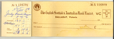
Booklet - English Scottish and Australian Bank Cheque Book, 1950s, English, Scottish & Australian Bank Ltd, c1950
This cheque book was found in a shop on the corner of Sturt and Camp Streets, Ballarat by a builder around 2004. The English, Scottish & Australian Bank Limited was founded in 1852 by Royal Charter in London as the English, Scottish and Australian Chartered Bank. The bank opened its first Australian branch in Sydney in 1853. Australian banknotes were printed by the bank and issued at branches in Sydney, Adelaide, Hobart and Melbourne. In 1893, the bank was renamed the English, Scottish & Australian Bank following the financial upheaval. The bank was one of 16 banks which supplied blank note forms to the Australian Government in 1911 which were superscribed as redeemable in gold and issued as the first Commonwealth notes. The bank took over the Commercial Bank of Tasmania Limited and the London Bank of Australia Limited in 1921 and the Royal Bank of Australia Limited in 1927. On 1 October 1970, the bank merged with the Australia and New Zealand Bank to form the Australia and New Zealand Banking Group Limited. (http://en.wikipedia.org/wiki/English,_Scottish_and_Australian_Bank, accessed 27/03/2014)A half used cheque book from the English, Scottish & Australian Bank Ltd. The used cheques date from 1858 to 1860. Cheques are made out to the Old Colonists Club and Hotel Warrnambool. Notes on the inside cover are precautions against fraud.bank, banking, english scottish and australian bank, anz bank, cheque book -
 Federation University Historical Collection
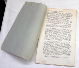
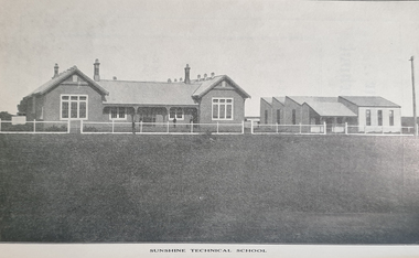
Booklet - Booklet - Prospectus, Exchange Press Pty Ltd, Sunshine Technical School, Prospectus, 1914, 1914
Used at School of mines and industries Ballarat As H.V. McKay's Sunshine Harvester business expanded there was a requirement for a school to train the company's apprentices. In 1911, H.V. McKay wrote to the Victoria Cabinet offering 2,000 pounds and 4 1/2 acres of land in Derby Rd for a technical school, On the 7th July 1913, the new Sunshine Technical School opened with a wooded administration building with six class rooms and a large galvanised iron workshop for the trade apprentices. Mr George Baxter was appointed principal with assistant teachers, A.J. Dunlop (Maths & English), W.W. Anderson (Art) & H.B. Ernest (Maths & Science). Seventy students were enrolled in the first year of which 44 were apprentices from the Harvester Works. During the First World War Years (1914 - 1918) there was a difficulties with staffing and enrollments. The school was also used to provide vocational training for wounded returned soldiers. In 1919 during the great influenza epidemic the school was used as a hospital. Light blue soft covered booklet of 60 pages with information about office bearers, staff, objects of the school, prizes and scholarships, examinations, time tables, courses, and subjects. It has photographs and advertising.sunshine, technical school, sunshine technical school, prospectus, hugh victor mckay, r.m. lambert, george mckay, d.b. ferguson, samuel mckay, george bult, ralph mckay, george butlin, george baxter, f.s. midgley, j.b. gray, w. kerr, a.j. dunlop, h. ernst, w.w. anderson, f. cleary, school councillors, staff, blacksmithing, carpentry, fitting and turning, moulding, sheet metal, mathematis, english, science, art, 1914, h v mckay, sunshine harvester, 2000 pounds and land donated, wounded returned soldiers, 1919 ued as hospital, influenza epidemic -
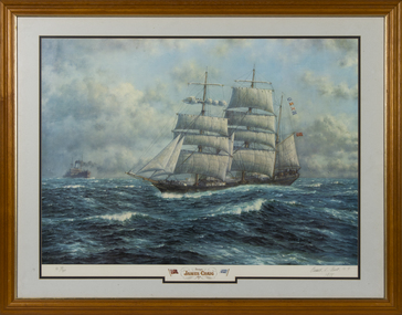 Queenscliffe Maritime Museum
Print - Reproduction print, framed, Oswald L Brett, Barque James Craig 1874, 1974
Built in 1874 in Sunderland England she was employed carrying cargo around the world and rounded Cape Horn 23 times in 26 years. In 1900 she was acquired by Mr J J Craig, renamed James Craig in 1905 and began to operate between New Zealand and Australia until 1911. Unable to compete with freight cargo, in later years James Craig was used as a collier and later laid up, then used as a hulk, until eventually being abandoned at Recherche Bay in Tasmania. In 1932 she was sunk by fishermen who blasted a 3-metre hole in her stern. Restoration of James Craig began in 1972, when volunteers (now the Sydney Heritage Fleet) refloated her and towed her to Hobart for initial repairs. Brought back to Sydney under tow in 1981, her hull was placed on a submersible pontoon to allow work on the hull restoration to proceed. Over twenty-five years, the vessel was restored and relaunched in 1997. In 2001 restoration work was completed and she continues to go to sea.Mr Robeert Greenway A framed reproduction of a painting by Oswald L Brett on canvas paper of the Barque James Craig 1874 Barque James Craig 1874. Images of two flags; a red ensign and a ships flag 'Craig'; Oswald L Brett N.Y. 1978 james craig, windjammers, barque -
 Vision Australia
Photograph - Image, H & L Hecht Trust
Portrait of Hans and Letitia Hecht with a description of the Trust they founded. Between them is a page outlining the work of the Trust they established. The description reads: "H. & L. Hecht Trust. Thanks for Sharing Our Vision. The Association for the Blind thanks the H. & L. Hecht Trust for their generous support of our Western Metropolitan Regional Low Vision Clinic. The trust was established by the late Hans Hecht, an immigrant from Germany who arrived in Australia in 1900. He married Letitia Robinson in 1911. A successful importer and manufacturer, he set up the H. & L. Hecht Trust to give something back to the community for the help he and his wife had received. Hans Hecht died in Melbourne in 1965, aged 84. Letitia died two years later aged 87. Their kindness lives on in the support which their trust has given for the work of the Association for the Blind through their trustees: Mr D W Rogers, Sir Peter Derham, Perpetual Trustees Victoria Limited."2 black and white photographs with central panel of text in grey frame association for the blind, h & l hecht trust -
 Wodonga & District Historical Society Inc
Book - Hamilton-Smith Collection Bible c. 1800s - 1900s, Eyre and Spottiswoode, LTD
The Hamilton-Smith collection was donated by the children of Grace Mary Hamilton-Smith nee Ellwood (1911-2004) and John Hamilton-Smith (1909-1984) who settled in Wodonga in the 1940s. The Ellwood family had lived in north-east Victoria since the late 1800s. Grace’s mother, Rosina Ellwood nee Smale, was the first teacher at Baranduda in 1888, and a foundation member of the C.W.A. Rosina and her husband Mark retired to Wodonga in 1934. Grace and John married at St. David’s Church, Albury in 1941. John was a grazier, and actively involved in Agricultural Societies. The collection contains significant items which reflect the local history of Wodonga, including handmade needlework, books, photographs, a wedding dress, maps, and material relating to the world wars. This Christian bible belonged to Grace Hamilton-Smith (nee Ellwood). The inscriptions indicate it was owned and used while she was at boarding school in Melbourne in the 1930s. It was published by the London printer Eyre and Spottiswood, established in 1739.This item has well documented provenance and a known owner. It forms part of a significant and representative historical collection which reflects the local history of Wodonga. It contributes to our understanding of social and family life in early twentieth century Wodonga, as well as providing interpretative capacity for themes including local history and social history.A black cloth bound Christian bible containing old and new testaments. On inner front page proper left upper corner in pencil: "Grace W Ellwood/"Braeside"/Bethonga./Victoria/Grace Ellwood/Morris Hall/Sth Yarra". On inner front paper proper left lower corner in pencil: "Grace Ellwood/Morris Hall/M.L.L. GLS/1925-6-7".bible, religion, christianity, hamilton-smith, ellwood, wodonga, school, jesus -
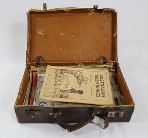 Wodonga & District Historical Society Inc
Booklet - Hamilton-Smith Collection Suitcase with Booklets and other Publications c. early to mid 1900s
The Hamilton-Smith collection was donated by the children of Grace Mary Hamilton-Smith nee Ellwood (1911-2004) and John Hamilton-Smith (1909-1984) who settled in Wodonga in the 1940s. The Ellwood family had lived in north-east Victoria since the late 1800s. Grace’s mother, Rosina Ellwood nee Smale, was the first teacher at Baranduda in 1888, and a foundation member of the C.W.A. Rosina and her husband Mark retired to Wodonga in 1934. Grace and John married at St. David’s Church, Albury in 1941. John was a grazier, and actively involved in Agricultural Societies. The collection contains significant items which reflect the local history of Wodonga, including handmade needlework, books, photographs, a wedding dress, maps, and material relating to the world wars. The ephemeral edition of 'Australian Bush Songs' visible inside the case was published in 1937 in Melbourne by Allan & Co. It contains children's songs drawing on Australian themes which were popular and well-known in the 1930s. This item has well documented provenance and a known owner. It forms part of a significant and representative historical collection which reflects the local history of Wodonga. It contributes to our understanding of social and family life in early twentieth century Wodonga, as well as providing interpretative capacity for themes including local history and social history.A brown vinyl suitcase containing song books, periodicals and magazines c. 1920s - 1930s.hamilton-smith, ellwood, hamilton-smith collection, wodgona, books, reading, songs, song, singing, children, child -
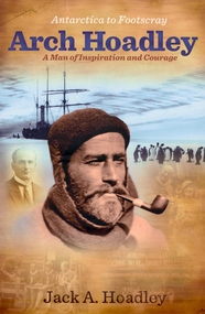 Federation University Historical Collection
Book, Jack A. Hoadley, Antarctica to Footscray: Arch Hoadley, 2010, 2010
Predominantly brown covered paperback of 460 pages featuring an image of Arch Hoadley in Antarctica on the cover.non-fictionballarat school of mines, antarctica, footscray technical school, baden powell, scouts, douglas mawson, arch hoadley -
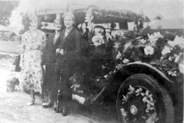 Surrey Hills Historical Society Collection
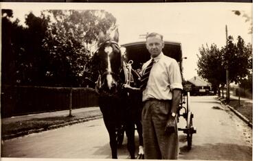
Photograph, Fred Lyons' taxi decorated for celebrations for Empire Day in 1930s, 1933-1938
Lyons family history: From 1907 a cab service operated from near the railway gates in Union Road. It was established and maintained by Mr C Fraser until c1916. George Rea either took over then or set up in opposition. Fred Lyons initially worked for George until he set up his own business. In time he changed over to a motor vehicle and continued his service until 1960. Frederick Adolphus Lyons (1891-1980) was born in Surrey Hills, son of Thomas and Catherine Lyons. He married Elizabeth Ruby Hall in 1918. They lived just around the corner at 55 Sunbury Crescent. The Lyons’ home in Sunbury Crescent was called ‘Knopshambury’ - this was probably a misspelling of Knockshanbally in Co Kilkenny, the birth place of Fred’s father, Thomas Edmund Josias Lyons (1846-1915). Arthur Lyons was born in Surrey Hills on 12 Jun 1920. He became a motor mechanic / welder and lived at 55 Sunbury Crescent. Empire Day celebrations were held in Surrey Hills from 1906-1911 and revitalised from 1933-1938 by the Surrey Hills Progress Association. Street parades featuring decorated business vehicles and bonfires were a feature. This is one of a series of photos donated by Arthur Lyons.The donation was made while he was in hospital. He died shortly afterwards (23 Sep 1990). Donation was finalised by a neighbour, Mrs Florence Ann Armitstead, wife of Glen Victor Armitstead. Glen was a local hairdresser. They moved to 11 Sunbury Crescent after their marriage in 1939. Arthur had no relatives to distribute the material to. Empire Day celebrations were held in Surrey Hills from 1906-1911 and revitalised by the Surrey Hills Progress Association from 1933-1938. The evening parade of floats, and vehicles both horse-drawn and motorised, proceeded along Union Road to the Surrey Gardens beneath festoons of candlelit lanterns, bunting and flags. The paper flowers used extensively on trade and business vehicles were the result of hours of work by families and friends. The Empire Day Celebrations were a great community event, in some years augmented by bonfires, including the ones in Beckett Park.Black and white photo of Fred Lyons' taxi decorated for Empire Day. The cab is parked in the street and is festooned with flowers and ribbons on the hood, bonnet radiator, running board and in the tyre spokes. Three women stand beside the cab. There are houses in the background. motor vehicles, festivals and celebrations, taxis, empire day, fred lyons, frederick adolphus lyons -
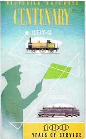 Bendigo Historical Society Inc.
Document - BADHAM COLLECTION: VICTORIAN RAILWAYS CENTENARY 1854-1954 100 YEARS OF SERVICE BOOKLET
Victorian Railways Centenary 1854-1954 100 years of service booklet. Printed in glossy paper, page 1 contains article of 'condensed from a history of the Victorian Railways' which compiled by L.F. Harrigan. The contents include topics of Early private railways (1846-1878), The Melbourne and Hobsons Bay Railway Company - Gala opening, The Victorian government railways four periods of time (during 1856-1864, 1865-1911, 1883-1954, 1950 -1960). Photos inside include the seal of the Melbourne and Hobson's Bay Railway Company, South Yarra station 1874, opening of the Geelong and Melbourne railway June 25 1857, a hotel advertisement of 1857 featuring the Geelong and Melbourne railway - showing 'the British hotel Corio St Geelong, Spencer St station in 1872, the Taradale viaduct, on the Bendigo line in 1864, Harcourt station in 1865, Spirit of Progress, train on the Gembrook line. 1908 steam trains between Flinders St and Richmond the first electric train in Australia on a test run 6.10.1918, moving wheat by train 1901. The aircraft fuselages at Newport workshops during WWII, Bren gun carrier. Newport workshops at Queen Elizabeth Spencer St station 1954. The newsletter published by the Victorian Railways Public Relations and Betterment Board by the direction of the Commissioner.book, magazine, victorian railways, victorian railways / compiled by l.f. harrigan / -the melbourne and hobsons bay railway company - gala opening / south yarra station 1874 / published by the victorian railways public relations and betterment board by the direction of the commissioner -
 Kew Historical Society Inc
Plan, Melbourne & Metropolitan Board of Works : Borough of Kew : Detail Plan No.1296, 1904
The Melbourne and Metropolitan Board of Works (MMBW) plans were produced from the 1890s to the 1950s. They were crucial to the design and development of Melbourne's sewerage and drainage system. The plans, at a scale of 40 feet to 1 inch (1:480), provide a detailed historical record of Melbourne streetscapes and environmental features. Each plan covers one or two street blocks (roughly six streets), showing details of buildings, including garden layouts and ownership boundaries, and features such as laneways, drains, bridges, parks, municipal boundaries and other prominent landmarks as they existed at the time each plan was produced. (Source: State Library of Victoria)This plan forms part of a large group of MMBW plans and maps that was donated to the Society by the Mr Poulter, City Engineer of the City of Kew in 1989. Within this collection, thirty-five hand-coloured plans, backed with linen, are of statewide significance as they include annotations that provide details of construction materials used in buildings in the first decade of the 20th century as well as additional information about land ownership and usage. The copies in the Public Record Office Victoria and the State Library of Victoria are monochrome versions which do not denote building materials so that the maps in this collection are invaluable and unique tools for researchers and heritage consultants. A number of the plans are not held in the collection of the State Library of Victoria so they have the additional attribute of rarity.Original survey plan, issued by the MMBW to a contractor with responsibility for constructing sewers in the area identified on the plan within the Borough of Kew. The plan was at some stage hand-coloured, possibly by the contractor, but more likely by officers working in the Engineering Department of the Borough and later Town, then City of Kew. The hand-coloured sections of buildings on the plan were used to denote masonry or brick constructions (pink), weatherboard constructions (yellow), and public buildings (grey). This area was once known as O’Shaughnessy’s Paddock. O’Shaughnessy was the licensee of the Kew Hotel. The ‘Paddock’ or farm was for many years the closest farm to Melbourne. By 1903, when this plan was surveyed and lithographed, little of the farm remained. The area is dominated by a ‘clay hole’, on the site of the current Foley Reserve. It was used by Smart’s Brickyard from the 1880s until 1911, when the Council purchased it for a rubbish dump. It is notable as the site is one of the few industrial operations to have existed in Kew. By 1903, urban development was characterised by larger houses fronting Barkers Road and brick and weatherboard villas in Foley Street. Nearer the pit, weatherboard houses predominated. Foley Street bisected the triangular block and continued right to Denmark Street. At this stage, a house impeded the through road, only allowing access via a right of way to High Street.melbourne and metropolitan board of works, detail plans, mmbw 1296, cartography -
 Kiewa Valley Historical Society
Book - Non Fiction History, The Kiewa Story, circa 1993
This book provides in chronological order the development of the Kiewa Hydro-electricity scheme from the first concept (1911) to final construction work (1961). It covers the first attempt to utilise the power of the Victorian Alps water system. It started from a private syndicate and developed to the current State Electricity Commission of Victoria. The incentive for the Hydro scheme was to make money and not as an alternative to the carbon producing coal fired power plants. These coal fired power plants were increasing in numbers to service an ever increasing demand made by population expansion, especially in cities and large rural settlements. This demand spiraled up after World War II when there was a tremendous spike in immigration numbers due to refugees and displaced persons in Europe. The ability to utilise the untapped water provided by the winter snow fields, for a higher yield in electricity, was a powerful incentive to overcome the physical hardships in this remote Alpine region. Future power requirements may initiate the re-installation of the other two power stations(Pretty Valley and Big Hill) covered in original Scheme. This publication not only covers the development of the Kiewa Valley region with respect to population (within a socio-economical framework) but also the subtle but yet strong physical changes of a relatively pristine alpine region. The demands that an ever growing regional population places on the environment is clearly documented in print and black and white photographs. The working and living conditions of those who constructed and gave life to this hydro scheme is well documented in this book. It may be viewed as spartan now but was relevantly good at that moment in time, especially for those workers fleeing a devastated European environment. The successful planning and consideration to minimising any intrusion upon the natural alpine forests and high plains can viewed as an example (compared to the Tasmanian Hydro schemes) of how future hydro schemes (an inevitable requirement) will proceed. Most rural towns (in the early 1900s) were built by unencumbered rural based citizens, with the exception of Mount Beauty and Falls Creek. These two settlements were brought into life by a State (Victorian) Authority for a specific function and program. They were a gated community, that is, only open to construction workers involved with the hydro scheme. All facilities within these communities were provided by the State Electricity Commission of Victoria. The impact on the social, financial and individual independency of the community, by the transition from the S.E.C .environment to one of local government (Shire of Bright), had in some cases a severe impact.This hard covered book has a green cover with pictures on the front and back covers. The front cover has a coloured picture of a snow covered Mount Bogong taken from the opposite mountain range. The valley between both ranges has a whisk of mist over it. At the bottom of this picture are three black and white photographs covering the construction of the Kiewa Hydro - Electricity Scheme. On the back cover is a photograph, (black and white) detailing the Bogong village and Junction dam containing lake Guy. The inside front cover is a black and white photograph which details the construction of the West Kiewa tailrace tunnel during April 1951. The inside back cover is a black and white photograph of the concrete pour at the Clover Dam circa 1952. All photographs and sketches are in black and white. The pages are approximately 160 g/m2 and those which have photographs are on gloss paper.Book spine: "The Kiewa Story Graham Napier Geoff Easdown" alongside this is a white framed circle with white spokes radiating out and underneath in white lettering SECkiewa valley, hydro scheme, victorian alpine region, electricity generators, graham napier, geoff easdown -
 Flagstaff Hill Maritime Museum and Village
Container - Tin, Fred Walker Cresco Foods, 1910
Fred Walker 1884 – 1935 was an Australian businessman and founder of Fred Walker & Co. first in Hong Kong, then in Melbourne as the Fred Walker Company. He also set up Kraft Walker Cheese Co. in partnership with American businessman James L. Kraft in 1926, to market Kraft's patented method of processing cheese in Australia. Fred Walker & Co. is best known for creating Vegemite, a yeast extract-based food spread and Australian cultural icon. Kraft Walker Cheese Co. Is best known for manufacturing a cheese known as Red Coon around 1931, which later became known as Coon cheese. He founded the Fred Walker Company at 54 William Street and later moving to Flinders Street in 1911. This company specialised in canned foods, especially dairy products, exporting them to Asia. It manufactured Red Feather canned foods including butter and cheese from around 1910. He also went on to created Cresco Food Co. for his younger brother, which was the first factory to manufacture "flaked food" or dehydrated food products in Australia.A significant item that catalogues the start of dehydrated food production and sale in Australia was initiated by an Australian businessman and well-known entrepreneur. The history of Fred Walker gives insight into how many food brands in Australia now that we take for granted had his involvement in their early beginnings. Large cylindrical tin with push on lid, painted label on the sides in maroon, black gold and dark fawn colours with text.Palm Flaked Rice manufactured by the Cresco Co. Limited Melbourne Australiaflagstaff hill, warrnambool, shipwrecked coast, flagstaff hill maritime museum, flagstaff hill maritime village, great ocean road, container, food container, kitchen ware, flaked rice, cresco, palm flaked rice, tin, fred walker, dehydrated food -
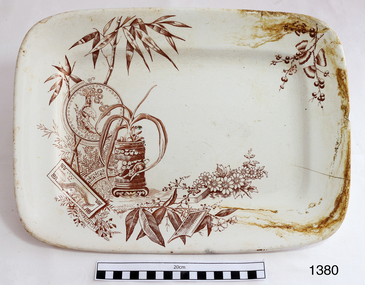 Flagstaff Hill Maritime Museum and Village
Dish
The maker’s initials on the back of the patter, “A.F. & S.” are one of the marks of Alfred Fenton & Sons (& Co) of Brook Street Works (renamed Century Street in 1950’s), Hanley, Staffordshire, Stoke-on-Trent in the United Kingdom. The partners were Alfred Fenton, James Tunstall Fenton, Arthur Fenton and John Fenton. Other initials used are “A F & Co.” The company operated from 1887 to 1901. According to the London Gazette of January 10, 1899, the Earthenware Manufacturers “Alfred Fenton & Sons“ also had a location in Australia at the corner of Elizabeth Street and 314-316 Bourke Street Melbourne Victoria, and Bond Street, Sydney, and in New Zealand at Manse Street, Dunedin. The maker’s mark also includes the word ‘PRAHRAN’, which is an inner suburb of Melbourne. “Prahran” may have been the name of this particular pattern or even the location chosen in preference to the location ‘Melbourne’. The Melbourne address was purchased from a long established drapery business, Wright and Neil, between 1911-1914 by Sidney Myer. Myer constructed his 1914 building in on this site in Bourke Street. This platter is an example of late 19th or early 20th century dinnerware.Dish; white ceramic rectangular platter with picture in brown ink depicting vegetation (including bamboo and blossoms), flower pot, plates and two oriental persons. Made by Alfred Fenton and Sons 1887-1901.Stamped on back, "PRAHRAN / A.F. & S." surrounded by a buckled belt. Number "14" printed in the clay. flagstaff hill, warrnambool, shipwrecked-coast, flagstaff-hill, flagstaff-hill-maritime-museum, maritime-museum, shipwreck-coast, flagstaff-hill-maritime-village, dish, food perparation, dinnerware, catering, a.f. & s., a fenton and son potters of hanley uk, bourke street melbourne, prahran dinnerwear -
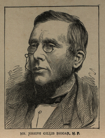 Ballarat and District Irish Association
Image, Joseph Gilles Biggar, M.P., c1864
Joseph Gillies Biggar was a Belfast pork merchant. The Protestant faith has given more leaders to the Irish rebels than the Catholic faith, such as Grattan, Davies, Butt, Mitchell, Parnell, Shaw, Biggar, etc., and all, without exception, were Protestants.(http://www.marxists.org/archive/connolly/1911/connwalk/2-rebirel.htm) "Looking through the long list of those who were present at the Home Rule Conference, one may see the names of men, young or obscure, who were to achieve fame in the movement, and, in some cases, to exercise a decisive influence on its development. The earliest that springs to the eye is " Joseph Gillies Biggar." It was the first time that that misshapened form, with its homely face, its broad smile, its shrewd and fearless glance, was seen ; and the rasping voice, and odd and jerky mode of speaking, was heard, at a nationalist gathering. Biggar was then forty-six, a Presbyterian, head of a successful firm of provision merchants in Belfast, a member of the Municipal Corporation of Belfast, and chairman of the Water Commissioners; and was to commence soon his extraordinary career in the House of Commons. (http://archive.org/stream/homerulemovement00macduoft/homerulemovement00macduoft_djvu.txt) Portrait of a man wearing a glasses. He is Joseph Gilles Biggarballarat irish, biggar, joseph biggar, joseph gillies biggar, pork, belfast -
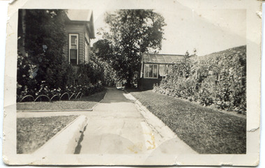 Surrey Hills Historical Society Collection
Digital photo, 45 Wandsworth Road, Surrey Hills, 1956
According to the donor, the photo was taken before the driveway was constructed. The house was later extended at the rear and was re-roofed. The donor's grandparents Daniel Patrick Liddy and Beatrice Bridget Tyner (known as 'Beat') were married in at her parents' home in Glencoe, South Australia on 13 December 1908. They lived in the Carlton / North Melbourne area before moving to Surrey Hills. Electoral rolls list them at 92 Curtain Street, North Carlton in 1913. According to the donor, they rented several properties before purchasing 45 Wandsworth Road. They are listed at Albert Crescent in 1914 and 1919, but also lived in Zetland Road. They purchased 45 Wandsworth Road in c1923 and are listed in the electoral rolls there in 1924. The donor's mother Ellen Dorothy Liddy (known as Eileen) was born in 1909; her brother Daniel John Liddy was born in 1911, both in Carlton. Daniel Patrick Liddy died in 1955; his wife Beatrice died in 1959. They are buried in Box Hill Cemetery (RC183-0045). 45 Wandsworth Road was their home for over 30 years.This image is material evidence of a property that has been demolished.A black and white photo taken from the street looking up a path or narrow driveway. On the LHS is part of a weatherboard house, Edwardian in style. On the RHS is the boundary fence against which is a garden border separated from the driveway by a section of grass. In the background is a glasshouse.Rear along top edge in blue biro: "Aunty Eileens house / before she was married" - according to the donor, this is his cousin's writing. Aunty Eileen was Ellen Dorothy Liddy who married Hugh Turnbull in 1936. Along LH edge, perhaps in a different hand " 23-10-1956" Photo laboratory processing stamp in black ink " 2 48", stamped twice.wandsworth road, daniel patrick liddy, beatrice bridget tyner, beatrice bridget liddy, ellen dorothy liddy, daniel john liddy, box hill cemetery, gardens