Showing 18645 items
matching 1955-6
-
 Eltham District Historical Society Inc
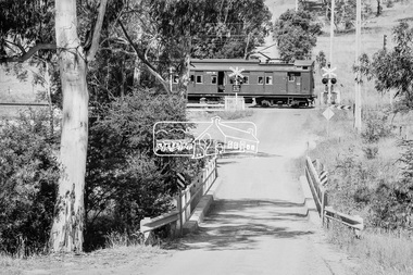
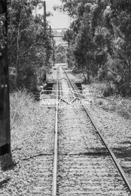
Photograph, George Coop, Single Motor Carriage 471M Tait (Red Rattler) train crossing Allendale Road, heading to Eltham station, 6 December 1980, 1980
The single carriage Tait regularly ran between Eltham and Hurstbridge stations. Looking east along Allendale Road, Eltham to the railway level crossing. The tree on the left remains today (2019) https://goo.gl/maps/zngEcUA29tEWFzuj7Digital TIFF file Scan of 35mm Ilford FP4 black and white transparency471m, allendale road, eltham, hurstbridge line, railway level crossing, red rattler, single motor carriage, tait train -
 Eltham District Historical Society Inc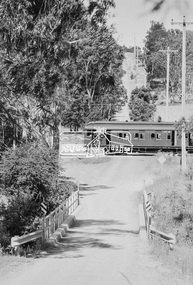
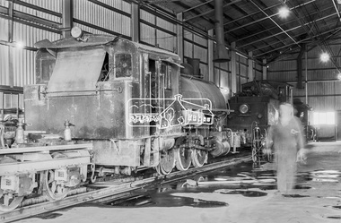
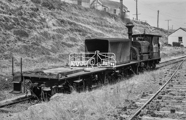
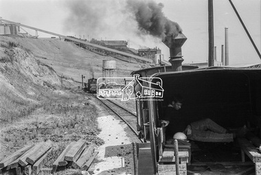
Photograph, George Coop, No. 4 locomotive, a Vulcan Iron Works 0-6-0SToc in the workshop, Fyansford Cement Works Railway, c.Feb. 1964
Narrow gauge private railwayDigital TIFF file Scan of 35mm Ilford FP3 black and white transparencyfyansford cement works railway, george coop collection, vulcan iron works 0-6-0stoc locomotive, geelong -
 Eltham District Historical Society Inc
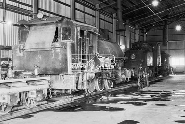
Photograph, George Coop, No. 4 locomotive, a Vulcan Iron Works 0-6-0SToc in the workshop, Fyansford Cement Works Railway, c.Feb. 1964
Narrow gauge private railwayDigital TIFF file Scan of 35mm Ilford FP3 black and white transparencyfyansford cement works railway, george coop collection, vulcan iron works 0-6-0stoc locomotive -
 Eltham District Historical Society Inc
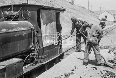
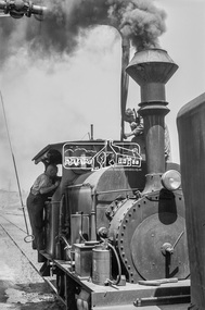
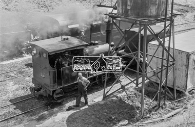
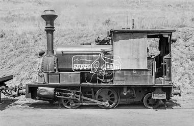
Photograph, George Coop, No. 6 locomotive, a Hudswell Clarke 0-4-2SToc locomotive, Fyansford Cement Works Railway, c.Feb. 1964
Narrow gauge private railwayDigital TIFF file Scan of 35mm Ilford FP3 black and white transparencyfyansford cement works railway, geelong, george coop collection, hudswell clarke 0-4-2stoc locomotive -
 Eltham District Historical Society Inc
Photograph, George Coop, No. 6 locomotive, a Hudswell Clarke 0-4-2SToc locomotive, Fyansford Cement Works Railway, c.Feb. 1964
Narrow gauge private railwayDigital TIFF file Scan of 35mm Ilford FP3 black and white transparencyd-class diesel locomotive, fyansford cement works railway, geelong, george coop collection, hudswell clarke 0-4-2stoc locomotive -
 Eltham District Historical Society Inc
Photograph, George Coop, No. 6 locomotive, a Hudswell Clarke 0-4-2SToc locomotive, Fyansford Cement Works Railway, c.Feb. 1964
Narrow gauge private railwayDigital TIFF file Scan of 35mm Ilford FP3 black and white transparencyfyansford cement works railway, geelong, george coop collection, hudswell clarke 0-4-2stoc locomotive -
 Eltham District Historical Society Inc
Photograph, George Coop, No. 6 locomotive, a Hudswell Clarke 0-4-2SToc locomotive, Fyansford Cement Works Railway, c.Feb. 1964
Narrow gauge private railwayDigital TIFF file Scan of 35mm Ilford FP3 black and white transparencyfyansford cement works railway, geelong, george coop collection, hudswell clarke 0-4-2stoc locomotive -
 Eltham District Historical Society Inc
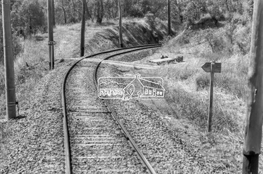
Photograph, George Coop, Derailment guard rails on the Hurstbridge line as the track crosses the Diamond Creek just north of Allendale Road, Diamond Creek, 6 December 1980, 1980
The device pictured is intended to prevent severe derailment and to keep errant trains in line with track when going over culverts or similar should they become derailedDigital TIFF file Scan of 35mm Ilford FP4 black and white transparencyallendale road, derailment guard rail, diamond creek, railway bridge -
 Eltham District Historical Society Inc
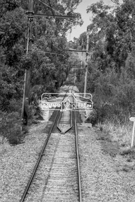
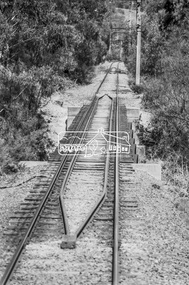
Photograph, George Coop, Heading towards Eltham, Hurstbridge Line, near Eltham North, 6 December 1980, 1980
View from driver's cabinDigital TIFF file Scan of 35mm Ilford FP4 black and white transparencyeltham north, hurstbridge line -
 Eltham District Historical Society Inc
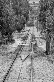
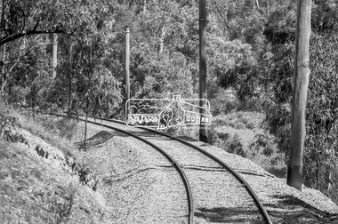
Photograph, George Coop, Approaching Hurstbridge Railway Station, Eltham - Hurstbridge, 6 December 1980, 1980
View from driver's cabinDigital TIFF file Scan of 35mm Ilford FP4 black and white transparencyhurstbridge line, hurstbridge railway station -
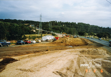 Eltham District Historical Society Inc
Photograph, Fitzsimons Lane bridge duplication; 6 Feb 1991, 06/02/1991
Colour photograph1991, fitzsimons lane, bridge construction, streets -
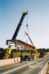 Eltham District Historical Society Inc
Photograph, Fitzsimons Lane bridge duplication; 6 Jul 1991, 06/07/1991
Colour photograph1991, fitzsimons lane, bridge construction, streets -
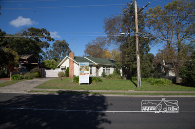
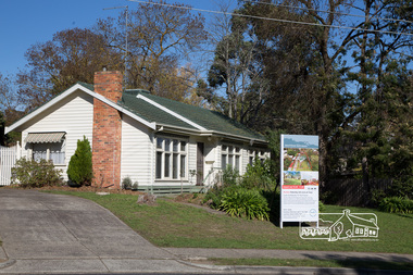
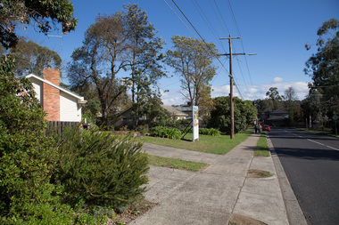
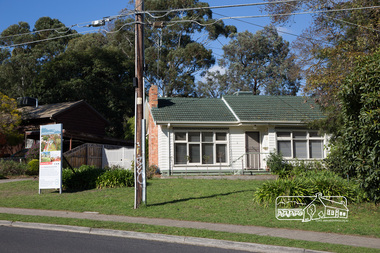 Eltham District Historical Society Inc
Photograph, Peter Pidgeon, 6 Grove Street, Eltham, 20 May 2017
Streetscape changesBorn Digitaleltham, grove street -
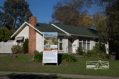 Eltham District Historical Society Inc
Photograph, Peter Pidgeon, 6 Grove Street, Eltham, 20 May 2017
Streetscape changesBorn Digitaleltham, grove street -
 Eltham District Historical Society Inc
Photograph, Peter Pidgeon, 6 Grove Street, Eltham, 20 May 2017
Streetscape changesBorn Digitaleltham, grove street -
 Eltham District Historical Society Inc
Photograph, Peter Pidgeon, 6 Grove Street, Eltham, 20 May 2017
Streetscape changesBorn Digitaleltham, grove street -
 Eltham District Historical Society Inc
Photograph, Peter Pidgeon, 6 Grove Street, Eltham, 20 May 2017
Streetscape changesBorn Digitaleltham, grove street -
 Eltham District Historical Society Inc
Photograph, Liz Pidgeon, Heritage Excursion; East of Eltham, 6 Sep 2014, 20 May 2017
Newsletter No. 218, September 2014 September Excursion - East of Eltham Walk In Newsletter No. 197, March 2011, there was a brief history of Crown Allotment 15 Section 5 Parish of Nillumbik (CA 15) a parcel of land of a quarter of a square mile extending from Eucalyptus Road to Reynolds Road at the eastern extremity of Eltham. From the 1940s it was known as Stokes orchard. In later years it has been subdivided for residential purposes but leaving significant areas as power line and water supply reserves and bushland reserves that are habitat for the threatened For our excursion on 6th September we intend to walk through CA 15 to a bushland reserve east of Reynolds Road. The walk will traverse the boundary between suburban Eltham and the non-urban areas to the south and east. This is a pleasant walk through residential areas and bushland. Along the way we will discuss the early and more recent history of CA 15 as well as local natural history and geology. This walk is about 3.5 km in length and will take 2 to 2.5 hours. It will start at 2pm at the corner of Eucalyptus Road, Pitt Street and Nyora Road.Born Digitaleltham east, eltham district historical society, heritage excursion, activities, nyora road, reynolds road, gum tree road reserve, diosma road, stokes orchard, eucalyptus road -
 Eltham District Historical Society Inc
Photograph, Liz Pidgeon, Heritage Excursion; East of Eltham, 6 Sep 2014, 20 May 2017
Newsletter No. 218, September 2014 September Excursion - East of Eltham Walk In Newsletter No. 197, March 2011, there was a brief history of Crown Allotment 15 Section 5 Parish of Nillumbik (CA 15) a parcel of land of a quarter of a square mile extending from Eucalyptus Road to Reynolds Road at the eastern extremity of Eltham. From the 1940s it was known as Stokes orchard. In later years it has been subdivided for residential purposes but leaving significant areas as power line and water supply reserves and bushland reserves that are habitat for the threatened For our excursion on 6th September we intend to walk through CA 15 to a bushland reserve east of Reynolds Road. The walk will traverse the boundary between suburban Eltham and the non-urban areas to the south and east. This is a pleasant walk through residential areas and bushland. Along the way we will discuss the early and more recent history of CA 15 as well as local natural history and geology. This walk is about 3.5 km in length and will take 2 to 2.5 hours. It will start at 2pm at the corner of Eucalyptus Road, Pitt Street and Nyora Road.Born Digitaleltham east, eltham district historical society, heritage excursion, activities, nyora road, reynolds road, gum tree road reserve, diosma road, stokes orchard, eucalyptus road