Showing 2558 items
matching aerial
-
 Eltham District Historical Society Inc
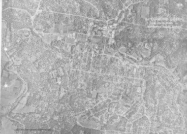
Work on paper (Sub-Item) - Aerial Photograph, Diamond Creek from Yarra River to Wattletree Road, Eltham
Black and white aerial photograph witrh key features around the central place of Eltham township marked inluding Yarra River, Main Road, Bridge Street and Ryans Road, Eltham North land development, real estate, aerial view, eltham, eltham north -
 Moorabbin Air Museum
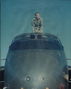
Manual (Item) - Jindivik Target Program
Description: 40 pages. Published by CSIRO. Published 1/1/1973. Division of Soils Technical Paper No. 19. Aerial Photography Techniques and Doctrines for Agricultural Field Trials. Level of Importance: World. -
 Bendigo Historical Society Inc.
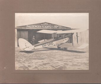
Photograph - T.B.T. Aviation Co
The Bendigo Aero Club laid out the Myers Flat aerodrome in 1929 to serve as an airport for Northern Victoria and the Riverina. In May 1929, 12 machines arrived to give an aerial display to local citizenry.Black and white photograph glued to brown cardboard. Photo of a single engine propeller plane in front of a shed. The sign on the shed reads: T.B.T. Aviation Co. Passenger flights from 10 shillings every Saturday, Sunday and Holiday. Markings on the plane: VH-UHG Eaglehawk. Two men are standing, and one is in the cockpit of the plane. Part of the Barker's family collection.At "Drome" Myers Flat. Left to right: O'Halloran, Cyril James (brother of Emmie Barker nee James), J.S. Barker.myers flat, aviation, tbt aviation -
 Heidelberg Golf Club
Album - Photograph Album, Heidelberg Golf Club, Clubhouse redevelopment, 1998; Course development,2000-2001; Course redesign, 1967, 1967-2001
Album containing about 70 color photographs of Clubhouse redevelopment, 1998; Course development,2000-2001; Course redesign, 1967. Includes aerial photographs of golf club, some stamped "proof"Album #2 in the photograph collection at HGCBlack spiral bound album. Contains approx. 70 colour photographs of various sizes.heidelberg golf club, clubhouse redevelopment 1998, course design 1967, heidelberg golf course -
 Eltham District Historical Society Inc
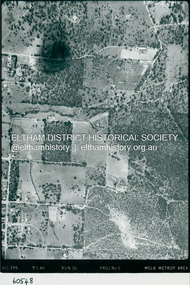
Photograph - Aerial Photograph, Landata, Eltham, Luck St; Bible St to Beard St, Dec. 1945
Centred on present day Eltham East Primary School, east of Main Rd along Luck St to Beard St Historic Aerial Imagery Source: Landata.vic.gov.au Aerial Photo Details: Project No :5 Project : MELBOURNE AND METROPOLITAN AREA PROJECT Run : 36 Frame : 60548 Date : 12/1945 Film Type : B/W Camera : EAG4 Flying Height : 10200 Scale : 6000 Film Number : 195 GDA2020 : 37°42'46"S, 145°09'18"E MGA2020 : 337371, 5824456 (55) Melways : 22 A4 (ed. 42)aerial photo, eltham, arthur street, beard street, bible street, eltham east primary school, frank street, henry street, luck street, stanley avenue, wycliffe crescent, neil webster collection -
 Eltham District Historical Society Inc
Photograph - Aerial Photograph, Landata, Eltham, Main Rd; Railway Rd to Zig Zag Rd, Dec. 1945
Centred on present day Edendale Farm from Glen Park rd to Zig Zag Rd Historic Aerial Imagery Source: Landata.vic.gov.au Aerial Photo Details: Project No :5 Project : MELBOURNE AND METROPOLITAN AREA PROJECT Run : 37 Frame : 60549 Date : 12/1945 Film Type : B/W Camera : EAG4 Flying Height : 10200 Scale : 6000 Film Number : 196 GDA2020 : 37°42'12"S, 145°09'09"E MGA2020 : 337141, 5825486 (55) Melways : 21 K2 (ed. 42)aerial photo, eltham, edendale farm, eltham - yarra glen road, eltham-hurstbridge railway line, gastons homestead, gastons road, glen park road, main road, park road, railway road, wattletree road, zig zag road, neil webster collection -
 Lara RSL Sub Branch
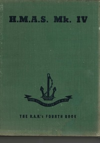
Book, HMAS Mk IV - The RAN's Fourth Book, 1945
This is the last of the series of books chronicling the achievements of the ships and personnel of the Royal Australian Navy in WWII. For the whole of the war the Navy was on the job all over the place all of the time. From the first to the last days of WWII RAN was represented, by ships and personnel in the battle for supremacy in t he battle for supremacy at sea. They took part in every rear-guard action in the days when the tide was against. They participated in the invasions of enemy territory that came with the resurgence of Allied strength right through to the final assaults on the Japanese home islands The last book of the series of which HMAS MK IV, servIng personnel of the RAN have recorded the achievements of their service in WWII HMAS Mk IV - The RAN's Fourth Book. Green front, back and spine hardcover.. Inside front and back cover is a green sepia aerials view illustration of Japanese islands with boats and aeroplane. Illustrations, poems, stories, photographs, prints, cartoons.Dedicated to all those past and present, who 'Fear God, Honour the Kingwwii, royal australian navy, triumph of sea power, amphibian, flying seaman, invasion of borneo, whaler's crew, converted ocean liners, wrans go to sea, balikpapan, frigates, new guinea, indonesia, south east oceania, bougainville, surrender of dutch borneo, world war 2 -
Glenelg Shire Council Cultural Collection
Photograph - Photograph - aerial view of Portland, c. 1954
Black and white aerial photograph of coastline around Portland. Black border, scale all sides, 5 rows of 3 't' at regular intervals. Bottom half ocean, top half land, separated by beach, further left than 8471Front: '607 - 90 ' - handwritten, white, borderaerial photography, central portland, portland harbour, south west coastline -
 Bendigo Historical Society Inc.
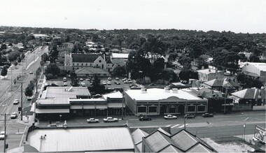
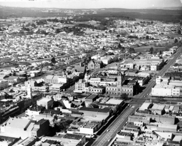
Photograph - AERIAL VIEW: BENDIGO, 1995
Black and white photo: aerial view from St. Paul's church tower showing Bush's store in foreground. St. Andrew's church middle distance, Myers St. at left front to middle distance. Williamson St. left to right foreground.Peter Hyettplace, aerial view of bendigo -
 Port Melbourne Historical & Preservation Society
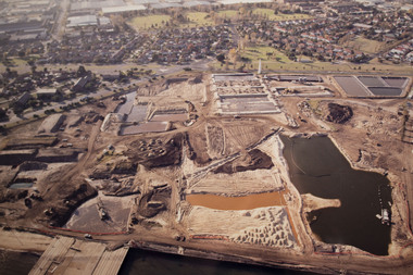
Photograph - Aerial view Beacon Cove area during soil cleaning operation, 1990
Framed colour aerial photograph of the Beacon Cove area during the soil cleaning operation prior to building the project. Area covered: from Beacon Road to Bain Street, and from the beach to the rear beacon. Foot of Princes Pier also shown.environmental issues -
 Bendigo Historical Society Inc.
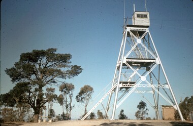
Slide - PETER ELLIS COLLECTION: SLIDE, May 1970 - Jan 1972
Coloured slide transparency. Image is of a tall metal tower on top of a hill. The tower is white and a ladder is visible on the right hand side. There are two aerials and a wooden building on the top platform. A tree with a picnic table and chairs at the bottom is on the right hand side.Kodachrome Transparencyslide, bendigo, bendigo institute of technology -
 Bendigo Historical Society Inc.
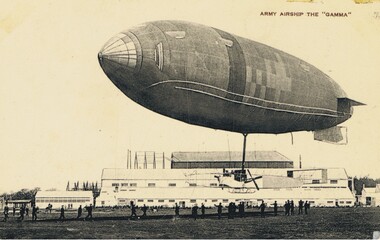
Postcard - BASIL WATSON COLLECTION: POSTCARD, ARMY AIRSHIP 'THE GAMMA', ca. 1914
Black and white postcard. Written in top RH corner: ' Army Airship The Gamma' Image shows tethered army airship with ground-crew holding airship down with lines. Large buildings, possibly hangars, in background. 'Our Aerial Defence' Series.John Drew, Aldershot & Farnboroughmilitary, aviation, airship 'the gamma' -
 National Vietnam Veterans Museum (NVVM)
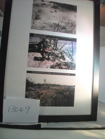
Photograph
Framed and glass fronted photograph. Three panel photograph 1. Aerial shot of battlefield-tanks and soldiers pictured 2. Checking captured weapons. Soldier in kneeling position holding rifle. 3. Troops returning with NVA prisoners. Four pictured.CORAL BALMORAL COLLECTIONtanks, prisoners, photograph, battle of coral-balmoral -
Whitehorse Historical Society Inc.
Map, Dandenong Ranges area. Sheet 7, c1957
Detailed map covering area from Mitcham and Vermont to Ringwood and Heathmont.Detailed map covering area from Mitcham and Vermont to Ringwood and Heathmont. Shows streets, block boundaries, buildings, railway and creeks. Note says prepared from State Aerial Survey, April 1954 and Cadastrial Survey information July 1956.Detailed map covering area from Mitcham and Vermont to Ringwood and Heathmont. maps, mitcham, vermont, ringwood, heathmont -
 Whitehorse Historical Society Inc.
Photograph, Tally Ho Office Park, 1995
Aerial view of Tally Ho Office Park on corner of Springvale Road & Burwood Highway, East Burwood. Site partly developed. Shows East Burwood Reserve (part) and Bill Sewart Athletics Track. Photo taken facing Burwood Highway.lend lease development pty ltd, tally ho office park, springvale road burwood east, burwood highway burwood east, bill sewart athletic track -
 Bendigo Historical Society Inc.
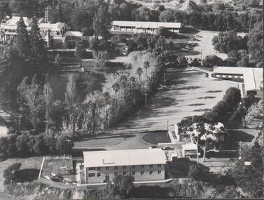
Photograph - FORTUNA COLLECTION - PHOTOGRAPH
Black and white photograph, aerial view of part of grounds showing some buildings, partial view of lake and partial view of Fortuna Villa. Writing in pen on back of photo (top left hand side) is an inscription stating 'approx 1962-3'. -
 Falls Creek Historical Society
Poster - Kangaroo Hoppet 2018
The Kangaroo Hoppet is Australia’s premier long distance cross country ski race, and a member of the Worldloppet series of international cross country ski events. The first race at Falls Creek was held in 1979 under the name of “Australian Birkebeiner”. It was a 21km race with about 80 participants organised by the Birkebeiner Nordic Ski Club of Mount Beauty. The course started and finished at Falls Creek Alpine Resort and took participants out into the Bogong High Plains. After running the event for 10 years, it was decided they should become part of the Worldloppet series of marathon ski races. Representatives from the Birkebeiner Nordic Ski Club and the Australian Ski Federation attended the Worldloppet Annual Meeting in Finland in June 1990 to put the case for the acceptance of an Australian event into the Worldloppet series. Before being admitted, they had to demonstrate that the Birkebeiner Club could run a world class event, so three months later in August 1990 a 42km event named the Australian International Ski Marathon was held at Falls Creek together with a 21km Birkebeiner race and a 7km event called the Birkebeiner Lite. The event was approved by delegates from USA, Norway and Austria, in 1991 Australia became the 12th member of Worldloppet, with the condition that there had to be a name change. After some late night discussion allegedly involving red wine from North East Victoria the main event became the 42km Kangaroo Hoppet, with the minor events being the 21km Australian Birkebeiner, and 7km Joey Hoppet. In the winter of 1991, the first Kangaroo Hoppet was held. It was a great success and has been a regular fixture on the international ski calendar ever since. It features the main 42km event as well as a 21km event and a 7km event. The Hoppet brings the Australian snowfields to an international audience. In 2018 the Men's Winner was Valerio Leccardi from Switzerland in a time of 1:39:55. The winner of the Women's event was Barbara Jezersek of Australia in a time of 1:52:59. This poster is significant because it documents an event which brings international attention to Falls Creek and the surrounding region.A poster featuring an aerial view of a Hoppet event with smaller image in diamond shapes on the right. Logos of Worldloppet, AGL, Falls Creek, Alpine Shire Council, Victorian State Government, the Birkebeiner Nordic Ski Club and FIS are across the bottom of the poster. Text: KANGAROO HOPPET 25 August 2018 FALLS CREEK AUSTRALIA 7 km 21 km 42 km Beside the logos: www.hoppet.com.au kangaroo hoppet, worldloppet events, falls creek, mt. beauty -
 Lakes Entrance Historical Society
Photograph - Lakes Entrance, 1997c
Colour print of aerial view looking south of western side of township. Shows housing on Kalimna Hill, North Arm, part of Bullock Island, Cunninghame Arm, the outer barrier and east pier of man made entrance. Lakes Entrance Victoriawaterways, township -
 National Vietnam Veterans Museum (NVVM)
Photograph, Gibbons, Denis, Early Morning Check
Denis Gibbons (1937 – 2011) Trained with the Australian Army, before travelling to Vietnam in January 1966, Denis stayed with the 1st Australian Task Force in Nui Dat working as a photographer. For almost five years Gibbons toured with nine Australian infantry battalions, posting compelling war images from within many combat zones before being flown out in late November 1970 after sustaining injuries. The images held within the National Vietnam Veterans Museum make up the Gibbons Collection. A colour photograph of the Loadmaster on board an RAAF Caribou transport aircraft carrying out an early morning check, including washing the windscreen, prior to commencing the days alloted tasks. The Caribou's of 35 Squandron were Australia's aerial work horses in Vietnam.photograph, raaf, caribou, 35 squadron, gibbons collection catalogue, denis gibbons, photographer, vietnam war, loadmaster -
 Lakes Entrance Historical Society
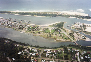
Photograph - Lakes Entrance, Gippsland Ports, 2006 c
Second copyColour aerial photograph of entrance from Bass Strait to Gippsland Lakes including Bullock Island Reeves Channel Rigby Island houses on Kalimna Hill and Princes Highway winding down Jemmys Point hill into township of Lakes Entrance Victoriaaerial photograph, ocean, waterways -
 Lara RSL Sub Branch
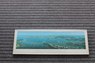
Framed Print of Naval Review,Sydney Harbour, 1st October,1988, Naval Review,Sydney Harbour, 1st October,1988, 12/01/1990
The bicentenary of Australia was celebrated in 1988. It marked 200 years since the arrival of the First Fleet of British convict ships at Sydney in 1788. This aerial photo shows naval and pleasure craft in Sydney Harbour for the bicentennial celebrations.The bicentennial year marked Captain Arthur Phillip's arrival with the 11 ships of the First Fleet in Sydney Harbour in 1788, and the founding of the city of Sydney and the colony of New South Wales. 1988 is considered the official bicentenary year of the founding of Australia. Rectangular shaped glass covered picture frame showing photo of Naval Review, Sydney Harbour, 1st October,1988Naval Review, Sydney Harbour, 1st October,1988 This 140 degree panoramic photograph was taken from a helicopter by Phil Gray. It shows the visiting warships in the harbour including the USS New Jersey, FNS Colbert and HMS Ark Royal in the foreground.This print is the fourth in the Sydney Harbour Panorama series by Phil Gray who uses Kodak film.Printed in Australia.prints, naval photos, hms ships, sydney harbour, lara r.s.l. -
 Greensborough Historical Society
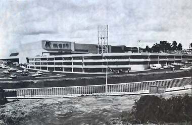
Photograph - Photograph - Digital Image, The Valley Voice, Greensborough Centre 1979, 24/01/1979
A view of the newly completed (1979) Greensborough Centre (now called Greensborough Plaza). Shows the exterior KMart sign and multi storey car park. Also an aerial view of the complex. Several photographs of the central area.Digital copy of newspaper articlegreensborough plaza, kmart greensborough -
 Ballaarat Mechanics' Institute (BMI Ballarat)
Aerial view looking south over Ballarat
ballarat, lydiart st, sturt st, armstrong st, aerial, view, above -
 Ballarat Heritage Services
Photograph - Photograph - Colour, Ballarat From the Regent Cinema, Lydiard Street North, Ballarat, 2015, 27/12/2016
Lydiard Street is known as an axcellent example of Victorian architecture.Various views of Ballarat's Lydiard Street Northballarat, lydiard street north, buildings, aerial, birds eye, sebastions, regent cinema -
 Eltham District Historical Society Inc
Photograph - Aerial Photograph, Landata, Research, Vic, Apr. 1963
Centred on present day Marconi Court, Research bounded by Maroondah Aqueduct to north, Thompson Crescent to south, Joselyn Drive to east and Eltham Research Oval to west. Historic Aerial Imagery Source: Landata.vic.gov.au Aerial Photo Details: Project No :486 Project : MELBOURNE (1963) PROJECT Run : 5 Frame : 62 Date : 04/1963 Film Type : B/W Camera : RC8 Flying Height : 5100 Scale : 9600 Film Number : 1805 GDA2020 : 37°42'24"S, 145°10'43"E MGA2020 : 339434, 5825157 (55) Melways : 22 F3 (ed. 42)aerial photo, neil webster collection, 1963-04, joselyn drive, marconi court, melway 22f3, research (vic.), research oval, thompson crescent -
 Eltham District Historical Society Inc
Photograph - Aerial Photograph, Landata, Research, Vic, Apr. 1972
Centred on present day Maroong Drive, Research bounded by Allendale Road to north, Thompson Crescent to south, Eltham College to east and Parsons Road to west. Historic Aerial Imagery Source: Landata.vic.gov.au Aerial Photo Details: Project No :985 Project : MELBOURNE 1972 Run : 26 Frame : 193 Date : 04/1972 Film Type : B/W Camera : RC10 Flying Height : 5700 Scale : 9600 Film Number : 2636 GDA2020 : 37°42'04"S, 145°10'33"E MGA2020 : 339187, 5825794 (55) Melways : 22 F1 (ed. 42)aerial photo, neil webster collection, 1972-04, allendale road, eltham, eltham barrel, eltham college, maroong drive, melway 22f1, parsons road, research (vic.), thompson crescent -
 Eltham District Historical Society Inc
Photograph - Aerial Photograph, Landata, Eltham, Vic, Apr. 1972
Centred on present day Ryans Road at Sandra Avenue, Eltham bounded by Progress Road to north, Brougham Street to south, Bible Street to east and Outlook Crescent to west. Historic Aerial Imagery Source: Landata.vic.gov.au Aerial Photo Details: Project No :985 Project : MELBOURNE 1972 Run : 27 Frame : 48 Date : 04/1972 Film Type : B/W Camera : RC10 Flying Height : 5700 Scale : 9600 Film Number : 2636 GDA2020 : 37°42'41"S, 145°08'38"E MGA2020 : 336392, 5824574 (55) Melways : 21 H4 (ed. 42)aerial photo, neil webster collection, 1972-04, eltham, bible street, brougham steet, melway 21h4, outlook crescent, progress road, ryans road, sandra avenue, montmorency -
 Eltham District Historical Society Inc
Photograph - Aerial Photograph, Landata, Montmorency, Vic, Apr. 1972
Centred on present day Olympic Avenue at Grand Boulevard, Montmorency bounded by Meruka Drive to north, Main Road to south, Main Road to east and Alban Street to west. Historic Aerial Imagery Source: Landata.vic.gov.au Aerial Photo Details: Project No :985 Project : MELBOURNE 1972 Run : 28 Frame : 206 Date : 04/1972 Film Type : B/W Camera : RC10 Flying Height : 5700 Scale : 9600 Film Number : 2635 GDA2020 : 37°43'21"S, 145°07'46"E MGA2020 : 335154, 5823329 (55) Melways : 21 E7 (ed. 42)aerial photo, neil webster collection, 1972-04, eltham, alban street, grand boulevard, lower plenty, main road, melway 21e7, meruka drive, montmorency, olympic avenue -
 Eltham District Historical Society Inc
Photograph - Aerial Photograph, Landata, Eltham, Vic, Apr. 1972
Centred on present day Mays Road at Stringybark Road, Eltham bounded by Nyora Road to north, Yarra River to south, Reynolds Road to east and Bible Street to west. Historic Aerial Imagery Source: Landata.vic.gov.au Aerial Photo Details: Project No :985 Project : MELBOURNE 1972 Run : 28 Frame : 209 Date : 04/1972 Film Type : B/W Camera : RC10 Flying Height : 5700 Scale : 9600 Film Number : 2635 GDA2020 : 37°43'33"S, 145°09'28"E MGA2020 : 337647, 5823013 (55) Melways : 22 B8 (ed. 42)aerial photo, neil webster collection, 1972-04, eltham, bible street, mays road, melway 22b8, nyora road, reynolds road, stringybark road, yarra river -
 Eltham District Historical Society Inc
Photograph - Aerial Photograph, Landata, Eltham, Main Road; Henry St to Bellevue Rd, Dec. 1945
Eltham, Main Road; Henry St to Bellevue Rd, and east along Luck St to present day Eltham East School Historic Aerial Imagery Source: Landata.vic.gov.au Aerial Photo Details: Project No :5 Project : MELBOURNE AND METROPOLITAN AREA PROJECT Run : 36 Frame : 60549 Date : 12/1945 Film Type : B/W Camera : EAG4 Flying Height : 10200 Scale : 6000 Film Number : 228 GDA2020 : 37°42'45"S, 145°08'59"E MGA2020 : 336903, 5824465 (55) Melways : 21 K4 (ed. 42)aerial photo, arthur street, bellevue road, bible street, diamond street, dudley street, elsa court, eltham, eltham east primary school, gahan house, henry street, livingstone road, luck street, main road, pryor street, neil webster collection