Showing 1526 items
matching aerial photograph
-
 Stawell Historical Society Inc
Photograph, Stawell Aerial View 1992 -- Colour
... grampians Colour Aerial View of Stawell 1992 Stawell Stawell Aerial ...Colour Aerial View of Stawell 1992stawell -
Stawell Historical Society Inc
Photograph, Stawell Aerial View 1933
... grampians Aerial Photo of Stawell 1933 stawell Stawell Aerial View ...Aerial Photo of Stawell 1933stawell -
Stawell Historical Society Inc
Photograph, Stawell Aerial View from a Souvenir photo from the Melbourne Argus Newspaper 1936
Aerial Views of Stawell 1933. Argus newspaper. Looking West along Main Street in centre of photo.stawell -
Stawell Historical Society Inc
Photograph, Stawell Aerial View showing many of Stawell distinctive buildings 1998 -- Coloured
stawell -
Stawell Historical Society Inc
Photograph, Stawell Aerial View Centred on Town Hall in Main Street 1998 -- Coloured
Colour Aerial View of Stawell 1998 Centred on Town Hall. Main Street. Scallan Street Childe Street Houston Street and Ligar Street.stawell -
Stawell Historical Society Inc
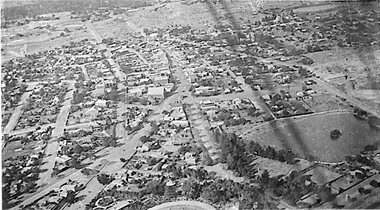
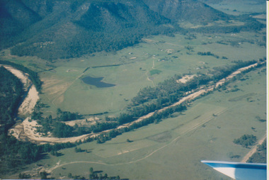
Photograph, Stawell Aerial View Centred on the Woollen Mills and Stawell Timber Industries 1955
B/W Aerial view of Stawell centred on Woollen Mills and Stawell Timber Industries 7th April 1955.stawell sti -
 Stawell Historical Society Inc
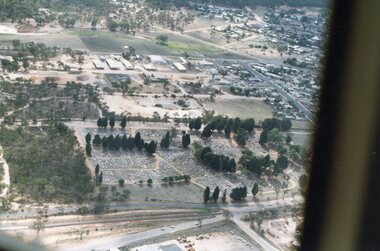
Photograph, Stawell Cemetery, Aerial View -- 2 Photos -- Coloured
Stawell Cemetery (Aerial Photos)stawell -
 Stawell Historical Society Inc
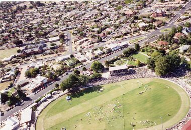
Photograph, Central Park -- Aerial Photo 1995
... Park -- Aerial Photo 1995 Photograph ...Central Park (Aerial Photo) 1995stawell sport -
 Stawell Historical Society Inc
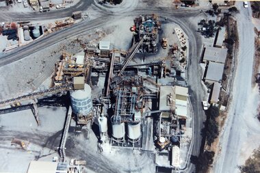
Photograph, Stawell Gold Mine -- Aerial photo 1998
... Mine -- Aerial photo 1998 Photograph ...Stawell Gold Mine 1998 - Aerial photostawell -
 Stawell Historical Society Inc
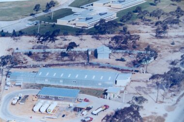
Photograph, B P Petrol Depot on the Western Highway -- Aerial View -- Coloured
... grampians Aerial View along Western Highway (BP Depot) Stawell B P ...Aerial View along Western Highway (BP Depot)stawell -
 Stawell Historical Society Inc
Photograph - 1919 Aerial View Over Stawell, Main Street Area Looking toward Big Hill 1919-- Aerial View
... Photograph 1919 Aerial View Over Stawell ...Aerial View – Main Street Area 1919 Looking toward Big HillAerial View over Stawell taken by R J McClure 1919stawell -
 Vision Australia
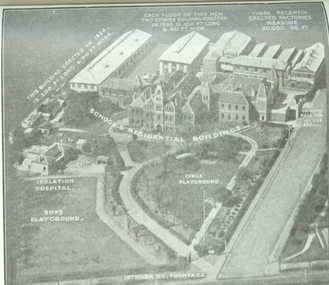
Photograph - Image, Aerial view of the Royal Victorian Institute for the Blind grounds in St Kilda Road, 1927
Aerial photo of the RVIB St Kilda Road buildings and grounds, scanned from an unknown printed source. On the image are written descriptions of buildings, including the width and length of those erected in 1920's, the isolation hospital and the segregation of boys and girls playing areas. 1 scanned image of RVIB St Kilda Road from airGirls playground School & residential buildings Boys playground Isolation hospital This building, erected in 1926 - is 200 ft long & 40 ft wide Each floor of this new two storied building erected in 1926 is 100 ft long & 40 ft wide These recently erected factories measure 20,000 sq ft Ormond Hall for socials, etc. St Kilda Road frontageroyal victorian institute for the blind, buildings -
 Port Fairy Historical Society Museum and Archives
Photograph, c. 1925
... Street Port Fairy great-ocean-road Black and white aerial ...Black and white aerial of Martins Point Moyne River showing dredge. The original signed by R. W. Golding.Black and white landscapelocal history, photography, photographs, slides, film, aerial, martins point, moyne river, dredge -
 Port Fairy Historical Society Museum and Archives
Photograph - Photographs, 1973
Overview of the town in 1973Aerial views from the tower at St Johns Anglican Churchaerial, town, port fairy -
 Port Fairy Historical Society Museum and Archives
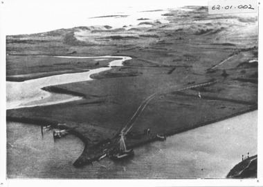
Photograph, R.W.Golding, 1925
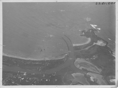
taken in 1925 by W Golding Aerial-Port Fairy Harbour 1925Black and White aerial view of Port Fairy ‘s waterways62.01.001 on front of photograph - on the back-Port Fairy Moyne River Entrance W Goldingaerial view, harbour, griffiths island, w.golding, training walls -
 Port Fairy Historical Society Museum and Archives
Photograph, 1940's
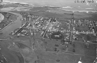
The photograph depicts the river, bridge, rail line, Regent Street, Sackville Street, William Street and south west passage and pudney groundsSignificant for its depiction of the layout of the town in the 1940's and the river and south west passageBlack and white photograph Oblique Port Fairy Streets looking SouthALEX WILKINS PHOTOGRAPHER WARRNAMBOOL O.G.Powell Chemist Phone 88 Port Fairy Handwritten- Aerial View to be enlarged to 12" wide underlined 62.01.006 written on front of picturemoyne river, sackville street, william street, south west passage, pudney gorunds -
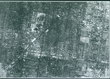
University of Melbourne, Burnley Campus Archives
Photograph - Black and white print, Aerial View of Burnley Campus, 1977
Framed enlargements. (A) Burnley College and surrounding suburbs showing the nearly constructed Freeway, the College in the bend of the Yarra River, Glenferrie Road to the East Swan Street to the North. (B) Enlargement of (A) showing detail of Burnley College.burnley college, suburbs, freeway, yarra river, glenferrie road, east swan street, aerial view -
University of Melbourne, Burnley Campus Archives
Photograph, Aerial View of Burnley Campus
-
 Surrey Hills Historical Society Collection
Photograph - Aerial view Riversdale Heights Estate area, c1923
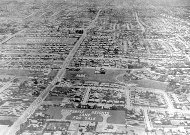
... paper. Photograph Aerial view Riversdale Heights Estate area ...This was probably part of a real estate promotion for the sale of the Riversdale Heights Estate. This was subdivided by Messrs. Duncan and Weller. Of the allotments offered, 30 were sold and realised £4600. Date of this sale was c December 1923. This suggests that the date This are was one of the last pieces of former rural land to be sub-divided for housing in Surrey Hills.The land between it and South Surrey Park was sub-divided post WW1, hence the naming of the streets after sites of WW1 battles.A black and white reproduction of an aerial photo of the area near the corner of Warragul and Riversdale Roads looking west towards the city. Some features have been identified by name including the Riversdale Heights Estate, which was being sub-divided. North and South Courts are shown. Other roads (unmarked) in the foreground are Graham Street, Allie Street, Thistle Street, Lille Street, Amiens Street, and Marne Street. Beyond these is the area marked 'PARK' (South Surrey Park), which is devoid of vegetation. Areas of Camberwell and Canterbury are also shown. The area covered extends to beyond St Dominic's Church. The original is mounted on a cream deckle-edged paper.Beneath the original on the mount: "SOUTH SURREY HILLS LOOKING WEST c. 1936" [The reference to the sale in the Box Hill Reporter of December 1923 found on Trove suggests that this date is not accurate.] Rear top LH corner of original in Jocelyn Hall's handwriting: "For Centre / from Mr James Long"riversdale heights estate, riversdale road, allie street, south surrey park, lille street, thistle street, amiens street, marne street, south court, north court, duncan and weller, real estate sales, graham street, st dominics church, highfield park, canterbury primary school, aerial photo -
 University of Melbourne, Burnley Campus Archives
Photograph - Black and white print, Airspy, Aerial View of Burnley Campus c. 1930, c. 1930
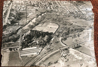
Taken before the Boulevard was built, and probably before the flood of 1934. Therefore probably 1929-1934. Information provided by TH Kneen and EB LittlejohnColour photograph of black and white photograph. Photograph of Burnley Campus and large area of surrounding suburbs of Hawthorn and Toorak. It shows the Carter Oval, later modified, the Plant Research Institute (built 1929) and the Box Thorn Hedge (Lycium ferrocissimum).burnley campus, suburbs, hawthorn, toorak, carter oval, plant research institute, boxthorn hedge, lycium ferrocissimum -
 University of Melbourne, Burnley Campus Archives
Photograph - Colour print, Aerial View of Countryside
... photographs taken from a small aeroplane. Views of countryside. Aerial ...4 photographs taken from a small aeroplane. Views of countryside.aeroplane, countryside, aerial views -
Port Fairy Historical Society Museum and Archives
Photograph
Aerial view across the Moyne river Black and white photograph of Martins Point, river moyne and the pudney grounds from the air aerial, moyne, river, martin's point, port fairy, barge, dredge, pudney ground, griffith island -
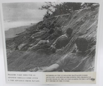 Beechworth RSL Sub-Branch
Photograph Laminated, Diggers take shelter as Japanese shells come over on the advance from AITAPE PNG
Actual photograph taken in the battlefield Actual battlefield photographer A laminated photograph depicting diggers taking cover during aerial and mortar attack in PNG 1945on bottom right corning on paper held inn place with adhesive tape: MEMBERS OF THE 2/2 INFANTRY BATTALION UNDER / ARTILLERY AND MOTAR FIRE DURING THE CROSSING OF / MANIB CREEK ON 16/3/1945 LEADING TO THE CAPTURE OF / BUT DROME ON THE 17/3/1945; on the bottom left hand side DIGGERS TAKE SHELTER AS / JAPANESE SHELLS COME OVER / ON THE ADVANCE FROM AITAPE.photograph, laminated photograph -
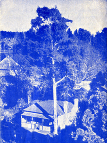 Friends of Ballarat Botanical Gardens History Group
Work on paper - Adam Lindsay Gordon, Australian Poet, Souvenir from Adam Lindsay Gordon's Cottage, Unknown
This leaflet gives a chronology of Gordon's life and a photograph of him. And printed on the other side, besides the aerial view of the cottage is a paragraph about the two years he spent in the cottage, 1867-1868 three short extracts of his poetry.Documents available and newspaper extracts make it clear that some Ballarat Citizens were proud of their city's association with this poet. 1 yellow leaflet printed on both sides in blue, with a photo of Gordon on the right side of p.1 and an aerial view of the Cottage off-centre on p.2. Originally folded twice.Noneadam lindsay gordon, adam lindsay gordon cottage, john garner, doctor, ballarat botanic gardens, craig's hotel, australian poet, friends of ballarat botanical gardens, john garner collection, poet, gardens, ballarat -
Canterbury History Group
Ephemera - Magic of Maling Road, 1/02/2011 12:00:00 AM
Real estate advertisement from the Weekly Review for the auction on 12 March 2011 of 29 Maling Road Canterbury. Includes coloured photographs of the exterior and an aerial view of the site.canterbury, maling road, land sales -
 Camberwell Historical Society
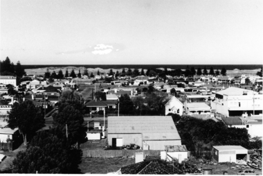
Photograph, Camberwell Victoria, aerial view of the District, c. 1940
Print of photograph with inscription 'Camberwell Victoria, aerial view of the District, c. 1940' Camberwell Victoria, aerial view of the District, c. 1940camberwell -
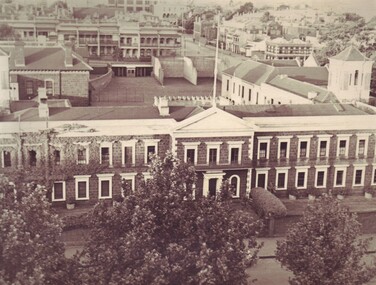 St Patrick's Old Collegians Association (SPOCA)
Photograph - Buildings, Aerial, c.1950
... melbourne SPJC from South (c.1950) Photograph Buildings, Aerial, c ... -
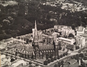
 St Patrick's Old Collegians Association (SPOCA)
Photograph - Buildings, Aerial, c.1960
... melbourne SPJC & Environs from Cathedral Spire (c.1960) Photograph ... -
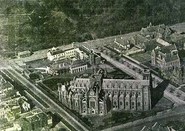 St Patrick's Old Collegians Association (SPOCA)
Photograph - Buildings, Aerial, c.1920
... ) Photograph Buildings, Aerial, c.1920 ... -
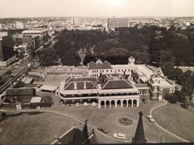
 St Patrick's Old Collegians Association (SPOCA)
Photograph - Buildings, Aerial, c.1970
... Kelley) Photograph Buildings, Aerial, c.1970 ...