Showing 10631 items
matching maps
-
 Bendigo Historical Society Inc.
Map - WELLSFORD, 15/10/1903
Map: Parish of Wellsford, County of Bendigo. Parish plan (number 321 in map cupboard 1)map, bendigo, parish plan, wellsford -
Bendigo Historical Society Inc.
Map - HEATHCOTE, 11/04/1935
Map: Parish of Heathcote, County of Dalhousie. Parish plan (number 320 in map cupboard 1)map, dalhousie, parish plan, heathcote -
Bendigo Historical Society Inc.
Map - TALAMBE, 26/11/1880
Map: Parish of Talambe, County of Bendigo. Parish plan (number 315 in map cupboard 1)map, bendigo, parish plan, talambe -
Bendigo Historical Society Inc.
Map - PANNOOBAMAWM, 6/11/1882
Map: Parish of Pannoobamawm, County of Bendigo, Parish plan (number 314 in map cupboard 1)map, bendigo, parish plan, pannoobamawm -
Bendigo Historical Society Inc.
Map - MARONG, 21/01/1916
Map: Parish of Marong, County of Bendigo. Parish plan. Map dated 21/01/1916map, bendigo, parish plan, marong -
Bendigo Historical Society Inc.
Map - YALLOOK, 25/02/1876
Map: Parish of Yallook, County of Bendigo. Parish plan. Map dated 25/02/1876.map, bendigo, parish plan, yallook -
Bendigo Historical Society Inc.
Map - PANNOOBAMAWM, 7/12/1914
Map: Parish of Pannoobamawm, County of Bendigo. Parish plan (number 313 in map cupboard 1)map, bendigo, parish plan, pannoobamawm -
Bendigo Historical Society Inc.
Map - SEDGWICK, 5/04/1881
Map: Parish of Sedgwick, County of Bendigo. Parish plan (number 312 in map cupboard 1)map, bendigo, parish plan, sedgwick -
Whitehorse Historical Society Inc.
Document, Walker Estate Mitcham, 8/10/1938 12:00:00 AM
Auction brochure for 'Beautiful brick residence' of 9 rooms, with 1 1/2 acres of grounds, subdivided into 12 sites for brick residences, Saturday 8th October 1938.Auction brochure for 'Beautiful brick residence' of 9 rooms, with 1 1/2 acres of grounds, subdivided into 12 sites for brick residences, Saturday 8th October 1938, by order of the Executors of the late E. E. Walker. Frontages to Mitcham Road, Agra Street, Simla Street and Meerut Street. Auctioneers: Edward Haughton Pty Ltd and Drake & Co. Original copy framed, located in Map Drawer.Auction brochure for 'Beautiful brick residence' of 9 rooms, with 1 1/2 acres of grounds, subdivided into 12 sites for brick residences, Saturday 8th October 1938.walker, edgar edwardes, walker estate, mitcham road, mitcham, agra street mitcham, simla street mitcham, meerut street mitcham, drake & co., edward haughton pty ltd -
 Ithacan Historical Society
Photograph, Bill Florence arriving in Australia, 1922
This photograph was taken when Bill Florence (Vasilis Florias) arrived in Melbourne in 1922. Many migrants on their arrival in Australia were photographed within this backdrop. Copies of these photos were often sent to their families back in their homeland.A sepia photograph of a portrait view of a man framed within a map of Australia with the words 'Welcome To' across the top of the map. Around the map are sketches of Australian bush scenes, animals and the sea.immigration -
 Bendigo Historical Society Inc.
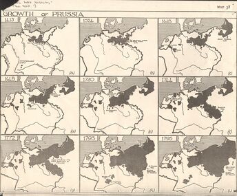
Map - GERMAN HERITAGE SOCIETY COLLECTION: GROWTH OF PRUSSIA
Photocopy of a map titled Growth of Prussia. Nine maps with the dates 1415, 1524, 1618, 1648, 1720, 1744, 1772, 1793 and 1795. Maps have letters (a) to (i) as well.map, german heritage society collection - growth of prussia-map 38 -
Bendigo Historical Society Inc.
Map - CAMPBELL COLLECTION: BENDIGO & DISTRICT MAPS
Map. Bendigo Whipstick, Scale 40 chains to 1 inch, Forests Commission Victoria, map N0.3, legend for roads and land and forest. (number 371 in map cupboard 1)map, bendigo, country lands -
 Greensborough Historical Society
Journal - Article, Journal, Victorian Historical Journal, Batman's route revisited: his exact steps to a new treaty site, 2014_06
Article from the Victorian Historical Journal Vol.85, No.1, June 2014. Discusses John Batman's 1835 visit to Port Phillip and possible alternative sites for signing his treaty with Indigenous people of the area.21 pages, maps.john batman, batmans treaty -
 Greensborough Historical Society
Map, Keelbundora. Counties of Bourke and Evelyn, 1950_11
Covers area bounded by Merri Creek, Yarra River, Plenty River and Crown Portions 24 to 28, with section including Maroondah Aqueduct and Darebin Creek.Photocopy of digitised mapkeelbundora (parish) -
 Federation University Historical Collection
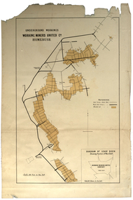
Plan, Underground Workings, Working Miners United Co. Homebush
Printed map on paper various measurements and locationsunderground workings, plan, working miners united co, homebush -
 Federation University Historical Collection
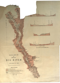
Plan, Geological Sketch Map of Portion of Big River
Printed map on paperscale, index to colours, sectionsgeological sketch map, plan, big river, mount wills, geology -
 Federation University Historical Collection
Map, Warragul, 1942, not dated
printed colour mapwarragul -
 Federation University Historical Collection
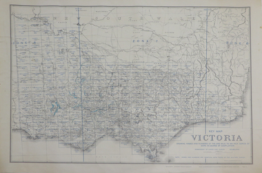
Map, Key Map of Victoria, 1917, 13/12/1917
Printed colour mapvictoria -
 Federation University Historical Collection
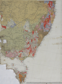
Map, South East Australia, not dated
Printed colour maptasmania, new south wales, victoria -
 Federation University Historical Collection
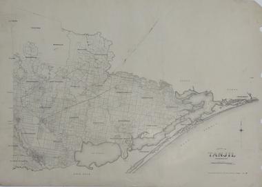
Map, County of Tanjil, 23/11/1906
Printed map on papertanjil -
 Federation University Historical Collection
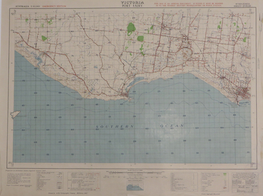
Map, Port Fairy, 1942
Printed colour mapport fairy, tower hill, killarney, armstrong bay, crossley, southern cross, kirkstall -
 Federation University Historical Collection
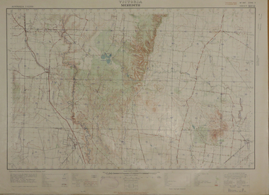
Map, Meredith, 1936, 08/1936
Printed colour mapmeredith, lethbridge, steiglitz, little river -
 Federation University Historical Collection
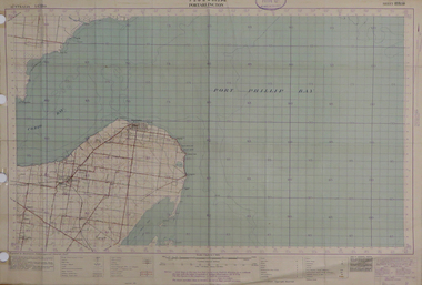
Map, Portarlington, 1929, 09/1929
Printed colour mapport arlington, corio bay, port phillip bay, clifton springs, swan bay, swan island, duck island, point wilson -
 Federation University Historical Collection
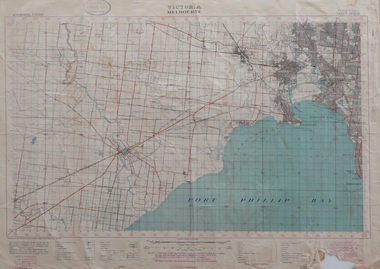
Map, Melbourne, Victoria, 1933
Printed colour map.melbourne, port phillip bay, werribee river, werribee, port melbourne, hobson's bay -
 Federation University Historical Collection
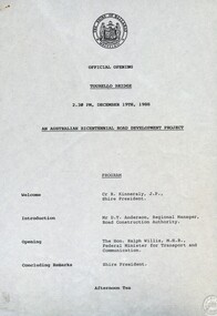
Documents, Tourello: Opening of Tourello Bridge; Tourello Hunt Club, 1909; Tourello Tennis Club; Government Land Auction, 1855
Maps and typed documentstourello bridge, hunt club, tennis club, government land auctions, talbot, clunes, coghill, lenaghan, peter lalor -
 Lara RSL Sub Branch
Book, Australia in the War of 1939-1945 - MEDICAL Middle East and Far East. Author Allan.S.Walker MD, Ch.M. F.R.A.C.P, First Published 1953
The complete record of the Medical conditions setting up camp hospitals, medical transport, medical records,Photographs, Maps,IllustrationsAustralian War Memorialtobruk, crete, general health in the desert, surgical conditions in the desert, syria, nurses, tropical medicine, malaria, medical conditions, burma thai railway, labour forces, prison camps -
 Eltham District Historical Society Inc
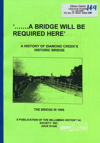
Book, Nillumbik Historical Society, '.......A Bridge Will Be Required Here': A history of Diamond Creek's historic bridge by Jock Ryan, 2005
7 pages, mapsdiamond creek, bridge -
Yarrawonga and Mulwala Pioneer Museum
Map, Map of Victoria, 1868
Original property of Alice Rebecca Puckey [nee Ford] Born England 23/07/1867 Died rosbud Vic 16/03/1951 Grandmother of Merven Elizabeth Clarke 30 Sturt st Mulwala1868 Map of Victoria -
Clunes Museum
Map, PHOTO LITHOGRAPHED AT DEPT OF LANDS & SURVEY, MELBOURNE BY J NOONE. SURVEYED BY EDWARD C COMPTON 6TH SEPTEMBER 1872
MAP OF ALLOTMENTS IN CLUNESlocal history, documents, map, township, clunes -
Koorie Heritage Trust
Book, Ballarat & District Aboriginal Co-op, Faded footprints walking the past
Faded Footprints relates the experiences of 8 indigenous people who grew up in institutions. The impact on their lives has been dramatic, they all acknowledge how they lost their culture and struggled to hang on to their identity.60P.; ports; maps.Faded Footprints relates the experiences of 8 indigenous people who grew up in institutions. The impact on their lives has been dramatic, they all acknowledge how they lost their culture and struggled to hang on to their identity. aboriginal community - stolen generations - interviews.