Showing 22380 items matching "will park"
-
 Bendigo Historical Society Inc.
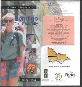
Document - BENDIGO NATURALLY TOURIST BROCHURE
District rural map describing topical walks and activities. Parks Vic, Bendigo Greater City publication.bendigo, tourism, natural environment -
 National Vietnam Veterans Museum (NVVM)
Audio - Audio, CD, Series of 22 Audio, CDs titled Chien sir Quan Luc VNCH (or similar)
In Vietnamese language - unable to read labels but address of supplier is PO Box 2054 Deer Park, Vicvietnamese language -
 Bendigo Historical Society Inc.
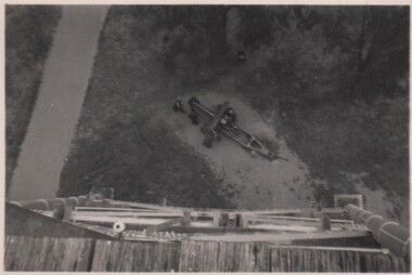
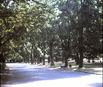
Photograph - GEORGE BOSOMWORTH COLLECTION: GUN IN ROSALIND PARK
Small black and white photograph showing a gun in Rosalind Park. The photo is dated 10/10/1952.photograph, landscape, bendigo -
 Bendigo Historical Society Inc.
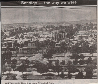
Newspaper - JENNY FOLEY COLLECTION: VISTA
Bendigo Advertiser ''The way we were'' from 1999. Vista: early Bendigo from Rosalind Park.newspaper, bendigo advertiser, the way we were -
Clunes Museum
Document - DOCUMENT POSTER, JEANETTE SPITTLE - UNIVERSITY OF MELBOURNE BURNLEY CAMPUS, QUEENS PARK CLUNES - A MANAGEMENT REVIEW
LAMINATED MANAGEMENT REVIEW FOR QUEENS PARK CLUNES. SHOWING MASTER PLAN. COMPLETED 2006. JEANETTE SPITTLEqueens park, clunes, management review, regional botanic gardens -
Tatura Irrigation & Wartime Camps Museum
Photograph, Victoria Hotel
Victoria Hotel with three vintage cars parked out the front; Penfolds sign hanging from balcony.tatura, buildings, historic, transport, motor, vehicles -
 Uniting Church Archives - Synod of Victoria
Photograph - B&W Photograph, Moyston Uniting Church
Moyston: Ararat Parishmoyston presbyterian church, moyston uniting church -
 Hume City Civic Collection
Photograph
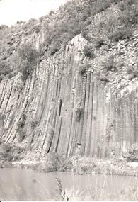
A black and white photograph of the unusual rock formation known as the Organ Pipes National Park in Diggers Rest.organ pipes national park, diggers rest, parks and reserves, national parks, evans, kevan, photographers, george evans collection -
Clunes Museum
Document - REPORT, ABBEY CARMICHAEL, THE HISTORY AND GRADUAL EVOLUTION OF QUEENS PARK CLUNES FROM 1900 TO THE PRESENT DAY, NOVEMBER 2006
PROJECT BY ABBY CARMICHAEL, A STUDENT IN THE FACULTY OF LAND AND FOOD RESOURCES, UNIVERSITY OF MELBOURNE, NOVEMBER 2006THE HISTORY AND GRADUAL EVOLUTION OF QUEENS PARK, CLUNES FROM 1900 TO THE PRESENT DAY, IN A BLACK - BOUND FOLDER.document, local history, queens park -
 Nillumbik Shire Council
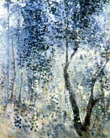
Painting: Tony Harkin (b.1938 Aus), Bush Study, Eltham, c.1977
A bush study of Eltham Park. Blue and green tones with the foliage of a tree in the foreground and trees and grasses in the background.Lower left, red paint: "TONY HARKIN 77" -
Stawell Historical Society Inc
Plan, North Park Master Plan, 2004
North Park Master Plan Northern Grampians Shire Council Final Report 2004 Spiral Boundnorth park, northern grampians shire -
Whitehorse Historical Society Inc.
Article, State park for our border, 2006
City of Whitehorse to have a state-controlled park at its border under a plan for Mullum Mullum Valley.City of Whitehorse to have a state-controlled park at its border under a plan for Mullum Mullum Valley.City of Whitehorse to have a state-controlled park at its border under a plan for Mullum Mullum Valley.city of whitehorse, state parks, mcinnes, ken, falkingham, cecily, friends of mullum mullum valley -
Whitehorse Historical Society Inc.
Document, East Burwood Reserve, 1/08/1992
Landscape guide lines, Prepared by Andrew Paxton Landscapes in conjunction with City of Nunawading Parks & Recreation Servicesparks & reserves, andrew paxton landscapes, east burwood reserve, city of nunawading parks and recreation services -
Whitehorse Historical Society Inc.
Document, Morack Golf Course, 1/04/1993
Morack Public Golf Course: Marketing Plan. City of Nunawading Parks and Recreations Services, April 1993morack golf course, city of nunawading, parks and reserves, abbott, kevin -
 Whitehorse Historical Society Inc.
Photograph, House in Humphries Avenue, Mitcham, 1998
Back view of House in Humphries Avenue, Mitcham, to be demolished. Taken from Car Park of Whitehorse Centre.humphries avenue, mitcham. -
 Whitehorse Historical Society Inc.
Photograph, Nunawading Youth Club, 1/10/2000 12:00:00 AM
Coloured photograph of Nunawading Youth Club building in Walker Park on corner Dunlavin and Whitehorse Roads, Mitcham.nunawading youth club, mitcham, walker park -
 Whitehorse Historical Society Inc.
Photograph, Husband Family Group outside Family Home 'Waroonga Park', Springvale Road, Forest Hill, C.1896
Photo of Husband Family Group outside Family Home 'Waroonga Park', Springvale Road, Forest Hill.husband, mary c, springvale road, tunstall, charles edward, waroonga park -
 Whitehorse Historical Society Inc.
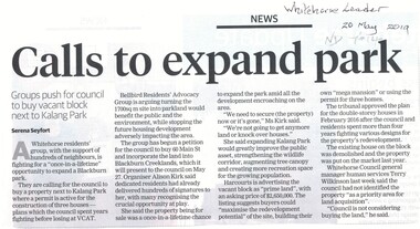
Article, Calls To Expand Park, 2019
Groups push for council to buy vacant block next to Kalang Park, at 60 Main Street, Blackburn.Groups push for council to buy vacant block next to Kalang Park, at 60 Main Street, Blackburn.Groups push for council to buy vacant block next to Kalang Park, at 60 Main Street, Blackburn.kalang park, bellbird dell residents committee, main street, blackburn no. 60, blackburn creeklands -
 Whitehorse Historical Society Inc.
Pamphlet, Bellbird Dell - Vermont, n.d
Bellbird Dell - Vermont, leaflet produced by City of Nunawading, Parks and Recreation Department. Includes details and map.bellbird dell, parks and reserves -
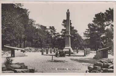 Rutherglen Historical Society
Postcard - Image, Soldiers' Memorial, Rutherglen, 1930s
Presented by the Corowa Historical Society to the Rutherglen Historical SocietyBlack and white postcard photograph of the Soldiers' Memorial erected after World War 1, in Rutherglen Parkrutherglen postcard views, tourism, commerce, soldiers' memorial, monuments, rutherglen park -
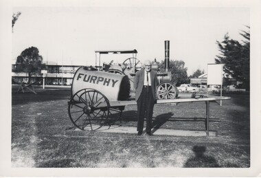 Rutherglen Historical Society
Image
Part of a collection relating to the Parkin family.Black and white photograph of a man standing in front of a Furphy water cart and other equipment displayed in a park.On back of photo: "Uncle Bob Mitchell"parkin family, furphy water cart, bob mitchell -
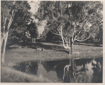 Rutherglen Historical Society
Image, Robert B Billings, c1953
Photograph of the Billings children at a picnic table at the side of Lake King.Black and white photograph of park with trees reflected on the surface of a lake. Several children are seated at a picnic table.Written on back of photo: "Rutherglen Lake. About 1953. (Stopped at [Browning?] Road)billings family, lake king, rutherglen park -
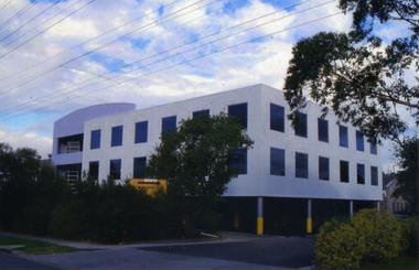 Whitehorse Historical Society Inc.
Photograph, Stanley Works Pty Ltd
Coloured photograph of the Stanley Works head office, Nunawading in 1989. Grey building with an underground car park.stanley works pty ltd tools manufacturing industry nunawading -
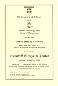 Ballarat and District Irish Association
Invitation, Invitation to the ground Breaking ceremony for the Proposed Greenhill Enterprise Centre, 1996, 1996
The Hon. Mark Birrell, MP, Minister for Industry, Science and Technology was involved with the Ground breaking ceremony held on Friday 13 September 1996 at 12.40pm.Cream coloured invitation to to the ground breaking ceremony for the proposed Greenhill Enterprise Centre at the Ballarat Technology Park.ballarat technology park, mark birrell, greenhill enterprise centre -
 Mt Dandenong & District Historical Society Inc.
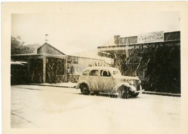
Photograph, Main Street Olinda c1950, c1950
c1950 Snow scene in Main Street Olinda with old car parked outside the store of J.H. Gill.olinda, main street, snow, j.h.gill, gill -
 Tennis Australia
Photographic print, Circa 2000
Framed colour photo of Rodlaver Arena and two showcourts at Melbourne Park Materials: Paper, Metal, Glasstennis -
 Bendigo Historical Society Inc.
Slide - DIGGERS & MINING: BENDIGO
Diggers & Mining: Bendigo. Rosalind Park, lower level. Markings: 02 DEC76M10. Used as a teaching aid.Kodachromeeducation, tertiary, bendigo -
 Buninyong & District Historical Society
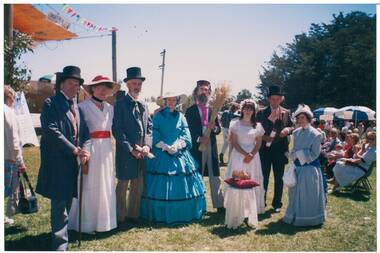
Photograph - Original Colour Photograph, Buninyong Gold King Festival, 1991, Feb. 1991
Buninyong Gold King Festival 1991Colour Photo recreation of crowning of Gold King Simon de Soza , group in de Soza Park.buninyong, gold king, simon de soza, crown -
Kew Historical Society Inc
Archive (Sub-series) - Subject File, Bicycle Paths, 1958
Various partiesReference, Research, InformationKHS OrderSmall file containing two newspaper articles, the first a general article on cycling and the other on opposition to bike paths in Willsmere Park.bicycle paths - kew (vic.), willsmere park - kew east (vic.)bicycle paths - kew (vic.), willsmere park - kew east (vic.) -
 Kew Historical Society Inc
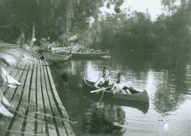
Photograph - Canoeing at Macauley's Boathouse, 1950s
Macauley's boat sheds (aka Kew Boatsheds) was located on the river at the western end of Molesworth Street, Kew.Black and white enlargement. Two children pictured in a canoe at Macauley's Boathouse on the River Yarra at Studley Park.Reverse: "Macauley's Boatsheds / M Holmes"boathouses -- river yarra, boathouses -- kew, macauley's boat shed, recreation -- canoeing