Showing 1552 items matching " aerial photographs"
-
 Port Melbourne Historical & Preservation Society
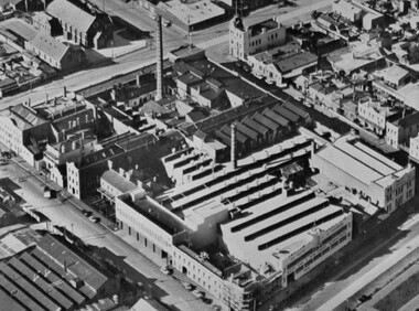
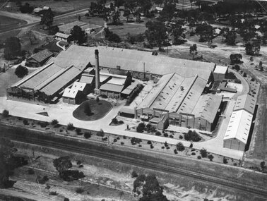
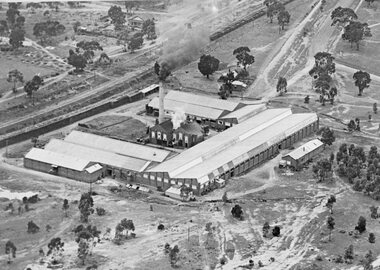
Photograph - Aerial view of Swallow and Ariell factory, Port Melbourne, c. 1950
... building visible on right hand side of photo Photograph Aerial view ...The Sandridge Marine Lodge was founded in 1858. Two locations; originally Stokes St and then in Liardet St from 1917. Both buildings are now converted to apartments. .03 - Aerial photo of Swallow and Ariell factory, with Stokes St Lodge building visible on right hand side of photobuilt environment - civic, built environment - domestic, societies clubs unions and other organisations, built environment - industrial, freemasons lodge, swallow & ariell ltd, sandridge marine lodge -
 National Vietnam Veterans Museum (NVVM)
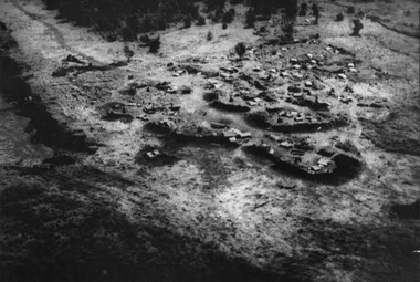
Photograph, Gibbons, Denis, Nui Thai Van Hills FSB
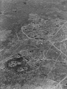
... A black and white photograph of an oblique aerial view... A black and white photograph of an oblique aerial view ...Denis Gibbons (1937 – 2011) Trained with the Australian Army, before travelling to Vietnam in January 1966, Denis stayed with the 1st Australian Task Force in Nui Dat working as a photographer. For almost five years Gibbons toured with nine Australian infantry battalions, posting compelling war images from within many combat zones before being flown out in late November 1970 after sustaining injuries. The images held within the National Vietnam Veterans Museum make up the Gibbons Collection. A black and white photograph of an oblique aerial view of an Australian Fire Support Base at the base of the Nui Thai Van Hills. The FSB provided a battalions direct artillery and mortar support, when on operation away from 1st Australian Task Force Base at Nui Dat, Phuoc Tuy Province. (circa May 1969)photograph, fire support base, 1st atf base, nui thai van hills, gibbons collection catalogue, artillery, mortar, nui dat, phuoc tuy province, denis gibbons -
 Charlton Golden Grains Museum Inc
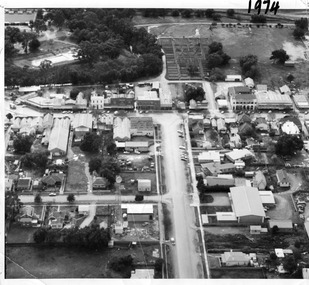
Photograph, Aerial photo of Armstrong St, Charlton, c.1974
Aerial photo looking down Armstrong St. Camp street on the left, Shire Hall on the right. High St runs across the photo. The Avoca River is visible in the top LH side. The swimming pool and bowling green is above the rive. On High St (from L-R) Dr Surgery, H Bath Chemist, Grocery, Roy Dobson, Hairdresser, Stowe's, Westpac Bank (two storey white building), Dillon's Building, Globe Hotel, Charlton Club, butcher shop, Arundell's shoe shop, Watson's Stock & Station Agency, Bullock's grocery, Williams St (Curtin Ave), Bannon's Butchers, East Charlton Hotel, MB Luth & Co, Lou's cafe. The old sale yards are at the end of Williams Street. Camp St lower side (from L-R) Court House, Police residence, Police Station, Telecom on corner. The photo is thought to be taken from Ossie Sanderson's airplane in 1974.Black & white aerial photo looking down a broad street that ends in a t-intersection. There is a street that comes off to the left about 1/3 of the way up the photo. There is a large building directly opposite this street. In the upper right there is a two storey building with arches on its verandah. In the upper LH side there is a swimming pool and bowling greens.armstrong st charlton, charlton, business, industry, westpac bank, globe hotel, east charlton hotel, dillon building -
 Bendigo Historical Society Inc.
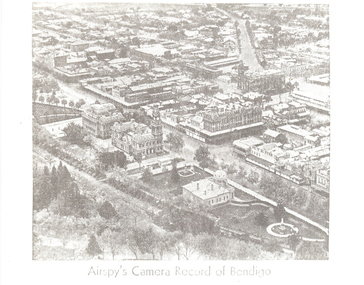
Photograph - AERIAL VIEW: BENDIGO, Approx. 1935
... in foreground, looking north east. Photograph AERIAL VIEW: BENDIGO ...BHS Collectionblack and white photo ( from newspaper /): aerial view of Bendigo City Centre, Post Office and Shamrock Hotel. Rosalind Park in foreground, looking north east.Airspy ?place, aerial view of bendigo -
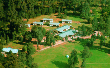 Marysville & District Historical Society
Photograph (Item) - Colour photograph, Unknown
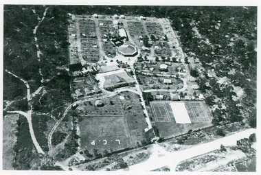
... A colour photograph of an aerial view of the lodges...A colour photograph of an aerial view of the lodges...A colour photograph of an aerial view of the lodges ...A colour photograph of an aerial view of the lodges at the E.S.A. Camping and Conference Centre in Marysville.A colour photograph of an aerial view of the lodges at the E.S.A. Camping and Conference Centre in Marysville.marysville, victoria, australia, e.s.a. camping and conference centre, photograph -
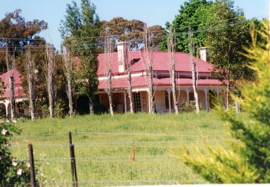 Stawell Historical Society Inc
Photograph, “MORAY” Residence on Crowlands Road Stawell
Residence - “MORAY” Crowlands Road Stawell3 photos 1 black and white 2 colour of house Moray on Landsborugh Rd Stawell-2 Moray Stawell 1985. Aerial View.stawell -
 Moorabbin Air Museum
Photograph (Item) - Includes, Lancaster, aerial photo of warships manoeuvring, mosquito, warships Wisconsin, Indomitable, victorious. Boeing 747 manufacturing plant. B47, B17, Smithsonian institute? F3 Demon. Photo showing various sections of an unidentified ship, Various photographs
... Various photographs Photograph Includes, Lancaster, aerial ... -
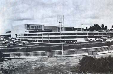 Greensborough Historical Society
Photograph - Photograph - Digital Image, The Valley Voice, Greensborough Centre 1979, 24/01/1979
A view of the newly completed (1979) Greensborough Centre (now called Greensborough Plaza). Shows the exterior KMart sign and multi storey car park. Also an aerial view of the complex. Several photographs of the central area.Digital copy of newspaper articlegreensborough plaza, kmart greensborough -
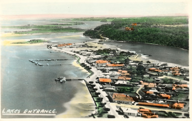 Lakes Entrance Historical Society
Photograph - Lakes Entrance, 1945c
... Aerial Photograph... Aerial Photograph Waterways Township Lakes Entrance Black ...Two tinted copies, one 8.5 x 13.5 and one 6.5 x 9Black and white postcard showing town, twelve memorial cypress trees and spotting tower on foreshore, post office wharf, boat harbour, Club Hotel at west end of esplanade with five palm trees opposite, causeway to Bullock Island, highway bridge over North Arm, highway up to Jemmys Point, Rigby, Fraser and Flannagan Island's towards Metung. Lakes Entrance VictoriaLakes Entrance islands, aerial photograph, waterways, township -
 Lakes Entrance Historical Society
Photograph - Lakes Entrance, 1997c
Colour print of aerial view looking south of western side of township. Shows housing on Kalimna Hill, North Arm, part of Bullock Island, Cunninghame Arm, the outer barrier and east pier of man made entrance. Lakes Entrance Victoriawaterways, township -
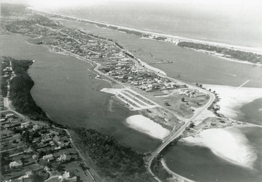 Lakes Entrance Historical Society
Photograph - Lakes Entrance, 1975c
... Aerial Photograph...Black and white photograph of an aerial view of township...Aerial Photograph Topography Township Black and white ...Black and white photograph of an aerial view of township and Kalimna Heights, showing the North Arm bridge and boat ramp, sand buildup in the lake system, boat harbour, sand hummocks and beach as far as Red Bluff. Lakes Entrance Victoriaaerial photograph, topography, township -
Stawell Historical Society Inc
Photograph, Aerial Photos of Stawell from a Hot Air Balloon 1992 -- 12 Photos
... stawell Series of 12 colour photographs from the Air. Aerial ...Series of 12 Aerial Photos of Stawell. Hot Air Balloon, October 1992 1. Cnr. Maude St & Grant Street 2. Maude St Napier Street & Railway cutting 3. Trotting Track 4. Roundabout Wimmera & Sloane Street 5. Florence Street towards Cato Lake & Park 6. Grampians Range with Lake Lonsdale near center 7. Gold Reef Mall looking West 8. Church Street looking West 9. Looking towards Black Range 10. Moonie Dams Darlington Road Leisure Complex 11. Stawell Gold Mine Evaporations Dams, Stawell Water Reservoirs, Moonie Dams 12. Darlington Road looking towards Black RangeSeries of 12 colour photographs from the Air.stawell -
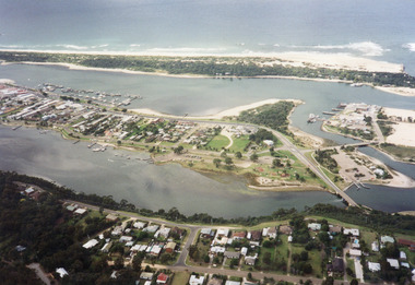
 Lakes Entrance Historical Society
Photograph - Lakes Entrance, 1997
... Aerial Photograph...Colour photograph being an aerial view of the western end...Date made 7 July 1997 Topography Waterways Aerial ...Date made 7 July 1997Colour photograph being an aerial view of the western end of Cunninghame Arm, showing the entrance between the hummocks, Bullock Island, entrance to North Arm, Snake Island surrounded by sand build-up. Lakes Entrance Victoriatopography, waterways, aerial photograph, boats and boating, township, islands -
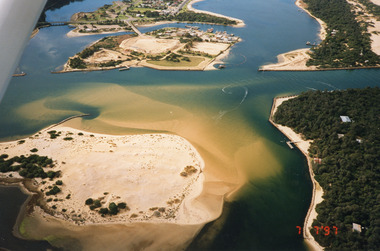 Lakes Entrance Historical Society
Photograph - Lakes Entrance, 1997
... Colour photograph being an aerial view of entrance at Lakes... Colour photograph being an aerial view of entrance at Lakes ...Date made 7 July 1997Colour photograph being an aerial view of entrance at Lakes Entrance, showing the sand hummocks, the sand bar offshore a fishing boat entering the channel through the bar which appears to be recently dredged township of Lakes Entrance Victoria waterways, islands, boats and boating -
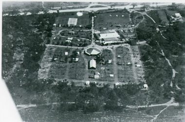 Lakes Entrance Historical Society
Photograph - Whiter's Camp Park, Bulmer H D, 1935
... Aerial Photograph...Tourism Resort Aerial Photograph Camping Black and white ...Black and white aerial view of Whiters Camp Park, looking south to Roadknight Street. Shows layout of camping facilities, including sites, tennis courts, rotunda, and family home which incorporated shop with all requirements for a holiday. Lakes Entrance Victoriatourism, resort, aerial photograph, camping -
 Lakes Entrance Historical Society
Photograph - Whiter's Camp Park, Bulmer H D, 1935
Black and white aerial view of Whiters Camp Park, looking north from Roadknight Street, showing layout of park including tennis courts, bowling green, picnic area, cottages, rotunda, and the family residence. Lakes Entrance Victoria tourism, camping -
 Falls Creek Historical Society
Photograph - Aerial View of Bogong Alpine Village
... Alpine Village Photograph Aerial View of Bogong Alpine Village ...The images in the Bogong Village Collection were displayed in Bogong Jack’s Tavern for over 20 years and were donated to the Falls Creek Museum when the Tavern closed in 2021. In 1939, the State Electricity Commission of Victoria established a field headquarters at Bogong to house workers and their families for the Kiewa Hydroelectric Scheme which ran from the 1930s to the 1960s. The workmen's camp was originally started with tents and was called Junction Camp. By 1947, the village supported 300 workers and their families. It included 40 houses, a hostel for single staff, a post office, a police station, a medical centre, and a primary school. The staff hostel was known as Kiewa House. At the completion of the Scheme, in the 1960s, the village was opened to public/tourism use. In 1968 the Victorian Education Department acquired the camp buildings and four houses from the State Electricity Commission of Victoria to establish an Outdoor Education Centre which operated for over 50 years. The Kiewa Hydroelectric Scheme was privatized in the 1990s and sold to Southern Hydro, before being acquired by AGL in 2005. In 2023 the Grollo Group signed a 73 year sublease on Bogong Village and has plans for its redevelopment as a workers’ village.These images are significant because they capture the development of Bogong Village as an important element of the Kiewa Hydroelectric Scheme in Victoria.An aerial view of Bogong Village and surrounds, date unknown.bogong alpine village, bogong high plains, aerial photos bogong village -
 Stawell Historical Society Inc
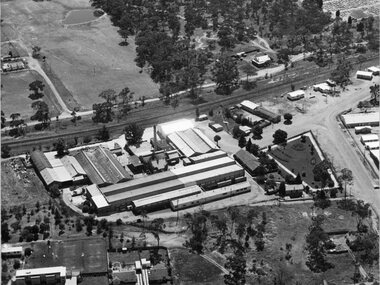
Photograph, North Western Woollen Mills with the Rail line in foreground -- Aerial View
... line in foreground -- Aerial View Photograph ...North Western Woollen Mills Aerial View. Rail line in foregroundstawell industry -
 Stawell Historical Society Inc
Photograph, North Western Woollen Mills -- Aerial View
... North Western Woollen Mills -- Aerial View Photograph ...North Western Woollen Mills Aerial Viewstawell industry -
 Stawell Historical Society Inc
Photograph, North Western Woollen Mills -- Aerial View
... North Western Woollen Mills -- Aerial View Photograph ...North Western Woollen Mills Aerial Viewstawell industry -
 National Vietnam Veterans Museum (NVVM)
Photograph, Gibbons, Denis, Fire Support Base Harrison
... A black and white photograph of an oblique aerial view... A black and white photograph of an oblique aerial view ...Denis Gibbons (1937 – 2011) Trained with the Australian Army, before travelling to Vietnam in January 1966, Denis stayed with the 1st Australian Task Force in Nui Dat working as a photographer. For almost five years Gibbons toured with nine Australian infantry battalions, posting compelling war images from within many combat zones before being flown out in late November 1970 after sustaining injuries. The images held within the National Vietnam Veterans Museum make up the Gibbons Collection.A black and white photograph of an oblique aerial view of the Australian Fire Support Base Harrison, Operation Pinnaroo. The FSB provided a battalions direct artillery and mortar support, to the infantry, on operations away from 1st ATF at Nui Dat, Phuoc Tuy Province. (Circa March 1968)photograph, fire support base harrison, operation pinaroo, 1st atf base, nui dat, phuoc tuy province, denis gibbons, gibbons collection, fsb harrison -
 Bendigo Military Museum
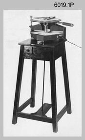
photograph - Royal Australian Survey Corps Aero-triangulation Equipment, 1936 to 1952
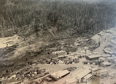
Although it’s unknown when these two photos were taken, the South African Pattern Mk IV Slotted Template Machine was in service from 1936 to 1952. The machine was used to cut slots and holes in an acetate film medium. This template was then used to fit several runs of aerial photography to ground control points at a desired scale with a substitution of the templates in the assembly. Radial slots on the templates from central holes representing the photograph’s principal point (centre) were placed over hollow metal studs mounted over control points on the scaled base sheet. The studs represented the intersection of radial lines through common points of detail of overlapping photos. A pricker was used to transfer from the photo-points to the templates. The slotted template methodology was later used as an essential aero-triangulation exercise in advance courses conducted at the School of Military Survey.These three photographs are of a slotted template machine used in aero-triangulation. The first two photographs were printed on photographic paper and are part of the Army Survey Regiment’s Collection. The photographs were scanned at 300 dpi. The third photograph was captured from a collection using a smart phone. .1) and .2) - Photo, black & white, 1936-1952. South African Pattern Mk IV Slotted Template Machine. .3) - Photo, black & white, 1936-1952. WO2 Bob Pratt operating the Slotted Template Machine. .1 and .2 –annotated on back “Slotted Template” .3P - annotated on front “COMPILATION SECTION SLOTTED TEMPLATE MACHINE WO2 BOB PRATT”royal australian survey corps, rasvy, army survey regiment, army svy regt, fortuna, asr, air survey, aerotrig -
 Bendigo Military Museum
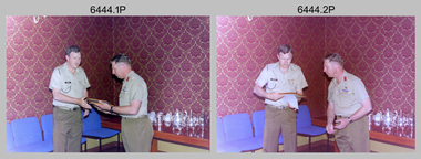
Photograph - Commander 3rd Military District Visit – Army Survey Regiment Fortuna, Bendigo, 1989
This is a set of 16 photographs of a visit to the Army Survey Regiment, Fortuna, Bendigo by the Commander 3rd Military District BRIG P. Davies AM, ADC on the 23rd and 24th of October 1989. In this set BRIG P. Davies AM, ADC was taken on a tour through the orthophoto production area. In photos .1P to .3P and .6P BRIG P. Davies AM, ADC presented a productivity award to CO LTCOL John Winzar in Fortuna’s Ballroom. LTCOL Winzar was the CO of the Army Survey Regiment from 1987 to 1989. The WILD OR1 orthophoto projector and workstation featuring in photos .7P to.10P and .12P to .14P was introduced in the mid-1980s. It was the second-generation equipment used to orthorectify colour and monochrome film aerial photography, replacing the system introduced in 1973. See items 6124.5P, 6133.4P and 6228.4P for more photographs of orthorectification equipment. Photos .15P and .16P feature contractors preparing the foundations for the construction of Lithographic Squadron’s new Printing Building at Fortuna, Bendigo. The building was purpose built to house a new computer-controlled Heidelberg Speedmaster five colour lithographic offset Printing Press. The print room was named Wayzgoose Hall after a medieval printing house festival. See item 6131.18P for more photographs of contractors preparing the foundations. This is a set of 16 photographs of a visit to the Army Survey Regiment, Fortuna, Bendigo by the Commander 3rd Military District (CMDR 3MD ) BRIG P. Davies AM, ADC on the 23rd and 24th of October 1989. The photographs are on 35mm negative film and were scanned at 96 dpi. They are part of the Army Survey Regiment’s Collection. .1) to .3) - Photo, colour, 1989. L to R: CO LTCOL John Winzar, CMDR 3MD BRIG P. Davies AM, ADC. .4) - Photo, colour, 1989. L to R: SGT Chris Edwards, CMDR 3MD BRIG P. Davies AM, ADC, SGT Graham Johnston, unidentified, SGT Martin Evans. .5) - Photo, colour, 1989. L to R: WO1 Allan Adsett, WO2 Keith Fenton RE UK Exchange, SGT Bob Garritty, WO2 Rob Bogumil, SSGT Peter Imeson, WO1 Ralph Chant. .6) - Photo, colour, 1989. L to R: CO LTCOL John Winzar, WO2 Pat Lumsden, SSGT Di Chalmers. .7) - Photo, colour, 1989. L to R: MAJ Terry Edwards, CMDR 3MD BRIG P. Davies AM, ADC, CPL Graeme Priestley, WO2 Rob Bogumil, SGT Bob Garritty. .8) - Photo, colour, 1989. L to R: CMDR 3MD BRIG P. Davies AM, ADC, CPL Graeme Priestley, SGT Bob Garritty. .9) & .10) - Photo, colour, 1989. L to R: CPL Trevor King, CMDR 3MD BRIG P. Davies AM, ADC, MAJ Terry Edwards. .11) - Photo, colour, 1989. L to R: ADJT CAPT Greg Tolcher, unidentified. .12) - Photo, colour, 1989. CPL Pat Drury, WILD OR-1 Orthorectification Workstation. .13) & .14) - Photo, colour, 1989. CPL Pat Drury, WILD OR-1 Orthorectification Workstation equipment. .15) & .16) - Photo, colour, 1989. Contractors prepare the foundations for Lithographic Squadron’s new Printing Building - Wayzgoose Hall..1P to .16P – no annotations. CMDR 3MD BRIG P. Davies AM, ADC and the date are identified on the film negative sleeve cover sheet.royal australian survey corps, rasvy, army survey regiment, army svy regt, fortuna, asr, litho sqn -
 Bendigo Military Museum
Photograph - RA Svy Project C4 Aerodist Operation, Eastern Arnhem Land, NT, 1967
This is a set of 30 photographs of Royal Australian Survey Corps (RA Svy) personnel from Central Comd Fd Svy Unit (Adelaide) on Aerodist survey operation - Project C4 in Eastern Arnhem Land, Northern Territory in 1967. Photos of personnel were taken either at the operations base at Numbulwar or the main base at Gove (Nhulunbuy). RA Svy conducted nineteen Aerodist operations for 12 years from 1964 to 1975. Aerodist MRC2 was a tellurometer-based system adapted for aircraft to accurately measure distances between non-intervisible ground survey stations, using the aircraft as an intermediate station. Lower order geodetic results could be achieved by survey network trilateration. The measured distances between stations formed survey networks from which each station’s latitude and longitude was computed. Aerodist MRC2 was RA Svy’s major horizontal control survey tool for mainly medium scale topographic mapping (scale 1:100,000 Class A being spatially accurate to within 50 metres) in PNG, northern NT, north-west WA, Kalimantan Barat (West) Indonesia, Sumatra Indonesia, Gulf of Carpentaria and Cape York, QLD. In 1967, the Aerodist MRC2 Master equipment was installed in the aircraft featured in this set of photos, Executive Air Services’ (Essendon VIC) Grand Aero Commander VH-EXX. It was the same aircraft type and company contracted to Division of National Mapping for Aerodist MRC2 surveys. From July to October 1967 the aircraft was attached to Central Comd Fd Svy Unit (Adelaide - Major Don Ridge) on Project C4 eastern-Arnhem Land NT, where 317 Aerodist lines measuring 17,300 line miles were successfully completed. This was the most productive Aerodist project thus far. The most common helicopter used by RA Svy up to 1972 was the civilian Bell 47G-2 and the Sioux Light Observation Helicopters (LOH), the Australian Army’s equivalent featured in this photo set. These light observation helicopters had a limiting load carrying capacity of up to about 500 pounds. By comparison, one Aerodist team including two people weighed up to 1,500 pounds. Source: Royal Australian Survey Corps – Aerodist Years 1964-1975 by Peter Jensen. This is a set of 30 photographs of Royal Australian Survey Corps (RA Svy) personnel on Aerodist survey operations in Eastern Arnhem Land, Northern Territory in 1967. The photographs are on 35mm negative film and scanned at 96 dpi. They are part of the Army Survey Regiment’s Collection. .1) to .4) - black & white, 20th August 1967, Project C4 Aerodist Operations Base - Numbulwar, NT. .5) - Photo, black & white, 1967. Probable wrecked Indonesian fishing vessel. .6) to .8) - Photo, black & white, 1967. Unidentified survey operations base, L to R: unidentified personnel. .9) - Photo, black & white, 1967. Unidentified survey operations base, unidentified soldier driving a Haflinger 4x4 Light utility vehicle. .10) - Photo, black & white, 1967. Unidentified survey operations base, L to R: unidentified technician. .11) - Unidentified technician reading two survey altimeters to compute corrections to the measured distances for atmospheric refraction and to compute the sea level distances from the slope distances aircraft to the ground stations. .12) - Photo, black & white, 1967. Unidentified survey operations base, L to R: unidentified personnel. .13) to .16) - Photo, black & white, 1967. Unidentified personnel operating remote Aerodist MRC2 ground instruments. .17) to .18) - Photo, black & white, 1967. Unknown RA Svy office location. .19) to .20) - Photo, black & white, 1967. Aerodist MRC2 Master equipment. .21) to .22) - Photo, black & white, 1967. Aero Commander VH-EXX probably at Gove, NT, Central Comd Fd Svy Unit (Adelaide) – OC Major Don Ridge. .23) to .25) - Photo, black & white, 1967. Aero Commander VH-EXX probably at Gove, NT. Unidentified personnel. .26) - Photo, black & white, 1967. Aero Commander VH-EXX probably at Gove, NT. Aerodist antenna pods are visible on the aircraft. .27) to .29) - Photo, black & white, 1967. Australian Army Sioux Light Observation Helicopter (LOH) probably at Gove, NT. .30) - Photo, black & white, 1967. Panelled U337 survey station, visible as a white cross on aerial identification photo..1P to .2P – date and location on edge of film negative. .5P to .28P – no annotations .29P - annotated in white ‘RW-JEP Gove NT’ .30P - annotated in white ‘U337 Spool No1 Jun67’royal australian survey corps, rasvy, army survey regiment, army svy regt, fortuna, asr, aerodist, surveying, central comd fd svy unit -
 Bendigo Military Museum
Photograph - KLIMSCH Large Format Camera and Wild OR1 Orthorectification Equipment - Army Survey Regiment, Fortuna, Bendigo, c1986
The main tasks undertaken by technicians operating the KLIMSCH Commodore large format camera were enlargements and reductions of map reproduction material. seen in photo .1P is at the operating console. See item 6189.4P for more information and photos of CPL Whaling operating the KLIMSCH camera. Orthophoto mapping provided the Survey Corps with the capability to produce map products quickly in the event of a crisis. These are four photographs of equipment used by the Army Survey Regiment to produce orthophotomaps. The WILD OR1 orthophoto projector and workstation shown in photos .3P and .4P was introduced in the mid-1980s. It was the second-generation equipment used to orthorectify colour and monochrome film aerial photography, replacing the system introduced in 1973. See items 6124.5P and 6133.4P for more photographs of orthorectification equipment.These four photographs of KLIMSCH large format camera and Wild OR1 orthorectification equipment was taken at the Army Survey Regiment at Fortuna, Bendigo, c1986. The colour photographs are on 35mm negative film and scanned at 96 dpi. They are part of the Army Survey Regiment’s Collection. .1) - Photo, colour, c1986, CPL John Whaling operating the KLIMSCH Camera. .2) - Photo, colour, c1986, large format film developer. .3) - Photo, colour, c1986, WILD OR-1 Orthorectification Workstation operated by CPL Dave Jobe. .4) - Photo, colour, c1986, WILD OR-1 Orthorectification Workstation..1P to .4P – There are no annotations.royal australian survey corps, rasvy, army survey regiment, army svy regt, fortuna, asr -
 Bendigo Military Museum
Photograph - Royal Australian Survey Corps - Map Production Processes, c1990
This is a collection of 20 photographs of Royal Australian Survey Corps phases of map production at the School of Military Survey, Bonegilla, the Army Survey Regiment, Bendigo, and the Army Map Depot, Bandiana circa 1990. Colour photos are on 35mm slide film and were scanned at 96 dpi. They are part of the Army Survey Regiment’s Collection. Photo .1P was probably taken on a survey station overlooking Lake Hume near Albury-Wodonga. The field party occupying the survey station was likely from a Map Control Survey course conducted by the School of Military Survey, Bonegilla. This survey station was part of a geodetic network used in field survey training and RASvy’s Lake Hume Test Range. Photos .3P to .16P were taken at the Army Survey Regiment, Bendigo and photos .17P & .18P were taken at the Army Map Depot, Bandiana. Photo .19P depicts a map of RASvy’s ARA units before the disbandment of 5th Field Survey Squadron, Perth and 2nd Field Survey Squadron, Sydney in 1990. This is a collection of 20 photographs of map production processes taken at the School of Military Survey, Bonegilla, the Army Survey Regiment, Bendigo, and the Army Map Depot, Bandiana circa 1990. Colour photos are on 35mm slide film and were scanned at 96 dpi. They are part of the Army Survey Regiment’s Collection. Photo .2P is printed on photographic and scanned at 300 dpi. .1) – Photo, colour, c1980s. Geodetic Surveying: AN/PRR-14 Geoceiver antenna on hill surrounding Lake Hume. Series 3 Land Rover, field party tent and survey station beacon in background. .2) – Photo, black & white, c1980s. Geodetic Surveying: AN/PRR-14 Geoceiver antennas set up at the School of Military Survey, Bonegilla, Victoria. .3) – Photo, colour, c1990. Aerotriangulation: Wild PUG4 point transfer device, SSGT Bruce Hammond. .4) – Photo, colour, c1990. Aerotriangulation: Zeiss (Jena) Stecometer, SSGT Bruce Hammond. .5) – Photo, colour, c1990. Aerotriangulation: computer tape maintenance, SSGT Noel McNamara. .6) – Photo, colour, c1990. AUTOMAP 2: computer tape maintenance, SPR Nadine (Paul) Read. .7) - Photo, colour, c1990s. AUTOMAP 2: Optronics 4040 scanning/film output in Lithographic Squadron, SGT Sherri (Dally) Burke. .8) - Photo, colour, c1990s. AUTOMAP 2: Benson verification plotter output, SPR Nadine (Paul) Read. .9) – Photo, colour, c1990. Aerotriangulation: data management, SGT Neil ‘Ned’ Kelly. .10) & .11) - Photo, colour, c1990s. AUTOMAP 2: Wild B8 Aviograph stereoplotter Feature Extraction, unidentified technician. .12) - Photo, colour, c1990s. AUTOMAP 2: Graphic Edit Workstation, SPR Nadine (Paul) Read. .13) - Photo, colour, c1990s. AUTOMAP 2: Graphic Edit Workstation, SPR Dawn Hoadley. .14) & .15) - Photo, colour, c1990s. AUTOMAP 2: Graphic Edit Workstation, unidentified technician. .16) – Photo, colour, c1990s. Heidelberg Speedmaster 102 computer-controlled five colour lithographic offset printing press. .17) & .18) – Photo, colour, c1990s. Army Map Depot, unidentified storeman, Bandiana. .19) – Photo, colour, c1990. RASvy ARA Unit Locations before disbandment of field units in Perth and Sydney. .20) – Photo, colour, c1990. Set of overlapping aerial photography..1P, .3P to .20P - Some equipment is identified on the frame of the 35mm slides.royal australian survey corps, rasvy, army survey regiment, army svy regt, fortuna, asr, school of military survey, army map depot -
Merbein District Historical Society
Photograph, Aerial view Merbein blocks & Murray River flood (framed), unknown
merbein township, murray river -
 Warrnambool and District Historical Society Inc.
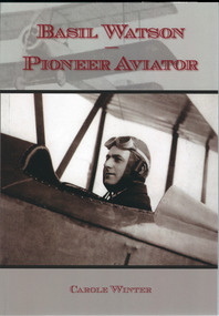
Book, Basil Watson Pioneer Aviator, March 2015
This book gives details on the life and work of Basil Watson (1893-1917), a pioneer aviator in AustraliaThis is a paper back book with a plastic-laminated cover. There are 61 pages with diagrams, photographs, illustrations, advertisements, posters and newspaper cuttings. The cover is mainly grey and white in colour with printed material in a red insert and two photographs superimposed over the background.This book gives details on the life and work of Basil Watson (1893-1917), a pioneer aviator in Australiabasil watson, warrnambool and aviation pioneer, australian aviators -
 Glenelg Shire Council Cultural Collection
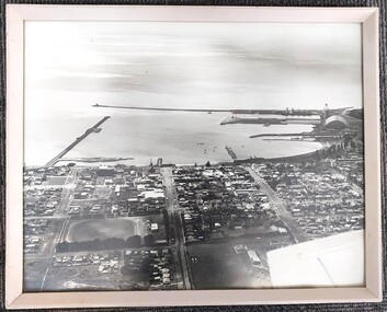
Photograph - Photograph - aerial view of Portland foreshore, 1970s
... Photograph - aerial view of Portland foreshore...Portland Foreshore harbour coastal photography Aerial Photo ...Aerial view of Portland and foreshore. Black and white photograph. Breakwater is on left, but part has only one domed building evident on far right.Front: (no inscriptions) Back: Twites Picture Framers, Carlton label.portland foreshore, harbour, coastal photography, aerial photo, portland -
 National Vietnam Veterans Museum (NVVM)
Photograph, Gibbons, Denis, Early Morning Check
Denis Gibbons (1937 – 2011) Trained with the Australian Army, before travelling to Vietnam in January 1966, Denis stayed with the 1st Australian Task Force in Nui Dat working as a photographer. For almost five years Gibbons toured with nine Australian infantry battalions, posting compelling war images from within many combat zones before being flown out in late November 1970 after sustaining injuries. The images held within the National Vietnam Veterans Museum make up the Gibbons Collection. A colour photograph of the Loadmaster on board an RAAF Caribou transport aircraft carrying out an early morning check, including washing the windscreen, prior to commencing the days alloted tasks. The Caribou's of 35 Squandron were Australia's aerial work horses in Vietnam.photograph, raaf, caribou, 35 squadron, gibbons collection catalogue, denis gibbons, photographer, vietnam war, loadmaster