Showing 1668 items
matching subdivisions
-
 Glen Eira Historical Society
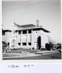
Article - ‘REPTON’, ELM AVENUE, 10, ELSTERNWICK
This file contains six items about this mansion: 1/Three pages of handwritten notes by Peta Darke, dated December 2013, concerning the title and ownership of Repton from 1881 till 2013, earlier called ‘Wahgunyah’ 2/Handwritten list of owners of Repton from various editions of Sands and McDougall Directories compiled by Peta Darke on 06/12/2013 3/Black-and-white photograph of exterior of Repton, undated, photographer unknown 4/Seven copies each of a classified advertisement in The Argus newspaper relating to Repton and its occupiers. Dates are 15/01/1927, 15/12/1928, 07/03/1917, 10/07/1926, 02/07/1940, 10/04/1944, and 28/01/1949 5/Article in Property Review Weekly dated 15/11/2013 advertising forthcoming auction on 30/11/2013. Includes colour photographs of exterior and interior. Also brochure real estate agent advertising forthcoming auction of Repton: includes 4 colour photographs of exterior and interior, description of property and plan of layout. Produced in 2013. 6/Printed information taken from 'Trove' regarding former residents of 'Repton', Elm Street, Elsternwick by Claire Barton. Research is from the Stubss family tree about Dermot Du Moulin Ryan whose mother's address is listed as this property.repton, wahgunyah, elm avenue, elm road, elsternwick, roan andrew, partridge john douglas, partridge alice anna, partridge john roland phelps, phillips ida mary charlotte, steers reuben rivers, mann agnes, gruer william frank, taylor james alexander, marmaras george, marmaras arthur, supported housing, stevens edward, matthews herbert, repton court flats, marmara drive, lehte, fosbery avenue, taylor florence ethel, wood john frances wealth, brick houses, land subdivision, flats, victorian style, stubbs family, ryan dermot du moulin, ryan kate, elm street, house names, ryan h h -
 Glen Eira Historical Society
Article - KOOYONG ROAD, 230, CAULFIELD NORTH, ‘SANQUHAR’
This file contains two items about this property: 1/One page of handwritten research notes, compiled by Claire Barton, about a property located at 230 Kooyong Road, Caulfield North, known as ‘Sanquhar’. Barton acquired the information therein from two sources. The first source – an article from the Argus, dated 13/06/1956, accessed via Trove on 27/08/2013, and titled ‘Old Caulfield Landmark to be Cut Up for Homes’ – notes that the property is to be subdivided into 34 individual lots. The second source – the 1923 and 1942 editions of Sands & McDougall – list the persons dwelling at the property during these years. There exists a discrepancy between these two sources. The article from the Argus implies that the property was not divided until 1956. The 1942 edition of Sands & McDougall, however, implies that it was already subdivided by this date. 2/A printout of the aforementioned article from the Argus itself, again accessed via Trove, this time on 20/06/2014.‘sanquhar’, mansions, kooyong road, glen eira road, caulfield north, barton claire, slatter kate mrs, petterson carl m., petterson e. g. miss, brown jno g., goldsack w. c., robertson j.d., cypress trees, robert harper and co. ltd., robert harper & co. ltd., abercromby & beatty pty. ltd., abercromby and beatty pty. ltd., anderson & hickling, land subdivision, bell family, bell hugh j., padey e.g., jaynes gwen, caulfield city council, anderson and hickling -
 Federation University Historical Collection
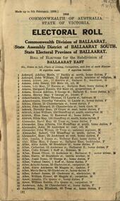
Booklet, W.M. Housten, Governent Printer, Commonwealth Division of Ballaarat. State Assembly District of Ballarat South. State Electrical Province of Ballaarat. Role of Electors for the Subdivision of Ballarat East, 1958, 1958
Ballarat East Electoral Rollelectoral roll, ballarat east, w.m. housten -
 Ringwood and District Historical Society
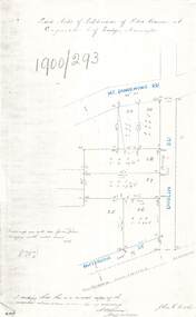
Document - Copy of Lands Department Field Notes - Subdivision of Police Reserve at Ringwood, County of Mornington, Field Notes 1900/293 - Part of O.P. R72C surveyed 1900
Foolscap size photocopy of survey map with handwritten notations. References include Mount Dandenong Road, Dublin Road, Patterson Street, Melbourne to Lilydale railway line, I certify that this is a correct copy of recorded observations made by my assistant (signed) W. Thorn, Staff Surveyor. -
 Ringwood and District Historical Society
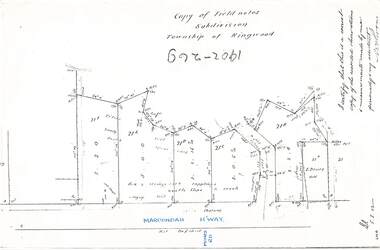
Document - Copy of Lands Department Field Notes - Subdivision Township of Ringwood, Victoria, Field Notes 1902/269 - Part of O.P. R72D surveyed in 1902
Foolscap size photocopy of survey map with handwritten notations. References include Maroondah Highway, (opposite) Mines Road, Ti tree, Sandy soil, heath, spear grass, box & stringy bark sapplings, gentle slope to creek, E. Drury. I certify that this is a correct copy of the recorded observations and measurements made by me personally and my assistant (signed) W. Thorn. -
 Ringwood and District Historical Society
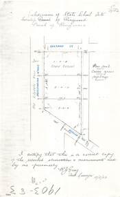
Document - Copy of Lands Department Field Notes - Subdivision of State School Site, Township of Ringwood, Victoria, Field Notes 1903/83 - Part of O.P. R72C Surveyed 13/2/1903
Foolscap size photocopy of survey map with handwritten notations. References include Everard Street, Old Lilydale Road (Maroondah Highway), Dublin Road, poor soil, coarse grass, saplings, I certify that this is a correct copy of the recorded observations & measurements made by me personally (signed) R.J. Gray Autorised Surveyor 13/2/03. -
 Ringwood and District Historical Society
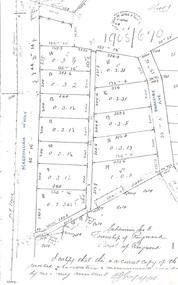
Document - Copy of Lands Department Field Notes - Subdivision of Ringwood, Victoria, Field Notes 1904/188 - Part of O.P. R72D Surveyed 28.4.1904
Foolscap size photocopy of survey map with handwritten notations. References include Mount Dandenong Road to Lilydale, M. Dickson (sold), Church of England, P. Schonnenberger, Helen Lindsay, W.B. iron roof & shingles, I certify that this is a correct copy of the recorded observations and measurement made by me and my assistant (signed) W. Thorn 12/5/04 -
 Ringwood and District Historical Society
Document - Copy of Lands Department Field Notes - Subdivision Sec E, Township of Ringwood, Victoria, Field Notes 1908/670 - Survey O.P. R72E dated November 1908
Foolscap size photocopies of survey maps with handwritten notations. -
 Ringwood and District Historical Society
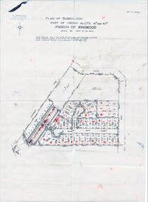
Map, Plan of Subdivision Parish of Ringwood, Victoria - c.1960
Black and white photocopied plan - Part of Crown Allotments 14A and 40A showing blocks in Sharps Court and Salsibury Court, Heathmont. Some blocks showing sale price.K.J. Noonan & Co. Licensed Land Surveyors, Suite 16 "Gloucester Lodge", 445 StKilda Road, Melbourne S.C.2, Telephone BM 1631. References to coloured easements etc., not evident from b&w photocopy. -
 Ringwood and District Historical Society
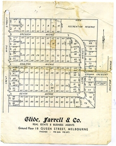
Document, Glen Turnbull, Land Sale Brochure - Heathmont Hills Estate - subdivision of Stan Wieland's Land (undated), 25/2/2008
Small brochure by Glide Farrell & Co, real estate and Business Agents, Melbourne advertising "93 Superb Building Blocks 3Mins Station & Shops", and "Sky-Line Views of Heathmont Hills Estate" , comprising lots in Dresden Ave, Doulton Ave, Devon Ave, Viviana Crescent, Leoni Avenue. -
Ringwood and District Historical Society
Legal record - Conditions of Sale (C.E.Carter), Ringwood - Lot 3, Plan of Subdivision No 11956, Mrs S Corrie to Holeproof Ltd, 1944
Particulars and Conditions of Sale of Property , from Mrs S Corrie to Holeproof Ltd. Register No 11956. -
Ringwood and District Historical Society
Legal record - Conditions of Sale (C.E.Carter), Ringwood - Lot 6, Plan of Subdivision No 4433573, Mrs.R.E.Green to Mr.J.J.Toner, 1947
Particulars and Conditions of Sale of Property , from Mrs.R.E.Green to Mr.J.J.Toner. -
Ringwood and District Historical Society
Legal record - Conditions of Sale (C.E.Carter), Ringwood - Lot 8, Plan of Subdivision No 14010, C.E.Carter (Agent) to Frank W.McKinnon, 1942
Particulars and Conditions of Sale of Property , from C.E.Carter (Agent) to Frank W.McKinnon. -
Ringwood and District Historical Society
Legal record - Conditions of Sale (C.E.Carter), Ringwood - Lot 13, Plan of Subdivision No 7346, C.E.Carter (Agent) to Herbert Williams, 1935
Particulars and Conditions of Sale of Property , from C.E.Carter (Agent for ES & A Bank) to Herbert Williams -
Ringwood and District Historical Society
Legal record - Conditions of Sale (C.E.Carter), Ringwood - Lot 2, Plan of Subdivision No 12622, C.E.Carter (Agent for William Cross) to Ernest O'Keefe, 1937
Particulars and Conditions of Sale of Property , from C.E.Carter (Agent for William Cross) to Ernest O'Keefe. -
Ringwood and District Historical Society
Legal record - Conditions of Sale (C.E.Carter), Ringwood - Lot 7, Plan of Subdivision No 7522 , C.E.Carter (Agent for E.D.Chung) to E.F.Hounslow, 1940
Particulars and Conditions of Sale of Property , from C.E.Carter (Agent for E.D.Chung) to E.F.Hounslow - Register No 7522. -
Ringwood and District Historical Society
Legal record - Conditions of Sale (C.E.Carter), Ringwood , Lot 136 of Subdivision 10506, Mrs F.E.Western to Mrs M.E.Robbie, 1945
Particulars and Conditions of Sale of Property , from Mrs F.E.Western to Mrs M.E.Robbie. -
Ringwood and District Historical Society
Legal record - Conditions of Sale (C.E.Carter), Ringwood , Lot 4 of Subdivision 11645, Mr H.E.Watson and Mr J.F.McIntyre, 1945
Particulars and Conditions of Sale of Property , from Mr H.E.Watson to Mr J.F.McIntyre. -
Ringwood and District Historical Society
Legal record - Conditions of Sale (C.E.Carter), Ringwood , Lot 11 on Plan of Subdivision No 7522, Mr C.Wilson to Annie Mary Campbell, 1940
Particulars and Conditions of Sale of Property , from Mr C.Wilson to Annie Mary Campbell. -
Ringwood and District Historical Society
Legal record - Conditions of Sale (C.E.Carter), Ringwood , Lot 10 & 11 on Plan of Subdivision No 5117, Mr T.H.Warwick to Mr O.A.Frederick, 1947
Particulars and Conditions of Sale of Property , from Mr T.H.Warwick to Mr O.A.Frederick. -
Ringwood and District Historical Society
Legal record - Conditions of Sale (C.E.Carter), Ringwood , Lot 3 on Plan of Subdivision No 3916441, Mr W. Ballock to Mr & Mrs Bott circa 1943
Particulars and Conditions of Sale of Property , from Mr W.Ballock to Mr & Mrs Bott. -
Ringwood and District Historical Society
Legal record - Conditions of Sale (C.E.Carter), Tunstall , Lot 62 on Plan of Subdivision 10994, C.E.Carter ( Estate of Bridget Kelly) to Miss F.M.Sharp, 1943
Particulars and Conditions of Sale of Property , from C.E.Carter ( Estate of Bridget Kelly) to Miss F.M.Sharp. -
Ringwood and District Historical Society
Legal record - Conditions of Sale (C.E.Carter), Ringwood , Lot 29 on Plan of Subdivision 8198, Draft Contract for Mr C.J.Martin, Circa 1940
Particulars and Conditions of Sale of Property , Draft Contract for Mr C.J.Martin. -
Ringwood and District Historical Society
Legal record - Conditions of Sale (C.E.Carter), Ringwood , Lot 4 on Plan of Subdivision 6629, Mr C.H.Rayner and Mrs A.Guy, 1924
Particulars and Conditions of Sale of Property , from Mr C.H.Rayner to Mrs A Guy. -
Ringwood and District Historical Society
Legal record - Conditions of Sale (C.E.Carter), Ringwood , Lot 5 on Plan of Subdivision 9648, Mr A.H.Loche to Mr C.F.Osmond, 1944
Particulars and Conditions of Sale of Property , from Mr A.H.Loche to Mr C.F.Osmond. -
Ringwood and District Historical Society
Legal record - Conditions of Sale (C.E.Carter), Ringwood , Lot (?) on Plan of Subdivision (?), Mrs F.L.Coombes to Mr R.A.Bonsack, 1945
Particulars and Conditions of Sale of Property , from Mrs F.L.Coombes to Mr R.A.Bonsack. -
Ringwood and District Historical Society
Legal record - Conditions of Sale (C.E.Carter), Ringwood , Lot 12 on Plan of Subdivision 2216, Falconer Bros to Mr G.K.Gibson, 1943
Particulars and Conditions of Sale of Property , from Falconer Bros to Mr G.K.Gibson. -
Ringwood and District Historical Society
Legal record - Conditions of Sale (C.E.Carter), Ringwood , Lot 57 on Plan of Subdivision 8198, Mr E.R.Givers to Mr C.N.Wilson, 1940
Particulars and Conditions of Sale of Property , from Mr E.R.Givers to Mr C.N.Wilson. -
Ringwood and District Historical Society
Legal record - Conditions of Sale (C.E.Carter), Ringwood , Lot 19 on Plan of Subdivision 8198, Mrs E.M.Wright to Mr C.J.Peglar, Circa 1940
Particulars and Conditions of Sale of Property , from Mrs E.M.Wright to Mr C.J.Peglar. -
Ringwood and District Historical Society
Legal record - Conditions of Sale (C.E.Carter), Ringwood , Lot 3 on Plan of Subdivision 10519, Mrs S.H.Houston to Mr J.J.Constable, Circa 1940
Particulars and Conditions of Sale of Property , from Mrs S.H.Houston to Mr J.J.Constable.