Showing 28811 items
matching 5/6
-
 Ballarat Tramway Museum
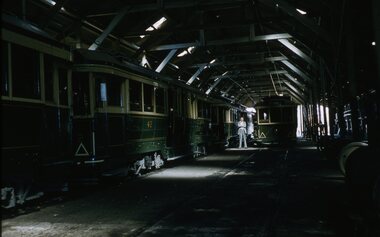
Slide - 35mm slide/s, Ben Parle, 5/04/1958 12:00:00 AM
Kodachrome Transparency - 35mm slide - cardboard mount, with one side with red border and words "Kodachrome Transparency / Processed by Kodak" top and bottom. Photo taken by Ben Parle 5/4/1958. Has slide No. "6" stamped in red in top corner and date stamped on slide. Photo of interior of Wendouree Parade depot - with bogie and single truck trams. Tram 42 on left hand side of slide. Friend of Ben Parle standing alongside a single trucker. For high resolution scan see btm2836h.tif"Depot" "-5 APR 1958"tramways, trams, wendouree parade, depot, ballarat depot, tram 42 -
 Phillip Island and District Historical Society Inc.
Photograph, 20th Century
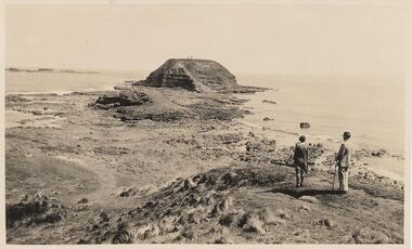
Selection of 6 photographs and postcards of The Nobbies, A Seal and the SS Killara, donated by D Reid.A selection of postcards and photograph Black & White and Coloured of The Nobbies, a Seal and the SS Killara. Photo 1. View of the Nobbies with two people in the foreground. Photo 2. View of the Nobbies with a Horse and jinker in the foreground. Photo 3. A Seal resting on the rocks at Seal Rocks Phillip Island Photo 4. The Ferry steamer S. S. Killara arriving at Cowes Photo 5. Coloured view of the Nobbies looking across breakers on the rocks. Photo 6. Coloured coastal view looking towards the Nobbies in the distance.Inscriptions on the front of postcards Photo 2. The Rose Series. P 666. Looking to The Nobbies, Phillip Island, Victoria Photo 3. The Rose Series. P 747. A Seal on the rocks, Phillip Island, Victoria Photo 4. The Ferry Steamer S. S. "Killara" arrives at Cowes. Photo 5. The Nobbies, Cowes Photo 6. Coastal Scene Cowes. Nobbies in Distance.the nobbies phillip island, wildlife - seals, seal at seal rocks, ss killara, ferries -
 Bendigo Military Museum
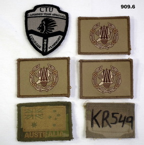
Uniform - ARM PATCHES, c.2001-2016
Items related to Shai NOKES Australian Army colour patches .1) CTU Combined Team Uruzgan patch. Black & white featuring a lion's head & motto, shield shaped. .2), .3) & .4) Unit insignia patches. Khaki rectangle with embroidered logo centred in wreath in cream, gold & brown. .5) Australia flag patch KR 549. Green & gold central map of Australia. All above have over sewn edges. .6) KR549. Khaki rectangle with handwriting..1) Motto: “Courage Unity Teamwork” .5) Embroidered under map: “AUSTRALIA” .6) Handwritten in texta: KR549 uniforms - army, badges, patches -
 Wodonga & District Historical Society Inc
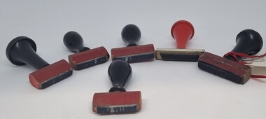
Functional object - Railway Station stamps Cudgewa Line
Cudgewa Line -The Cudgewa railway line opened in stages between 1889 and 1921. The first section from Wodonga to Huon opened on 10 September 1889. It was extended to Bolga on 18 July 1890, Tallangatta on 24 July 1891 and then to Shelley on 13 June 1916. Shelley was the highest station in Victoria. It extended further on to Beetomba on 10 April 1919 and finally reached Cudgewa on 5 May 1921. The line had 1 in 30 grades and trestle bridges that have been heritage listed. In 1919, the line was used to carry materials for the construction of Hume Weir, and three years later a spur line connecting Ebden to the weir was opened. In the 1960s, Cudgewa became the railhead of materials for the Snowy Mountains Scheme. The last passenger service from Wodonga to Tallangatta ran on 30 September 1961. The turntable and passenger platform at Cudgewa were abolished in 1976.6 Rubber and wood stamps used in the stations along the Cudgewa Line. The stamps were primarily used to acknowledge receipt of small freight items carried on the Cudgewa LineOn individual stamps: 1. TALLANGATTA 1476 2. BULLIOH 1477 3. BEETOOMBA 1484 4. KOETONG 1480 5. SHELLEY 1482 6. CORRYONG 1487cudgewa rail line, victorian railways, closed victorian railways -
 Coal Creek Community Park & Museum
Equipment - Weights
From Manning Chemist, Flinders Street Railway Station, Melbourne. Described as 'old' by Mr. Manning.Apothecary weights. In measurements of 'grains'. Weights for 1, 3, 4, 5 and 6 grains. Each weight is in the shape of the number of grains it weighs. Thin metal plates. All marking on the front.6 grains, marked on the front: 6 GRAINS G67 F61 E63 G65 C57 (crown)CA5 VIC J54 D59 5 grains, marked on the front: 5 GRAINS (crown) CA5 VIC J54 F61 E63 G67 C57 G65 D59 4 grains, marked on the front: 4 GRAINS C57 D59 (crown) CA5 VIC J54 F61 G65 E63 G67 3 grains, marked on the front: 3 GRAINS F61 J54 (crown) F61 G65 E63 G67 1 grain, marked on the front: 1GR C57 (crown) J54 -
 The 5th/6th Battalion Royal Victoria Regiment Historical Collection
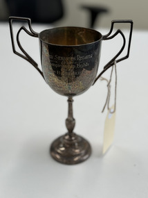
Award - Trophy, United Services Regatta 1938 Championship Eights, 1938
Rowing trophy won in 1938 by anticedent unit of 5/6 RVRSmall, Art deco silver trophy with two, double tiered handles on long ornate stem. Engraved on obverse United Services Regatta 1938\Championship Eights Won By 6th Battalion Bow CPL M Stokoe 2 Pte M.J. Fakhry 3.Pte D.B.Tudehope. 4. Capt H.E. Wright 5. Pte T.D. Nuendorf 6.Pte k.q. nUENDORF 7.Pte H. Gunnerson Str Sgt F.F. Knowles Cox Capt H.E. Comporl Coach Capt T.F.Davies6th battalion, interwar, trophy, rowing -
 Flagstaff Hill Maritime Museum and Village
Domestic object - Iron
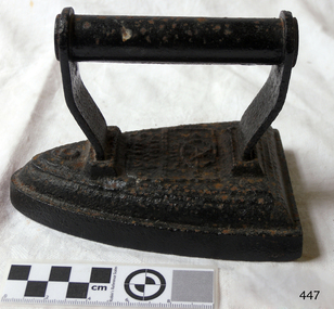
Before the introduction of electricity, irons were heated by combustion, either in a fire or with some internal arrangement. An "electric flatiron" was invented by American Henry Seely White and patented on June 6, 1882. It weighed almost 15 pounds (6.8 kg) and took a long time to heat. The UK Electricity Association is reported to have said that an electric iron with a carbon arc appeared in France in 1880, but this is considered doubtful. Two of the oldest sorts of iron were either containers filled with a burning substance, or solid lumps of metal which could be heated directly. Metal pans filled with hot coals were used for smoothing fabrics in China in the 1st century BC. A later design consisted of an iron box which could be filled with hot coals, which had to be periodically aerated by attaching a bellows. In the late nineteenth and early twentieth centuries, there were many irons in use that were heated by fuels such as kerosene, ethanol, whale oil, natural gas, carbide gas (acetylene, as with carbide lamps), or even gasoline. Some houses were equipped with a system of pipes for distributing natural gas or carbide gas to different rooms in order to operate appliances such as irons, in addition to lights. Despite the risk of fire, liquid-fuel irons were sold in U.S. rural areas up through World War II. In Kerala in India, burning coconut shells were used instead of charcoal, as they have a similar heating capacity. This method is still in use as a backup device, since power outages are frequent. Other box irons had heated metal inserts instead of hot coals. From the 17th century, sadirons or sad irons (from Middle English "sad", meaning "solid", used in English through the 1800s[4]) began to be used. They were thick slabs of cast iron, triangular and with a handle, heated in a fire or on a stove. These were also called flat irons. A laundry worker would employ a cluster of solid irons that were heated from a single source: As the iron currently in use cooled down, it could be quickly replaced by a hot one. https://en.wikipedia.org/wiki/Clothes_ironThis iron is typical of the clothes iron used before electric irons superseded it.Salter iron no. 6, painted black but with rust showing through. Salter iron no. 6.flagstaff hill, warrnambool, shipwrecked-coast, flagstaff-hill, flagstaff-hill-maritime-museum, maritime-museum, shipwreck-coast, flagstaff-hill-maritime-village, iron, clothes, laundry -
 Surrey Hills Historical Society Collection
Photograph, Surrey Hills Mounted Police Station (Dem.)
Surrey Hills Mounted Police Station was located at 5 Suffolk Road (dem.) from 1889-1914. It was a police residence with two rooms as the police office and workshop. There were stables on the back fence. The property adjoined Wyclif Church in Norfolk Road. Gilbert McCallum rented from c.1914-1923 when he built a home in Westminster Street. It is his son Archie who can just be seen on the front steps. Archie remembers the 2 storied stables with a gantry for hauling feed sacks up with a block and tackle, then a polished wood slide to send the feed down. The McCallum children and local friends found this to be a marvellous slide. David McPhie, ex-police force, lived here with his family from 1923-c.1950. A black and white photograph showing a mid to late Victorian style weatherboard house with decorative brackets under the eaves. The verandah is of timber with decorative timber fretwork.surrey hills mounted police, suffolk road, surrey hills, wyclif church, (mr) gilbert mccallum, (mr) david mcphie, police, (master) archie mccallum -
 Ballarat Tramway Museum
Negative, Travis Jeffrey, 5/08/1962 12:00:00 AM
Colour Negative No. N403, of Bendigo Birney No. 11, outbound to Golden Square at Honeysuckle St. Loop?, has a mile post oppose the front of the tram. Tram has the destination of Golden Square. Photo possibly 17/6/1962. Colour laser printed copy of image stored in box 73. Original negative hires scan and image updated 28/5/2020.In red pen on folder that contained negative, "NR91B" and "5 Aug 62". trams, tramways, bendigo, golden square, honeysuckle st., tram 11 -
 Royal Australian and New Zealand College of Obstetricians & Gynaecologists (RANZCOG)
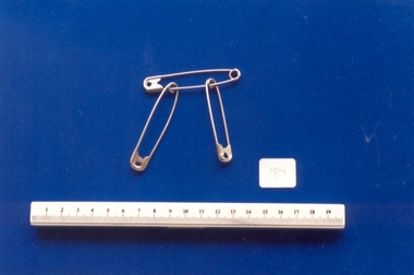
Domestic object - Safety pins used by Dr Mitchell Henry O'Sullivan, c. 1930-1960
These type of safety pins were commonly used in hospitals between 1930- 1960. Pins such as these were advertised for sale as "Hospital and Sick Room Sundries" and were generally supplied in boxes of 12 dozen (144). The pins were supplied in sizes ranging from 0 to 6 - the pins catalogued here are sizes 4,5, and 6. Dr Mitchell Henry O'Sullivan worked in the Victorian country town of Casterton as a general practitioner from 1919 until his death in 1977. He also practiced obstetrics. His son, Dr David More O'Sullivan donated his obstetric bag and its contents to the College in 1999. The bag and contents are a unique time capsule of the type of instruments and pharmaceuticals used in the inter-war period.Three nickel plated safety pins (.1 - .3) of differing sizes. .1 is size 4, .2 is size 5, and .3 is size 6. -
 Eltham District Historical Society Inc
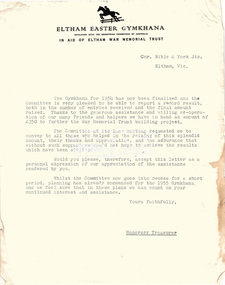
Folder, Eltham War Memorial Trust; Easter Gymkhana Committee Minutes, 19 Nov 1954-6 Jun 1958
Contents: Notice from Honoury Treasurer of Easter Gymkhana Committee regarding completion of 1954 event and expression of thanks and that committee is now going into recess prior to commencement of planning for 1955 Notice of Easter Gymkhana Committee Meeting, Monday 24th October, 1955 at the Shire Hall, Eltham Letter from B.T. Taylor, Hon. Secretary, Eltham Easter Show Committee regarding the sale of tickets (c.1957) Letter from B.T. Taylor, President, Eltham Easter Show Committee to Georges Ltd regarding the supply of The Georges Cup for the Eltham Easter Show, 11 April 1958 Letter from Georges Ltd to B.T. Taylor, President, Eltham Easter Show Committee with payment for the minitiares of The Georges Cup, 6 June 1958 Letter from Eltham Shire Secretary to B.T. Taylor, President, Eltham Easter Show Committee advising of new procxess regarding raffle, 5 May 1958 Letter from Lilian Heath, Secretary, Judge Book Village Auxiallary to B.T. Taylor, Eltham Easter Show Committee, 24 May 1958 Letter from Mrs R.J. Godfrey on behalf of M.A. Godfrey of Dandenong to B.T. Taylor, President, Eltham Easter Show under threat of legal action requesting replacement of cheque for £10 (second prize Open Jumping Contest), which was lost, 24 May 1958 Reply by B.T. Taylor, President, Eltham Easter Show Committee to Mrs R.J. Godfrey to her letter of 24 May explaining circumstances and denying responsibility to forward a replacement cheque as it was cashed at the Golf Club Hotel; 6 June 1958 History of the War Memorial Following the end of the First World War, communities across Victoria and Australia typically erected memorials which were predominantly statues, cenotaphs, avenues of honour and plaques. The Shire of Eltham established the Avenue of Honour at the gateway to the shire as well as an obelisk at the corner of Main Road and Bridge street and the Shire of Eltham War Memorial Tower at Kangaroo Ground. After the Second World War communities once again desired to preserve the memories of those who served and paid the ultimate sacrifice. Resources were scarce so there was a transition away from the traditional style memorials that sprang up post 1918 to one of building facilities that would provide ongoing benefit to the community. Even before the end of the Second World War, the citizens of Eltham began to consider an appropriate form of memorial for those from the area who fought and died in the First and Second World Wars. In 1943 the Eltham Women’s Auxiliary raised funds for the construction of buildings to be established on land to be purchased for the proposed War Memorial. On March 27th, 1945, the Eltham District Progress Association called a meeting of local people who in turn set up and registered the Eltham War Memorial Trust Inc. As a focus for the purpose of the memorial, the newspaper notice read:- ‘Those who have had a member of their family in the fighting services will want to see that the form of a memorial we are concerned with is the one which will be a constant reminder to us of those who fought for us and the little ones for whom they fought and died.’ At that meeting it was decided the Memorial should take the form of a baby health centre along with a creche and children’s library. In late 1945, the newly formed Eltham War Memorial Trust purchased the land at 903-907 Main Road Eltham from Miss Shillinglaw, which once formed part of the Shillinglaw farm on Lot 90 of Holloway’s 1851 “Little Eltham” subdivision. The Governor of Victoria, General Sir Dallas Brooks, laid the foundation stone on November 24th, 1950, in memory of those who fell in the Second World War. The Eltham Infant Welfare Centre was opened November 15th, 1952, the Pre-school on December 1st, 1956, and the Children’s Library in 1961. In late 1966 the children’s library service was integrated into the Heideberg Regional Library Service and the building was officially renamed the Eltham War Memorial Hall. Following the opening of the Eltham Infant Welfare Centre, work began in 1953 planning for the entrance to the grounds, which is signaled by a wrought iron arch entitled “Eltham War Memorial” . In 1954 the Eltham War Memorial Trust decided that a legacy provided by the late Councillor Ernest James Andrew (d. 29 March 1950) in memory of his wife, Mrs. Ellen Andrew (d. 13 July 1946) and who are both buried at Eltham Cemetery, should be used to fund the construction of the entrance. A metal plate inscribed to this effect was attached to the gates. Work on the Memorial Gardens was undertaken throughout the following decade, with a Memorial Forecourt included in the final 1956 plans for the Pre-School Centre. A quote was accepted by the Trust in 1963 for the implementation of a memorial garden, which included grading of a sixty-five foot strip at the rear of the Trust buildings and construction of concrete paths. The stone retaining walls at the front of the site were installed in 1968 when Main Road was widened and it is believed that the Memorial Gates were relocated at that time also. Eltham Senior Citizens Centre In 1964, Eltham Shire Council purchased a section of land from the Trust at the northern end of the site, as a provision for Country Fire Authority buildings. At the same time the Elderly Citizens Club proposed a Senior Citizens Centre on the south western section of the Trust’s property. This was approved by the Trust with the provision that the building was constructed in ‘accord’ with those already existing. In 1965 Council took on board the plans for the Senior Citizens Centre and applied for a government grant. These could only be awarded if Council owned the site. In 1962 the Trust had resolved to hand over the assets to Council once the Memorial Gardens were completed. This was in line with Health Department requirements that grants for the ongoing operation and maintenance of the three facilities would only be made once the the facilities were completed and handed over to Council. In 1965 the Department of Health further demanded substantial alterations to the Pre-School playground as a result of the pending impact of the planned Senior Citizens Centre and Main Road duplication. As a consequence, handover of the Trust’s assets to Council was initiated with a formal ceremony held in the Children’s Library on August 28th, 1965. The Trust continued on as a committee of management for another twelve months. Plans and specifications for the Senior Citizens Centre were prepared by March 1966. Council obtained a grant from the Government which covered one third of the cost and the building was completed by April 1967. Whilst the Senior Citizens Centre is contained within the original Eltham War Memorial building precinct, it was not part of the original Memorial and was not funded by the Eltham War Memorial Trust.Nine copies of letters/notices inserted loose in Minute Book, 33 x 21 x 1 cm, green faux crocodile skin hard board end-covers with black spine binding; 82 pages (last 38 blank)b.t. (ben) taylor, easter gymkhana committee, eltham war memorial trust, georges ltd, golf club hotel, judge book village auxilliary, lilian heath, minutes, r.j. godfrey, the georges cup -
 Ballarat Tramway Museum
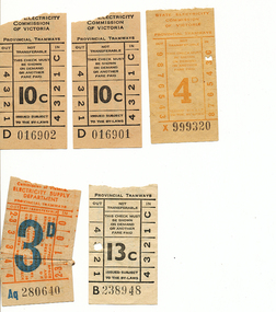
Ephemera - Ticket/s, State Electricity Commission of Victoria (SECV), Set of 5 SEC tickets, 1950's to 1970
Demonstrates ticket printing and usage and has a strong association with the donor.Set of 5 SEC tickets. 1 - 3d - Aq 280640 - off white paper, light red printed ticket with price and letters in blue and the ticket number in black. Has a Bushells Pty Ltd advert on rear for a free booklet "How to read tea cups". 2 - 4d - X999320 - off white paper, with printing in brown and the ticket number in black. Has a brown lined back. 3 - Two (2) No.10c tickets, office white paper with printing in black - numbers D0116901 and D016902. Has a SEC "Electricity makes life easier" ad on rear. 4 - 13c ticket - B238948, off white paper with black printing - with a SEC "Electricity makes life easier" ad on rear and a hand written notation about its use - used on 21/8/1971, last day of Victoria St operation. last ticket See also Reg Items 259, 1950, 3464, 6140, 6977 for other "last tickets". on rear of 4, "Ballarat 21/8/71, last day of Victoria St line operation" in blue ink.trams, tramways, tickets, closure, victoria st -
 Ballarat Tramway Museum
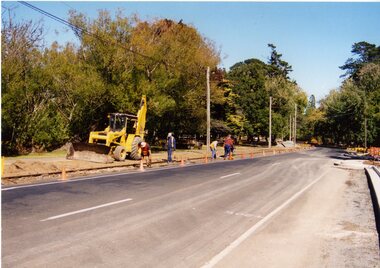
Photograph - Colour Print/s - set of 5, Warren Doubleday, 5 and 6/4/2003/
Set of five colour photographs of the repair of northern end of Wendouree Parade. Photos taken on 5 and 6/4/2003, printed on AGFA paper. 2557.1 - The general scene with the new kerb and channel on the north side - backfilling around the sleepers 5/4/03. 2557.2 - Packing between the sleepers, Len Millar, Sam Boon and Richard Gilbert 5/4/03. 2557.3 - Welding track bonds - Paul Mong 6/4/03 2557.4 - Packing the broken joint area - Simon Green, Alan Snowball, Gary Wood, Bryan Hill, Paul Mong and Peter Winspur with No. 8 in the background. 6/4/03. 2557.5 - Testing the track with No. 8 - Garry Wood and Sam Boon.trackwork, wendouree parade, track, tram 8 -
 Glen Eira Historical Society
Album - Album page, Munster Avenue, Circa 1972
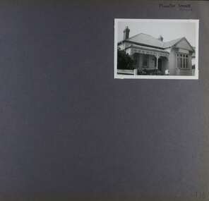
This photograph is part of the Caulfield Historical Album 1972. This album was created in approximately 1972 as part of a project by the Caulfield Historical Society to assist in identifying buildings worthy of preservation. The album is related to a Survey the Caulfield Historical Society developed in collaboration with the National Trust of Australia (Victoria) and Caulfield City Council to identify historic buildings within the City of Caulfield that warranted the protection of a National Trust Classification. Principal photographer thought to be Trevor Hart, member of Caulfield Historical Society. Most photographs were taken between 1966-1972 with a small number of photographs being older and from unknown sources. All photographs are black and white except where stated, with 386 photographs over 198 pages. This house continues to occupy the property at 5 Munster Avenue Carnegie (Google map image capture Feb 2019).Page 136 of Photograph Album with one landscape photograph of an Edwardian house on Munster Avenue.Handwritten: Munster Street / Avenue [top right] / 136 [bottom right]trevor hart, garden, verandah, bull nosed verandah, edwardian, coloured glass, corrugated iron roof, bay window, gable, chimneys, porch, munster avenue, carnegie, box bay window, weatherboards, cast iron work, timber houses -
Glen Eira Historical Society
Article - Cosy Gum Road, 5, Carnegie
Three real estate ads of different sizes for this property with varying photos, all relating to the auction on 06/08/2011: 1/ An undated article from the Melbourne Weekly regarding the auction of the house at 5 Cosy Gum Road, Carnegie to be held 06/08. The article describes details and features of the house. It includes three colour photographs. 2/ Ad dated 13/17/2011 from the Melbourne Weekly Bayside - Your Community Voice with a full page colour photo of the front exterior plus one of the rear exterior, one of the living / dining room and one of the billiards room. 3/ Ad dated 03/08/2011 from the Melbourne Weekly Bayside - Your Community Voice with large colour photo of front exterior plus living / dining room plus kitchen interior photos.house, auctions, cosy gum road, carnegie -
 Marysville & District Historical Society
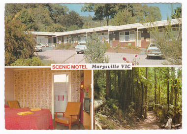
Postcard (item) - Colour postcard, R. Bell, SCENIC MOTEL Marysville VIC, Unknown
A colour postcard of the Scenic Motel in Marysville. The postcard was produced by Bellevue Color Views Australia as a souvenir of Marysville.A colour postcard of the Scenic Motel in Marysville. The postcard was produced by Bellevue Color Views Australia as a souvenir of Marysville.Produced/ and/ Printed/ in/ Australia Bellevue Color Views Australia Colour photography by R. Bell/ Box 37, Ormond Vic. SCENIC MOTEL/ 5 DARWIN STREET,/ MARYSVILLE, VICTORIA, 3779/ Phone: (059) 633 247 "The little Motel with the big view" Quite location, all facilities, Barbeque,/ parking at door, moderate tariff, personal/ attention from your hosts. BV 366marysville, victoria, australia, scenic motel, accommodation, postcard, souvenir, bellevue color views australia, r. bell -
 Marysville & District Historical Society
Postcard (item) - Colour postcard, R. Bell, SCENIC MOTEL Marysville VIC, Unknown
A colour postcard of the Scenic Motel in Marysville. The postcard was produced by Bellevue Color Views Australia as a souvenir of Marysville.A colour postcard of the Scenic Motel in Marysville. The postcard was produced by Bellevue Color Views Australia as a souvenir of Marysville.Produced/ and/ Printed/ in/ Australia Bellevue Color Views Australia Colour photography by R. Bell/ Box 37, Ormond Vic. SCENIC MOTEL/ 5 DARWIN STREET,/ MARYSVILLE, VICTORIA, 3779/ Phone: (059) 633 247 "The little Motel with the big view" Quite location, all facilities, Barbeque,/ parking at door, moderate tariff, personal/ attention from your hosts. BV 366marysville, victoria, australia, scenic motel, accommodation, postcard, souvenir, bellevue color views australia, r. bell -
 Falls Creek Historical Society
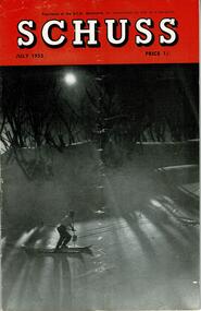
Journal - Schuss Vol. 19. No. 5 July 1953
Schuss was advertised as Victoria’s Official Ski Journal It was issued monthly from 1935 to 1961 except during the war when summer issues covered two months. This continued after the war, but it averaged 10 issues annually over its 25 year life. Schuss was published by the Ski Club of Victoria which had a membership of 38 Ski Clubs and demanded to be recognised as the prime authority on skiing in the state. The other 30 ski clubs with 85% of the members disagreed and the politics of skiing became heated. These clubs formed the Federation of Victorian Ski Clubs with their own journal, Ski Horizon. With the establishment of the Victorian Ski Association, Ski-Horizon published its last issue in Nov - Dec. 1955 and the role of the official journal was fully taken over by “Schuss”. This item is significant because it contains stories, images and information documenting the development of the ski industry in Victoria.The journal features stories and events chronicling developments in Victoria and internationally. Items related to the Falls Creek Area in this issue include:- Page 153 - an advertisement for ski lessons, tours and accommodation for skiers with Bob Hymans. A second advertisement for Pearce Bros., General Merchants at Tawonga stated they could arrange for food supplies for clubs or ski parties to be delivered into lodges at city prices. Page 168 feature a photo by H. Gibbs - On the road to Falls Creek, beyond Howman's Gap, showing slopes of of Spion Kopje in the background. Page 177 - The Galleon Ski Club had opened its books to a limited number of Associate Members and offered its Members use of the "GALLEON" Lodge. Associate Membership fee was set at £1/1/- per annum. Lodge fees were 12/6 per day per member. Page 182 announced ALBURY Ski Club's Annual Ball will be held this year on November 28th. The event promised to live up to the reputation of the previous year's very happy "do" at Toonallook Woolshed, and it should be worth going a long way to be in it, even to devoting the whole weekend to a visit. Note the date now.schuss journal, bob hymans, h. gibbs photos, galleon ski club, albury ski club -
 Melbourne Legacy
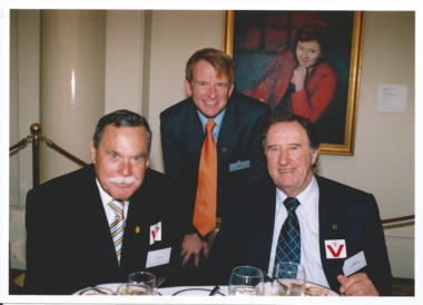
Photograph - Legacy Appeal 2005, Parliament House Event, 2005
A Legacy function at Queens Hall, Parliament House, Melbourne. Geoff Webb is president and Ron Barassi is a guest. More photos at 00735. 00734.1 Ron Barassi with two others. 00734.2 Unknown lady with John So (Lord Mayor of Melbourne 2001-2008). 00734.3 President Geoff Ward with x and David Cull. 00734.4 Four elderly legatees with a young man (from left, Harold Ramsay, Trevor Parker, unknown and Dave Worrall). 00734.5 Ron Barassi with the young man and x. 00734.6 A large group with Ron Barassi, including Dulcie Cedaro on left, Legatee Denise Millic, Ron Barassi, a junior legatee, Bert Dennis (a former JL), Legatee Larraine Shea, plus two othersA record of a function for Legatees. Colour photo x 6 of guests at a Legacy function.Printing on the back "legatee event, legacy promotion, ron barassi -
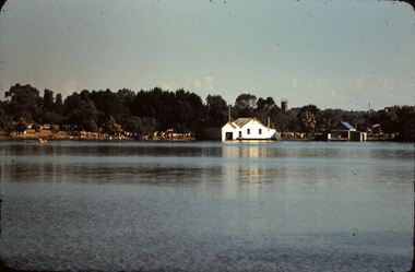 Bendigo Historical Society Inc.
Slide - FLEMING COLLECTION: 1950S BENDIGO SLIDE, 5 June 1958
Bendigo 1950s. Lake Weeroona 5/6/1958. Bendigo Rowing Club buildings.buildings, organisation, bendigo rowing club, lake weeroona 5/6/1958. bendigo rowing club buildings. -
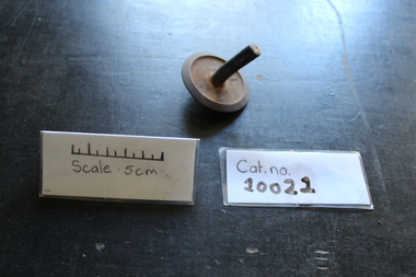 Coal Creek Community Park & Museum
5 Gram Weight
Rounded Bent handle 5 Inscriped on it Rusty5 -
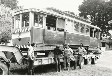 Ballarat Tramway Museum
Photograph - Black & White Photograph/s, The Courier Ballarat, 5/12/1983 12:00:00 AM
Yields information about the arrival back in Ballarat of No. 13 from Lake Goldsmith, prior to unloading.Black and White copy photograph of a newspaper photograph taken by The Courier of No. 13 unloaded at BTM depot (left-right) Peter Winspur, Garry Wood, Peter Allen, Warren Doubleday. Photo taken 5/12/1983, published 6/12/1983. See Reg Item 825 for the newspaper clipping the photograph was used in and further details.. Collected by Alan Bradley from the Ballarat Courier early 1980's. See Excel file "Record of Ballarat Courier Photos BTM era" (Archive Documents) for source of details. .1 - Duplicate print of the same photograph.On rear stamped "Copyright, The Ballarat Courier Proprietary Limited." and a label with "Front cover, 6 5/8" x 4 1/2". .1 - stamped "Copyright, The Ballarat Courier Proprietary Limited." on rear.tramways, trams, tram recovery, 13, btps, tram 13 -
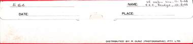 Ballarat Tramway Museum
Negative, Brian Andrews, Folder No. 64 - 35mm - SEC Bendigo and VR Western line, 12-5-1968
Contains part of the negatives that the photographer took of Bendigo and its tramway system on a 1968 visit. For the actual prints see the Album 8637 and the digital images held in the Museum's photo collections files. Many of the photographs were used in Brian's book, "By Birney to Golden Square" Includes as well 172 photographs of J and K class locomotives at the Ararat locomotive depot.Demonstrates the work of Brian Andrews.Negative folder - paper folder by R. Gunz (Photographic) Pty Ltd containing 6 strips of 35mm negatives in a plastic clear sleeve.Folder No. 64 - 35mm - SEC Bendigo 12-5-68 and VR Western line 11-5-1968trams, tramways, brian andrews, negatives, bendigo, ararat, steam locomotives, j class, k class -
 Ringwood and District Historical Society
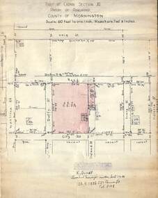
Document, 1926 Land Survey drawing of the area surrounding 1-5 City Road, Ringwood
Drawing on parchmentHand-drawn survey of what is now 1-5 City Road, Ringwood. Drawn by K Arndt, licensed surveyor, 237 Queen Street, Melbourne Tel 5118 on 25 September 1926. The block of land in question was 2 roods, 21 and 8/10 perches in size. The location was between Haig Street in the north, City Road in the south, Wantirna Road in the west and Victoria Road in the east. The Good Shepherd Retirement Village (Lutheran) now occupies the land. The drawing shows a number of existing weatherboard houses, fences and frontage sizes. A number of named roads were defined but no longer exist, these were Duffy Street (to the west), Evans Street (east) and Victoria Street (further east). Ireland Street still exists in the south. -
 Melbourne Tram Museum
Slide - Set of 7, Keith Caldwell, 22/03/1969 12:00:00 AM
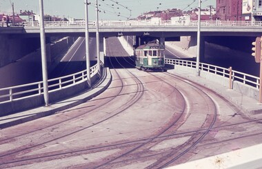
Set of seven Agfa colour slide, blue and white plastic mount, photo by Keith Caldwell on 22/3/1969 of the then new track work in Queensway St Kilda, closing the former track in Wellington St. .1 - W2 363 inbound, route 5 climbing the grade to the St Kilda Road Junction. Has the overpass in the background. .2 - W2 229 ditto .3 - W2 377 ditto waiting for another W2 5?6 crossing in front of the tram. .4 - SW6 941 outbound, route 5, Malvern Burke Road with advertisements for PGF golf clubs and Vodka Wyborowa. .5 - W2 421 outbound route 5. .6 - W2 347, East Brighton route 64 outbound in Queensway with the Windsor Fire Station and the former cable tram winding house (the big red building) in the background. .7 - A W2 inbound..1 and .6 has in pencil "22/3/1969".trams, tramways, st kilda rd, queensway, new tramway, route 5, east malvern, route 64, east brighton, w2 class, sw6 class, tram 363, tram 229, tram 377, tram 347, tram 421, tram 347, tram 941 -
 Bendigo Military Museum
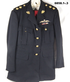
Uniform - MESS DRESS, OFFICERS, Snows, 1951
Refers to the service of "Lt. R. Baker" 5/13385..1) Jacket, black wool. Four front pockets. Rising Sun on Collars. Lieut. pips (2) on each epaulette. Four brass buttons on front. Button Motif - Australian Military Forces. On left chest are two ribbons, War medal 1939-45 and Australian Service Medal, and an RAAF Flying wings badge. .2) Trousers, black wool, Red stripe down outside of legs. Button fly, striped lining around waist line inside. Two side and one rear pocket. .3) Shirt - off white cotton, long sleeves, one breast pocket. .4) Cap - peaked black, red band, Rising Sun Badge. .5) Tie - black .6) .7) Shoes - pair of black leather, rubber soled shoes L & R.Inside jacket - “Lt. R. Baker 5/13385 2/11/51”ww2, post ww2, mess dress uniform, r. baker, passchendaele barracks trust -
 Eltham District Historical Society Inc
Photograph - Aerial Photograph, Landata, Eltham; Crown Allotment 15, Section 5, Parish of Nillumbik (Stokes Orchard Estate), Apr, 1963
Centred on present day Diosma Rd, Stokes Pl, Nyora Rd and Eucalyptus Rd Historic Aerial Imagery Source: Landata.vic.gov.au Aerial Photo Details: Project No :486 Project : MELBOURNE (1963) PROJECT Run : 6 Frame : 122 Date : 04/1963 Film Type : B/W Camera : RC8 Flying Height : 5100 Scale : 9600 Film Number : 1805 GDA2020 : 37°43'12"S, 145°09'32"E MGA2020 : 337723, 5823642 (55) Melways : 22 B6 (ed. 42) A History of the Development of Crown Allotment 15, Section 5, Parish of Nillumbik – Stokes Orchard Crown Allotment 15, Section 5, Parish of Nillumbik (CA15) is a square allotment of 158 acres or approximately a quarter of a square mile. It lies just beyond the eastern end of Pitt Street, south of Nyora Road to the northern end of Eucalyptus Road and extends east from Eucalyptus Road to Reynolds Road. The topography of CA15 is generally steep, sloping up to a hill near the centre of the land, the ridgeline passing through the properties along the southern side of Diosma Road. Eucalyptus Road is a straight north-south road with its northern end at the north west corner of CA15. Until the end of the 1970s this road was an un-named Government Road and was largely not open to traffic. With residential development in the 1970s the road was constructed, and the council allocated the name obviously in recognition of the predominant species of the local bushland. CA15 was purchased from the Crown by George D’Arley Boursiquot, a prominent Melbourne printer, on 28th October 1852. On November 23, 1922, former Member for Gippsland and Melbourne Real Estate Agent, Hubert Patrick Keogh purchased the allotment then sold it March 13, 1925, to local farmer, Robert David Taylor, a former Shire of Eltham Councillor (1911-1920) and Shire President (1919). Taylor had extensive land holdings stretching west towards Bible Street and Main Road. The Taylor home was situated at the top of the hill in Bible Street at present day 82 Bible Street. At the time of Taylor’s purchase in 1925, CA15 was subdivided into 48 lots that could be described as small rural properties or large residential lots. A typical lot size was one hectare or 2.5 acres. The subdivision created two roads, Nyora Road, and Diosma Road, each following an irregular alignment between Eucalyptus and Reynolds Roads. However, the lots were not sold off separately nor were the roads constructed. The land effectively remained as one parcel for many further years. Robert David Taylor died November 30, 1934, and probate was granted to his son of the same name, Robert David Taylor of Bible Street, Salesman and William McLelland Vance Taylor of 73 Emmeline Street, Northcote, Clerk, with the transfer of the land into their names on July 8, 1935. Frank Stokes worked as a qualified accountant at Kennons leather factory in Burnley, while living at 1 Thomas Street, Mitcham. He suffered from migraines and wanted to return to working the land (he had previously worked on farms and orchards since coming to Australia from England in 1926, both in WA and Vic.). He first travelled to the district by train in July 1942 to find land with the intention to establish an orchard. By chance he met Arthur Bird of Bird Orchard (bounded by Pitt Street, Eucalyptus Road, and Wattle Grove) and they got talking over their common interest. Arthur put Frank up for the night and pointed out the land, 158 acres- part of the Taylor Estate- £900, Crown Allotment 15, Section 5, Parish of Nillumbik (CA15) somewhat diagonally opposite Bird Orchard. Stokes applied through the Riverina Agency to purchase the land who in turn applied for permission from Canberra to sell as there was a new government regulation introduced during the Second World War banning land sales except for immediate production. Stokes obtained a loan on his Mitcham house of £600 @ 5% and paid £450 deposit with quarterly payments of £15 spread over 5 years. Stokes was assisted and advised by Arthur Bird who farmed the neighbouring orchard. In early 1943 Stokes took possession and would catch the train out to Eltham on Fridays after work and began building a hut on the corner of Nyora Road and the Government Road (Eucalyptus Road) for shelter and to lock up tools. He established an orchard on the central western part of the land through the centre of which ran a natural waterway (part of the present-day linear park) and was able to pay a neighbour (Hawkins) to help with clearing and fencing 25 acres, and with a horse and single furrowed plough, planted approximately 2,500 fruit trees - cherries, peaches, plums, almonds, pears, apricots and lemons as well as a few apples and oranges; a massive task. Aerial photographs from the 1940s through to the 1990s clearly show the orchard with most of the larger CA15 site remaining as natural bushland. A huge problem was hares and rabbits eating all the new buds off the tiny trees. As well as laying poison he painted the trees with a mixture of cow manure and lime, often working by moonlight. Procurement of wire and wire netting was difficult because of the war but after much effort he obtained a permit from the Agricultural Department for supplies in March 1944. In February 1945 Stokes applied for a permit to build a “packing shed” as no house building was allowed. It was to be 33 feet x 21 feet and cost £312. It was constructed mostly from second-hand materials, which were hard to obtain, especially iron for roofing. Stokes finished work at Kennons on October 31, 1945, and in March 1946 he sold the family home at Mitcham for £1,230 plus £170 for furniture. On May 15, 1946, title to the CA15 property was issued to Frank Howard Alfred Stokes, Orchardist and Gladys Ethel Stokes, Married Woman, both of Pitt Street, Eltham. The family of five then moved into the very unfinished “packing shed” at Eltham, which was a struggle to weatherproof. Eventually rooms were divided off and lined with hessian bags and whitewashed. Their income was firewood (cut and sold), selling rockery stones and cut Sweet Bursaria. (It was discovered during the 1940s that Sweet Bursaria contained the sunscreen compound Aesculin. The RAAF utilised this compound from Sweet Bursaria during WW2 for pilots and gunners.) The orchard’s first fruit sale was a half-case of Le Vanq peaches in December 1947 for the price of 8 shillings. In 1956 plans for house were drawn and Glen Iris bricks purchased (1956 Olympic Rings variant). The building of the house commenced in 1957 - 12 feet of original packing shed was removed – and was completed in 1959. Water was connected from newly built pressure storage on the property at the end of 1959 and the electricity connection for the first time at 3pm on April 29, 1960. The house remains to present day (somewhat modified) at 1 Nyora Road, home to Nyora Studio Gallery. On occasions, spare remnants of the 1956 bricks have been known to be unearthed in gardens on the estate as they were utilised by Frank Stokes to fill in rabbit holes. On May 26, 1950, a parcel of land was compulsorily acquired by the Melbourne and Metropolitan Board of Works on the hilltop to establish an easement for a high-level service reservoir to augment Eltham’s water supply. The project also included pipe tracks for the necessary water mains. The reservoir has now been superseded by higher level water tanks east of Reynolds Road and its former site is now a public reserve. On November 27, 1964, the State Electricity Commission served notice to compulsorily acquire a further parcel through the eastern part of the land for a major electricity transmission line that augmented supply from the La Trobe Valley to Melbourne. The easement was registered February 11, 1966. The easement was widened July 18, 1969 for a second transmission line to be constructed. In 1971 Melbourne Metropolitan Planning Scheme amendments adopted Nyora Road as the boundary between a residential zone to the north and a rural zone to the south. This determined the future development of the land. In the mid-1970s the Shire of Eltham divided the orchard into numerous rate-able parcel lots, the 48 lots having been established in 1925 and the subsequent rates assessment proved unsustainable for Stokes. He commenced selling lots outside the boundary of the orchard, north of Diosma and South of Nyora. However shortly later the land between Nyora and Diosma Roads and west of the electricity easement was sold and subdivided into residential lots, a housing development by Macquarie Builders and marketed as the Stokes Orchard Estate. New streets were created, and most were named after trees, although one, Stokes Place, commemorates the former owners. The development was undertaken in two stages; Stage 1 (1975) encompassing Scarlet Ash Court, Ironbark Close and Peppermint Grove bounded by Nyora and Eucalyptus roads and Stage 2 (1978) encompassing Stokes Place, Orchard Way, The Crest and The Lookout bound by Nyora and Diosma roads. The developer, Macquarie Builders went bankrupt shortly after the release of Stage 2 leaving many purchasers to fend for themselves and arrange for their own independent builders. There were also difficulties with sewerage for the land immediately south of Diosma Road and so the conventional residential lots were abandoned in favour of larger lots. The development of Orchard Way, The Crest and The Lookout did not proceed as planned and the proposed lots were incorporated into five-acre parcels instead. These included a low-density group housing development by the Graves family and the award winning Choong House (1983) with Gordon Ford developed garden immediately next door situated on the ridge of the hill nestled amongst the original bush, Eucalypt trees and Sweet Bursaria. In 1994, Nillumbik Shire Council applied Significant Environment and Significant Landscape overlays upon the properties on the south side of Diosma Road to ensure protection of this natural bush garden environment. With the arrival of the sewer along Diosma Road in the 1990s, most of these five-acre parcels have since been subdivided multiple times. The Choong house presently sits on a 2.7-acre property, which in 2022 Nillumbik Council nominated for Cultural Significance Heritage protection and is considered potentially significant at State level. The Stokes family were also associated with the Eltham Christian Church. In the 1970s this church had met in temporary premises in Eltham. Lots of the original 1925 subdivision remained south of Nyora Road and a number of these lots were utilized for the Eltham Christian School, which was established by the Eltham Christian Church in 1981. The school operated on this site until 2000. The premises are now used by The Vine Baptist Church. By the mid-1980s the whole of CA15 had been developed for residential and school purposes, except for the sections north of Diosma Road and between the transmission lines and Reynolds Road. Sewerage issues had been resolved for the section north of Diosma Road and in 1987 it was in the process of being subdivided into residential lots. The development coincided with the discovery of colonies of the rare and endangered Eltham Copper Butterfly on the site. This resulted in a community and political campaign to save the butterfly habitat. With the co-operation of the land developer the subdivision was altered to create two bushland reserves in the critical butterfly habitat areas. In the late 1980s the State Government was investigating options for establishing a metropolitan ring road link between Diamond Creek and Ringwood. The chosen route was adjacent to Reynolds Road and so this created a freeze on development of CA15 between Reynolds Road and the electricity easement. The ring road proposal was eventually abandoned, and this part of the land was subdivided into low density residential lots. Diosma Road has been discontinued at the electricity easement and the eastern part incorporated into View Mount Court with access from Reynolds Road. The whole of CA15 has now been developed for residential or associated purposes, ranging from conventional density to quite low density south of Nyora Road. Some remnants of the orchard remain, a few cherry trees on the Graves property and a lone apple tree in Stokes Place. The butterfly reserves comprise significant areas of remnant bushland. Linear reserves through the estate link with central Eltham via the Woodridge linear reserve and with Research along the electricity easement. CA15 as it exists today has a complicated history of rural use, Government acquisition, urban development, and community action. References: • “Stokes Orchard, an incomplete history”; Russell Yeoman with Doug Orford • Correspondence, Beryl Bradbury (nee Stokes) • Aerial Photographs, 1931-1991, Landata (landata.vic.gov.au) • Certificate of Title, Vol. 4930 Fol. 985900 • Plan Number LP 10859 aerial photo, diosma road, eltham copper butterfly, eucalyptus road, ironbark close, nyora road, peppermint grove, peter & elizabeth pidgeon collection, power transmission lines, reynolds road, scarlet ash court, stokes orchard estate, stokes place, woodridge estate, frank stokes -
 Diamond Valley Vietnam Veterans Sub-Branch
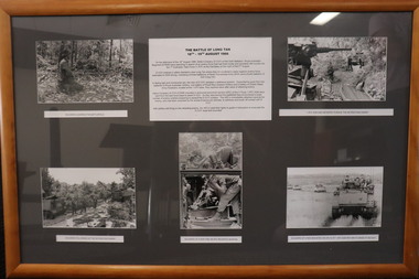
Memorabilia - Long Tan, 2/11/2020
The collage represents different elements of the Battle of Long Tan.The Battle of Long Tan is generally recognised as Australia's major battle in the Vietnam War; the the lingering memory and conclusive evidence of the courage of the soldiers in the battle holds great reverence amongst Vietnam veterans.Framed presentation of Long Tan story with 6 panels - 1 x text and 5 x photos - 4 x landscape, 1 x portraitText panel is a brief introduction of Long Tan story; 5 photos have short descriptive text.vietnam, vietnam war, battle of long tan, diamond valley vietnam veterans sub branch -
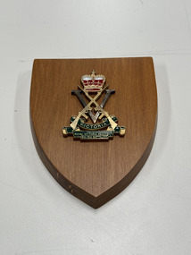 The 5th/6th Battalion Royal Victoria Regiment Historical Collection
Plaque - Presentation Place, 5th/6th Battalion Royal Victorian Regiment
Plaque been presented to Brigadier Lowen, Brig Lowen served in 2/5 Australian Infantry Battalion in WWIIA wooden plaque with decorative motifs, including the corp badge of 5/6 RVR. Located centrally is a large gold coloured Royal Victorian Regiment badge5th/6th Battalion Royal Victoria Regiment 5/6rvr, bhq, brig lowen, 2/5th bn -
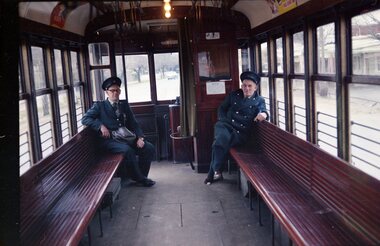 Ballarat Tramway Museum
Negative, Travis Jeffrey, 5/08/1962 12:00:00 AM
Colour Negative No. N402, of the interior of Birney tram with two crew members, driver and conductor sitting at one end of the tramcar. Probably No. 11 - see Reg. Item 2753 for the same Conductor, probably at Golden Square terminus. Photo possibly 17/6/1962. Colour laser printed copy of image stored in box 73. Image scanned at hi res 27/5/2020 and image updated.In red pen on folder that contained negative, "NR92B" and "5 Aug 62". trams, tramways, bendigo, crews, birney