Showing 17154 items
matching bay-bridge
-
 Eltham District Historical Society Inc
Photograph, Tess Justine (Nillumbik Shire Council), Construction work on replacement of Murray's Bridge over the Diamond Creek, Eltham North, 31 Mar 2022
Construction work on replacement of Murray's Bridge over the Diamond Creek on the Diamond Creek Trail Mary (Sweeney) Murray and John Wright Murray selected 80 acres, Lot C Section 16 and Lot 5 Section 17 Parish of Nillumbik, under an occupation license in 1866. John died in 1867 and freehold was granted to his son John in 1873. The farm was known as ‘Laurel Hill’. John Junior was an Eltham Shire councillor and sometime president from 1887 up until 1897. He added Lot A Section 16 to the farm in ca1888. John and his younger brother James arranged to rent/purchase Lot B Section 17, across Diamond Creek to the west, in ca1900. It appears that John and James farmed separately for a few years, with a new homestead built for James ad family on the high point of Lot B Section 17 in ca1910. John sold off Lot 5 Section 17 in 1912. When John died in 1912 James took over the land on both sides of the Diamond Creek. The old homestead on the west side of the Creek disappeared. A farm bridge over Diamond Creek from this period may have been located close to the northern boundary of the farm. John Langlands, owner of the farm known as ‘Ihurst’ on the west side of Diamond Creek to the south of the Murray’s land, died in 1907. In 1909 his land was then subdivided into 100 lots to become the ‘Glen Park Estate’. Other similar subdivisions of nineteenth century farms around Eltham in this period included the ‘Franktonia (or Beard’s) Estate’ to the northeast and ‘Bonsack’s Estate’ between Eltham and Greensborough. Soon after the opening of the railway extension line from Eltham to Hurstbridge in 1912, Glen Park and nearby residents including James Murray agitated for a railway station or siding to be located half-way between Eltham and Hurstbridge, so that the Glen Park residents who used the railway daily did not have to walk into the Eltham or Hurstbridge stations. Some believed Coleman’s Corner (opposite Edendale Farm) was an appropriate spot for the platform. James Murray was among those who thought the railway should be located on his land, closer to half-way between Eltham and Hurstbridge stations. The Railways Commissioners warned that the locals would have to fund these works themselves. The Glen Park Estate residents initially had difficulty accessing Eltham by road, with only an old low-level bridge over Diamond Creek at the south end of their estate. A new timber trestle bridge across the creek, now on Wattletree Road, was opened in 1915. Road access to the north was gained in 1927 when the new Murray’s Road, which crossed the Murray’s land, was built. Residents continued to agitate for a Glen Park station. By 1926 the Railways Commissioners’ preferred site was on the Murray’s land. They arranged an estimate of cost of a full-length platform. The estimate was too much for the locals, who in 1928 argued unsuccessfully for a shorter and hence cheaper platform. By 1929 Murray had agreed to donate the land, but the locals would still have to fund the works. Murray decided, unilaterally it would appear, to commence work on a timber trestle road bridge over Diamond Creek to link the new Murray Road to the proposed station. Late in 1929 he stopped work on the bridge, for reasons unknown, but started work again and completed the bridge in 1931. There is no further newspaper evidence of the campaign for the Glen Park station until 1939, when Murray and another local, Mr Maxwell, met the Railways Commissioner. The Glen Park locale now included 45 homes on the west side of the creek and 20 on the Eltham side. Most of the residents used the train every day. The Commissioner remained adamant that only a full-length platform could be built for safety reasons. It appears the campaign dissolved at this point. The increasing move to cars may have had an impact. There is no evidence of Murray’s bridge ever being connected to Murray’s Road, or of it having wide use for any purpose by locals. James Murray died in 1947 and the farm was taken over by his son James (Jim). Jim started to sell off parts of the farm in the 1980s, retaining a few acres around the ca1910 homestead and building a new house there. Recreation reserves were established along the creek. In ca1990 Murray’s bridge was renovated with steel girders as part of a bike/pedestrian path in the reserve. The old farmhouse was demolished in ca2014. Born digital image (5)diamond creek (creek), diamond creek trail, murrays bridge, ‘laurel hill’, john wright murray, mary (sweeney) murra, john murray jnr, james murray, john langlands, ‘ihurst’, ‘glen park estate’, beard's estate, franktonia, bonsack's estate, glen park estate, glen park railway station -
 Lakes Entrance Historical Society
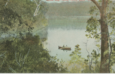
Postcard - Lake Tyers, Victoria Railways, 1905c
Also a tinted postcard titled Lake Tyers Victoria Railways Tourist Series number 03821.1 size 9 x 13.x cm purchased from B RoacheTinted postcard of Lotos Bay Nowa Nowa showing an open waterway surrounded by thick natural vegetation, rowing boat containing two people on lake. Lake Tyers VictoriaLotos Bay Nowa Nowa Lake Tyersforest, waterways -
 Glenelg Shire Council Cultural Collection
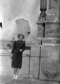
Photograph - Photograph - Syd Cuffe, Town Crier, n.d
Syd Cuffe was the Portland Town Crier from 1983 to 2013. The role of Town Crier was created for Syd Cuffe in 1983 in the lead up to Portland’s 150th anniversary celebrations held in 1984-85. 200 items from Mr. Cuffe’s estate were donated to the Glenelg Shire Cultural Collection. The items relate to his town crying activities and community work across the Shire and further afield.Coloured photo. Syd Cuffe in Town Crier regalia, Oak Bay, Canada, standing on platform, reading. Beach with swings etc in background.Back: 'Cry at Oak Bay 2001' - handwritten blue biro -
 Port of Echuca
Black and white photograph
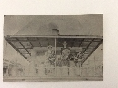
A copy of a black and white photograph of paddle steamer travel along the Murray river. It shows passengers (2 men, 1 girl, 1 boy) on the upper deck of the P. S. Kelvin, around the late 1890-1900. In the background is a third man, Hugh Price, at the wheel of the paddlesteamer. On the back of the photograph is documented as being on the mail run and at the Murray Bridge.Demonstrates passenger transport and travel along the river as well as the delivery of mail services between rural communities around the Murray Bridge, Blanchetown region in South Australia around 1890-1900.Copy of a Black and white photograph of 2 men, 1 girl and 1 boy on upper deck of P. S. Kelvin. In background is a 3rd man, Hugh Price, at the wheel. Documented as being on mail run and at the Murray Bridge (at Echuca)Kelvin on mail run, Murray Bridge. Hugh Price at wheel in rear.murray bridge south australia, p.s. kelvin, mail run, hugh price, cargo, price family collection -
 The Beechworth Burke Museum Research Collection
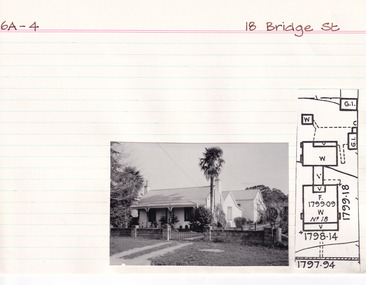
Card (Series) - Index Card, George Tibbits, 18 Bridge Street, Beechworth, 1976
George Tibbits, University of Melbourne. Faculty of Architecture, Building and Town & Regional PlanningIndex system that support the research for Beechworth : historical reconstruction / [by] George Tibbits ... [et al]Arranged by street names of BeechworthEach index card includes: street name and number of property, image of property, allotment and section number, property owners and dates of ownership, description of the property according to rate records, property floor plan with dimensions.beechworth, george tibbitsbeechworth, george tibbits -
 Port Melbourne Historical & Preservation Society
Photograph - Violet Jean Barnett, corner Bay and Little Bay Streets, Port Melbourne and Pat Briggs, Centenary Bridge, Port Melbourne, 1940s
Photocopy of 2 photos on 1 sheet. Pat Briggs on corner Bay and Little Bay Streets. Also Violet Jean Barnett on top of Centenary Bridge. In the background is a paddle steamer on the Baypiers and wharves - station pier, centenary bridge, engineering - bridges, edwin whiting, pat briggs, violet jean barnett -
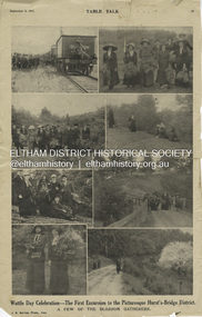 Eltham District Historical Society Inc
Magazine Article, J.E. Barnes, Wattle Day Celebration - The First Excursion to the Picturesque Hurst’s-Bridge District; A few of the blossom gatherers; Table Talk, September 5, p23, 1912
The September 5, 1912 issue of Table Talk celebrated "Wattle Day" where new plantings are made of the national flower and featured images from both Melbourne as well as the first excursion to Hurstbridge. Those from Hurstbridge were photographed by notable WW1 photographer, J.E. Barnes. Also digitised and accessible via National Library of Australia Trove website - (1912, September 5). Table Talk (Melbourne, Vic. : 1885 - 1939), p. 23. Retrieved July 28, 2024, from http://nla.gov.au/nla.news-page17413107 See an article on reflections about Wattle Day on page 29 - SOME REFLECTIONS UPON WATTLE DAY. (1912, September 5). Table Talk (Melbourne, Vic. : 1885 - 1939), p. 29. Retrieved July 28, 2024, from http://nla.gov.au/nla.news-article146180986 The inaugural Hurstbridge Wattle Day Festival was held Saturday, September 1, 1912 when a specially commissioned train brought 1,000 visitors to the district to enjoy the splendour of the wattle in bloom. “Melbourne’s first “Wattle Day” Campaign, the day when Australia’s national flower was to be all pervading in the streets of the metropolis, and sold in sprigs and bunches by hundred of lady volunteers, for purposes of charity, was not blessed with happy climatic conditions on Monday [2 Sep 1912]” - WATTLE DAY. (1912, September 7). Leader (Melbourne, Vic. : 1862 - 1918, 1935), p. 39. Retrieved July 28, 2024, from http://nla.gov.au/nla.news-article198116738 “In connection with Wattle Day celebrations a special train conveyed a thousand people to Hurst's-Bridge last Saturday afternoon [1 Sep 1912]. Lengthy reports of the excursion appeared in the daily papers last Monday. - WATTLE DAY. (1912, September 6). Evelyn Observer and Bourke East Record (Vic. : 1902 - 1917), p. 2 (MORNING.). Retrieved July 28, 2024, from http://nla.gov.au/nla.news-article60656027 See a review of the excursion to Hurst’s-Bridge - HURST'S-BRIDGE EXCURSION. (1912, September 2). The Age (Melbourne, Vic. : 1854 - 1954), p. 9. Retrieved July 28, 2024, from http://nla.gov.au/nla.news-article196255907 The excursion to Hurst’s-Bridge was considered such a success that the Railway department arranged to run another special train to the station on Saturday, October 5, 1912 - HURST'S-BRIDGE EXCURSION. (1912, October 2). The Age (Melbourne, Vic. : 1854 - 1954), p. 10. Retrieved July 28, 2024, from http://nla.gov.au/nla.news-article203325447Inaugural Hurstbridge Wattle Day Festival held 1 September 1912d3-class steam locomotive, hurstbridge wattle festival, special train, tait train, tourism, wattle day campaign, wattle day festival, david smyth collection -
NMIT (Northern Melbourne Institute of TAFE)
Set of photographs: Tony Yeates Sydney Harbour Bridge [1998]
3 Sets held numbered 106, 989 and 990.A series of duotone printS of Sydney Harbour Bridge housed in a hand-made portfolio, bound in the traditional method. Produced probably in 1998. Intended for presentations from NMIT. From National Library of Australia record 'Limited to 1000 prints, increasing in value as the edition is sold out, "The prints are colour calibrated for display under tungsten lighting. They are individually numbered, embossed and placed between acid free trace paper to help protect the prints surface".tony yeates, sydney harbour bridge, presentation pieces, nmit -
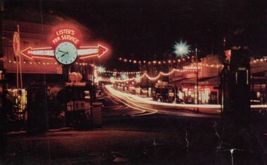 Ballarat Tramway Museum
Photograph - Digital image, looking west along Bridge St Ballarat with the lighting provided for the Royal Visit, 1954
Yields information about the appearance of Bridge St festoon lighting for the 1954 Royal Visit and Begonia Festival. Has a strong association with the Garage on the corner of Bridge St and Main Road.Digital Copy of a photograph sourced by Roger Greenwood as part of his work on the production of a Video Tape on Ballarat's trams. Photographer and source details not provided by Roger. See btm6304doc.pdf Image looking west along Bridge St Ballarat with the lighting provided for the Royal Visit and Begonia Festival 1954. Has the Lister's Garage sign providing directions to Melbourne and Geelong with a clock centrally mounted. Also has a Caltex sign. Photo from a postcard. trams, tramways, bridge st, stones corner, main road, royal visit, begonia festival -
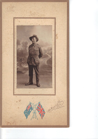 Emerald Museum & Nobelius Heritage Park
Photograph, Nightingale/Thompson Collection, c 1914 - 1918
Photograph of young man in service uniform, identity: Victor George Thomson (1894 - 1948). Victor was the son of William Samuel Thompson and Elizabeth Alice Bishop. Victor was born in GembrookThompson CollectionSepia photograph of soldier on board with coloured flag logo of an embossed coat of armsMakers marks: coloured flags - Australia and UK with W Mason & Co 144 Bridge Road Richmond, Melbourne embossed Australian coat of Arms and embossed bows on top and bottom of photo. Inscription on back: Victor Thompson, my cousinthompson collection, nightingale -
Glenelg Shire Council Cultural Collection
Souvenir - Souvenir teaspoon, n.d
Stuart silver plated scalloped spoon, with enamelled badge at Bridgewater Bay, showing the headland.Front: 'Bridgewater Bay Vic' - gold lettering on badge Back: 'STUART Silverplated Made in Australia'souvenir of portland, bridgewater bay -
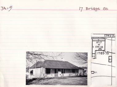 The Beechworth Burke Museum Research Collection
Card (Series) - Index Card, George Tibbits, 17 Bridge Street, Beechworth, 1976
George Tibbits, University of Melbourne. Faculty of Architecture, Building and Town & Regional PlanningIndex system that support the research for Beechworth : historical reconstruction / [by] George Tibbits ... [et al]Arranged by street names of BeechworthEach index card includes: street name and number of property, image of property, allotment and section number, property owners and dates of ownership, description of the property according to rate records, property floor plan with dimensions.beechworth, george tibbitsbeechworth, george tibbits -
 The Beechworth Burke Museum Research Collection
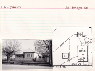
Card (Series) - Index Card, George Tibbits, 26 Bridge Street, Beechworth, 1976
George Tibbits, University of Melbourne. Faculty of Architecture, Building and Town & Regional PlanningIndex system that support the research for Beechworth : historical reconstruction / [by] George Tibbits ... [et al]Arranged by street names of BeechworthEach index card includes: street name and number of property, image of property, allotment and section number, property owners and dates of ownership, description of the property according to rate records, property floor plan with dimensions.beechworth, george tibbitsbeechworth, george tibbits -
 Melbourne Tram Museum
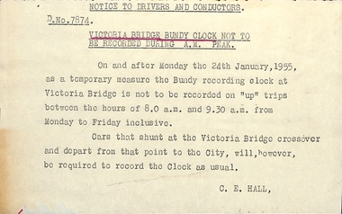
Document - Notice to Traffic Staff, Melbourne & Metropolitan Tramways Board (MMTB), "Victoria Bridge Bundy Clock", Jan. 1955
Notice to traffic staff dated 19/1/1955, Kew Depot about not punching of the Bundy Clock at Victoria Bridge during the AM peak as a temporary measure. Trams that shunted at this location were required to record the clock. This is possibly as the result of an incident at this location with motor car traffic and the difficulty to access the clock in heavy traffic. The circular was attached to another circular with the source details and could not be separated.Yields information about the use of the Victoria Bridge bundy clock in 1955.Notice - printed on special size paper with part of the heading underlined in ink.On rear is pencil archive note "Kew Depot 19/1/1955"tramways, bundy clock, crews, victoria bridge -
 Eltham District Historical Society Inc
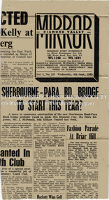
Newspaper - News Clipping, Diamond Valley Mirror, Sherbourne-Para Rd. Bridge To Start This Year?, Diamond Valley Mirror, Wednesday, 4th Sept., p1, 1963
Original clipping from the front page of the Diamond Valley Mirror Vol 5, No 235, Wednesday, 4th Sept., 1963 reporting on Eltham Council news that a move to commence construction of the new Sherbourne Road - Para Road bridge (Montmorency) will commence later in the financial year. Commencement would be subject to the requirements of the railways. Secondary news item included relates to a fashion parade at Briar Hill.Newsprint clippingmontmorency, sherbourne road, para road, bridge, briar hill, bridge construction, diamond valley mirror, railway bridge -
Clunes Museum
Photograph, 2010
.1 Bridge was damaged and closed for repairs for about 6 months .2 Government bridge is higher and was not damaged.1 colour photograph of flooded creek at the newer bridge, water is hitting the bridge .2 colour photo of Government bridge during the floods, water is below the top of the bridge.1 T. Goldworthy 4th Sept. 2010 about midday .2 T. Goldworthy 4th Sept. 2010 about middaybridges, floods, photograph, goverment bridge -
 Lakes Entrance Historical Society
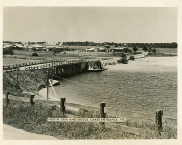
Postcard - Lakes Entrance, 1955
The Marine Parade has been formedBlack and white photograph of North Arm bridge Lakes Entrance VictoriaNorth Arm and Bridge Lakes Entrance, Vicwaterways, roads and streets, bridges -
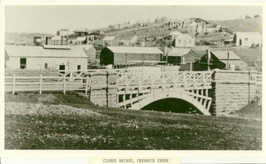 Clunes Museum
Photograph, CRESWICK CREEK
PHOTOGRAPH, BLACK & WHITE COPY, BRIDGE OVER THE CRESWICK CREEK AT CLUNES. (GOVERNMENT BRIDGE)BRIDGE OVER CRESWICK CREEK AT CLUNES. COPIED BY E.J. SEMMENS FROM AN EARLIER PHOTO 1948.local history, photographs, bridges -
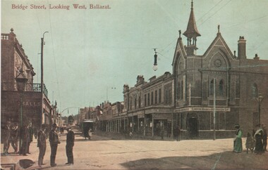 Ballarat Tramway Museum
Postcard - copy, WTP, "Bridge Street looking west, Ballarat"
Bridge St looking West from Peel St. Has a bank on the corner and an tram in the distance. Card dates the view as early 1900's. Card reproduced for Sovereign Hill Gold Mining Township by Rose Stereograph Co. of Glen Waverley c2000. Divided back type with caption, production and the Rose Co. symbol on the rear. Illustration of the same image added 4-1-2024 - by WTP & Co.Yields information about the appearance of Bridge St following the introduction of electric trams in 1905 and has a strong association with the work of Sovereign Hill and Rose Stereograph Co.Postcard reproduction - part sepia coloured and hand coloured. Second copy printed coloured illustration on plain paper.trams, tramways, bridge st, ballarat, esco, rose postcards -
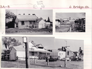 The Beechworth Burke Museum Research Collection
Card (Series) - Index Card, George Tibbits, 6 Bridge Street, Beechworth, 1976
George Tibbits, University of Melbourne. Faculty of Architecture, Building and Town & Regional PlanningIndex system that support the research for Beechworth : historical reconstruction / [by] George Tibbits ... [et al]Arranged by street names of BeechworthEach index card includes: street name and number of property, image of property, allotment and section number, property owners and dates of ownership, description of the property according to rate records, property floor plan with dimensions.beechworth, george tibbitsbeechworth, george tibbits -
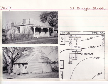 The Beechworth Burke Museum Research Collection
Card (Series) - Index Card, George Tibbits, 21 Bridge Street, Beechworth, 1976
George Tibbits, University of Melbourne. Faculty of Architecture, Building and Town & Regional PlanningIndex system that support the research for Beechworth : historical reconstruction / [by] George Tibbits ... [et al]Arranged by street names of BeechworthEach index card includes: street name and number of property, image of property, allotment and section number, property owners and dates of ownership, description of the property according to rate records, property floor plan with dimensions.beechworth, george tibbitsbeechworth, george tibbits -
 The Beechworth Burke Museum Research Collection
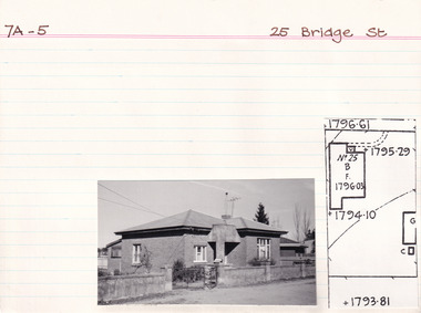
Card (Series) - Index Card, George Tibbits, 25 Bridge Road, Beechworth, 1976
George Tibbits, University of Melbourne. Faculty of Architecture, Building and Town & Regional PlanningIndex system that support the research for Beechworth : historical reconstruction / [by] George Tibbits ... [et al]Arranged by street names of BeechworthEach index card includes: street name and number of property, image of property, allotment and section number, property owners and dates of ownership, description of the property according to rate records, property floor plan with dimensions.beechworth, george tibbitsbeechworth, george tibbits -
 The Beechworth Burke Museum
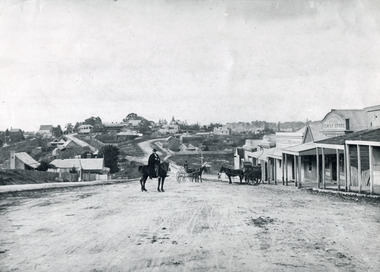
Photograph, c1900
Believed to have been taken sometime between 1858 and 1908, featuring a man with moustache, dressed in hat and long riding coat, seated on a bob-tailed horse, is stopped in the middle of a wide dirt road in Beechworth. He is outside a row of businesses, including R.McKenzie & Sons Grain Store and Mackenzie Family Store (Wholesale & Retail Est. 1855), along a sloping hill. Behind the main rider are a parked horse and laden two-wheeled cart backed up directly outside the grain store's verandah, and another man is driving a horse and four-wheeled wagon forward towards them. At the bottom of the hill is a bridge (Newtown Bridge) with forked road on the far side, leading to a number of houses on both sides of another hill. This image is looking down Bridge Street, Newtown, Beechworth and across to Ford Street (left) and High Street (right). Road-making was a focus of town development during the 1850s, and the wide streets were created on the instructions of the surveyor-general to be between sixty-six and ninety-nine feet wide to give the town a pleasing aspect.This photograph is important in showing the development and expansion of the various businesses and buildings in Bridge Street of Newtown, Beechworth. Black and white rectangular photograph printed on paperReverse: 6980/ PH 118/ 1998.00059/beechworth, new town, newtown, newtown beechworth, local business, mackenzie family store, mackenzie's family store, mackenzie, grain store, bridge, ford steet, high street, colonial australia, australian gold rushes, mining technology, beechworth historic district, indigo gold trail, migration, indigo shire, mckenzie and sons grainstore, mckenzie family store, mckenzie, newtown bridge -
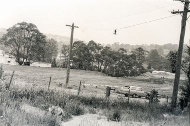
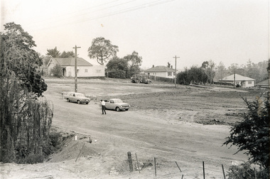
 Eltham District Historical Society Inc
Photograph, Sherbourne Road, Para Road and Simms Road at Briar Hill/Montmorency prior to the upgrade of Sherbourne Road Railway bridge, c.1970
Collection of photographs probably taken around the same time depicting Sherbourne Road, Para Road and Simms Road at Briar Hill/Montmorency prior to the upgrade of Sherbourne Road Railway bridge, c.1970. Photo 01648_ 19 This home owned by Mrs Cameron. Her daughter married a Mr Davey, for whom Davey Road was named - email from M. Jones 20/07/2015 Photographer unknownThese photos are very significant in the documentation of the development of the Briar Hill and Montmorency areas and the changes in the physical landscape along the railway line area.20 black and white prints 9 cm x 13 cm.1970, briar hill, davey road, montmorency, para road, cameron, davey, sherbourne road, simms road, railway line, roadworks -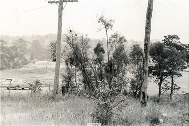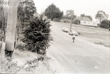
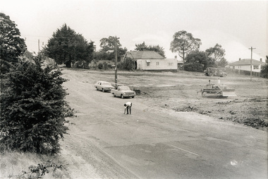
 Eltham District Historical Society Inc
Photograph, Sherbourne Road, Para Road and Simms Road at Briar Hill/Montmorency prior to the upgrade of Sherbourne Road Railway bridge, c.1970
Collection of photographs probably taken around the same time depicting Sherbourne Road, Para Road and Simms Road at Briar Hill/Montmorency prior to the upgrade of Sherbourne Road Railway bridge, c.1970. Photo 01648_ 19 This home owned by Mrs Cameron. Her daughter married a Mr Davey, for whom Davey Road was named - email from M. Jones 20/07/2015 Photographer unknownThese photos are very significant in the documentation of the development of the Briar Hill and Montmorency areas and the changes in the physical landscape along the railway line area.20 black and white prints 9 cm x 13 cm.1970, briar hill, davey road, montmorency, para road, cameron, davey, sherbourne road, simms road, railway line, roadworks