Showing 1495 items
matching maroondah
-
 Eltham District Historical Society Inc
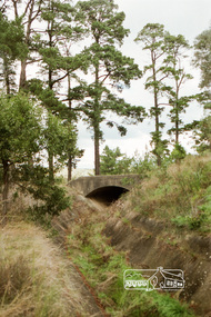
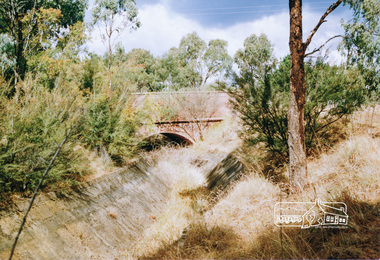
Photograph, Russell Yeoman, Parsons Road Bridge over the Aqueduct
Roll of 35mm colour negative film, 5 stripsKodak Safety 5035parsons road, bridge, maroondah aqueduct -
 Eltham District Historical Society Inc
Photograph, Russell Yeoman, Parsons Road Bridge over the Aqueduct
Roll of 35mm colour negative film, 5 stripsKodak Safety 5035parsons road, bridge, maroondah aqueduct -
 Eltham District Historical Society Inc
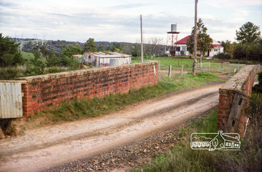
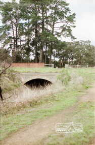
Photograph, Parsons Road Bridge over the Aqueduct, Eltham, c. Jan 1986, January 1986
Roll of 35mm colour negative film, 3 stripsKodak CL 200 5093maroondah aqueduct, parsons road -
 Eltham District Historical Society Inc
Photograph, Aqueduct Trail just near Parsons Road Bridge, Eltham, c. Jan 1986, January 1986
Roll of 35mm colour negative film, 3 stripsKodak CL 200 5093maroondah aqueduct, parsons road -
 Eltham District Historical Society Inc
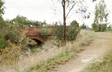
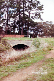
Photograph, Ingrams Road Bridge over Aqueduct, Research, c. Jan 1986, January 1986
Roll of 35mm colour negative film, 3 stripsKodak CL 200 5093maroondah aqueduct, ingrams road -
 Eltham District Historical Society Inc
Photograph, Ingrams Road Bridge over Aqueduct, Research, c. Jan 1986, January 1986
Roll of 35mm colour negative film, 3 stripsKodak CL 200 5093maroondah aqueduct, ingrams road -
 Eltham District Historical Society Inc
Photograph, Ingrams Road Bridge over Aqueduct, Research, c. Jan 1986, January 1986
Roll of 35mm colour negative film, 3 stripsKodak CL 200 5093maroondah aqueduct, ingrams road -
 Eltham District Historical Society Inc
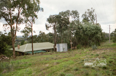
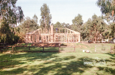
Photograph, House under construction probably viewed from Aqueduct Trail, c. Jan 1986, January 1986
Roll of 35mm colour negative film, 3 stripsKodak CL 200 5093maroondah aqueduct, houses, construction -
 Eltham District Historical Society Inc
Photograph, Ingrams Road Bridge over Aqueduct, Research
Colour photographmaroondah aqueduct, aqueduct, bridge, ingrams road, research (vic.), scan - 35mm negative -
 Eltham District Historical Society Inc
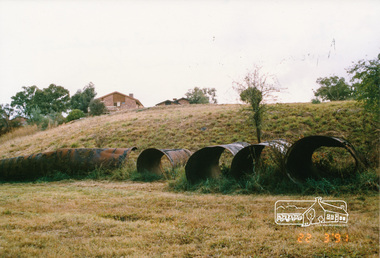
Photograph, Pipes used for original aqueduct crossing of Diamond Creek, Allendale Road, Eltham, 22 March 1991, 22/03/1991
Colour photographmaroondah aqueduct, allendale road -
 Eltham District Historical Society Inc
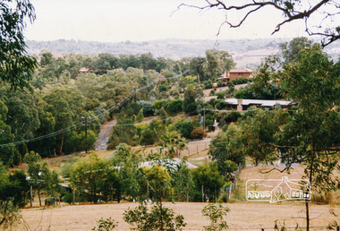
Photograph, View from Aqueduct Path near Parsons Road, Eltham, 1991, 1991
Colour photographmaroondah aqueduct, parsons road -
 Eltham District Historical Society Inc
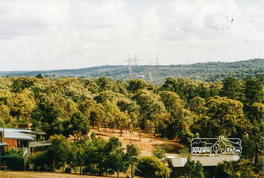
Photograph, View from Aqueduct Path near Wombat Drive, Eltham, 1991, 1991
Colour photographmaroondah aqueduct, wombat drive -
 Eltham District Historical Society Inc
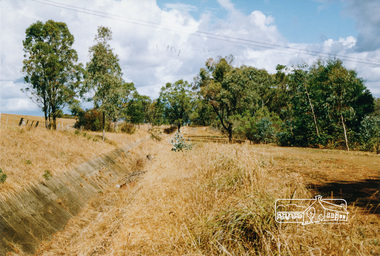
Photograph, Aqueduct path near Allendale Road, Eltham, 1991, 1991
Colour photographmaroondah aqueduct -
 Eltham District Historical Society Inc
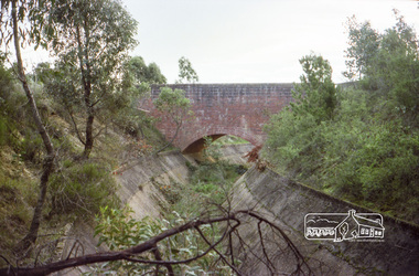
Photograph, Parsons Road Bridge over the Aqueduct, Eltham, 1991, 1991
Colour photographmaroondah aqueduct, aqueduct, bridge, eltham, parsons road -
 Eltham District Historical Society Inc
Photograph, Aqueduct, Research
Colour photograph from aqueduct showing old poultry farm, Researchresearch, maroondah aqueduct, farms, poultry, main road -
 Eltham District Historical Society Inc
Photograph, Old aqueduct pipes, Allendale Road, Eltham, March 1991, 1991
Colour photograph of old aqueduct pipes near Diamond Creek crossing, Allendale Road, Elthammaroondah aqueduct, allendale road, diamond creek, eltham, eltham north -
 Eltham District Historical Society Inc
Book, Pharmacy Dispensing Register, L.J. Thompson, Chemist, Eltham, 21 June 1928-25 October 1929, 1928-1929
Contains a daily record of medicines issued by name/code and to whom but not residence. Last nine pages contain an index of namesHardcover book approx 28 x 12 cm containing 190 pages; front cover loose and damaged (poor condition), rear cover missing; first page torn and first/last few pages suffering water damage with subsequent fading to ink writing though still legible. remaining pages in good condition. Contains a daily record of medicines issued by name/code and to whom but not residence. Last nine pages contain an index of names and pharmacy codes commencing at last page with D; page containing A-C missing.maroondah aqueduct, research (vic.) -
 Ringwood and District Historical Society
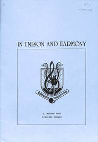
Booklet - The Maroondah Singers 1968-1988, In Unison and Harmony, 1988
History of The Maroondah Singersnon-fictionHistory of The Maroondah Singers -
 Marysville & District Historical Society
Photograph (item) - Colour tinted photograph, Valentine Publishing Co. Pty. Ltd, The Road to Cumberland Valley, Marysville. No. 1, 1923-1963
An early colour tinted photograph of the intersection of the Buxton Marysville Road and the Marysville-Wood's Point Road.An early photograph of the Buxton Marysville Road and the Marysville-Wood's Point Road intersection. The Marysville-Buxton Road joins the Maroondah Highway which leads to Alexandra. The Marysville-Woods Point Road was originally part of the Yarra Track, constructed in the early 1860s to provide access between Healesville and the Woods Point Goldfields. Despite the steep terrain and engineering difficulties, the Yarra Track soon became a busy route used by pack horses, horse-drawn drays, and wagons. Today this sealed mountain road is a popular scenic drive between Marysville and Warburton. On the right of the photograph can be seen 'The Crossways Hotel' which is circa 1920 and one of the oldest buildings still standing in Marysville. 'The Crossways Hotel' survived the 2009 Black Saturday bushfires, through the efforts of the owner using buckets of water from the nearby Steavenson River. In the background can be seen the Poontawan Guest House which later became the Marysville Chalet Guest House which was on the site of the original Steavenson's Hotel. That guest house no longer exists and the Christ Church stands on the land where the guest house once stood. This photograph was published by the Valentine Publishing Co Pty. Ltd as a souvenir of Marysville.marysville, victoria, marysville chalet guest house, crossways hotel, christ church marysville, poontawan guest house, steavenson's hotel, valentine publishing co, souvenir, yarra track, wood's point road, mining, buxton-marysville road, marysville-wood's point road, maroondah highway, alexandra -
 Marysville & District Historical Society
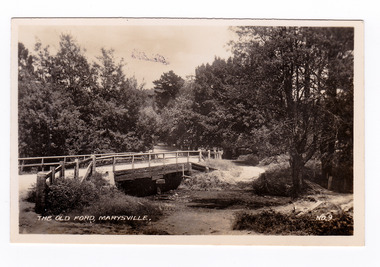
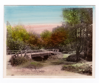
Photograph (item) - Black and white photograph, Valentine Publishing Co. Pty. Ltd, The Old Ford, Marysville No.9, 1923-1963
An early black and white photograph of the old ford in Marysville, Victoria.An early photograph of the bridge at the end of the main street in Marysville which is near the Buxton-Marysville Road and the Marysville-Wood's Point Road intersection. The Marysville-Buxton Road joins the Maroondah Highway which leads to Alexandra. The Marysville-Woods Point Road was originally part of the Yarra Track, constructed in the early 1860s to provide access between Healesville and the Woods Point Goldfields. Despite the steep terrain and engineering difficulties, the Yarra Track soon became a busy route used by pack horses, horse-drawn drays, and wagons. Today this sealed mountain road is a popular scenic drive between Marysville and Warburton. This photograph was published by the Valentine Publishing Co Pty. Ltd as a souvenir of Marysville.marysville, victoria, valentine publishing co, souvenir, buxton-marysville road, marysville-wood's point road, maroondah highway, alexandra, yarra track, mining -
 Marysville & District Historical Society
Photograph (item) - Colour tinted photograph, Valentine Publishing Co. Pty. Ltd, The Old Ford, Marysville No.9, 1923-1963
An early colour tinted photograph of the old ford in Marysville, Victoria. This photograph was published by the Valentine Publishing Co Pty. Ltd. as a souvenir of Marysville.An early photograph of the bridge at the end of the main street in Marysville which is near the Buxton-Marysville Road and the Marysville-Wood's Point Road intersection. The Marysville-Buxton Road joins the Maroondah Highway which leads to Alexandra. The Marysville-Woods Point Road was originally part of the Yarra Track, constructed in the early 1860s to provide access between Healesville and the Woods Point Goldfields. Despite the steep terrain and engineering difficulties, the Yarra Track soon became a busy route used by pack horses, horse-drawn drays, and wagons. Today this sealed mountain road is a popular scenic drive between Marysville and Warburton. This photograph was published by the Valentine Publishing Co Pty. Ltd as a souvenir of Marysville.marysville, victoria, valentine publishing co, souvenir, buxton-marysville road, marysville-wood's point road, maroondah highway, alexandra, yarra track, mining -
 Marysville & District Historical Society
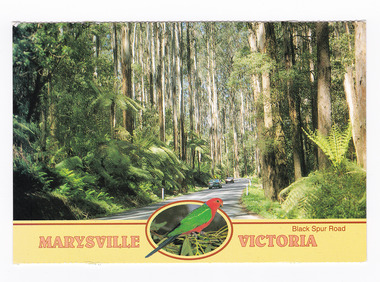
Postcard (item) - Colour postcard, Neil Cutts, Marysville Victoria-Black Spur Road, Pre 2009
A postcard in a series produced by the Rose Stereograph Company in Victoria, Australia as a souvenir of Marysville.A colour photograph of the Black Spur Road near Marysville in Victoria. The Black Spur is known to be one of Victoria's most scenic drives. The road winds through a majestic forest of trees and tree ferns from Healesville to Narbethong and is part of the Maroondah Highway. Rose Series postcard No. 3528. POST CARD The "Rose" Series/ De Luxe Proudly Printed in/ Australia Since 1880 AFFIX/ STAMP/ HERE/ Rose Series/ Post Card No./ 3528 ADDRESS/ POSTCODE Mountain Ash and Treeferns/ Black Spur Road/ MARYSVILLE, VICTORIA, AUSTRALIA/ Photo Neil Cutts Copyright Rose Stereograph Co., Glen Waverley, Victoria (03) 9560 7772marysville, victoria, black spur road, postcard, souvenir, rose series postcard, 3528, healesville, narbethong, maroondah highway -
 Marysville & District Historical Society
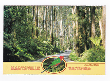
Postcard (item) - Colour postcard, Neil Cutts, Marysville Victoria-Black Spur Road, Pre 2009
A postcard in a series produced by the Rose Stereograph Company in Victoria, Australia as a souvenir of Marysville.A colour photograph of the Black Spur Road near Marysville in Victoria. The Black Spur is known to be one of Victoria's most scenic drives. The road winds through a majestic forest of trees and tree ferns from Healesville to Narbethong and is part of the Maroondah Highway. Rose Series postcard No. 3528. POST CARD The "Rose" Series/ De Luxe Proudly Printed in/ Australia Since 1880 AFFIX/ STAMP/ HERE/ Rose Series/ Post Card No./ 3528 ADDRESS/ POSTCODE Mountain Ash and Treeferns/ Black Spur Road/ MARYSVILLE, VICTORIA, AUSTRALIA/ Photo Neil Cutts Copyright Rose Stereograph Co., Glen Waverley, Victoria (03) 9560 7772marysville, victoria, black spur road, postcard, souvenir, rose series postcard, 3528, healesville, narbethong, maroondah highway -
 Marysville & District Historical Society
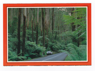
Postcard (item) - Colour postcard, Scancolor (Australia) Pty Ltd, Marysville-Victoria, Pre 2009
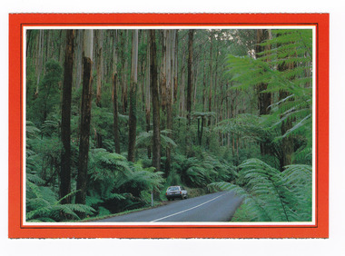
A colour photograph taken along the Black Spur.A colour photograph taken along the Black Spur. The Black Spur is part of the Maroondah Highway and winds its way from Healesville to Narbethong and is considered to be one of Victoria's most picturesque drives. This postcard was produced by Scancolor Australia as a souvenir of Marysville.MARYSVILLE/ Victoria - Australia. On the way to Marysville the narrow highway/ climbs the Black Spur through large tree ferns/ and tall mountain ash trees. scancolor Australia (03) 555 1944 CS 4069marysville, victoria, black spur, maroondah highway, scancolor australia, postcard, souvenir -
 Marysville & District Historical Society
Postcard (item) - Colour postcard, Scancolor (Australia) Pty Ltd, Marysville-Victoria, Pre 2009
A colour photograph taken along the Black Spur.A colour photograph taken along the Black Spur. The Black Spur is part of the Maroondah Highway and winds its way from Healesville to Narbethong and is considered to be one of Victoria's most picturesque drives. This postcard was produced by Scancolor Australia as a souvenir of Marysville.MARYSVILLE/ Victoria - Australia. On the way to Marysville the narrow highway/ climbs the Black Spur through large tree ferns/ and tall mountain ash trees. scancolor Australia (03) 555 1944 CS 4069marysville, victoria, black spur, maroondah highway, scancolor australia, postcard, souvenir -
 Marysville & District Historical Society
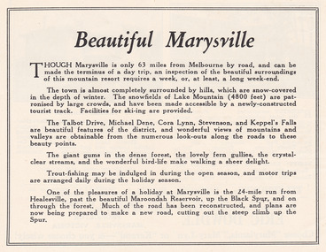
Ephemera (Item) - Advertisement, Beautiful Marysville, Unknown
An advertisement for Marysville and attractions in and around the local area.An advertisement for Marysville and attractions in and around the local area.marysville, victoria, lake mountain, talbot drive, lady talbot drive, michael dene, cora lynn falls, stevenson falls, steavenson falls, keppel's falls, healesville, maroondah reservoir, black spur -
 Marysville & District Historical Society
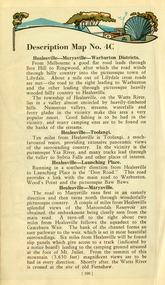
Ephemera (Item) - Book page, Unknown
A page from a unknown book regarding Marysville and the surrounding district including Narbethong, Healesville and Warburton.A page from a unknown book regarding Marysville and the surrounding district including Narbethong, Healesville and Warburton.marysville, victoria, narbethong, healesville, warburton, toolangi, launching place, box hill, ringwood, lilydale, watts river, yea river, sylvia falls, don road, wood's point, baw baws, maroondah reservoir, graceburn weir, mt juliet, fernshaw -
 Marysville & District Historical Society
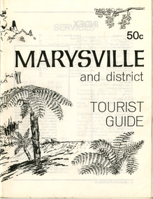
Booklet (Item) - Tourist guide, Ian and Danese Walshe et al, MARYSVILLE and district TOURIST GUIDE, 1982
A tourist guide outlining services, accommodation, activities and places of interest to visit in and around Marysville and the local district.A tourist guide outlining services, accommodation, activities and places of interest to visit in and around Marysville and the local district.marysville, victoria, australia, tourist guide, marysville hotel, castles' store, hawthorne's corner shop, tudor lodge, black spur motel and caravan park, buxton general store, golden fleece roadhouse, marysville garage, burrengeen park, lake mountain, steavenson falls, nanda binya lodge, alpenglow nursery, black spur inn hotel, silver stream trout farm, mccfarlane's grocery, barton's drapery, marysville newsagency, eildon explorer, beauty spot nursery, crossways, pumpernickel, mckenzie's tourist services, blue hills riding school, mountain view horse hire, pitt's garage, maryton park, j l gould sawmill, eildon deer park, eildon weir, maroondah dam, snob's creek, healesville sanctuary, graceburn park, cathedral range, beauty spot walk, tree fern gully walk, michaeldene track, keppel track, woods lookout track, cumberland scenic reserve, cambarville, the big tree, cora-lyn falls, barton's lookout, cumberland falls, sovereign view, wirreanda festival, scenic motel, tower motel, marylands guest house, kooringa guest house, marylyn guest house, mountain lodge, el kanah, marysville hotel motel, buxton hotel motel, black spur inn, buxton caravan park, marysville caravan park, the cumberland, marysville recreation and fun park -
 Marysville & District Historical Society
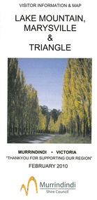
Map (Item) - Tourist map, Murrindindi Shire Council, VISITOR INFORMATION & MAP LAKE MOUNTAIN, MARYSVILLE & TRIANGLE, 02-2010
A visitor information map for Lake Mountain, Marysville and the local district produced by the Murrindindi Shire Council in February 2010. This information guide and map was produced after the 2009 Black Saturday bushfires destroyed most of the township of Marysville.A visitor information map for Lake Mountain, Marysville and the local district produced by the Murrindindi Shire Council in February 2010.Murrindindi Shire Council has made every effort to ensure the information provided at the time/ of printing is correct, but accepts no responsibility for an inaccuracies or omissions.lake mountain, marysville, victoria, australia, visitor information & map, murrindindi shire council, big 4 holiday park taggerty, black spur inn, black spur motel & caravan park, bush creek buddha, buxton hotel motel, cathedral valley farm, chestnut glade, crossways historic country inn, delderfield luxury b&b, kingbilli country estate, marapana agistment park & farm stay b&b, maryton park b&b, pinjarra gardens, sarsens rest, silverstream b&b, tower motel, willowbank at taggerty, wombat cottage, woodlands rainforest retreat, buxton general store and post office, buxton zoo nursery, cathedral view natural therapies, country touch, cross country ski hire, foodworks, highwood health retreat, lake mountain ski hire, lit & beyond, lj hooker, maroondah outdoor equipment/bait & tackle, marysville medical centre, marysville patisserie, marysville ski centre, marysville triangle real estate, marysville visitor information centre, mystic mountains ski hire/outdoors, pat's hairdressing, penni lanes country wares, plant's by shelian -
 Marysville & District Historical Society
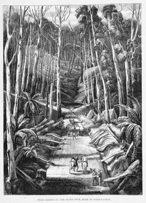
Work on paper (item) - Print of wood engraving, Ebenezer and David Syme, Road Making on the Black Spur, Road to Wood's Point, 1867
A copy of an early wood engraving of the construction of the road over the Black Spur in Victoria.A copy of an early wood engraving of the construction of the road over the Black Spur in Victoria. The Black Spur is known to be one of Victoria's most scenic drives. The road winds through a majestic forest of trees and tree ferns from Healesville to Narbethong and is part of the Maroondah Highway.black spur, wood's point, narbethong, maroondah highway, victoria, wood engraving