Showing 174504 items matching "rock-street"
-
 Halls Gap & Grampians Historical Society
Photograph - B/W, C 1960s
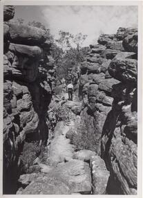
Photo is of area known as ' Silent Street'. It is on path to Pinnacle Lookout.Photo shows a man walking along slabs of rock that form a path between rocky outcrops. He is walking away from the camera. Various shrubs line the path. Gum trees can be seen in background.'Copyright photograph'. This photograph may be reproduced on condition that it is acknowledged as 'Victorian Railways Photograph', p3456- Silent Street . Halls Gap.scenery, wonderland range -
 Northern District School of Nursing. Managed by Bendigo Historical Society Inc.
Photograph - Nursing staff outside "Mayfort"
The Northern District School of Nursing opened in 1950 in to address the issues around nurse recruitment, training and education that had previously been hospital based. The residential school was to provide theoretical and in-house education and practical training over three years. The students would also receive practical hands-on training in the wards of associated hospitals. The Northern District School of Nursing operated from Lister House, Rowan Street, Bendigo. It was the first independent school of nursing in Victoria and continued until it closed in 1989.Three (unnamed) nurses outside "Mayfort", Nurse's accommodation Wattle Street, Bwendigo, the NDSN school's first hostel, View Street. Colour photograph. Mayfort - nurse's accommodation for trainees during P.T.S. intakes.Mayfort, Wattle Streetndsn, nursing, uniforms -
 Charlton Golden Grains Museum Inc
Photograph, Aug 1909
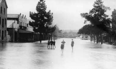
1909 flood, High Street, Charlton Victoria. Children standing in floodwater in High Street looking west from corner of Armstrong Street. Malcolm's Flour Mill and Proctors Double story building.B/W photograph of 1909 flood. Children standing in floodwater in High Street looking West from Corner of Armstrong Street Charlton.flood, charlton, armstrong street, arm -
 Eltham District Historical Society Inc
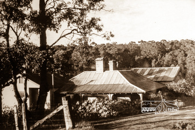
Photograph, "Southern Wood", Brougham Street and Bolton Street, Eltham
Sepia photograph showing 'Southern Wood' at cnr of Brougham and Bolton streets, Eltham. The Heidelberg School artist Walter Withers lived in this property.southern wood, brougham street, bolton street, eltham, walter withers -
 Federation University Historical Collection
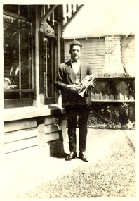
Photograph - Black and White, Vernon Holt, Frank Wright at 6 Pleasant Street North, Ballarat, 1923, Jan 1923
Frank Wright was a renown resident of Smeaton, where he was born. He lived at Laura Villa, and attended Smeaton State School. His father William was a gold miner and his mother's name was Sarah. Their family won many singing and instrumental awards. Frank was tutored by Percy Code and was awarded a gold medal for the highest marks in the ALCM examinations in the British Colonies at the age of seventeen years. He became the Australian Open Cornet Champion by the age of eighteen. A year later, Frank conducted the City of Ballarat Band, and later the Ballarat Soldiers’ Memorial Band. He formed the Frank Wright Frisco Band and Frank Wright and his Coliseum Orchestra. These bands won many South Street awards, and Frank as conductor won many awards in the Australian Band Championship contest. In 1933 Frank Wright sailed to England to conduct the famous St Hilda’s Band and was later appointed Musical Director of the London County Council, where he organized many amazing concerts in parks, in and around the London district. He was made Professor of Brass and Military Band Scoring and conducted at the Guildhall of Music and Drama. Frank was often invited to adjudicate Brass Band Championships around Europe, in Australia, including South Street and in New Zealand. The Frank Wright Medal at the Royal South Street competition is awarded to an individual recognized as making an outstanding contribution to brass music in Australia.Black and white photograph of a man standing standing on a path beside the wall and windows of a house. The man is dressed in a suit and is holding a cornet. The place is 6 Pleasant Street, North Ballarat and the man is Frank Wright.Written is pen on the back - Frank Wright 21, 6 Pleasant St N. Ballarat, Taken by Vernon Holt, Jan 1923frank wright, cornet, conductor, ballarat, vernon holt -
 Greensborough Historical Society
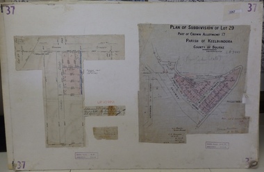
Planning Document, Subdivision Plan # 37. Poulter Avenue and Bicton Street; and, Adeline Street and Grimshaw Street Greensborough, 1971_
Plan of subdivision Lot 29, Part of Crown Allotment, Parish of Keelbundoora, County of Bourke. Poulter Avenue and Bicton Street; and, Adeline Street and Grimshaw Street.An example of hard copy subdivision plans from the Greensborough area. Mainly from the Shire of Diamond Valley era (1964-1994).Plan (2 sheets) mounted on heavy card. subdivision plans, grimshaw street, poulter avenue, adeline street -
 Kew Historical Society Inc
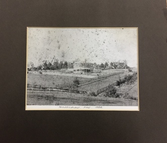
Photograph, 'Hallatrow', Holroyd Street, Kew, 1886, 1886
An important early photograph of a significant Kew mansion - Hallatrow - dating from 1886, soon after it was constructed.What appears to be a reprint of an earlier photograph of Hallatrow, now mounted, originally listed as A'Beckett Street West or Conran Street, but now 6 Holroyd Street in Studley Park. The photograph was originally taken when the house was occupied by the family of Thomas Brodribb. Pencil: “Hallatrow, Kew, 1886” hallatrow - 6 holroyd street - kew )vic), historic buidlings - studley park - kew (vic) -
 Wodonga & District Historical Society Inc
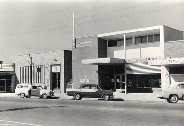
Photograph - Mann Collection Album - High Street East - ANZ Bank; Commonwealth Bank; Henshaw’s Shoes; National Bank, C. 1970s
Elaine Mann was married to David Mann, a successful Wodonga businessman and community leader who passed away in Wodonga in June 2012. David was a member of the Mann family who began their business in Wodonga in 1920. Elaine was a teacher in Wodonga for many years and an active member of the community.This photo collection is of significance as it documents how the businesses and buildings in Wodonga have evolved and contributed to community throughout the late 20th century.High Street East - ANZ Bank; Commonwealth Bank; Henshaw’s Shoes; National Bank. Mahoney's Newsagency on the left hand edge of the photo was located at 168 High Street and the National Bank was at 174 High Street. In 2021 this is the location of the R.A.C.V office. wodonga businesses, high st wodonga, henshaw's shoes, anz, commonwealth bank, national bank -
 Bacchus Marsh & District Historical Society
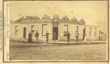
Photograph, Court House Hotel Main Street Bacchus Marsh 1883
This building on the corner of Court House Place and Main Street Bacchus Marsh was a licensed hotel since 1864. Prior to 1864 the building was in use as a saddlery business, established by Joseph Purday and Alfred Smith. In 1864, Purday and Alfred Tanner converted the shop to a hotel. Tanner, followed by his wife Ann, were licensees until 1892. The hotel signage above the door features the Prince of Wales feathers, an acknowledgement of the Prince of Wales Volunteer Light Horse Werribee unit which used the hotel for their meetings. In 1911 the single-storey hotel was demolished and a two-storey brick hotel was built. The identities of the five men and one woman in the photo are not known. The woman at the left of the group is possibly Ann Tanner who was the licensee around the time this photograph was taken. Small sepia unframed photograph on card with gold border framing photograph. Housed in the album, 'Photographs of Bacchus Marsh and District in 1883 by Stevenson and McNicoll'. A group of five men and one woman can be seen standing in front of the Court House Hotel building, Main Street Bacchus Marsh. A large ornate sign around the roofline bears the words “Courthouse Hotel”. Above the door a sign featuring the Prince of Wales feathers also has the name “Ann Tanner.” One of the men is displaying a document which apparently is of some importance, now lost.On the front: Stevenson & McNicoll. Photo. 108 Elizabeth St. Melbourne. COPIES CAN BE OBTAINED AT ANY TIME. On the back: LIGHT & TRUTH inscribed on a banner surmounted by a representation of the rising sun. Copies of this Portrait can be had at any time by sending the Name and Post Office Money Order or Stamps for the amount of order to STEVENSON & McNICOLL LATE BENSON & STEVENSON, Photographers. 108 Elizabeth Street, MELBOURNE. stevenson and mcnicoll 1883 photographs of bacchus marsh and district, hotels bacchus marsh, court house hotel bacchus marsh -
 Flagstaff Hill Maritime Museum and Village
Medal - Token, Richard Parker, ironmonger, Mid-to-late 19th century
This copper penny token was issued in Geelong by ironmonger R. Parker. Richard Parker was an early settler in Victoria. He had a general store in Elizabeth Street, then Collins Street, Melbourne for five years before moving to Geelong in 1844. He soon established several branches of his ironmonger business in towns around Victoria. He encouraged trade by providing customers with the small change of penny tokens in exchange for their more valuable and less convenient silver coins. The token carried a surcharge and was overstamped with the mane of W. Kernot. William Charles Kernot was a chemist at Chillwell, Geelong. The token is of historical significance, representing a form of currency used in Australia's colonial era before Australia had official currency.Token coin; a round copper one penny token. Obverse had promotional text and a sketch and was overstamped with a name. Reverse had the image of a woman holding up a set of balance scales in one hand and a cornucopia in the other, standing beside the sea, with a three-masted sailing ship in the background, There is a formed hole in the metal; on the obverse, it is on the top of the design, on the reverse it is on the bottom of the design. It advertises R. Parker, Ironmonger, Moorabool Street, Geelong, overstamped with the name W. Kernot.Embossed on the obverse: "R. PARKER / IRONMONGER. / MOORABOOL STREET / GEELONG" "W. KERNOT" Embossed on reverse: "AUSTRALIA"warrnambool, shipwreck coast, flagstaff hill, flagstaff hill maritime museum, flagstaff hill maritime village, medallion, coin, token, promotional medallion, one penny, r parker, ironmonger, moorabool street geelong, w. kernot, richard parker, currency, australian currency -
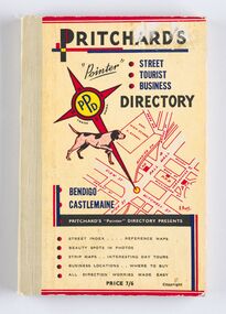 City of Greater Bendigo - Civic Collection
Book - Street Directory, A. E. Pritchard, Pritchards 'Pointer' Street - Tourist - Business - Directory, 1953
As tourism and car culture grew in the early and mid 20th century the need for street and touring directories grew. Bendigo's geographic location within central Victoria and relatively closeness to Melbourne meant that the district has long been an ideal car touring destination. A. E. Pritchard was a licensed surveyor with an office in Bull Street Bendigo and produced these handy bound directories which fit neatly into the car glovebox therefor serving both the local and state demand for high quality printed directories such as these. One hundred and thirty page printed and bound street and touring directory. Includes fold out reference and day touring maps, photographs of local 'beauty' spots and extensive advertising by local businesses. Heavy card used for front and back covers. Three colour print process.Pritchards 'Pointer' Directory Bendigo - Castlemaine.city of greater bendigo commerce, city of greater bendigo tourism, city of greater bendigo leisure, making a nation exhibition, cambridge press, mayor w cambridge -
 Port Melbourne Historical & Preservation Society
Book - Minutes, Municipal Council of Sandridge - Beach Street Committee, 1861 - 1863
First minute book of the Beach Street Committee, 1861-1863. Standard Council notebook, with label 'Municipal Council of Sandridge - Beach Street Committee'local government - borough of sandridge, engineering - roads streets lanes and footpaths, built environment -
 Whitehorse Historical Society Inc.
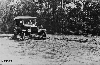
Photograph, Blackburn Road at Heath Street, Blackburn
Large black and white photograph of Blackburn Road near Heath Street. A car driving through water with street behind Photo hanging in Museumblackburn road, blackburn, heath street -
 Kew Historical Society Inc
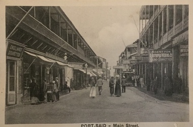
Postcard, The Cairo Postcard Trust, Port Said - Main Street, c.1918
One of a number of 'real photo' and commercial postcards created by or owned by members of the Christian and Washfold families of Kew. The postcards are part of a larger collection of photographs, postcards and publications donated to the collection in May 2021.Sepia postcard of main street in Port Said, located on the north east coast of Egypt on the Mediterranean Sea, showing buildings and stalls lining street.The Cairo Postcard Trust Cairo 953 / Serle 832washfold family, christian family, postcards -- port said, christian-washfold collection -
 Surrey Hills Historical Society Collection
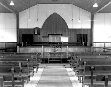
Photograph, Methodist Church, Benson Street, Surrey Hills, c1930, 1930
From a glass negative taken by Ian Barkla's father, Frank Leslie Barkla of 37 Grovedale Road. He was a keen amateur photographer and member of the Melbourne Camera Club. The Benson Street Methodist Club became a Uniting Church during the amalgamation of protestant churches in the 1970s. It was sold and for a brief time was a Chinese church and then sold and demolished with town houses built on the site. There are 2 copies of the photo. There is a comprehensive folder of information about the church compiled by Jocelyn and Ken Hall, who were members of its congregation.1930s image of the interior of the Methodist Church, later Uniting Church, on Benson Street, Surrey Hills. The image shows the church organ, with pipes clearly visible, the pulpit and pews.churches, religious structures and establishments, surrey hills methodist church, sunday schools, surrey hills uniting church, church furniture, pews, pulpit, 1930, benson street methodist church, frank leslie barkla -
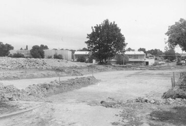 Ringwood and District Historical Society
Photograph, New market - Bond St. entrance to the new street across Charters Seymour Streets, Ringwood 1982
Written on back of photograph, "E661. 8/1/82. Bond St. entrance to the new street across Charters Seymour Streets. Looks south." -
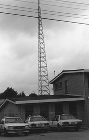 Ringwood and District Historical Society
Photograph, Ringwood Street Police Station, Ringwood 1982
Catalogue card reads, "Ringwood, 1982. Ringwood Street". -
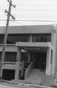 Ringwood and District Historical Society
Photograph, Ringwood Street, Ringwood 1982 (2 views) - Social Security Building
Written on catalogue card, "Ringwood, 1982. Ringwood Street." -
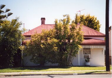 Stawell Historical Society Inc
Photograph, 23 Scallan Street
Colour Photgraph: White weatherboard with verandah red iron roof. Treet in front with lawn. Power Pole to Right.On Reverse: 3.2003 23 Scallan Street Stawell Victoria. -
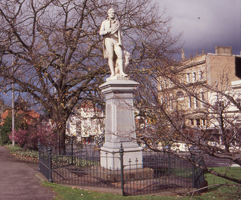 Federation University Historical Collection
Photograph, Robert Burns Statue in Sturt Street, Ballarat, c1990
Colour photograph of statue in Sturt Street Ballarat.robert burns, statue, ballarat, sturt street -
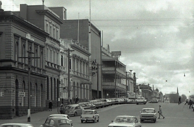
 Federation University Historical Collection
Photograph, Geoffrey Biddington, Dickens Corner, Sturt Street, Ballarat, 1967
Black and white image of Ballarat's Sturt Street.dickens, ballarat, sturt street, dickens food store, bridge street -
 Federation University Historical Collection
Photograph, Geoffrey Biddington, Lydiard Street South, Ballarat Looking East, 1967
Black and white image of Ballarat's Sturt Street.ballarat, bridge street, amp, anz bank, george hotel, lydiard street north -
Federation University Historical Collection
Photograph, Cream Brick Buildings in Hickman Street, Ballarat
Cream Brick Buildings in Hickman Street, Ballaratballarat school of mines, student residences, hickman st ballarat, white flat -
Federation University Historical Collection
Photograph, Roslyn Salmon, Camp Street Marketing Manager
Roslyn Salmon, Camp Street Marketing Managerroslyn salmon, camp street, arts academy -
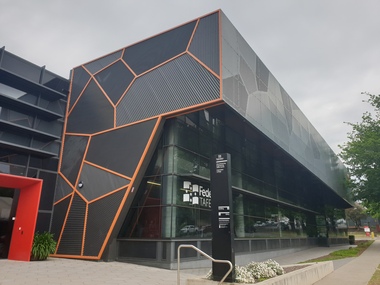 Federation University Historical Collection
Photograph, Clare Gervasoni, Federation TAFE, Grant Street, Ballarat, 16/10/2020
This photograph was taken during lockdowns associated with the COViD 19 pandemic.Photograph of Federation TAFE in Grant Street, Ballaratfederation tafe, s building, manufacturing and engineering skills centre, buildings, smb campus -
 Federation University Historical Collection
Photograph, Clare Gervasoni, Federation TAFE, Grant Street, Ballarat, 2020, 16/10/2020
This photograph was taken during lockdowns associated with the COViD 19 pandemic.Photograph of Federation TAFE in Grant Street, Ballaratfederation tafe, s building, manufacturing and engineering skills centre, buildings, smb campus, architecture -
 Eltham District Historical Society Inc
Photograph, Rocknall, Diamond Street, Eltham, June 1990, 1990
Colour photograph of Rocknall, Diamond Street, Elthamhouses, pise construction, mud brick construction, rocknall, diamond street, eltham -
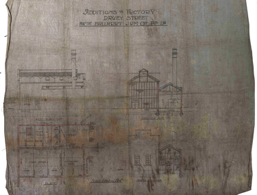 Federation University Historical Collection
Plan, Ballarat Jam Factory, Davey Street, not dated
Plan for the Ballarat Jam Factory, Davey StreetAdditions to Factory Davey Stret for the Ballarat Jam Coy Pty Ltdballarat jam factory, grigsby, industrial heritage, davey street -
Federation University Historical Collection
Plan, Barkly Street Campus, Ballarat East, c1950s ?
Ink on paper plan: Barkly Street Campus. plans, barkly street campus, ballarat east, ballarat girls', ballarat girls' secondary school -
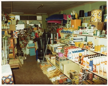 Stawell Historical Society Inc
Photograph, Pleasant Creek Special School, Frank Floyd Pty Ltd. Hardware Store interior Wimmera Street Stawell Nov 1975, Nov 1975
Photographs taken by teacher at Pleasant Creek Training Centre to help train students in living skills and becoming familiar with what shops sold. Part of socializing students for leaving the training centre.Business in Wimmera Street Stawell selling hardware education