Showing 3661 items
matching track
-
 Melbourne Tram Museum
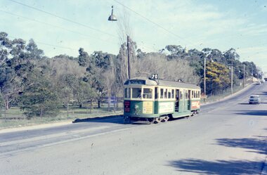
Photograph - Four colour slides - Wattle Park Single Line, Warren Doubleday, 1-8-1970
Set of four photographs taken at the time of the conversion of the Wattle Park route, in Riversdale Road from single line to double track between Warragul Road and the terminus, alongside Wattle Park itself. Yields information on the single line operation of the Wattle Park line prior the conversion to double track operation.Set of four colour Anscochrome slides, of single line operations on the Wattle Park line. .1 - W5 722 on Wattle Park single line, Sat. p.m. .2 - W2 388 meets W2 344 on Wattle park loop - shows the commencement of roadworks. .3 - SW5 853 from the park .4 - W5 738 at Warragul Road - shows the gates to Wattle park and the Caltex Service Station sign.Has photographers slide numbers on each slide.wattle park, route 70, riversdale rd, w2 class, w5 class, sw5 class, trackwork, tram 722, tram 388, tram 853, tram 738, trams, tramways -
 Ballarat Tramway Museum
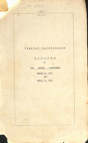
Administrative Record - Meeting Minutes, State Electricity Commission of Victoria (SECV), "Tramway Maintenance Minutes of 3rd Annual Conference March 30 and April 13, 1953", 1953
Document titled "Tramway Maintenance Minutes of 3rd Annual Conference March 30 and April 13, 1953" in the Bendigo and the Geelong offices. See item 9192 for Notes and Agenda for this meeting. Topics covered - cleaning of trams, tracks, track surface repairs, sleepers, car renovation, painting, flooring, notes on a Ballarat Field inspection, disinfecting blinds, electrical systems, truck maintenance, castings, maintenance costs, trolley wheels, employees duties and a summary of actions. Each item where relevant looks back at the actions from the previous conference. Has a list of attendees.Yields information and demonstrates SEC Meeting minutes about discussions between the three Provincial operators about tramcars and operations.Minutes - 50 duplicated foolscap sheets pinned with a folding clip in top left hand corner.trams, tramways, minutes, sec, geelong, ballarat, bendigo, tramcar equipment, maintenance, trackwork, overhead, painting, trolley wheels, motors, one man trams, employees -
 Otway Districts Historical Society
Photograph, Victorian Railways, Gellibrand ballast pit siding, c.1902
In 1902 a ballast siding was opened 4 km south of Gellibrand to provide materials for track construction. A spur siding with a capacity for six trucks was cut into the side of a slope. Above this was erected a loading bin and chute. The stone proved to be of durable quality so the siding continued after 1902 for periodic track re-ballasting works. The points were set for the main line and spiked shut when the siding was not in use. By the mid-1920s the Victorian Railways found it more economic to use ballast from Penshurst, so the siding was closed by 1925 and the rails lifted.B/W. Gellibrand ballast pit siding at 19 miles (30.6 km) south of Colac. gellibrand; gellibrand siding; railways; -
 Melbourne Tram Museum
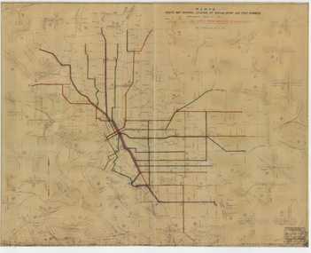
Drawing, Melbourne & Metropolitan Tramways Board (MMTB), "Route Map showing location of special work and pole numbers" "All night tram routes in colours", late 1941
Map of the system shown at two inches = 1 mile. Drawing No. P5799. Shows crossovers, track layouts at junctions, signal cabins roads, railways, and stations. Originally signed by Perway Engineer - 20/12/1940, though originally drawn in 1922. Has been marked up in colour pencil to show the all-night routes and the individual services. The plan shows the lines to Maribyrnong Munitions works along Cordite Ave and Wests Road and the track from Moonee Ponds to Union Road, opened in July 1941, but not the extension to Essendon Airport built in 1942.Demonstrates a detail drawing of Melbourne tramways, junctions and pole numbers.Drawings - dyeline cloth-backed print - titled - "Route Map showing the location of special work and pole numbers" and subtitled - "All night tram routes in colours". trams, tramways, mmtb, trackwork, tramways, junction, map, world war 2, night trams -
 Eltham District Historical Society Inc
Photograph, Harry Gilham, Renovations to Eltham State School No. 209, Dalton Street, Eltham, 1994
Looking to the south windows of the 1921 extension - skylights were put in in the same time as the 1875 set. The heavy beam across the room carried the weight of the folding door track The bottom guide is in another photo).Handwritten (HG's) information and details in blue ink on reverse sidedalton street, eltham primary school, renovations, building construction, buildings, eltham state school no. 209 -
 Greensborough Historical Society
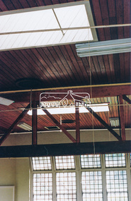
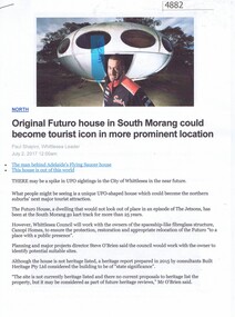
Article - Website, Paul Shapiro, Original Futuro house in South Morang, by Paul Shapiro, 02/07/2017
Of Finnish design, the building has been used as a sales booth at the Apollo Parkways estate, and moved to the TUKE Go-Kart Track on McDonalds Road South Morang, where it is being used as a storage building.3 p. text and col. and black and white photographs (digital reprint of original publication)futuro house, apollo parkways -
 Halls Gap & Grampians Historical Society
Photograph - B/W, C 1898
The Jinker tracks were vitally important during the early years of European settlement. The first routes were known as bridle paths as they were only wide enough to allow the passage of a horse or a person on foot.Photo shows man with pack horse - large gum tree on right side of photoaccess routes, vehicle track, jinker track -
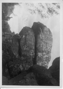 Halls Gap & Grampians Historical Society
Photograph - B/W, C 1940s -- 50s
Rock formation is called " The Woolpacks " and was located on the Wonderland Track at the top of Silent Street -- however on a Broadbent map of the Grampians no.205 this formation was called the " Wool Sacks " ; and the "Woolpacks" was shown on the map close to Venus Bath.Photo shows distinct slabs of rock balancing on each other. Three people appear in the photo -- a man with a boy and a woman. All three are wearing hats. A large rock outcrop can be seen on right of photos -- trees can be seen on left.The Wool Packs F5030scenery, wonderland range -
 Otway Districts Historical Society
Photograph, Les Ogden, Out of Crowes, 1961, 1961
On 8 March 1962, after the line from Crowes to Weeaproinah was shut down. Beginning at Crowes, groups of gangers started removing the tracks, loading them into NQR open wagons pushed by locomotive G42.B/W. Four empty NQR open wagons with a group of gangers tearing up the lines.crowes; beech forest; weeaproinah; railways; -
 Surrey Hills Historical Society Collection
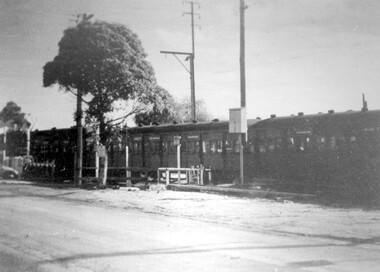
Photograph - Black and White Photograph, Last train to cross the grade level crossing at Elgar Road
The last swing door train was withdrawn from service in 1973. The third track on this line was commissioned in 1971. The overpass bridge was built at this time. These dates place the photo as pre-1971. More research needed.A black and white photo taken from street view of a swing door train crossing a roadway with a simple boom gate barrier. The bonnet of a car can be seen at the LHS of the photo.elgar road, trains, alfred noack, boom gates, swing door trains -
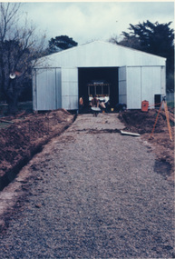
 Melbourne Tram Museum
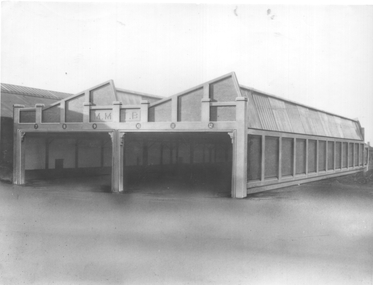
Photograph, Sutcliffe Pty Ltd, Essondon Tram Depot - new building, June 2024
The photograph is of the six road extension built on the south side of the previous depot building at Essendon. Tracks and overhead are yet to be installed - the foreground of the photograph appears to have been "photoshopped". The photograph is about June 1924.Yields information about the second shed at Essendon Depot.Black and white photograph with photographers stamp on rear.Has the stamp of "Sutcliffe Pty Ltd" on rear.trams, tramways, depot, essendon depot, new buildings -
 Melbourne Tram Museum
Pamphlet, Public Transport Victoria (PTV), "Tram service changes route 72", April 2022
Issued for track renewal in Malvern Road between Chapel St and Mandeville Crescent, Armidale between 29 April and 14 May 2022. Gives details of the replacement and alternative bus routes. Produced by the PTV.Yields information about track work in Malvern Road during 2022.Pamphlet - full colour DL 5 fold.trackwork, tramways, malvern road, route 72 -
Melbourne Tram Museum
Pamphlet, Public Transport Victoria (PTV), "Buses replace trams along St Kilda Road and Route 58", November 2022
Issued for track realignment works at the site of Anzac station, Domain Interchange, between 27 November and 17 December 2022. Gives details of the replacement and alternative bus routes. Produced by the PTV and Metrotunnel Authority. Yields information about track work at the site of Anzac station late 1922.Pamphlet - full colour DL 4 fold.trackwork, tramways, st kilda road, anzac station, domain interchange -
Bialik College
Education kit (Item) - Sports Presentation 2004
Recorded in 2004 to capture the sports presentations of Bialik students. Beach, snowfields, riverside, sports tracks and ovals locations. Primary and secondary school levels. Please contact [email protected] to request access to this record. Sports Presentation DVD Bialik College 2004 from aniceguy productions2000s, 2004, sport, celebration, bialik college -
 Melbourne Tram Museum
Photograph - Set of 5 Black & White Photograph/s, Sutcliffe Pty Ltd, c1924
Set of five Photographs, Black and White, of St Kilda Road, with works about to commence to convert the cable tram to electric trams. .1 - Overhead pole holes being dug in the one of the central plantations - pole and a Furphy water cart alongside. A cable tram is passing at speed. Note the scale of the houses opposite and the number of side walk superintendents! .2 - View of St Kilda Road with a few motor cars and one cable tram. Looking south on the Sth Melb. side. .3 - ditto, view of cable tram track, poles laid out on the central plantation, note the street lights. About seven cable trams in the view. Look south towards St Kilda Junction. The Junction hotel is in the view. .4 - similar photo, but further north. Cable trailer 74 in the view. .5 - View of St Kilda Road, vehicle road with a number of vehicles in the view. Looking south on the east side of the roadway. Photos Print and photograph by Sutcliffe of Cromwell buildings 366a Bourke St. Melbourne.In ink and pencil on the rear: .1 - "M&MTB H-60, Kew Depot `1920's (E45 in shed)" and the photographers stamp. .2 - "MMTB St Kilda Road about 1924" and in pencil "Tramway poles erected, pole not removed? Sth Melb side, looking south along motor track" .3 - As above - and in pencil - Tramway poles not erected - ????" .4 - As above with notes in pencil. .5 - As above with notes in pencil. About 1924 KSK print number SA932 to SA936.trams, tramways, st kilda rd, cable trams, conversion, trackwork, overhead, construction, tram 74 -
 Marysville & District Historical Society
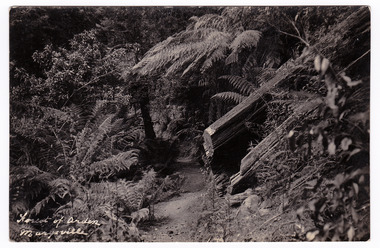
Postcard (item) - Black and white postcard, Forest of Arden Marysville, Unknown
Postcard of early photograph of the Forest of Arden near Marysville.Postcard of early photograph of the Forest of Arden near Marysville.POST CARD PLACE/ POSTAGE/ STAMP/ HEREforest of arden, marysville, forest, tree fern, postcard, souvenir, victoria -
 Bendigo Military Museum
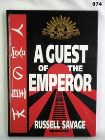
Book, A Guest of the Emperor, 1995
Book hardcover - front cover is coloured red and black. Stylized imperial Japanese flag. Image of rail track in central foreground. Rising sun at top. Writing is in white ink. Japanese writing on left. Pages 141. Illustrated with maps and photos."Donated by BGO YMCA". "Bill 0 with my best wishes - RUSSELL SAVAGE October 1995" Thailand Hellfire Pass - Ex POW Project. books-military-history, japan -
 Glenelg Shire Council Cultural Collection
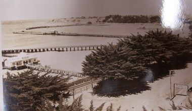
Postcard - Postcard - The Harbour, Portland, n.d
Black and white photographic image of a harbour with two long piers running into it and a shorter jetty with a building on it and circular jetty protruding from it. In the foreground are trees, a dirt road with an RACV sign bridging it to the foreground right and a railway track visible between the trees.Front: THE ROSE SERIES P. 10771/ COPYRIGHT (typed, lower left) THE HARBOUR, PORTLAND (typed, lower centre) -
Tatura Irrigation & Wartime Camps Museum
Photograph, 1917
Taken by photographer for State Rivers and Water Supply Commission.Medium sized black and white photograph. 30/6/1917 Sugarloaf Dam wall construction / Timber form-work ready for concrete pour / Four workmen in foreground / Engine track rail line left / Hut at foot of hill loomingvictorian state rivers and supply commission, sugarloaf dam -
 Anglesea and District Historical Society
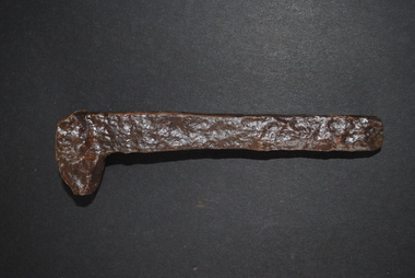
Railway Spike
Rail spike from the Wensleydale rail line. The line ran from Moriac to Wensleydale which closed in 1948 and was dismanatled in 1951. The rail spike is a large nail with offset head used to secure rails and base plates to railroad ties in the track.Nonerailway spike, wensleydale railway, crampon -
 Hume City Civic Collection
Photograph, c1900
A b/w photograph of a cycle race during a sports meeting and picnic at the 'Old Reserve' taken about 1900. Shows spectators lined up along a track, with 3 cyclists riding. 2 tents can be seen behind the spectators to the right.Written on back: Eric Boardman / Sports meeting and picnic Sunbury "Old Reserve" about 1900boardman, eric, sunbury, sports, cycling, bicycles, community activities, old reserve, 1900s, clothing and dress, george evans collection -
 Whitehorse Historical Society Inc.
Photograph, Tally Ho Office Park, 1995
Aerial view of Tally Ho Office Park on corner of Springvale Road & Burwood Highway, East Burwood. Site partly developed. Shows East Burwood Reserve (part) and Bill Sewart Athletics Track. Photo taken facing Burwood Highway.lend lease development pty ltd, tally ho office park, springvale road burwood east, burwood highway burwood east, bill sewart athletic track -
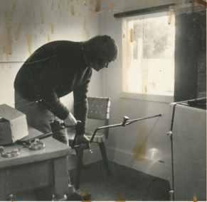 Ballarat Tramway Museum
Photograph - Black & White Photograph/s, Sep. 1977
Photo of Richard Gilbert drilling a hole through the kitchen wall of the BTPS's first Bungaree house as part of the installation of the gas stove. Note the use of a track auger drill to do the work. Stove on right side of photo and parts on the kitchen table.On rear in ink "Bungaree" & "9/77".tramways, trams, bungaree, btps -
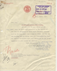 Ballarat Tramway Museum
document - Correspondence, City of Ballaarat, "Re Openings across Tram Tracks", Mar. 1937
Yields information about the correspondence between the SEC and the City of Ballaarat about the opening of tram tracks for underground services.Typed letter on quarto paper, from the City of Ballaarat, dated 15 March 1937, titled ""Re Openings across Tram Tracks" acknowledging receipt of SEC letter regarding the titled. Has various stamps, initials. Signed by the Town Clerk.Various initials and notes in red pencil or ink.tram, trams, letters, sec, city of ballaarat, tram track -
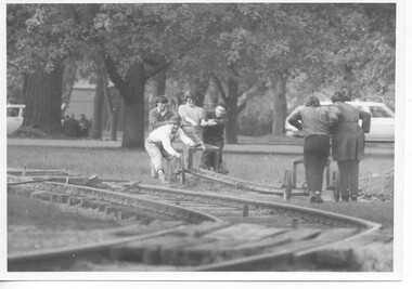 Ballarat Tramway Museum
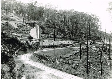
Photograph - Black & White Photograph/s, B. Prentice, mid to late 1974
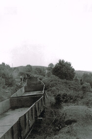
Yields information the construction of the depot fan and access track to Wendouree Parade and has a strong association with the workers in the photograph.Black and white print of the laying out of the rails that formed the access track, taken from the level crossing looking east, mid to late 1973. Featured in the photograph are Gavin Young, ? Bounds, Geoff Cargeeg, Noel Gipps. Photo by Bob Prentice.trams, tramways, depot construction, btps, trackwork -
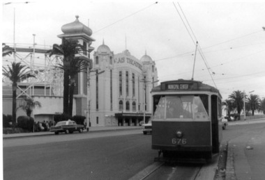 Ballarat Tramway Museum
Photograph - Black & White Photograph/s, 31/10/1965 12:00:00 AM
Set of three Black and white photographs on Kodak paper of an Association of Railway Enthusiasts tram tour with X2 676. The tour featured the use of a Washington DC destination roll. Date of Tour 31/10/1965. 1422.1 - X2 at the terminus of route 69/79 routes at the Esplanade, St Kilda. Note the track is alongside the north side kerb. Has Palais Theatre in the background and Luna Park. Tram showing destination of "Municipal Center" 1422.2 - Hawthorn Road, just north of Balaclava road, looking south. SW6 869 alongside. 676 on temporary track - during the reconstruction of Hawthorn Road - permanent track has been completed alongside. Tram showing destination of "Racecourse" 1422.3 - X2 676 on "Bang Road" Coldblo Road at Malvern depot entry looking east. Tram showing destination of "Friendship Hts". See P.Winspur notes, data sheet for Reg. Item 1418 and Dave Macartneytrams, tramways, tram tours, are, trackwork, mmtb, tram 676, tram 869 -
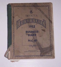 Ballarat Tramway Museum
Administrative record - Log book, Diary, Sands McDougall Pty Ltd, 1951
Yields information about the track maintenance activities of the track gang in Ballarat, the work they did, notes, names and other information.Invicta Australian 1952 Business Diary, No. 40, printed by Sands and McDougall, green Rexene binding, card covers, sewn sections with ruled sheets providing a diary for 1952, 2 days and notes for each page. Has "useful information" sheets at from the diary. Used by the SEC Ballarat track gang to record their daily work, leave, welding, track cleaning, truck driver etc Rear pages - has a detail list of locations, depth of grove for both rails, rail type and type of rail, whether old or new. Loose contents 1 - 1/7/1952 page - SEC memo written on two sheets, dated 4/5/1949 regarding track work and a SEC Ballarat envelope with notes on the sheet. 2 - 3/9/1952- notes on a daily time sheet 3 - 14/11/1952 - sheet of lined paper with notes.tram, trams, sec, ballarat, depot, trackwork, rails -
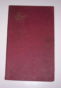 Ballarat Tramway Museum
Administrative record - Log book, Diary, Collins Bros, 1965
Yields information about the track maintenance activities of the track gang in Ballarat, the work they did, notes, names and other information.Collins Australian Diary, No. 324 printed by Collins Bros, dark red card covers, sewn sections with ruled sheets providing a diary for 1966, one week per double page. Has "useful information" sheets at from the diary. Used by the SEC Ballarat track gang to record their daily work, leave, welding, track cleaning, truck driver etc Loose contents With the Engagements 1. - part of a card with roses on it 2. - sheet of paper with tramways account numbers on it 3 - Phillips Electrical Pty Ltd -warranty certificate and envelope 4 - Trams out from depot and Mileage Run sheet with notes on the back (Item Reg. 3706) re track measurements. 25/12/1966 - blank weekly timesheet. Inside rear cover - sheet of paper with names and leave owing details. Names are: Lancaster Wiseman Mark Lakey Edwards Fish Donovan Weightman Wilson Rose Mason Scicluna Smithtram, trams, sec, ballarat, depot, trackwork, rails, scrubber tram -
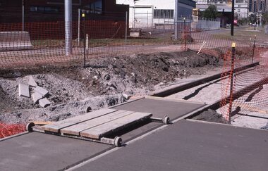
 Ballarat Tramway Museum
Photograph - Colour Print/s - set of 9, 29/09/1972 12:00:00 AM
Set of nine colour prints of the drainage works and initial track construction carried out by the BTPS outside the depot on 29/9/1972. Photos with hand written captions on rear. .1 - Drainage works No. 2 Road, BTPS Depot .2 - ditto .3 - ditto .4 - ditto .5 - ditto, working in the pit by the level crossing .6 - Drivers eye view from Car 27, No. 2 road construction commencing - sleepers laid out with rail alongside. .7 - Construction of No. 2 road BTPS depot proceeds .8 - Time: 5.46 3/4 - Subject "The first blow" R. Gilbert, Sec BTPS drives the first "doggie" on the track connecting No. 2 road of the depot to Wendouree Parade. .9 - Time: 5.47pm. Subject: R. Gilbert, Sec BTPS drives the first doggie on the track connecting the depot to Wendouree Parade. Picture take of the first "doggie" being driven home.In ink on rear of each photo "23/9/72" and details - see abovetrams, tramways, depot, construction, gardens, buildings, btps -
 Melbourne Tram Museum
Album - Robert Thomson Slide Collection, "13.11.2001 to 19.11.2001 October 2003 512-537", 13-11-2001 to 19-11-2001
Photo - see pdf file for further information. Number Brief Description RT149 Docklands - track work RT150 "2" track work at Glenferrie Rd RT151 Box Hill terminus - tram 3029 - "Port Melbourne" route 109 - at Elgar Rd stop RT152 Docklands RT153 East Brighton terminus - tram 112 - "University" - route 64 RT154 "4" - track work excavators at Malvern & Glenferrie Rds RT155 Box Hill terminus - tram 3035 - "via City" route 109 RT156 Docklands - track work RT157 "1" New Junction Malvern - Glenferrie RT158 "3" track work at Malvern & Glenferrie Rds RT159 Docklands - La Trobe St - tram 2073 - "Bundoora RMIT" - route 86 & tram 2003 - "Bundoora RMIT" - route 86 RT160 Docklands RT161 Docklands - Collins St extension RT162 Docklands - track work RT163 Collins St -tram 124 - "West Preston" - route 112 - at Town Hall stop RT164 Port Melb terminus - tram 278 - "Mont Albert" - route 109 RT165 Swanston St - tram 67 - "University" - route 6 RT166 Port Melb terminus - "Mont Albert" - route 109 RT167 Camberwell Depot - tram 971 - "City" - route 55, tram 881 - "Camberwell" RT168 Victoria Pde - tram 3004 -"Mont Albert" - route 109 RT169 Victoria Pde - tram 175 - "St Kilda Fitzroy St" - route 112 & "Mont Albert" - route 109 RT170 Spencer St - tram 957 - "City Circle" route 0 & tram 195 - "West Preston" - route 12 RT171 Domain Road Interchange - tram 134 "West Coburg" - route 55 7 tram 22 - "Camberwell" - route 72 RT172 St Kilda Rd - tram 96 - "University" - route 67 RT173 Swanston St - tram 24 - at Collins St RT174 West Coburg - tram 130 - "Doman & St Kilda Rds" - route 55Demonstrates the work of Robert Thomson in photography, collection and/or production of slidesAssembled album in a black presentation folder of 26 colour slides, collected or produced by Robert Thomson. All photographs have been scanned and placed on the Museum's G drive. A list of all photographs with details has been compiled. melbourne, tramways, trams, track construction