Showing 8126 items
matching bridge
-
 Orbost & District Historical Society
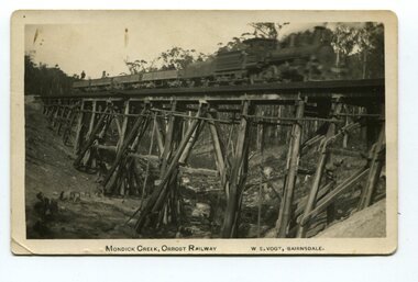
black and white photograph, Vogt. W.S, first half 20th century
This 97km Bairnsdale to Orbost extension through rugged terrain was reputed to have been the most difficult rail project undertaken in Victoria. This wooden bridge was one of the unique railway bridges of the East Gippsland Railway line. Mundic Creek Bridge is of unique design because the line crosses at a very sharp angle. This bridge like many others on the line have "disappeared". This one, probably because of a bushfire.The Bairnsdale to Orbost rail line contains the most varied range Of timber & timber composite bridges on any Victorian line. This photograph is a record of that. A black / white photograph of a train on a wooden railway bridge at Mundic Creek.on front - Mundic Creek, Orbost Railway W.S.Vogt, Bairnsdalemundic-creek-bridge east-gippsland-railway -
 Glenelg Shire Council Cultural Collection
Photograph - Photograph - Portland scene, c. 1970
Photographic print of a rephotographed photograph. Image shows lower north slope Observatory Hill, fence along base, then wooden bridge over Salt Creek that drains into bay, near the Spit Portland.Front: 'Bridge over Portland drain' - green ink -
Hume City Civic Collection
Photograph, Jacksons Creek Viaduct
The four arch railway bridge, known as the Jacksons Creek Viaduct Bridge, spans the Jacksons Creek north of the Sunbury Railway Station. The weir at the base of the bridge was used to dam water as well as ensuring a water supply for the steam trains. The pump house at the base of the bridge was where the water was pumped and then taken to the railway station for the steam engines.This bridge is one of notable four railway bridges along the railway line that are in Sunbury. An enlarged black and white photograph with a white border of a high bridge over a watercourse.bridges, jacksons creek viaduct, jacksons creek viaduct bridge, railways -
 Rutherglen Historical Society
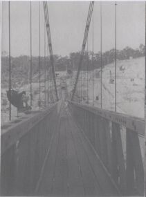
Image, c1928
Photocopies of Hume Weir photographs 1928-29One of three black and white photographs, photocopied onto a single sheet of A4 paper. This one is of a walkway on a suspension bridge.Written on paper next to photo: "Along the 600' suspension bridge 300' above creek"hume weir, suspension bridge, bridges -
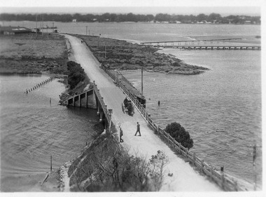
Phillip Island and District Historical Society Inc.
Photograph
Phillip Island Suspension Bridge. First road connection to mainland at San Remo. built 1938/40, demolished 1970. Part of an album compiled and donated by Mrs Helen Jansson.Print of approach to Phillip Island suspension Bridge. Shows second Bridge without middle span in background.local history, photography, photographs, slides, film, civil engineering, bridges, phillip island bridges, black & white photograph, mrs helen jansson, phillip island bridge -
 Lakes Entrance Regional Historical Society (operating as Lakes Entrance History Centre & Museum)
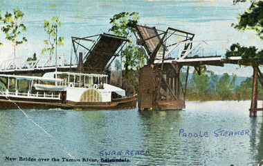
Photograph, V S M Series, 1920 c
Hand tinted postcard showing Paddle Steamer 'Tanjil' passing upstream under the open Swan Reach Bridge on the Tambo River, East Gippsland, Victoria.New Bridge over the Tambo River Swan Reach Paddle Steamerships and shipping, waterways, jetties -
 Phillip Island and District Historical Society Inc.
Photograph, ?
One of a collection of photographs purchased from Photo First, Thompson Avenue, Cowes, when it closed in June, 2014. The bridge was built in 1939 and opened in November 1940. Large Black & White photograph of Phillip Island Suspension Bridge, the first bridge from San Remo to Newhaven.phillip island suspention bridge, suspension bridge, photo first phillip island -
 Halls Gap & Grampians Historical Society
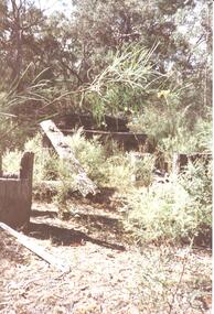
Photograph - Coloured
An old bridge at Back Creek on the Heatherlie Quarry Rail line.Photo shows the beginning of a bridge that has become dilapidated with time. Large beams lie around covered in weeds. Bushy growth has grown over the bridge.structures, bridges -
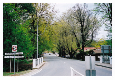
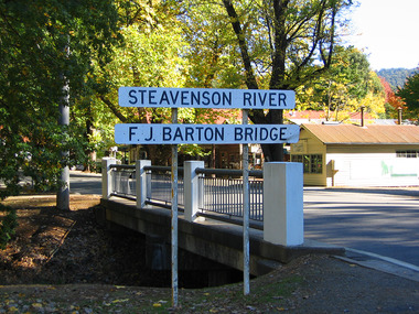
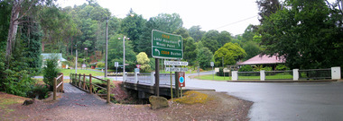 Marysville & District Historical Society
Photograph (Item) - Colour photograph, Travel Victoria, Unknown
A colour photograph of the F.J. Barton Bridge in Marysville in Victoria.A colour photograph of the F.J. Barton Bridge in Marysville in Victoria. The F.J. Barton Bridge was named after Frederick John Barton. The Barton Family were amongst Marysville's first pioneering families.f.j. barton bridge, f.j. barton, marysville, victoria, photograph -
 Marysville & District Historical Society
Photograph (Item) - Colour photograph, 09-2001
A colour photograph of the F.J. Barton Bridge in Marysville in Victoria.A colour photograph of the F.J. Barton Bridge in Marysville in Victoria. The F.J. Barton Bridge was named after Frederick John Barton. The Barton Family were amongst Marysville's first pioneering families.SEPT. 2001fj barton bridge, marysville, victoria, photograph, frederick john barton -
 Marysville & District Historical Society
Photograph (Item) - Colour photograph, Unknown
A colour photograph of the F.J. Barton Bridge in Marysville in Victoria.A colour photograph of the F.J. Barton Bridge in Marysville in Victoria. The F.J. Barton Bridge was named after Frederick John Barton. The Barton Family were amongst Marysville's first pioneering families.fj barton bridge, marysville, victoria, photograph, frederick john barton -
 Orbost & District Historical Society
photograph, first half of 20th century prior to 1976
Purchased from Orbost Op shop several years ago. Original owner unknown. This bridge over the Snowy River was opened on July 4 1922. It was constructed in 1922 alongside the previous suspension bridge. Its building was a combined effort of the Victorian Railways and the Country Roads Board at a cost of 35,000 pounds. It was replaced in 1976 by the present bridge after several major floods.This bridge was replaced in 1976 after several major floods.A wooden framed photograph of the second Snowy River bridge at Orbost.photograph snowy-river-bridge -
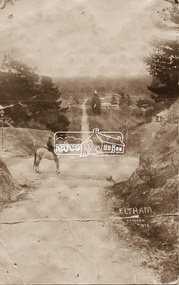 Eltham District Historical Society Inc
Photograph - Photo postcard, J.H. Clark, Eltham, looking down Bridge Street near intersection with Main Road, c.1910
This postcard depicts the view down Bridge Street from east of Maria Street (Main Road) circa 1910. A man on a horse stands in the foreground. J.H. Clark Photo is stated under the title. From the same collection as accession no. 00778, (Yarra at Eltham) - sent from Eltham and addressed to "Mr J. L. Brown, "Elthamville", Tinning Street, Brunswick" "with love from Nellie" who was most probably a member of the extended Brown family, and no. 00779 (Pond near Eltham Park). "Dear John, As you see " can be ascertained on the reverse of this card. Sending postcards to family and friends including short messages was a common form of communication in the early 20th century. Photographer: J.H. Clark John Henry Clark was the youngest of three boys born to William Henry Clark (1823-1877) and Maria White (1843-1914). He and his brothers, William Charles Clark (1872-1945), Clement Kent Clark (1874-1912) operated a photography business (Clark Bros.) from 25 Thomas Street, Windsor near Prahran during the period c.1894 to 1914. Following death of Clement in September 1912 and their mother in 1914, the Clark Bros business appears to have dissolved, the premises demolished, and a new house was under construction in 1915. John set up business independently in 1914 operating out of 29 Moor Street, Fitzroy where he is registered in the 1914 and 1915 Electoral Rolls. By 1916 John had relocated to Eltham where he continued his practice as a photographer and took many of the early images around the district of Little Eltham. Around 1930 John changed professions and opened a small cobbler's shop in 1931 near the pond opposite Dalton Street adjacent to the Jarrold family cottage. He never married and continued his profession as a bootmaker from this little shop, maintaining a close relationship with Mrs Jarrold for the rest of their lives. His bootmaker shop remains today beside the Whitecloud cottage and is one of only three remaining shops in the area from the early 20th century. There are a couple of images of Eltham taken by Clark Bros. in the Eltham District Historical Society collection, one such example being Hunniford’s Post Office with Miss Anne Hunniford out front (EDHS_00140 - marked on the back of the print, Clark Bros., 25 Thomas St. Windsor), which would date this image between c.1894 and 1914. Other early images of Eltham taken by John Henry Clark are marked on the face “J. H. Clark Photo” and it is assumed these are dated between 1914 and 1930. It is noted that the Grant of Probate for John H Clark of Eltham South dated 5 April !957 (513/387) records his occupation as "X Photographer".Sending postcards to family and friends including short messages was a common form of communication in the early 20th century. Original sepia photo postcard hand dated 20 May 1911 in very poor condition which has been removed from an album. Glue residue and album page adhering preventing information being read Eltham J.H. Clark Photoeltham, bridge street, j.h. clark photo, main road, maria street, horse rider -
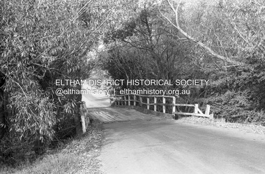 Eltham District Historical Society Inc
Photograph (Item) - Print, Roy Johnson, Bridge over creek near Leisure Centre, 1988
Brougham Street Bridge Roy Johnson 1988 Entrant No. 74 Ref: Series 34, Items 93-96 SHIRE OF ELTHAM COMMUNITY PHOTOGRAPHIC SURVEY Photography is an artform which many of us practice, sometimes purely for artistic pursuit, sometimes to record the people and events in our lives. In 1988, as part of a local Bicentennial project, the Shire of Eltham conducted the Eltham Community Photographic Survey. Up to 100 entries were to be selected by a panel of photographers for entry into the Eltham Photographic Survey Exhibition. Entries had to be submitted by May 13, 1988. Entrants whose images were selected for the exhibition were contacted and requested to further submit an entry form providing entrant’s name, area of residence, age, and proposed captions. These details were then used to produce labels for the exhibition mounts. Where negatives had not been supplied, these were requested to support the display of printed enlargements mounted on 10” x 8” cardboard. The mounted prints were made available post exhibition for sale at $8.50 each for colour prints and $7.00 for B&W prints. Residents in the Shire were invited to collect a free roll of film and take a photograph of what they either liked or did not like about the area. A total of 160 entrants submitted multiple entries for the exhibition. Of those selected for exhibition, entrants ranged in age from 9 to 70 years. All custom colour and black and white printing for the exhibition was completed by Wattle Studios of Eltham. The Eltham Photographic Survey was jointly auspiced by the Shire of Eltham and Wattle Studios, of 953 Main Road, Eltham. The project was greatly assisted by: • David McRitchie, Media Studies Lecturer Victoria College, Rusden Campus. • Ian and Annette Toohill of Wattle Studios • Tracy Naughton, Eltham Community Arts Officer • Neville Emerson Pty. Ltd. • Superior Press, Eltham • Kodak Australasia Pty. Ltd. • Agfa Gevaert Ltd. • Townsend Colourtech Pty. Ltd. • The Australian Bicentennial Authority • Eleanor Bowers, Secretary, Eltham Arts Council The exhibition was placed on display in the Woolworths Arcade, Eltham between Monday June 6th and Saturday June 11, 1988. It was also intended to hold the exhibition at a venue in the Shire’s North Riding from Monday, June 20 to Friday June 24. It was then displayed at the Were Street Theatre, Montmorency from Friday, June 24 to Thursday, July 7. Series 34: Eltham Community Photographic Survey 1988 - Prints & Documentation Series consists of 117 photographs of Shire scenes taken by members of the community. Items I - 41 are larger photographs mounted on card, which were exhibited. Items 42 - 117 are unmounted copies, alternative takes and other entries. Corresponding negatives contained in Series 35: Eltham Community Photographic Survey 1988 – Negatives which consists of 267 colour and B&W negatives and one colour slide of Shire scenes taken by members of the community. The negatives are arranged by the entrant number of the photographer. The Eltham Community Photographic Survey collection is significant to the local community as it was curated by the local community - ordinary people of all ages - representing what they liked and did not like in the area where they lived. It represents an unfiltered representation of the Shire of Eltham as it was in 1988. It also represents one of many projects as part of the national programme of events and celebrations to commemorate the bicentenary. It is a time capsule of life in the 1980s of this urban and rural municipality in Melbourne's north. Rear: 'Series 34' and the 'Item No.' in orange inkshire of eltham archives, bicentennial project, eltham, eltham community photographic survey, series 34, series 35, brougham street bridge, film - ilford fp4, roy johnson, scan - 35mm negative -
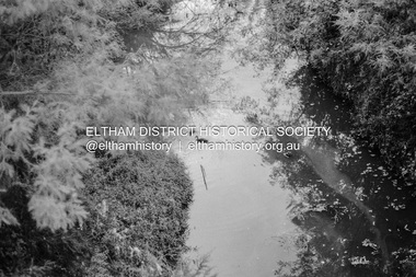 Eltham District Historical Society Inc
Photograph (Item) - Print, Roy Johnson, Diamond Creek from bridge near CLC, 1988
Diamond Street Bridge Roy Johnson 1988 Entrant No. 74 Ref: Series 34, Items 93-96 SHIRE OF ELTHAM COMMUNITY PHOTOGRAPHIC SURVEY Photography is an artform which many of us practice, sometimes purely for artistic pursuit, sometimes to record the people and events in our lives. In 1988, as part of a local Bicentennial project, the Shire of Eltham conducted the Eltham Community Photographic Survey. Up to 100 entries were to be selected by a panel of photographers for entry into the Eltham Photographic Survey Exhibition. Entries had to be submitted by May 13, 1988. Entrants whose images were selected for the exhibition were contacted and requested to further submit an entry form providing entrant’s name, area of residence, age, and proposed captions. These details were then used to produce labels for the exhibition mounts. Where negatives had not been supplied, these were requested to support the display of printed enlargements mounted on 10” x 8” cardboard. The mounted prints were made available post exhibition for sale at $8.50 each for colour prints and $7.00 for B&W prints. Residents in the Shire were invited to collect a free roll of film and take a photograph of what they either liked or did not like about the area. A total of 160 entrants submitted multiple entries for the exhibition. Of those selected for exhibition, entrants ranged in age from 9 to 70 years. All custom colour and black and white printing for the exhibition was completed by Wattle Studios of Eltham. The Eltham Photographic Survey was jointly auspiced by the Shire of Eltham and Wattle Studios, of 953 Main Road, Eltham. The project was greatly assisted by: • David McRitchie, Media Studies Lecturer Victoria College, Rusden Campus. • Ian and Annette Toohill of Wattle Studios • Tracy Naughton, Eltham Community Arts Officer • Neville Emerson Pty. Ltd. • Superior Press, Eltham • Kodak Australasia Pty. Ltd. • Agfa Gevaert Ltd. • Townsend Colourtech Pty. Ltd. • The Australian Bicentennial Authority • Eleanor Bowers, Secretary, Eltham Arts Council The exhibition was placed on display in the Woolworths Arcade, Eltham between Monday June 6th and Saturday June 11, 1988. It was also intended to hold the exhibition at a venue in the Shire’s North Riding from Monday, June 20 to Friday June 24. It was then displayed at the Were Street Theatre, Montmorency from Friday, June 24 to Thursday, July 7. Series 34: Eltham Community Photographic Survey 1988 - Prints & Documentation Series consists of 117 photographs of Shire scenes taken by members of the community. Items I - 41 are larger photographs mounted on card, which were exhibited. Items 42 - 117 are unmounted copies, alternative takes and other entries. Corresponding negatives contained in Series 35: Eltham Community Photographic Survey 1988 – Negatives which consists of 267 colour and B&W negatives and one colour slide of Shire scenes taken by members of the community. The negatives are arranged by the entrant number of the photographer. The Eltham Community Photographic Survey collection is significant to the local community as it was curated by the local community - ordinary people of all ages - representing what they liked and did not like in the area where they lived. It represents an unfiltered representation of the Shire of Eltham as it was in 1988. It also represents one of many projects as part of the national programme of events and celebrations to commemorate the bicentenary. It is a time capsule of life in the 1980s of this urban and rural municipality in Melbourne's north. Rear: 'Series 34' and the 'Item No.' in orange inkshire of eltham archives, bicentennial project, eltham, eltham community photographic survey, series 34, series 35, diamond creek (creek), diamond street bridge, film - ilford fp4, roy johnson, scan - 35mm negative -
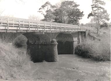 Hume City Civic Collection
Photograph, Early 1970s
The Macedon Street Bridge over Jacksons Creek is important because it was built on one of Victoria's first important roads. It replaced a smaller lighter bridge in 1857 and continued to be used until the early 1970s.A black and white photograph of a two arched bluestone bridge over a creek. A wooden post and rail fence painted white has been constructed in front of the original stone wall of the bridge.bridges, bluestone bridges, jacksons creek, macedon street, george evans collection -
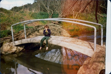 Darebin Parklands Association
Clifton Brigde, 1979-1980
The bridge was designed and constucted by Sidney Clifton, an engineer who lived in a house neighbouring the parklands.Colour photograph. Child sitting on Clifton Bridge. -
 Lakes Entrance Regional Historical Society (operating as Lakes Entrance History Centre & Museum)
Postcard, 1917c
Also sepia toned photographic print 10cmx15cm, good condition old cat No 310 or 318? (Club Hotel and Hummocks area cropped from top) also Black and white photographic print 12.5cmx18cm, good condition- 2 copies 'Original T-Beam bridge opened Sept 1917 on reverse P01151-3.Black and white photographic miniature postcard showing the concrete bridge over the North Arm, showing the extended abutments, and shortened bridge length compared to previous bridge, causing restriction of waterway. Two walkers and horse drawn vehicle, buggy, on bridge. Remaining piles of wooden bridge upstream of bridge, telegraph poles upstream of bridge and across mudflats. Bridge to Bullock Island from mudflat, Club Hotel, Cunninghame Arm, and sand hummocks in distance. Lakes Entrance Victoriabridges, waterways, coast, transport, hotels -
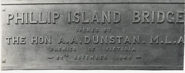 Phillip Island and District Historical Society Inc.
Photograph, 29/11/1940
One of a collection of over 400 photographs in an album commenced in 1960 and presented to the Phillip Island & Westernport Historical Society by the Shire of Phillip IslandPhotograph of the Bronze Plaque on the first Phillip Island Bridge showing wording clearly. 29/11/1940Phillip Island Bridge opened by The Hon A. A. Dunstan M. L. A. Premier of Victoria 29th November 1940.local history, photography, photographs, bronze plaque on first phillip island bridge, black & white photograph, phillip island bridge, the hon. a. a. dunstan. mla, john jenner, bryant west -
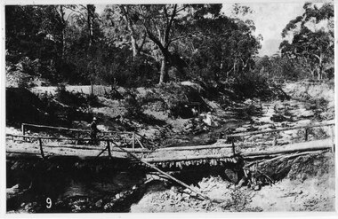 Halls Gap & Grampians Historical Society
Photograph - B/W, C 1880
This photo shows the first Delley's Bridge, built to cross the Fyans Creek to provide access to Halls Gap and beyond in the 1880's. The bridge was swept away a number of times in floods. This bridge was replaced by a higher timber structure but constant erosion of the creek bank eventually led to its replacement by a timber and concrete structure. After nearly 50 years of its use, wear and tear necessitated a fourth bridge to be erected in 2001.A log bridge across a creek with a man standing on the bridge. A woman in a white dress and hat is beside the creek and a man is standing near her on the bank. In the left background a house can just be seen through the trees.structures, bridges -
 Clunes Museum
Photograph
BRIDGE OPENING 14TH APRIL 1986BRENDA TREMBATH, BETH COLLINS, LYN DUNNE AT BRIDGE OPENING.local history, photography, photographs, bridges -
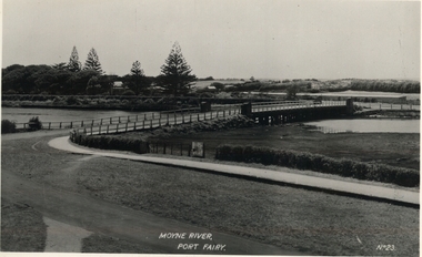 Port Fairy Historical Society Museum and Archives
Postcard, Moyne River, Port Fairy
Circa 1902Black and white photograph of the Moyne river road bridge with no traffic taken for use as a PostcardMoyne River, Port Fairy - No23moyne bridge, circa 1900's, moyne river, bridge, road -
Lakes Entrance Regional Historical Society (operating as Lakes Entrance History Centre & Museum)
Photograph, 1/05/2005 12:00:00 AM
The bridge was built 1912 / 13 c on concrete piers, single track with steel guard fence with concrete road bridge adjacen.tColour photograph of the remnant of railway bridge across the Mitchell River at Bairnsdale Victoriarailway -
Glenelg Shire Council Cultural Collection
Postcard - Postcard - Suspension bridge Casterton, 1900-1930
SOURCED FROM CASTERTON TOWN HALL (FORMER SHIRE OF GLENELG) Sourced from Casterton Town Hall (Former Shire of Glenelg)Postcard, black and white,, showing the suspension bridge at Casterton, view across river towards townshipFront: 'SUSPN BRIDGE CASTERTON' Back: Handwritten correspondence, addressed to 'Miss M. Sythaleigh, Henty St Casterton' -
 Sunbury Family History and Heritage Society Inc.
Photograph
The photograph was taken when some work was being carried out on one of the arched railway bridges on the Sunbury line. The bridge spans the Jackson Creek and across the Rupertswood viaduct. The bridge over the Rupertswood Viaduct is one of the five significant bridges which span the railway line between Diggers Rest and Clarkfield.A black and white photograph of a bridge with scaffolding erected around the base of the arches.bridges, rupertswood viaduct, railway bridges -
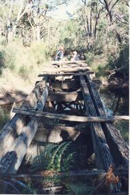 Halls Gap & Grampians Historical Society
Photograph - Coloured
An old bridge on the Heatherlie Quarry rail line at Back Creek, this line was used to transport sandstone from the quarry to Stawell.Photo shows an old bridge with 3 adults at the end, one male standing and 2 adults sitting. The bridge consists of large wooden beams,cross beams and supports .water can be seen at the bottom of the depression. Bush surrounds the bridge.structures, bridges -
 Eltham District Historical Society Inc
Photograph, Monash Bridge, Arthurs Creek Road, Hurstbridge, Eltham Heritage Tour, 24 May 1992, 24/05/1992
ELTHAM HERITAGE TOUR The Society excursion on 24th May 1992 was arranged by David Bick, leader of the team carrying out the Shire's heritage study. David selected a number of sites or buildings identified in the study, some of them lesser known components of the Shire's heritage. The tour commenced at the Eltham Shire Office at 10.00 am. Travel was by private car and mini-bus with stops at about twelve locations for commentary by David.It included a short walk in Hurstbridge and lunch at Kinglake. Highlights of the tour included: - 10 am Leave from Shire Offices - 3 Important Trees - A Physical Link to Eltham's First Settlers - Toorak Mansion Gates - A Surviving Farm House - An Intact Circa 1900 Main Street - First Settlers - Gold Miners, and Timber-getters - An Early Hotel - A Pioneering Homestead - Changing Eltham Shire - 20th Century - 4 pm Afternoon Tea and Finish Tour Extract from ELTHAM CULTURAL HERITAGE TOUR (Newsletter No. 85, July 1992, by Bettina Woodburn) "On the Arthurs Creek Road is a bridge designed by Monash, which we admired before walking across the little park with a mud-brick and timber shelter, to the Hurst family graveyard. There are two marked graves, one, Henry who was shot by Burke the bushranger and a cairn has a plaque listing others buried here from 1866 onwards. Burke was captured and tied to the wheel of a dray under the eucalypt near the waterhose/standpipe. Close by the kindergarten, at this place are three trees on the National Trust Register, a Canary Island pine, a Canadian cedar and probably a spruce. Radiata pines and a thick bolled peppercorn surround the little cemetery. Continuing along Main Street we notice elm trees planted as a war memorial, then on the left a 1930 timber house, a 1910 store and residence, resplendent with wrought iron trim, a double fronted Hardware Store and cypresses on the back alignment of a new vacant block. On the right side of the street is a less interesting attempt at an 'in character' shop. Further on are more early homes, one tucked away at the rear with two tall palms by the front steps. Another curiosity is a rounded veranda corner and there are more galvanised iron sheds or garages, before a mud-brick Dentist's Surgery. Beyond the round-a-about is St Peters Church, of mud-brick construction shared by Catholic and Anglican parishioners, overlooking the river flood plain. Leaving Hurstbridge on the Kinglake Road, we ate our picnic lunch beside the communication tower and enjoyed views of Melbourne, Yan Yean Reservoir and the distant Dandenongs beyond the spreading suburbs. Next we drove to the North West boundary of the Shire at Masons Falls Road towards Whittlesea. On the way to the North East Boundary we passed St Peters, a yellow wooden Church with a Tudor Archway; built in the early 1920's in the style of the 1860's. From the Healesville-Kinglake road the rolling hills had European aspects, the hedged fields and chestnut trees. Then it was back down the Hurstbridge Road through 'Aussie' bush of towering gums, with bracken and scrubby understorey, the Kinglake National Park, before more open country with deciduous trees planted in line, and a creek lined with willows."Record of the Society's history and activities and highlighting various aspects of the Heritage Study undertaken by David Bick used to create the future heritage overlay for the Shire of Eltham and later Nillumbik Shire.Roll of 35mm colour negative film, 4 stripsKodak Gold 100 5095shire of eltham historical society, activities, heritage tour, hurstbridge, monash bridge, arthurs creek road -
Phillip Island and District Historical Society Inc.
Photograph
Phillip Island Suspension Bridge - 1st road connection between Phillip Island and the mainland at San Remo 1938. Part of an album compiled and donated by Mrs Helen Jansson.Phillip Island Suspension Bridge.Descriptive caption adjoining this photo print, also the previous one.local history, photography, photographs, slides, film, civil engineering, bridges, phillip island bridge, black & white photograph, mrs. helen jansson, suspension bridges, phillip island -
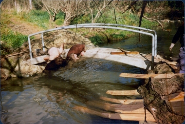 Darebin Parklands Association
Installing Clifton Bridge, 1979-1980
The bridge was designed and constucted by Sidney Clifton (pictured), an engineer who lived in a house neighbouring the parklands.Colour photograph. Two men inspecting the underside of the bridge. The remnants of the wooden frame used to set the concrete bridge can be seen on the right hand side. -
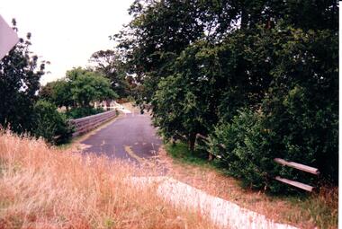 Hume City Civic Collection
Photograph, c 1980s
The stone bridge was the only entry into Sunbury on the eastern side of the town and was in use until the road was re-routed and widened in the 1970s.A coloured photograph of the roadway over the Macedon Street bridge which spans Jacksons Creek. There is a grassy area in the foreground with trees growing either side of the bridge. The narrow asphalted surface of the road across the bridge is cut off by a low stone wall.stone bridges, jacksons creek, macedon street road bridge, george evans collection