Showing 2124 items matching " john hall"
-
 Mt Dandenong & District Historical Society Inc.
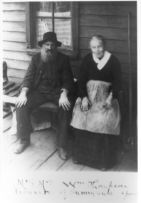
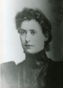
Photograph, Mr and Mrs William Thompson At Sunnyside
Mr and Mrs William Thompson, owners of Sunnyside at South Sassafras from 1893 until 1910 when they sold the property to John and Roberta Roberts. Seated on the verandah.Mr and Mrs William Thompson. Memento of Sunnyside fromwilliam thompson, sunnyside, south sassafras -
 Mt Dandenong & District Historical Society Inc.
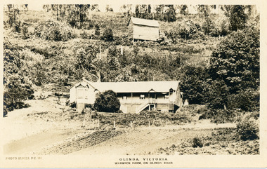
Photograph, Warwick Farm On Olinda Road
Information supplied by Stephen Trembath. Warwick Farm was established by my late grand parents Polly (nee Mary Ann Cole) and George Barratt and their 5 children George Jnr, William, James, John (my maternal Grand Father) and Teddy. Their story is told in a book "The wine of Courage" written in 1977 by N.M. Roberts ISBN 0 7223 1003. Their story started when their bank closed their doors on 13 April 1893 and they lost their cafe business in South Melbourne. Two days later, they were ready to head for a new start in Queensland when they saw in the morning paper that the Dandenong Ranges had been thrown open to land release to people. A few days later, having been granted land they headed to Ferntree Gully. From there they walked to the new holding in what would become Olinda. Then George with his sons help had to build a shelter for the family for the night. They chose to name the property "Warwick Farm". Work on the house started a few days later with help from neighbours Mr. Dodd, Mr Beattie, the O'Sheas and others. Come November, Ruby was born. Then bushfire burnt down the newly built house. Back to a bark hut until another house could be built. The new house became a guest house at the suggestion of a neighbour, when George couldn't sell timber and was waiting for crops. The first guests visited in 1898 and another baby, Percival, was born. ....................................................... It was George's son Jim, who was a skilled carpenter and axeman who extended the home to take from 12 to 30 guests. In 1950 Warwick Farm became the home of distinguished writer and journalist C.E.Sayers for a number of years.Photo Series Pictorial Postcard # 981 showing the property Warwick Farm on Olinda Road.Printed on back: PHOTO SERIES Pictorial Postcards. Published by S. Jamieson Bros. Alphington Vic. Phone Northcote 60warwick farm, olinda, postcard, photo series, olinda road, george barratt, barratt, guest house, guest house -
 Mt Dandenong & District Historical Society Inc.
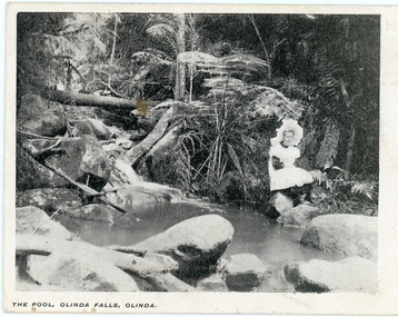
Photograph, The Pool, Olinda Falls, Olinda
"Punch" Postcard depicting a girl in a white pinafore and large, white hat sitting on a rock beside a water. Tree ferns are the backdrop. The front inscription on the postcard is The Pool, Olinda falls, Olinda.The same image appears in a photograph in the John Lundy-Clarke Collection where the girl is identified as Jessie Wyles and the location Emerald Creek.Printed on front of postcard: The Pool, Olinda Falls, Olinda.olinda falls, olinda, jessie wyles, postcard -
 Mt Dandenong & District Historical Society Inc.
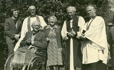
Photograph, Iris Woolrich With Church Officials, c1980
Iris Woolrich with a group of Church officials. L to R: Rev Stephen Coggins, Padre Frank Oliver, Rev A.C. Miles (wheelchair), Iris Woolrich, Archbishop Woods, Mr John Spicer (diocesan lay reader). c1980Handwritten on reverse with green pen: L to R: Rev Stephen Coggins, Padre Frank Oliver, Rev A.C. Miles (wheelchair), Mrs. Iris Woolrich, Archbishop Woods, Mr John Spicer (diocesan lay reader). iris woolrich, rev stephen coggins, padre frank oliver, rev a. c. miles, archbishop woods, mr john spicer -
 Mt Dandenong & District Historical Society Inc.
Photograph, Workers at Range View Nursery, 1950s
Iris and Ted Woolrich pose with a group at Range View Nursery in the 1950s. Bagged rhododendrons at the front. L to R: John Jaggers, Henk Koelwyn, Ted Woolrich, Iris Woolrich & Alice.Handwritten on the reverse in pencil: John Jaggers, Henk, Ted, Alice & Irisiris woolrich, ted woolrich, range view nursery, henk koelwyn, john jaggers, olinda, rhododendron -
 Mt Dandenong & District Historical Society Inc.
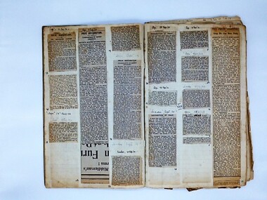
Scrapbook, John Valantine's Scrapbook, c1922
John Valantine collected and pasted newspaper cuttings about Mt Dandenong and Kalorama into a scrapbook covering the period from approx 1922 - 1937. Much of the information dealt with the difficulties faced by local fruit growers so John Valantine may also have been a fruit grower. It is also possible that John himself wrote many of the items as from July 15th, 1930, he was appointed a local correspondent for The Age newspaper...John Valantine lived in Farringdon Road, Kalorama. In the 1920s and 1930s he was also the secretary of the Reserves Committee.Rectangular scrapbook with mottled red/grey cardboard cover. Thirty-one double sided pages with newspaper cuttings pasted in covering the years 1922 - c1937.john valentine, scrapbook, reserves committee, kalorama, berry growers, mt dandenong -
 Mt Dandenong & District Historical Society Inc.
Photograph, Hubert Child
Bert Child son of Francis Matthew father of Jack, Bert and Len. Husband of Maria Madden. Died 1926.Black and white photograph of Bert Child as a young man. He is sitting in the grass near a wooden building. This photograph has a detailed inscription on the back handwritten by John Lundy-Clarke.Bert Child son of Francis Matthew father of Jack, Bert and Len. Husband of Maria Madden. Died 1926.bert child, hubert child, francis matthew child, maria madden, kalorama -
 Mt Dandenong & District Historical Society Inc.
Photograph, James Madden
James Madden was the father of Ethel (Mrs. Edward Child) and Maria (Mrs. Bert Child).Black and white photograph of James Madden. He is middle aged, bearded and wearing a suit. He has a walking stick in his right hand. This photograph has a detailed inscription on the back handwritten by John Lundy-Clarke.James Madden father of Maria and Ethel Madden.james madden, ethel madden -
 Mt Dandenong & District Historical Society Inc.
Photograph, Harry Child's Hut, early 1900s
Home of Harry Child in foreground built on the southern boundary of his father's (Francis Matthew Child) allotment. Black and white photograph showing the home of Harry Child. This photograph has a detailed inscription on the back handwritten by John Lundy-Clarke.The eastern face of Mt Dandenong from F.M. Childs selection Cnr allotment D.francis matthew child, mt dandenong, harry child -
 Mt Dandenong & District Historical Society Inc.
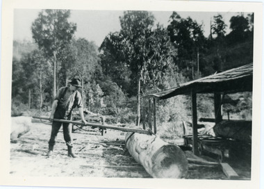
Photograph, Percy Child, c1910
Percy Child was the son of Francis Matthew (Frank) Child whose father Mathew Child was one of the first three settlers in the area. Percy ran the Child Bros. Sawmill with his brother Harry.Black and white photograph showing Percy Child using a cant-hook at Child Bros. Sawmill. This photograph has a detailed inscription on the back handwritten by John Lundy-Clarke.Charles Percival Child (Sammy) about 1910percy child, harry child, sawmill, kalorama -
 Mt Dandenong & District Historical Society Inc.
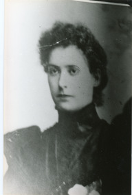
Photograph, Jeannie Green
Jeannie Green from Wandin married Willie Richardson (son of the original settler Jabez Richardson) in 1898. They built a home in the Kalorama Valley and named it "Mt Calvin". Jeanie had three children - Reuben born 1890, William born 1901 and Jean born 1910. Jeanie suffered ill health and required assistance with cooking and cleaning. The family left the area in search of a warmer climate for Jeanie.Black and white studio portrait of a young Jeannie Green wearing a high necked dress.Jeanie Green (Mrs J W Richardson) born 1871 died 1916. Mother of Reuben, William, Jean.jeannie green, jeanie green, willie richardson, john willie richardson, rueben richardson, william richardson, jean richardson, mt calvin -
 Mt Dandenong & District Historical Society Inc.
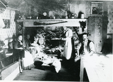
Photograph, Harmony Vale kitchen c1895, c1895
Inside the kitchen of Harmony Vale the home of Jabez Richardson and family taken c1895. Jabez Richardson and his wife Sarah Ann are seated in the chimney ingle. Daughter Martha sits at the end of the table on LHS while daughter Sarah Ann tends the pot. Son John Willie sits smoking his pipe.harmony vale, richardson, jabez richardson, john willie richardson, martha richardson, sarah ann richardson, kitchen, cooking, chimney -
 Mt Dandenong & District Historical Society Inc.
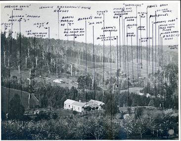
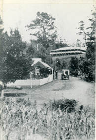
Photograph, "Kia-Ora' Guest House. Kalorama Valley c1900, c1900
Landscape view from Barbers Road across the valley. Kia-Ora was built by George Barber in 1909 and run as a guest house. John Lundy-Clarke annotated the properties shown with the owners' names. Excellent companion piece to J L-C's "Mountain of Struggle".kalorama valley, kia-ora guest house, mountain of struggle, john lundy-clarke -
 Mt Dandenong & District Historical Society Inc.
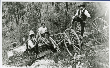
Photograph, The Wagonette Disaster 27th December 1911, 1911
This accident occurred at Devil's Elbow where now the Old Coach Road and Jasper Road meet at a cliff face. John Lundy-Clarke wrote a ballad about the mishap, probably combining fact and fancy. The wagonette was returning from an excursion to the Brooklyn Guest House in Montrose. Apparently only the horses were killed in the accident. See 'The Brooklyn Dray". The photograph shows local men inspecting the wreckage. (Not passengers as they were injured).devil's elbow, kalorama, john lundy-clarke, wagonette -
 Mt Dandenong & District Historical Society Inc.
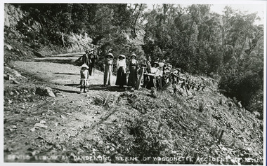
Photograph, Devil's Elbow at Mt Dandenong Scene of Waggonette Accident 27.12.11, 1911
Accident occurred at Devil's Elbow where now the Old Coach Road and Jasper Road meet at a cliff face. John Lundy-Clarke made a ballad about the mishap. The waggonnette was returning from an excursion to the Brooklyn Guest House in Montrose. The horses were killed and passengers presumably injured (a doctor attended). See 'The Brooklyn Dray".john lundy-clarke, kalorama, devil's elbow, wagonette -
 Mt Dandenong & District Historical Society Inc.
Photograph, Jeeves Coach on CRB Road at Foot of Farringdon Road Kalorama, 1920, 1920
Scene looking down Farringdon Road showing Jeeves horse drawn coach going along the CRB road (Mt Dandenong Tourist Road) in 1920. Detailed inscription on the back handwritten by John Lundy-Clarke in 1974.Jeeves Coach on CRB road at foot of Farringdon Road Kalorama (Mt Dandenong North) 1920. Road was formed most of the length from Montrose by contractors Bladin and Dick employing Robert Logan the younger, in 1919 and lay unmetalled till metalled by the contractors in 1922. Mountain ash trees in foreground were on Thomas Hand’s original 23 acre holding. Those beyond coach were on Isaac Jeeves original 160 acre holding Selection Crown Allotment 925(B). This was the area forming part of the inheritance lost by John William Richardson because of the expense of his wife’s illness. Hand enlarged his 23 acres to 305 in 1874. William and his family grew large crops of raspberries on his area, part of which is in the foreground. It had been cleared by his father’s employees before 1877. The section below the Main Road was cultivated by Fred hand, son of William and grandson of Thomas in the twenties before he moved to Redcliffes where he is today (1974). Comment by John Lundy-Clarke 10.5.1974 coach service, jeeves, crb road, farringdon road, kalorama, mt dandenong north, mt dandenong tourist road, john lundy-clarke, coach -
 Mt Dandenong & District Historical Society Inc.
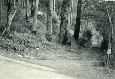
Photograph, Jasper Road Near Erith Lane 1920, 1920
View of Jasper Road, near Erith Lane taken in 1920. The road is tree lined with two significant gum trees in the foreground. This photograph has a detailed inscription on the back handwritten by John Lundy-Clarke in 1974.Jasper Road near Erith Lane 1920. This road has only a narrow right of way. It was put in as a road to serve “Cherry Farm”, connecting it to the Coach Road at the Elbow in 1904. It joins a wide surveyed road running from Inverness Road to the Coach Road at the Elbow and could possibly have been surveyed by Thomas Hand at the same time as Inverness Road. The name Jasper now applies to full length between Erith Lane and Coach Road. McGivern Bros widened it in 1937 and J L Clarke removed and stored much of the rock quarried in the widening. This was later sold to Dick Moorby who sold it to the builders of St Michaels Church in Falls Road. Comment by John Lundy-Clarke 10.5.1974 jasper road, erith lane, john lundy-clarke -
 Mt Dandenong & District Historical Society Inc.
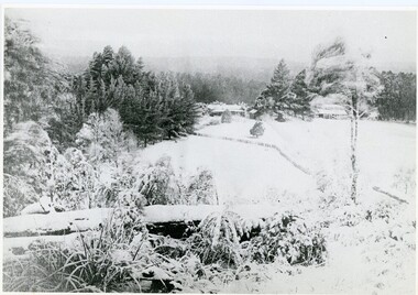
Photograph, A View Over Mountain Grange 1921, 1921
A view of Mountain Grange Homestead built by Thomas Hand with buildings and ground covered in snow. The photograph has historical information on the back handwritten by John Lundy-Clarke in 1976.1921 A view over “Mountain Grange” from the side of Mt Kalorama above where Grange Road is now. On the left of the homestead is the avenue of pine trees under which the annual Sunday School picnic was held. On the right is the giant pine that still stands (1976) and the great barn. The separate kitchen of the homestead can be clearly seen. mountain grange, snow, john lundy-clarke, thomas hand -
 Mt Dandenong & District Historical Society Inc.
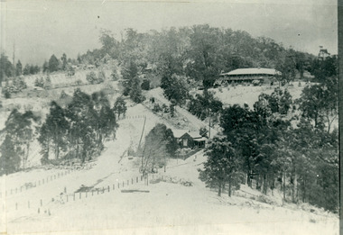
Photograph, Post Office and 'Mountjoy', Mt. Dandenong North, 1913
Rose Series post card #182Copy of Rose Series postcard #182 showing Kalorama Gap in 1913. Haystacks in foreground with Mountjoy Guest House and Beulah Tea Rooms/Mt Dandenong North Post Office in centre. This photograph has a detailed inscription on the back handwritten by John Lundy-Clarke in 1974.Kalorama Gap in 1913 The elm trees are in the centre of the picture. One of these is really two as two suckers of the further tree were twisted together by Fred Jeeves in 1898 and grew as one tree. The other was planted in 1880. The shop is the shop of Mrs Eliza Hand and daughter Florence. The closed in far end of the verandah was the Mount Dandenong North Post Office. The large house is “Mountjoy” owned and run by the Jeeves Family from 1908 till 1943. It was built in 1905 by the Paynters who sold to Ellis Jeeves in 1908.He moved his line of coaches from “Kalorama” his old homestead and housed the horses in a line of stables behind “Mountjoy”. Price’s house, which contained their shop, the first one on the mountain, opened 1906, can be seen faintly behind the pine tree opposite the bend in the road, which was the main road then and now is Ridge Road. The Price’s house just shows in two tiny pieces, one on each side of the pine tree half way up. The house to the right of and high up the pine tree is Walker’s cottage which exists today opposite Jack Kidd’s home at the far edge of Lt 2 Village Settlement and was between Main Road and Barbers Road which runs down the left behind the elms. Walker’s homestead can be seen near left edge of picture 2/3 way up. The roof of the Methodist Church shows among trees left of picture. This, like Mrs Hand’s shop was built on portions separated from Isaac Jeeves’ Selection “C” known as Jeeves Saddle. kalorama gap, five ways, mountjoy, john lundy-clarke, beulah tea rooms, post office, fred jeeves, paynter, jeeves, frederick jeeves, price, walker, jack kidd -
 Mt Dandenong & District Historical Society Inc.
Photograph, View from 'Forest Edge', 1973
Photograph taken in 1973 from the property 'Forest Edge', the home of early settler George Barber. This photograph has a detailed inscription on the back handwritten by John Lundy-Clarke in 1973.Taken November 1973 by JLC. View looking from “Forest Edge” George Barber’s old home towards Price’s Lot 18. Gap on right skyline. Broadways house centre on Lot 18. Lot 25 in foreground recently cleared by Merchant Builders. Kia Ora site centre left. forest edge, george barber, price, kia ora -
 Mt Dandenong & District Historical Society Inc.
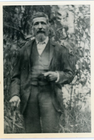
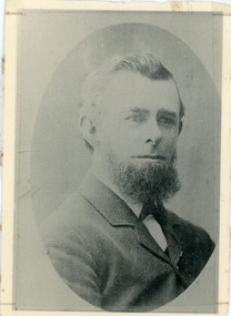
Photograph, Thomas Hand 1839-1888
Copy of a formal photograph showing head and shoulders of Thomas Hand, 1839-1888. This photograph has a detailed inscription on the back handwritten by John Lundy-Clarke in 1974.Thomas Hand 1839-1888 Surveyor for Upper Yarra Road Board 1862-1872. Engineer for Shire of Lillydale 1872-1888. Father of Kate, Eva, Eliza, Florence, Mabel, Alice, Frederick and William. Married Eliza Erith 1862. Owner of “Mountain Grange” in the present district of Kalorama. Copy of photograph in possession of his daughter Mabel made by JLC in 1974. thomas hand, mountain grange -
 Mt Dandenong & District Historical Society Inc.
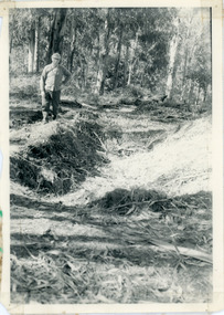
Photograph, Pit Silo 1974 view, 1974
Photograph taken in 1974 showing John Lundy-Clarke standing beside the pit silo he dug in he 1920s on Dunbar's Lot 20 of the Village Settlement. The pit silo was to hold cut maize to turn into silage for a food supply for the cows in the winter.A 1974 view of the pit silo and its maker at Lot 20 of the Village Settlement (Dunbar’s lot) The trees in the background cover the landslide of 1891-1934.pit silo, john lundy-clarke -
 Mt Dandenong & District Historical Society Inc.
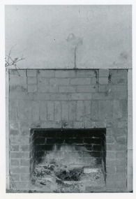
Photograph, Open Fire Place in Worker's Cottage, 1972
Photograph taken in 1972 showing an open fire place built of recycled brick in a worker's cottage. This photograph has a detailed inscription on the back handwritten by John Lundy-Clarke in 1974.Open fire place in workers cottage built of bricks from house built for John William Richardson 1897. Chimney built for Rowses by J. Lundy-Clarke May 1938. Picture taken 18-11-72 Richardsons house was pulled down by Rowse Bros. 1937-8. fireplace, richardson, rowse, john lundy-clarke -
 Mt Dandenong & District Historical Society Inc.
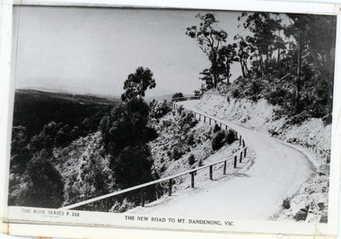
Photograph, The New Road to Mt. Dandenong, Vic
Copy of Rose Series postcard #332Copy of Rose Series postcard #332 showing a windy bend on the new road c1924. This photograph has a detailed inscription on the back handwritten by John Lundy-Clarke in 1974.The Windy Bend in 1924. Landslide of 1971 occurred at lower right hand corner.mt dandenong road, rose series, windy bend, landslide -
 Mt Dandenong & District Historical Society Inc.
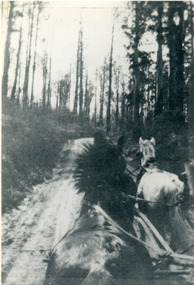
Photograph, View From Seat of Jeeves Coach, c1921
View the driver would have from horse drawn coach. CRB (Main) Road between Wombat Road and Falls Road. c1921. This photograph has a detailed inscription on the back handwritten by John Lundy-Clarke in 1974.View from seat of Jeeves Coach over horses while being driven along the new CRB road between Wombat Road and Falls Rd 1921.wombat road, falls road, crb road, jeeves coach, horse -
 Mt Dandenong & District Historical Society Inc.
Photograph, Jeanie Richardson
Photograph of studio portrait taken of Jeanie Richardson, wife of John William (Willie) Richardson, who was the son of Jabez Richardson an early pioneer of the area. This photograph has a detailed inscription on the back handwritten by John Lundy-Clarke.Jeanie Richardson nee Green. Born 1871. Died 1916. Mother of Reuben, William, Jean. Copy of photo held by Reuben Richardson of Roma. richardson, jeanie richardson, reuben richardson, jabez richardson -
 Mt Dandenong & District Historical Society Inc.
Photograph, The Gap Under Snow 1921, 1921
Snow scene looking up through The Gap (FiveWays) with Mountjoy Guest House on the hill to the right. The shop and post office are seen in the centre of the picture. This photograph has a detailed inscription on the back handwritten by John Lundy-Clarke in 1974.The Gap under snow 1921. “Mountjoy” on hill. New CRB road formation (unmetalled) comes into picture lower left corner, passes left of dray under the elms, then circles around behind the trees behind Miss Hands shop and home and Post Office (Mt Dandenong North) to pass out of picture left in centre of picture. It passes between Ted Prices Hay & Corn store and Walker’s house where the Estate Agency was later placed. Main Road then in centre of picture bend right behind Mountjoy. Price’s house and shop behind the blackwood left of road bend. CRB cuts across Barbers left of Elm trees.john lundy-clarke, kalorama, mountjoy, mountjoy, the gap, post office, mt dandenong north, snow -
 Mt Dandenong & District Historical Society Inc.
Photograph, The Wagon Road, c1970s
The old Wagon Road built 1876-1878. This photograph has a detailed inscription on the back handwritten by John Lundy-Clarke in 1974.The Wagon Road. Built 1876 – 8. The first settler’s road in the Ranges as apart from Dray Tracks. Was built through Jeeves Selection, Crown Allotment “C” named “Jeeves saddle” and removed the monopoly held over travel through the Gap. jeeves saddle, kalorama, road, wagon road, john lundy-clarke -
 Mt Dandenong & District Historical Society Inc.
Photograph, The Gap at Kalorama 1913, 1913
1913 scene looking up to Mountjoy Guest House at the Kalorama Gap (FiveWays). Post Office and tea rooms with white picket fence. Jeeves Coach on the road. This photograph has a detailed inscription on the back handwritten by John Lundy-Clarke in 1974. The Gap Kalorama 1913. ‘Mountjoy’ guest house. Mount Dandenong North Post Office. Jeeves coach.fiveways, mountjoy, post office, mt dandenong north, the gap, jeeves, coach -
 Mt Dandenong & District Historical Society Inc.
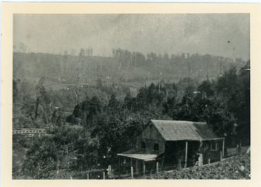
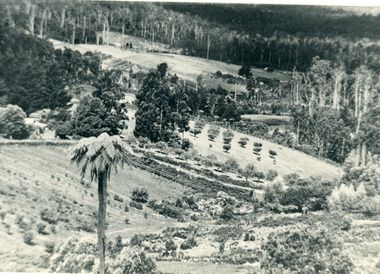
Photograph, The Valley of the Harmony Vale Settlement c1910, 1973
Scene looking across the valley of Harmony Vale from Barbers Road. c1910. Photograph copied by John Lundy-Clarke in 1973. This photograph has a detailed inscription on the back handwritten by John Lundy-Clarke in 1974.The valley of the Harmony Vale settlement on the Olinda Creek from Barbers Road. "Shiloah" on far left centre. John William Richardson's home among trees left of centre. Homestead Harmony Vale above log yard (see below) and among orchard trees. Child Bros sawmill and log yard with logs among trees above flat cultivation right of centre. Bert Childs home beyond "Harmony Vale". Lucas' "Glenrivers" is in gully above main clearing centre top left. Frank Childs home among trees centre of picture. Taken about 1910 by Rose Series. Copied 1974 JLC.kalorama, harmony vale, olinda creek, barbers road, shiloah, sawmill, child, bert child, glenrivers