Showing 11126 items
matching planning
-
 Bendigo Historical Society Inc.
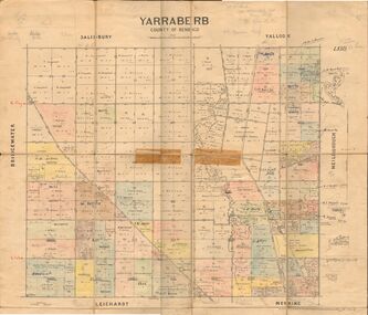
Map - JACK FLYNN COLLECTION: YARRABERB, 2/03/1931
Map: Yarraberb, County of Bendigo. Parish plan.By Authority H.J. Green Govt., Printer. Photo Lithographed at the Department of lands and Survey Melbourne, 2.3.31.map, bendigo, parish plan, yarraberb -
 Bendigo Historical Society Inc.
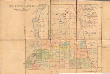
Map - JACK FLYNN COLLECTION: BRIDGEWATER, 6/10/1927
Map: Bridgewater , County of Bendigo. Parish plan.Photo Lithographed at the Department of Lands and Survey, Melbourne by W.J. Butson.map, bendigo, parish plan, bridgewater -
 Bendigo Historical Society Inc.
Map - COLBINABBIN, June 1951
Map: Colbinabbin, County of Rodney. Parish planmap, rodney, parish plan, colbinabbin, county of rodney -
Bendigo Historical Society Inc.
Map - TARNAGULLA SHEET 2, No date Visible
Map: Tarnagulla Sheet 2, Parish planmap, parish plan, tarnagulla -
 Bendigo Historical Society Inc.
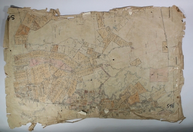
Map - SANDHURST SHEET 3, June 29th 1967
Map: Sandhurst sheet 3. Parish plan.map, bendigo, city streets, sandhurst, early bendigo -
 Bendigo Historical Society Inc.
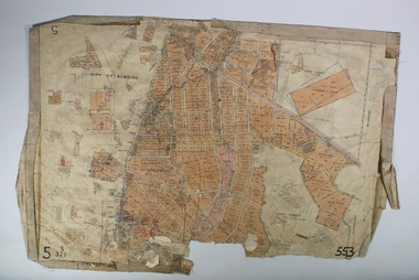
Map - SANDHURST SHEET 2, March 12th 1867
Map: Sandhurst sheet 2 . Parish plan.map, bendigo, city streets, sandhurst, early bendigo -
University of Melbourne, Burnley Campus Archives
Document, Burnley: Celebrating 125 years of Horticultural Education 1891-2016, 2015
Planning notes for activities for 2016. 5 pp.burnley, horticultural education -
University of Melbourne, Burnley Campus Archives
Document, Orchard Development Plan, c. 1983
Plan to redevelop orchard, including greenhouse areaorchard, greenhouse -
University of Melbourne, Burnley Campus Archives
Document, Lesson plans, 1967
Lesson plans of G.D. Grumont and I.D. McLureburnley horticultural college, lesson plans, g.d. grumont, i.d. mclure -
Clunes Museum
Plan - ARCHITECTS PLANS, DARYL JACKSON REPORT PTY. LTD
SKETCH DESIGN REPORT - WESLEY AT CLUNESARCHITECTS PLAN WESLEY AT CLUNES. DARYL JACKSONlocal history, document, plans, education, schools, wesley -
Stawell Historical Society Inc
Map, Gold Mines of Australia, Gold Mines of Australia underground workings. Newington Rd Darlington Rd Area 1950, 1950
Plans Showing Surveys & Drilling Stawell InvestmentGold Mines of Australia Stawell Investment 2003 mining, gold, map -
 Whitehorse Historical Society Inc.
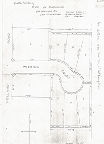
Document, Walter Wicking Plan of Subdivision, ?1952
Plan of subdivision for Wicking CourPlan of subdivision for Wicking Court, South Blackburn.Plan of subdivision for Wicking Courland subdivision, wicking court, blackburn south, wicking, walter benjamin, holland road -
 Whitehorse Historical Society Inc.
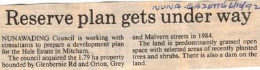
Article, Reserve plan gets under way, 6/10/1992 12:00:00 AM
Article on the development planArticle on the development plan of the Hale Estate, Mitcham.Article on the development planhale estate, mitcham, glenburnie road, orion street, vermont, grey street, malvern street, land subdivision -
Whitehorse Historical Society Inc.
Document, Wandinong Sanctuary Management Plan, 2000?
Wandinong Sanctuary Advisory Committee Management Plan.Wandinong Sanctuary Advisory Committee Management Plan.Wandinong Sanctuary Advisory Committee Management Plan.wandinong sanctuary, wandinong sanctuary advisory committee, ellemor, w r, nechwatal, janine -
Whitehorse Historical Society Inc.
Document, Types of timber-framed dwelling houses, 1920s
Two plans of two bedroom weatherboard houses.Two plans of two bedroom weatherboard houses.Two plans of two bedroom weatherboard houses.californian bungalows, weatherboard -
Whitehorse Historical Society Inc.
Pamphlet, Masonite Home plans, 1950s?
Home plans by Masonite, a local manufacturer in Whitehorse.Home plans by Masonite, a local manufacturer in Whitehorse.Home plans by Masonite, a local manufacturer in Whitehorse.houses, building industry, mitcham -
 Whitehorse Historical Society Inc.
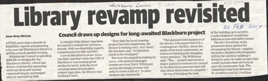
Article, Blackburn Library Revamp, 2017
Whitehorse Council is planning a revamp of the Blackburn library.libraries, city of whitehorse, blackburn -
 RMIT Design Archives
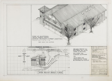
Architectural drawings, Proposed Extension to Boatshed for Melbourne University Sports Union
Site Plan and View from North-Westink, acetate -
Stawell Historical Society Inc
Map, Section 3 (Taken from Plan No 959), 1894
Section 3 (Taken from Plan No 959)stawell -
Stawell Historical Society Inc
Map, Section 2 (Taken from Plan No 959), 1894
Section 2 (Taken from Plan No 959)stawell -
Stawell Historical Society Inc
Map, Section 4 (Taken from Plan No 959), 1894
Section 4 (Taken from Plan No 959)stawell -
Stawell Historical Society Inc
Map, Section 5 (Taken from Plan No 959), 1894
Section 5 (Taken from Plan No 959)stawell -
University of Melbourne, Burnley Campus Archives
Plan, Classroom Locations Map, 1990-2000
Plan produced by VCAH Burnley with classrooms marked.vcah, burnley -
 University of Melbourne, Burnley Campus Archives
Plan, Nursery
nursery -
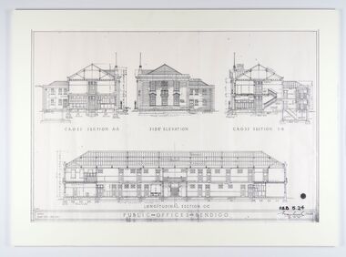 City of Greater Bendigo - Civic Collection
Work on paper - Architectural Drawing, City of Bendigo, Public Offices Bendigo, 23 November 1928
Mounted plan drawings for Public Offices in Bendigo.Cross Section A-A / Side Elevation / Cross Section B-B / Longitudinal Section C-C / R.M.B. / Scale: Eight feet - One Inch / PUBLIC OFFICES BENDIGO ? P.B.B. 5.24 / (signature) / Chief Architect / 23.11.24city of greater bendigo administration item -
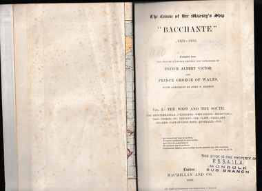 Mrs Aeneas Gunn Memorial Library
Book, McMillan and Co et al, The cruise of Her Majesty's ship Bacchante, 1879-1882 v.1, 1886
A description of a world cruise taken by Prince Albert Victor and Prince George of Wales.Ill, charts, maps, plans, p.675.non-fictionA description of a world cruise taken by Prince Albert Victor and Prince George of Wales.australia - description and travel, voyages around the world -
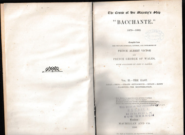 Mrs Aeneas Gunn Memorial Library
Book, McMillan and Co et al, The cruise of Her Majesty's ship Bacchante, 1879-1882 v.2, 1886
A description of a world cruise taken by Prince Albert Victor and Prince George of Wales.Ill, charts, maps, plans, p.803.non-fictionA description of a world cruise taken by Prince Albert Victor and Prince George of Wales.australia - description and travel, voyages around the world -
Port Melbourne Historical & Preservation Society
Plan - Extension to weighbridge, Sandridge, George Kelly?, Borough Surveyor, 8 Nov 1864
Plan for extension of weighbridge, Borough of Sandridge, 1864.Numbered in red pencilengineering, borough of sandridge - engineering department, george kelly -
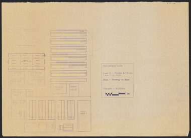
 Bendigo Historical Society Inc.
Map - SANDHURST,. SHEET ?, 24/04/1907 ?
Map: Sandhurst (sheet No. missing). Parish planmap, bendigo, parish plan, sandhurst -
 Bendigo Historical Society Inc.
Map - SANDHURST, SHEET ?, Date missing
Map: Sandhurst (sheet No., Missing) P_arish planmap, bendigo, parish plan, sandhurst