Showing 26609 items
matching buchan-river-view-hotel
-
 Charlton Golden Grains Museum Inc
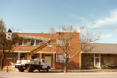
Photograph, Globe Hotel c. 1987, c.1987
Globe Hotel, High St Charlton, established 1874 by John Walsh. This is the third building on the site. The first was destroyed by fire and rebuilt. It was then rebuilt as a two-storey hotel in 1940. It closed as a hotel in the early 1970's and became offices and flats. The Charlton Gentlemen's Club on the RH side was established in 1900. Photo is part of a series of streetscapes taken in 1987 for the Charlton Shire. Globe Hotel third (building) established 1874 as single storeyed and Charlton Gentlemen's Club est. 1900. Globe destroyed by fire and rebuilt in 1940. In 1970's to became offices and flats.Colour photograph of two storey red brick building. Signage on the windows reads SOIL CONSERVATION AUTHORITY (not all words fully visible). A man on a cherry picker in front of building trimming a tree. Signage on the side of the white truck says North Central TRAVEL TOWER Hire. Two orange safety cones on the road. RH side is the single storey, glass-fronted building with a white-framed door. charlton, globe hotel, soil conservation authority, business, industry, agriculture -
 Linton and District Historical Society Inc
Plan, Floor plan of Railway Hotel, Linton, undated
It is not known when the plan was drawn up or by whom.Laminated blueprint, showing 1/8 scale floor and block plan of the Railway Hotel in Sussex Street, Linton. Drawn in white ink on blue paper.railway hotel linton, maps and plans, floor plans -
Malmsbury Historical Society
Photograph (Item), Hotel / Motel, Malmsbury c2000
Buildings - Hotel Associated with - Mollison Street -
 City of Ballarat Libraries
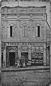
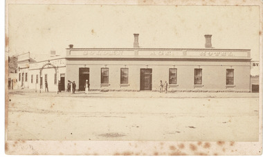
Photograph - Card Box Photographs, Times Hotel, Ballarat 1864
The Time Hotel was located on Bridge Street.time hotel, bridge street, building, hotel -
 Stawell Historical Society Inc
Postcard, Front Cover & the Bull and Mouth Hotel in Main Street Stawell -- 2 Photos -- Postcards -- Coloured
Bull and Mouth Hotel Main Streetstawell streetscape -
 Stawell Historical Society Inc
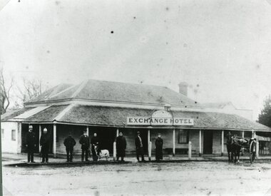
Photograph, Exchange Hotel in Great Western c1870
Exchange Hotel - Great Western c1870stawell -
 Stawell Historical Society Inc
Photograph, Bridge Hotel on the Navarre Road Concongella
Bridge Hotel. Navarre Road Concongellastawell -
 Beaufort Historical Society
Photograph - Beaufort Hotels, Golden Age Hotel Beaufort
Early Photograph of Golden Age HotelBlack and White Photograph on cardbeaufort, beaufort buildings, beaufort hotels -
Lakes Entrance Historical Society
Postcard - Black Hills Deddick, WPT series, 1908 c
Letter on back to Miss Evans of Linia East via BenallaHand coloured postcard showing view of Black Hills Deddick VictoriaThe Black Hills Deddick near Buchantopography -
 Malmsbury Historical Society
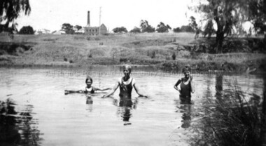
Photograph (Item), B/W Children Swimming In Coliban River, Malmsbury c1934
Buildings - "Coliban River, Mill" -
 Federation University Historical Collection
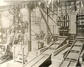
Photograph - Black and White Image, Interior View of the Ballarat School of Mines Battery, c1901-1920
The Ballarat School of Mines Model Mine was used to give practical experience to students, as well as to conduct assays for companies and individuals for a fee. The fee assisted in keeping the Ballarat School of Mines afloat in its first years. The Battery, or model mine, included a Stamper Battery, Wilfrey Tables and various pieces of equipment students would encounter in their workplace. Steam engines were used to operate the large pulleys depicted in the photograph which in turn ran the equipment.Interior view of the Battery in the Ballarat school of Mines Model Mine. ballarat school of mines battery, model mine, stamper battery, steam, pulley, ballarat school of mines, battery house -
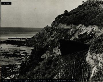 Lorne Historical Society
Photograph, The Cutting near Clarke's at Eastern View
Photograph of the cutting, fence and road near Clarke's at Eastern Viewg.o.r eastern view: cutting near clarke's: fencing: -
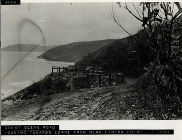 Lorne Historical Society
Photograph, View from Big Hill looking towards Lorne
Photograph of view of Lorne from Big Hill circa 1923big-hill, lorne: 1923 -
 Ringwood and District Historical Society
Photograph, View from Loughnan Road towards centre of Ringwood - undated
View from Loughnan Road towards centre of Ringwood - undated. -
 Buninyong & District Historical Society
Photograph - Original Photograph, Front view Netherby, Warrenheip St. in 1991, 1991
historic, buildingColour photograph, Front view Netherby, Warrenheip St. in 1991buninyong, warrenheip st., netherby, sparling -
 Buninyong & District Historical Society
Photograph - Original Photograph, Larundel homestead, Elaine in 1993, side view, 21/11/1993
historic Colour photo, Larundel homestead, Elaine in 1993, side viewelaine, larundel, austin family -
 Stawell Historical Society Inc
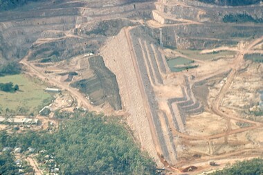
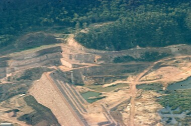
Slide, Ian McCann, Ariel view of the Dam Wall at Lake Bellfield, 1960's
Ariel View of the Dam wall at lake Bellfield Druning Constructiongrampians -
 Stawell Historical Society Inc
Slide, Ian McCann, Ariel View of Lake Bellfied showing the wall, 1960's
Ariel View of Lake Bellfield showing the wall during constructiongrampians, colour slide -
 Stawell Historical Society Inc
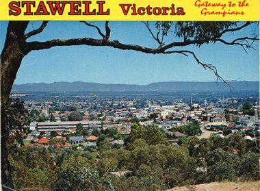
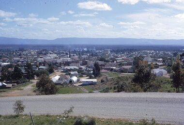
photograph - Slides, Ian McCann, View from Big Hill looing West?, 1976 - 1984
Clour Photograph of the view looking across Stawell towards the Grampians. -
 Whitehorse Historical Society Inc.
Photograph, Front view of St John's Church, 8/10/2002 12:00:00 AM
Coloured photograph of view of the front of the St Johns Church at Westgarthtown,westgarthtown, st johns church westgarthtown -
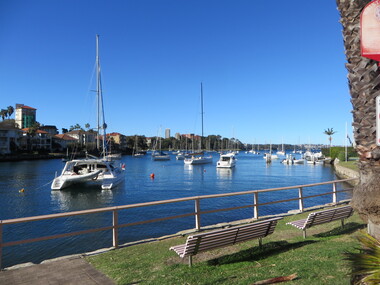 Ballarat Heritage Services
Photograph - Colour, View from the Flying Squadron Club, Kirribilli, 2019, 14/07/2019
Colour photograph of the view from the Flying Squadron Club, Kirribillisydney, flying squadron, kirribilli, sailing -
 University of Melbourne, Burnley Campus Archives
Negative - Black and white negative, Garden View, 1922-1923
Black and white photograph. Garden view across the Croquet Lawnj.l. provan, garden view, croquet lawn -
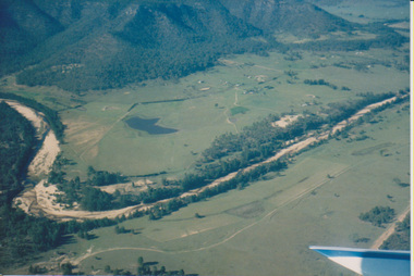 University of Melbourne, Burnley Campus Archives
Photograph - Colour print, Aerial View of Countryside
4 photographs taken from a small aeroplane. Views of countryside.aeroplane, countryside, aerial views -
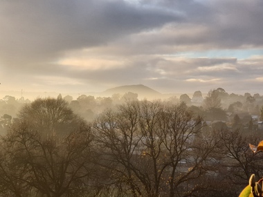 Ballarat Heritage Services
Photograph - Photpgraph - Colour, View Towards Mount Warrenheip, 2019, 20/06/2019
Colour photographs of a view towards Mount Warrenheip on a foggy morning.mt warrenheip, ballarat, fog -
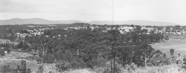
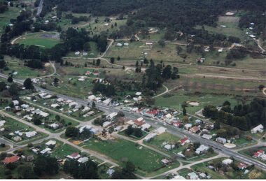 Linton and District Historical Society Inc
Photograph, Photographer: Alan Giles, Aerial View of Linton, 1991, 1.9.1991
Photograph taken by Alan Giles whilst on a joy flight over Linton. Shows oval, left top corner, Sussex St (Glenelg Highway) running from bottom RH corner.Colour photograph, aerial view of Linton township looking north."Linton township, Vic-1st September 1991".linton township -
 Orbost & District Historical Society
black and white photograph, late 19th century / early 20th century
The first settler to occupy the Marlo township area was James Stirling around the year 1875. He built a bark hut on the bluff that had two rooms, bark walls, earthen floors and a shingle roof. By 1884, this structure had expanded to a 9 roomed accommodation house and in 1886 became the Marlo Hotel when a liquor license was granted. The Governor-in-Council declared Marlo to be a township on 18 February 1889. During May 1889, the government surveyor, E.L. Bruce set out 19 sections of the new township, with the first sales of subdivided land occurring the following May. At this time, Stirling's Marlo Hotel was the unofficial hub for the community. It was a general store, accommodation house and the unofficial post office, with settlers taking turns in bringing the mail from Orbost or Cunningham. This continued until Aug 1942, and in 1969 was located in a house adjacent to the Marlo Hotel, before being transferred to the Marlo General Store in this year. The official Post Office List states the Marlo Post Office opened around 1902. in 1925, the "Marlo House" (a nine room accommodation guest house) was granted a liquor licence. The "Marlo House" became "The Marlo Hotel". The Marlo Hotel was popular with many Orbost and district settlers, who travelled to Marlo by horseback or buggy. In the early 20th century the hotel advertised itself as " Under Vice-Regal Patronage. Situated on High Cliff, fronting Ocean, Lakes and Snowy River. Those in search of Health, Rest and Sport should visit Marlo. Boating, Fishing, Shooting, Bathing, Golf. Comfort and Convenience at Marlo Hotel, near Orbost, East Gippsland. Nixon's Cars would meet the train at at Orbost. Fare---6s single, 12s return. Telephone No. 1, Marlo. S, P, STEWART, Proprietor." The Marlo Hotel, perched on the hill overlooking the estuaries and the entrance is a significant building in Marlo. Established in 1886, it has been operating for over 120 yearsAn original black / white photograph and a black / white copy of a party being held under trees on the lawn of the Marlo Hotel. It is a postcard with advertising of Marlo on the back.on back - "Where to spend your holiday - Marlo" on front - "Vice Regal Party at Hotel, Marlo"marlo-hotel -
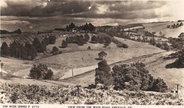 Emerald Museum & Nobelius Heritage Park
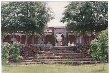
Photograph/postcard, Rose Series Postcards 'View from the Main Road, Emerald, Vic, circa 1930's - 40's
Early panorama of EmeraldPostcard from the Rose SeriesFront: The Rose Series P. 2774 'View from the Main Road, Emerald, Vicrose postcard series, emerald -
 Ringwood and District Historical Society
Photograph, View of forming of ground floor of Target 1981
Written on back of photograph, "6/6/81. View of forming of ground floor of Target." -
 Ringwood and District Historical Society
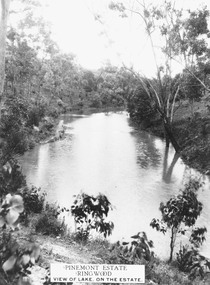
Photograph, Pinemont Estate, Ringwood. View of lake
Label on photograph reads, "Pinemont Estate, Ringwood. View of lake, on the estate". (2 copies) -
 Ringwood and District Historical Society
Photographs, 1979-80 MMBW pipe line project at Hubbard Reserve, North Ringwood � View east from Debbie Place
Part of a 43-photo record of the MMBW�s engineering feat in drilling a 12 inch pipe line up to 40 feet deep through rock hardened by volcanic action associated with geological fault that occurs along the line. The work took place from October 1979 to May 1980 on the southern boundary of Hubbard Reserve, North Ringwood. The collection was presented to the Ringwood Historical Research Group by J Clarke on 9th June 1980.E558 N29 13 May 1980 A43 View east from Debbie Place