Showing 1577 items matching "garden show"
-
 Kew Historical Society Inc
Slide - Hospital wing and Villa Alba's south-facing facade, 1987–2001
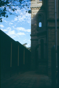
Built for William and Anna-Maria Greenlaw in the early 1880s, and with interiors decorated by the Paterson Bros, Villa Alba remained in private ownership until 1949. From 1950, the house was owned by a number of institutions. By 1984, the Villa Alba Preservation Society had been formed, and three years later, the Mount Royal Hospital granted a 25-year lease to Kew Council. In 2004, the title to Villa Alba was passed by the Victorian Government to The Villa Alba Museum Incorporated. Digital copy of a olour 35mm slide, framed in a plastic mount, of the entrance to Villa Alba, 44 Walmer Street, Kew, 3101. The transparency shows the grey rendered portico, viewed from the east, looking west. At this stage a wing of the hospital abutted the portico. The hospital wing was subsequently demolished and a Victorian era garden reinstated based on an original plan."Villa Alba ext"villa alba museum, historic houses -- kew (vic.), victorian architecture -- melbourne (vic.), mount royal hospital -
 Kew Historical Society Inc
Slide - Rear of Villa Alba with adjacent hospital wing, 1987–2001
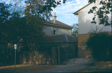
Built for William and Anna-Maria Greenlaw in the early 1880s, and with interiors decorated by the Paterson Bros, Villa Alba remained in private ownership until 1949. From 1950, the house was owned by a number of institutions. By 1984, the Villa Alba Preservation Society had been formed, and three years later, the Mount Royal Hospital granted a 25-year lease to Kew Council. In 2004, the title to Villa Alba was passed by the Victorian Government to The Villa Alba Museum Incorporated. Digital copy of a olour 35mm slide, framed in a plastic mount, of the portico of Villa Alba, 44 Walmer Street, Kew, 3101. The transparency shows the grey rendered rear of the building, viewed from the east, looking west. A two storey wing of the Mount Royal Hospital, facing Nolan Avenue is at the right. The slide shows a set of wire gates separating the east garden of Villa Alba from the main house."Villa Alba"villa alba museum, mount royal hospital, historic houses -- kew (vic.), victorian architecture -- melbourne (vic.) -
 Kew Historical Society Inc
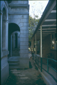
Slide - Hospital wing and Villa Alba portico, 1987–2001
Built for William and Anna-Maria Greenlaw in the early 1880s, and with interiors decorated by the Paterson Bros, Villa Alba remained in private ownership until 1949. From 1950, the house was owned by a number of institutions. By 1984, the Villa Alba Preservation Society had been formed, and three years later, the Mount Royal Hospital granted a 25-year lease to Kew Council. In 2004, the title to Villa Alba was passed by the Victorian Government to The Villa Alba Museum Incorporated. Digital copy of a oolour 35mm slide, framed in a plastic mount, of the entrance to Villa Alba, 44 Walmer Street, Kew, 3101. The transparency shows the grey rendered portico, viewed from the west, looking east. At this stage a wing of the hospital abutted the portico. The hospital wing was subsequently demolished and a Victorian era garden reinstated based on an original plan."Villa Alba ext"villa alba museum, historic houses -- kew (vic.), victorian architecture -- melbourne (vic.), mount royal hospital -
 Friends of Ballarat Botanical Gardens History Group
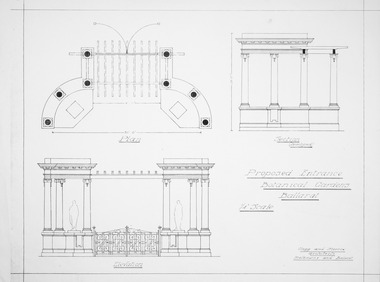
Plan - Proposed Entrance to Gardens; Clegg and Morris Architects, Melbourne and Ballarat
Shows proposed elevations and sections of proposed structureHistoricPhotocopy ballarat botanical gardens, buildings, plan, entrance -
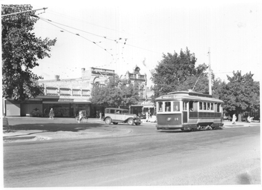
 Ballarat Tramway Museum
Photograph - Ballarat tram 14, City, early 1960s
Photograph shows Ballarat No. 14 in Sturt St crossing Lydiard St on its way to the Gardens. Tram has the dash canopy lighting but not the extended white strip on the front of the tram, indicating the photos is between 1961 and 1965. In the background is the Commonwealth Bank and the small newspaper kiosk advertising The Sun, the Herald, Craven A and Turf cigarettes. Photographer unknown. Two copies held.Yields information about tram 14 and the instersection of Sturt and Lydiard Sts.Black and white print - plain back.tramcars, city, sturt st, tram 14, commonwealth bank -
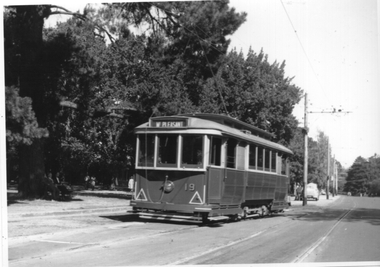 Ballarat Tramway Museum
Photograph - Ballarat tram 19 Gardens Loop, mid to late 1950s
The photograph shows Ballarat tram No. 19 (Mt Pleasant) at Gardens Loop North in Wendouree Parade. Photo mid 1950s. Photographer unknown. Yields information about tram 19 at Gardens loop in the mid to late 1950s.Black and white print - plain back. Two copies held.tramcars, tramways, wendouee parade, tram 19, gardens loop -
 University of Melbourne, Burnley Campus Archives
Certificate, The Royal Horticultural Society of Victoria, 1933-1934
(1) Spring Show 1933, Exhibit: Display of Spring Flowers, Highly Commended, Awarded to Burnley Horticultural Past Students Association. (2) Chrysanthemum Show 1934, Exhibit: Display ? Flowers and ? ?, Class: Non Competitive, Commended, Awarded to Burnley Horticultural Past Students Association. (3) Victorian Centenary Horticultural Council, the Burnley Horticultural Past Students Association Exhibited Alpine Garden and Wall Ornamentation at the Combined Centenary Horticultural Exhibition, Fitzroy Gardens, Melbourne 23rd to 27th October, 1934. (4) Malvern and District Horticultural Society, Commended, Awarded to Burnley Past Students , Display Autumn Show 1934.spring show, flowers, chrysanthemum, autumn show, display -
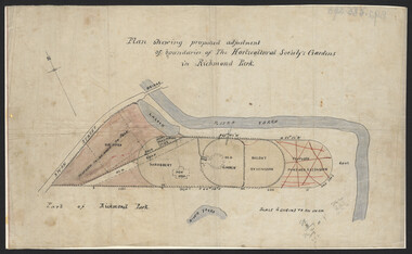 University of Melbourne, Burnley Campus Archives
Plan, John S. Jenkins, Plan showing proposed adjustment of boundaries of the Horticultural Society's Gardens in Richmond Park, c.1880-1884
Plan on linen fibre cloth. Shows layout of Burnley bound by Swan St., Yarra River and part of Richmond Park, coloured areas showing proposed area to be added to Park, the old road, shrubbery, new hall, old garden, recent extension and proposed further extension (crossed out in red ink). Scale 4 chains:1 inch. Probably drawn by John S. Jenkins, Town Surveyor, Richmond. Has been photographed so that additional copies can be made. On a CD plus 3 negatives, plus small coloured print. (Also copy glazed and framed for Centenary Exhibition - B92.0540.)john s. jenkins, gardens, richmond, hoticultural society of victoria -
 Royal Australasian College of Surgeons Museum and Archives
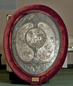
Plaque - Shield, Elkington & Co, Milton Shield, 1867
The Milton Shield was given to the College in 1968 by the eminent Sydney surgeon Conrad Blakemore (1898-1976), whose family had owned it for almost 100 years. There are three known examples of this Shield in Australia. They are electrotype reproductions made by Elkington & Co. of an original created by Léonard Morel-Ladeuil between 1864 and 1866, and exhibited in Paris at the Exposition Universelle of 1867. The original is made of silver and damascened iron, measures 880mm by 630mm, and is now in the Victoria & Albert Museum in London.There are three known examples of this Shield in Australia. They are electrotype reproductions made by Elkington & Co. of an original created by Léonard Morel-Ladeuil between 1864 and 1866, and exhibited in Paris at the Exposition Universelle of 1867. The original is made of silver and damascened iron, measures 880mm by 630mm, and is now in the Victoria & Albert Museum in London.The Shield is oval in shape, and is divided into several fields, each of which shows a different scene. The entire surface is covered in floral and animal decoration, and patterns. A cable moulding runs around the outer edge. The College’s Shield is set in a heavy timber frame bordered with red velvet and glazed.The central area is circular, depicting the archangel Raphael telling the story of the war in Heaven to Adam and Eve in the Garden of Eden. Immediately below this is the figure of the archangel Michael trampling on the defeated Satan. At the bottom of the shield are two figures representing Sin and Death. On either side of the central circle is a kidney-shaped field, the one on the left showing the army of the rebel angels assaulting Heaven, and on the right the fall of the rebel angels. At the top of the Shield are figures of cherubim and seraphim. The name of the Shield derives from the scenes on it, illustrating episodes from Paradise Lost by John Milton (1608-1674). Presented by Conrad Blackmoremilton shield, conrad blakemore, 1968, léonard morel-ladeuil -
 Lakes Entrance Historical Society
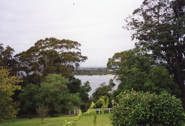
Photograph - Fraser Island, Holding M, 2000c
Colour photograph taken from the veranda of Nyerimilang Homestead, Gippsland Lakes. It shows a glimpse of Fraser Island through the trees and ornamental shrubs of the homestead garden. Fence and pathway to viewing platform in centre foreground. Lakes Entrance Victoriaislands, historic site -
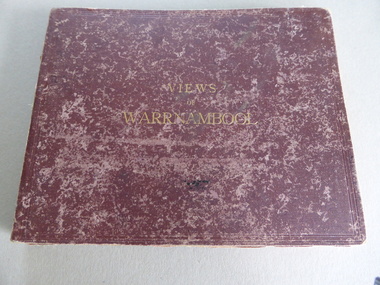 Warrnambool and District Historical Society Inc.
Album, Photographs Views of Warrnambool, c 1891
This album contains photographs of many Warrnambool buildings and scenes, including Proudfoot Boatsheds, St. John’s Church, Christ Church, Shelly Beach, Hopkins Falls, Sherwood gardens and buildings, Ozone Coffee Palace, Kepler Street, Sandstone Quarries and the Titan Crane on the Breakwater. The photographs have been taken and put in album form by the photographer Joseph Jordan. The advertisements of the hotels on the inside covers place the publication of the album to the years1891-2. We have another album similar to this but there are six photographs in this album (VC000799) that are not in the other album. These extra photographs are of the original gardens and buildings of Sherwood.This is a most important album as the photographs are clear and show a good cross-section of Warrnambool in the early 1890s. Some of the photographs are not represented in other collections (eg Sherwood gardens) and so are of vital historical significance. The advertisements are also of great use to researchers.This album has a brown hard cover and contains three pages of local advertisements and sixteen pages of photographs and 32 photographs back to back. The pages have been bound but some pages have come loose. There is a fold-out section of a 180 degree panorama of Warrnambool taken from Liebig Street hill. The edges of these pages have been taped.Front Cover- Views of Warrnamboolwarrnambool, views of warrnambool, photos of warrnambool -
 Ballarat Tramway Museum
Photograph - Ballarat trams 16 and 34 Wendouree Parade, Ken Winney, 12/1949
The photograph shows SEC Ballarat trams 16 (Mt Pleasant) and 34 (Gardens via Sturt St West) crossing at the Carlton St loop. The conductor is standing in the rear door of No. 16. The grass alongside Wendouree Parade is overgrown. Photo by I K Winney of Sydney, 12/1949.Yields information about the use of Carlton St loop during 1934Black and white photograph with photographers details on rear."Car No. 16 and 34 on loop on west side of lake, Ballarat. 12/1949, I K Winney"tramcars, sturt st, wendouree parade, tram 16, tram 34, carlton st loop -
 Ballarat Tramway Museum
Photograph - Ballarat tram 14 - Sturt St, Ken Winney, 12/1949
The photograph shows SEC Ballarat tram No. 14 at the intersection of Sturt and Dawson Sts outbound to the Gardens via Sturt St West. The tram is in the green and cream rocker panels livery. The overhead for the Dawson St crossover is visible. Photo by I K Winney of Sydney, 12/1949.Yields information about tram 14 and the corner of Sturt and Dawson Sts during 1949.Black and white photograph with photographers details on rear."Car No. 14 cnr Sturt & Dawson Sts en route to Gardens via Sturt St W". 12/1949, I K Winneytramcars, sturt st, dawson st, tram 14 -
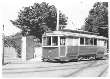 Ballarat Tramway Museum
Photograph - Ballarat tram 11 running in to the Depot, Ken Winney, 12/1949
The photograph shows SEC Ballarat tram No. 11 running into the SECV Wendouree Parade Depot. Tram has the destination of Gardens via Sturt St West indicating it ran in from the Gardens and revesed outside the depot. Photo by I K Winney of Sydney, 12/1949.Yields information about tram 11 and the depot run in tracks in 1949.Black and white photograph with photographers details on rear."Car No. 11 outside Ballarat Depot, near Gardens terminus 12/1949, I K Winney"tramcars, sec depot, tram 11, wendouree parade -
 Kiewa Valley Historical Society
Photos - Mills Family x 15
Brian and Jill Mills lived with their children at Lakeside Ave. Mt Beauty. Brian was in the airforce.4 photos were taken during the construction of the Kiewa Hydro Electric Scheme. 1. The "Mills Kids" beside the river - show the fashion of the time and how families spent their recreational time. 2.& 3. The "70 Lakeside Ave" photos show the type of housing provided by the SECV and that the garden hadn't been created. 4. SEC marshalling yards, Mt Beauty c 1940s-50s. An historic photo of 1940s/50s buses used to transport KHES workers to their work sites, some of which were on the High Plains.15 large photos scanned in colour. 5 have labels written on the backOn the back "Brian Mills" (in airforce uniform); "Mills Kids / 78 L/side Ave"; "70 Lakeside Ave"; "70 L/side Ave" and "SEC Marshalling yards - Mt Beauty (and Donor's name and address.lakeside ave mt beauty, brian mills -
 Bendigo Historical Society Inc.
Photograph - SPECIMEN COTTAGE HARGREAVES STREET, BENDIGO
3 photos: Colour photo of Specimen Cottage, taken from footpath looking northwards. Image shows student on LH side walking on footpath, trees in leaf either side of building. Cottage is built from sandstone, wooden balcony. Colour photo of the conservatory and gardens taken from an elevated position. Colour photo Golden Dragon Museum. All Photos taken in April 2001. Piece of paper in the pocket identifies Gordon & Wendy Willa, of deakin St Lockington 3563, and email: gordon&[email protected], buildings, specimen cottage, sandhurst, bendigo, specimen cottage, hargreaves street, building, brierley -
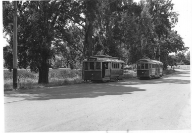
 Ballarat Tramway Museum
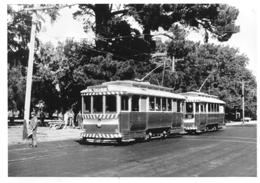
Photograph - Tram 34 Wendouree Parade - Gardens, mid to late 1950s
The photograph shows SEC Ballarat tram No. 34 in Wendouree Parade, having just left Gardens loop on its way to Mt Pleasant. Not known who took the photo or the date. Post 1956 to 1960 given the large reflective triangles on the end panel.Yields information about tram 34 appearance in the mid to late 1960s.Black and white print on plain paper.tramcars, tram 34, wendouree parade, gardens -
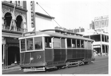 Ballarat Tramway Museum
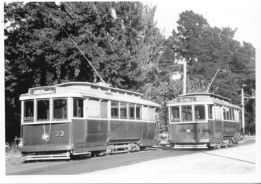
Photograph - Tram 33 lower Sturt St, mid 1950s
The photograph shows SEC Ballarat tram No. 33 (Gardens via Drummond St North) in lower Sturt St mid 1950s with tail lights installed. In the background is the Ballaarat Gas Co. building, Patersons, a hotel and the Ballarat Mechanics Institute Building with signs for Robur Tea and Davies Bread. Photographer unknown.Yields information about tram 33 and lower Sturt St mid 1950s.Black and white print with plain back.tramcars, tram 33, sturt st -
 Ballarat Tramway Museum
Photograph - Trams 33 and 12 crossing Wendouree Parade, mid 1950s
The photograph shows SEC Ballarat tram No. 33 (Gardens via Drummond St North) and No. 12 (Mt Pleasant) crossing each other in Wendouree Parade, mid 1950s with tail lights installed. Photographer unknown.Yields information about tram 33 tram 12 during the mid 1950s in Wendoure Parade.Black and white print with plain back.tramcars, tram 33, wendouree parade, tram 12 -
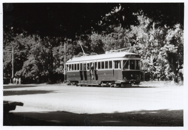
 Ballarat Tramway Museum
Photograph - BTPS trams at Gardens Loop, late 1970s
The photograph shows BTPS-operated tram No. 14 and possibly No. 27 at Gardens Loop heading north to St Aidans Drive. The second tram is carrying a "Tram Rides" sign. Photo the mid to late 1970s given the large trees behind which were later removed. Photographer unknown. Yields information about BTPS operations in the late 1970s and Gardens Loop.Black and white print - plain back. Two copies held.tramcars, tramways, btps, tram 14, gardens loop, wendouree parade -
 Glenelg Shire Council Cultural Collection
Painting, Helen Fergusson, Pat's Joy, 1998
... 1998 Portland Rotary Art Show landscape garden flowers ...1998 Portland Rotary Art ShowScene of a cottage in a wild garden. There is a mountain in the background of the right. Blue sky with light clouds. Mounted in cream and dark gray double matt, framed under glass in gold-coloured wooden frame.Front: Helen Ferguson Back: (no inscriptions)landscape, garden, flowers, rotary, mountain -
Port Melbourne Historical & Preservation Society
Photograph - Aerial view, The Boulevard Upgrade Sandridge Beach, Oct 2003
Shows an aerial photographic view of Garden City with five smaller pictures of different locations relevant to the upgrade of the boulevard.Existing conditions the Boulevard Upgrade Sandridge Beach 1:500 October 2003 City of Port Phillip.local government - city of port phillip, fred jackson reserve, advertising, perce white reserve, frederick charles jackson, perce mcguire white, perce white -
 Melbourne Tram Museum
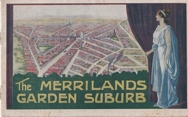
Book, T. M. Burke, "The Merrilands Garden Suburb", late 1919
Book - 12 pages with a fold out double page centre map, centre stapled, titled "The Merrilands Garden Suburb", a real estate marketing brochure for area to the west of the Reservoir rail line, known locally as Merrilands. Marketed on being a gardens suburb to the then Town Planning situation. Contains a suggested loop tram system. Has sales conditions, general information. Marketed by T. M. Burke of 340 Collin St Melbourne. Fold out surveyors map, by Saxil Tuxen, Licensed Surveyor date Oct. 1919. Shows suggested tram routes, reserves, and civic centre.trams, tramways, real estate, reservoir, proposals, new tramway, land -
 Melbourne Tram Museum
Photograph - Candy Corner - St Kilda - opposite Luna Park - Esplanade, Early 1940s
Photograph shows the cafe and adjacent buildings on the area that was enclosed by Esplanade tram Loop or Luna Park loop. Known as "Candy Corner" on MMTB drawings and locally. The reference page 9 gives the background to the site and its use. The café was designed by Carlo Catani, who is also remembered as the landscape designer for other parts of St Kilda including Catani Gardens. It is now used by a McDonalds store. In front of the building is a board advertising or promoting World War 2 war-saving schemes for St Kilda streets. This dates the photos to early 1940s.Yields information about Candy Corner buildings Black and white photograph on paper.trams, tramways, luna park loop, candy corner, st kilda, esplanade, loops, carlo catani, world war 2, street savings scheme -
 Melbourne Tram Museum
Map, Melbourne & Metropolitan Tramways Board (MMTB), Set of 8 bus route maps, 1977 to 1979
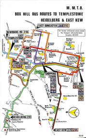
Series of colour route maps for various bus or groups of tram lines for the MMTB. Some have the Transport Information Centre telephone printed on them, others have a label stuck on. Some are finished with a plastic laminate finish on either one or both sides. Show the major cross streets, parks, schools, other tram routes, major stop numbers and railway lines. .1 - Box Hill bus routes to Templestowe - R38/82, Heidelberg and East Kew, includes Doncaster, Shoppingtown and Newmans Road. .2 - Clifton Hill - R2/79 - Elsternwick, Point Ormond and St Kilda Junction .3 - Footscray, Sunshine, Deer Park, Nth Altona, Fishermen's Bend, Highpoint and Williamstown Road - R2/79. .4 - Bulleen - City - Port Melbourne - Garden City Bus Route, including Kew, Collingwood - R6/78 .5 - City - Warrandyte and East Doncaster including Newmans Road, Templestowe, East Doncaster, Donvale, Shopping town, and Kew. R3/82. .6 - West Heidelberg, La Trobe University, Northland - R3/81 .7 - Box Hill, Ringwood to East Doncaster and Warrandyte, Park Orchards, North Blackburn R3/82. .8 - Geelong - Herne Hill, Rollins Road, Donnybrook Rd, North Shore and Corio Villagetrams, tramways, maps, route guide, route numbers, routes, buses, box hill, templestowe, doncaster, east kew, heidelberg, clifton hill, point ormond, elsternwick, footscray, sunshine, deer park, north altona, fishermen's bend, highpoint, williamstown rd, bulleen, kew, collingwood, port melbourne, garden city, warrandyte, donvale, la trobe university, northland, ringwood, park orchards, mitcham, blackburn, geelong -
 Melbourne Tram Museum
Photograph - Set of 2 Black & White Photograph/s, Melbourne & Metropolitan Tramways Board (MMTB), Cable set No. 1, c1940
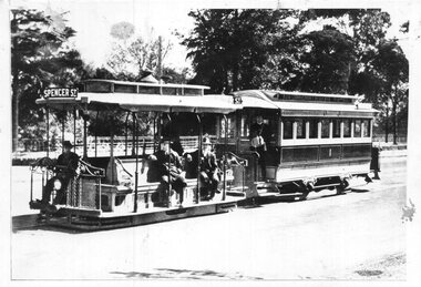
Photograph show the MMTB / MTO Co cable tram set No. 1 inbound in Nicholson St Fitzroy with the Carlton Gardens in the background - Destination of Spencer St. Has a small number of passengers and the conductor standing on the trailer. Two copies held. The livery is non-standard for the time. Official MMTB Photograph - used in a Annual Report. .1 - Photo taken in the same location but looking from the rear of the cable tram set. Has the Exhibition buildings in the background. Two copies held. See Reg Item 897 for a newspaper clipping of the 2nd photo.Yields information about cable tram set No. 1, which was presented to the Science Museum when the cable tram system closed.Photographs, Black and White, set of two.In ink on the rear: KSK print numbers SA909 On rear of .1 "MMTB" and "H202"trams, tramways, mmtb, cable trams, mto co, nicholson st, tram 1 -
 Melbourne Tram Museum
Poster, Public Transport Corporation (PTC), "Public Transport Corporation - Your travel made easy", late 1990s
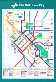
Set of six large posters, featuring the tram map of Melbourne, Inner City, Northern and Southern sections. Items .1 to .3 have an adhesive backing for application onto a tramcar advertising rack. Items .4 to .6 are photocopies of the same with corrections or suggested changes, all c1990. .1 - Inner City - approx. A3, Has the revised The Met symbol with a key along the lower edge detailing route numbers and routes. .2 - Southern Region Tram Map with a map key showing hospitals, points of interest, parks and gardens, some schools and zones. Also shows trams routes through the city, rail lines, stations and major roads with bus routes. .3 - ditto for the Northern Region .4 - Photocopy of the Inner City area with corrections which have been picked up on the final version. .5 - ditto for the Southern Region, two sheets joined together with tape. .6 - ditto for the Northern Region. Items .4 to .6 not scanned.trams, tramways, ptc, posters, trams, the met, map, tram routes, bus routes, route numbers -
 Melbourne Tram Museum
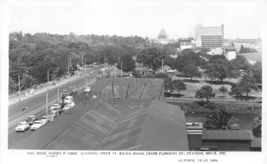
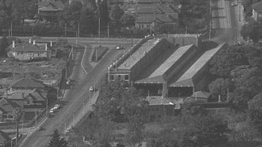
Postcard, Rose Stereograph Co, Flinders St station clock tower looking south towards the Shrine, 1956
Postcard - Rose Series black and white of the view from the Flinders St station clock tower looking south towards the Shrine. Shows St Kilda Road, Prince Henry's Hospital, the Yarra River and the gardens on the south side of the river. Has two trams in the view. On the lower edge of the card "The Rose Series P13602 Looking over St Kilda Road from Flinders St Station Melb. Vic" and "Olympic Year 1956". On the rear is a note written to Keith from Ken of Barkly St Mornington on 14/1/58 mainly about a Pat Lyton? now a tram conductor at Hanna St and a meeting with Brian. Has some personal notes about Pat.trams, tramways, flinders st, postcards, st kilda road -
 Melbourne Tram Museum
Photograph - Digital Image, Burnley Gardens, and Hawthorn district with a close up of the Hawthorn Tram depot, c1960
Digital image of the Burnley Gardens, and Hawthorn district with a close-up of the Hawthorn Tram depot and the intersection of Wallen Road, Power Sts and Riversdale Roads - c1950, prior to the construction of St Anthony's church. Shows the traffic arrangements at the intersection, tram depot buildings and the intersection prior to the reconstruction of the entry into Riversdale Road. Original photo from the Hawthorn Historical Society website - Sourced by Ron Scholten 24/1/2021trams, tramways, hawthorn depot, wallen road, riversdale road, burnley -
 Melbourne Tram Museum
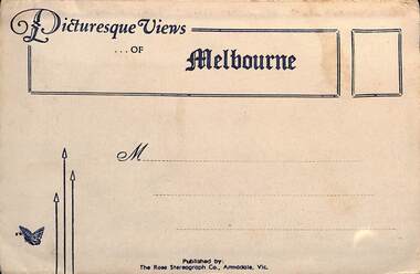
Postcard - Folder, Rose Stereograph Co, "Picturesque Views of Melbourne", mid 1930s
Comprises 12 photos of Melbourne, mid to late 1930s. Produced by Rose Stereograph of Armadale. 1 - Botanical Gardens and Government House Melbourne. - 2 - The MacRobertson Fountain Melbourne - Both the Fountain and the Shrine of Remembrance were completed in 1934. Government House tower features in the background. Also note the absence of any mature trees. See reference - completed 1934. 3 - Flinders Street Railway Station with a "W" class tram in Flinders Street and "Y" class tram in Swanston Street in the view 4 - St Kilda Road Melbourne - Looking south with the Queen Victoria Gardens in the left of the photo. 5 - Collins Street Melbourne - Showing the Regent Theatre, Manchester Unity Building and the Town Hall. 6 - Princes Bridge and city Skyline Melbourne - Shows; Princes Bridge, Yarra River, Excursion Ferry, Princes Walk, Flinders Street Railway Station, the Nicholas and Manchester Unity Buildings in Swanston Street and the Sargood Gardner building in Flinders Street. 7 - The Conservatory, Fitzroy Gardens Melbourne - 8 - The Cathedral Corner Melbourne - shows; Young & Jacksons Hotel, St Paul's Cathedral, The Gas & Fuel building, Ball & Walsh Department store and The State Theatre plus several "w" class trams in Swanston Street. 9 - St Kilda Road Melbourne - Looking south from Nolan Street. Note trees still present at the entrance area to the Shrine of Remembrance. 10 - Looking across Princes Bridge to St Kilda Road Melbourne - Looking south from the roof of the Nicolas Building showing; Princes Bridge, St. Kilda Road, The Shrine of Remembrance and the Victoria Barracks in the distance. 11 - Parliament House Melbourne - in Spring Street 12 - Captain Cook's Cottage, Fitzroy Gardens Melbourne - Erected in the gardens in 1934. Yields information about Melbourne city views and new attractions mid 1930s. Paper envelope folder with 6 photos on each side of a foldout section titled "Picturesque Views of Melbourne" melbourne, photo folders, postcards