Showing 1495 items
matching maroondah
-
 Marysville & District Historical Society
Photograph (Item) - Black and white photograph, Fernshaw, c1900
An early black and white photograph taken at Fernshaw.An early black and white photograph taken at Fernshaw. Fernshaw was a rural township 63 km north-east of Melbourne and 10 km north-east of Healesville. Situated on the Watts River, near where a log had fallen making a convenient crossing, Fernshaw was settled in the 1860s. It provided good country for orchards and berry growing. The location was at the foot of Blacks Spur, with Mounts Juliet and Mondah rising on either side, providing spectacular scenery. There were nearby fern gullies giving rise to the name – ‘shaw’ is old English for thicket or wood. By 1875 Fernshaw had a post office (1865), two hotels, a school (1871) and stores. It was famed for its beauty, attracting tourists. In 1886 the Melbourne and Metropolitan Board of Works began work on the Watts River water catchment scheme – later to become Maroondah – and the Board obtained approval for the catchment country to be reserved and kept free of settlement. This required the removal of the Fernshaw township, which was completed by about 1890. The area was described in the 1903 Australian handbook:ARMSTRONG COLLECTION 42 STATION STREET/ SANDRINGHAM 3191/ TEL. (03) 9521 5442/ IAN M.L. ARMSTRONG OAMfernshaw, healesville, watts river, orchard, berry orchard, blacks spur, black spur, mount juliet, mount mondah, maroondah dam, victoria -
 Marysville & District Historical Society
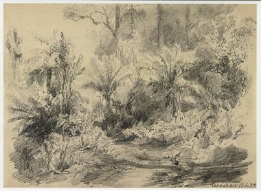
Artwork, other (Item) - Pencil Sketch, Louis Buvelot, Fernshaw 17.2.83, 1883
A copy of an early pencil sketch of Fernshaw in Victoria.A copy of an early pencil sketch of Fernshaw in Victoria by Louis Buvelot. Louis Buvelot ( 1814–1888), born Abram-Louis Buvelot, was a Swiss landscape painter who lived 17 years in Brazil and following 5 years back in Switzerland stayed 23 years in Australia, where he influenced the Heidelberg School of painters. Arriving in Melbourne in February 1865, after leaving the cold of Switzerland, which was impacting on his health, for the warmth of Australia, Buvelot was in business as a photographer in Bourke Street for a year but soon resumed his painting. He lived in Melbourne for a number of years before moving to Fitzroy. The National Gallery of Victoria purchased two of his paintings and he continued painting until his death in 1888. He was buried at the Boroondara Cemetery, where a large monument was erected in his memory. Fernshaw was a rural township 63 km northeast of Melbourne and 10 km northeast of Healesville. Situated on the Watts River, near where a log had fallen making a convenient crossing, Fernshaw was settled in the 1860s. It provided good country for orchards and berry growing. The location was at the foot of Blacks Spur, with Mounts Juliet and Mondah rising on either side, providing spectacular scenery. There were nearby fern gullies giving rise to the name – ‘shaw’ is old English for thicket or wood. By 1875 Fernshaw had a post office (1865), two hotels, a school (1871), and stores. It was famed for its beauty, attracting tourists. In 1886 the Melbourne and Metropolitan Board of Works began work on the Watts River water catchment scheme – later to become Maroondah – and the Board obtained approval for the catchment country to be reserved and kept free of settlement. This required the removal of the Fernshaw township, which was completed by about 1890.Fernshaw 17.2.83louis buvelot, fernshaw, victoria, national gallery of victoria, switzerland, boroondara cemetery, kew cemetery, artist -
 Marysville & District Historical Society
Painting (Item) - Oil painting, Isaac Whitehead, A spring morning near Fernshaw 1880, 1880
A copy of an early oil painting of Fernshaw in Victoria.A copy of an early oil painting of Fernshaw in Victoria by Isaac Whitehead. Isaac Whitehead (1819–1881) was an Irish-Australian artist who worked in watercolour and pastel. He was also a picture framer and art promoter. It is believed that Isaaz Whitehead emigrated to Australia with his family in either 1853 or 1858. Isaac Whitehead died at his home 50 Punt Road, Prahran, Melbourne, on 21 April 1881. Isaac Whitehead had established himself as the foremost picture framer in Melbourne by 1860, known for his highly ornate frames with floral decorations. Among the clients of his framing business were Louis Buvelot, Nicholas Chevalier, and Eugene von Guérard. In his own paintings, he painted a number of scenes of the forests of Gippsland, Victoria. His work focused on the rich landscapes with trees and ferns, with a high degree of botanical detail. His work won him two medals and his work was posthumously exhibited at 1884 Victorian Jubilee Exhibition, the 1886 London Colonial and Indian Exhibition, and the 1888 Melbourne Centennial Intercolonial Exhibition. Fernshaw was a rural township 63 km northeast of Melbourne and 10 km northeast of Healesville. Situated on the Watts River, near where a log had fallen making a convenient crossing, Fernshaw was settled in the 1860s. It provided good country for orchards and berry growing. The location was at the foot of Blacks Spur, with Mounts Juliet and Mondah rising on either side, providing spectacular scenery. There were nearby fern gullies giving rise to the name – ‘shaw’ is old English for thicket or wood. By 1875 Fernshaw had a post office (1865), two hotels, a school (1871), and stores. It was famed for its beauty, attracting tourists. In 1886 the Melbourne and Metropolitan Board of Works began work on the Watts River water catchment scheme – later to become Maroondah – and the Board obtained approval for the catchment country to be reserved and kept free of settlement. This required the removal of the Fernshaw township, which was completed by about 1890.isaac whitehead, fernshaw, victoria, louis buvelot, nicholas chevalier, eugene von guerard, gippsland, victorian jubilee exhibition, london colonial and indian exhibition, melbourne centennial intercolonial exhibition, watts river, healesville, blacks spur, mount juliet, mount mondah -
 Marysville & District Historical Society
Photograph (Item) - Black and white photograph, Fred Kruger, Scene on the Watts River near Fernshaw, Unknown
A copy of a black and white photograph on the Watts River near Fernshaw in Victoria.A copy of a black and white photograph on the Watts River near Fernshaw in Victoria taken by Fred Kruger. Fred Kruger (born Johan Friedrich Carl Kruger, 18 April 1831 – 15 February 1888) was a German-born photographer noted for his early photography of landscape and indigenous peoples in Victoria, Australia. Fernshaw was a rural township 63 km northeast of Melbourne and 10 km northeast of Healesville. Situated on the Watts River, near where a log had fallen making a convenient crossing, Fernshaw was settled in the 1860s. It provided good country for orchards and berry growing. The location was at the foot of Blacks Spur, with Mounts Juliet and Mondah rising on either side, providing spectacular scenery. There were nearby fern gullies giving rise to the name – ‘shaw’ is old English for thicket or wood. By 1875 Fernshaw had a post office (1865), two hotels, a school (1871), and stores. It was famed for its beauty, attracting tourists. In 1886 the Melbourne and Metropolitan Board of Works began work on the Watts River water catchment scheme – later to become Maroondah – and the Board obtained approval for the catchment country to be reserved and kept free of settlement. This required the removal of the Fernshaw township, which was completed by about 1890.fernshaw, watts river, victoria, fred kruger, photograph -
 Box Hill Historical Society
Book, Marc Fiddian, Wandering Whitehorse Road, 2014
From Kew to Mansfield along Cotham Road, Whitehorse Road or Maroondah Highway108 pagesnon-fictionFrom Kew to Mansfield along Cotham Road, Whitehorse Road or Maroondah Highwaywhitehorse road, maroondah highway, fiddian> mark -
Whitehorse Historical Society Inc.
Document, Eastern Freeway Extension, 2000 - 2001
Agendas, minutes and papers of the Eastern Freeway Extension Community Liaison GroupAgendas, minutes and papers of the Eastern Freeway Extension Community Liaison Group (Nos 18 - 25) and Community Advisory Group (No 1 - ) Springvale Road to Ringwood with Community Workshops. Consolidated notes on the Extension and Funnel Ventilation Stacks.Agendas, minutes and papers of the Eastern Freeway Extension Community Liaison Groupeastern freeway, vicroads, city of whitehorse, city of manningham, city of maroondah -
Whitehorse Historical Society Inc.
Map, Whitehorse Road, Mitcham, 1972
Enlarged aerial photograph of area around intersection of Whitehorse Road and Heatherdale Roads, Mitcham.Enlarged aerial photograph of area around intersection of Whitehorse Road and Heatherdale Roads, Mitcham.Enlarged aerial photograph of area around intersection of Whitehorse Road and Heatherdale Roads, Mitcham.whitehorse road, mitcham, heatherdale road, mitcham, ringwood, maroondah highway, aerial photographs -
Whitehorse Historical Society Inc.
Map, Whitehorse Road, Blackburn, 1970
Enlarged aerial photograph of area around intersection of Whitehorse and Middleborough Roads, BlackburnEnlarged aerial photograph of area around intersection of Whitehorse and Middleborough Roads, BlackburnEnlarged aerial photograph of area around intersection of Whitehorse and Middleborough Roads, Blackburnwhitehorse road, blackburn, middleborough road, blackburn, maroondah highway, box hill, aerial photographs -
Whitehorse Historical Society Inc.
Map, Walker Park, Nunawading, c1970?
Enlarged aerial photograph of area of Walker Park, Nunawading, 1970 runEnlarged aerial photograph of area of Walker Park, Nunawading, 1970 run.Enlarged aerial photograph of area of Walker Park, Nunawading, 1970 runwalker park, whitehorse road, nunawading, maroondah highway, dunlavin road, nunawading, mitcham technical school, aerial photographs -
Whitehorse Historical Society Inc.
Map, Mitcham Road, c1970
Enlarged aerial photograph of intersection of Whitehorse and Mitcham Roads, Mitcham. Scale 1 inch : 40 feetEnlarged aerial photograph of intersection of Whitehorse and Mitcham Roads, Mitcham. Scale 1 inch : 40 feetEnlarged aerial photograph of intersection of Whitehorse and Mitcham Roads, Mitcham. Scale 1 inch : 40 feetmitcham road, mitcham, maroondah highway, mitcham, whitehorse road, mitcham, mitcham primary school, no. 2904, mitcham hotel, aerial photographs -
Whitehorse Historical Society Inc.
Map, Blackburn, 13/01/1977 12:00:00 AM
Enlarged aerial photograph of Blackburn Business Centre. Scale 1:150 metric.Enlarged aerial photograph of Blackburn Business Centre. Scale 1:150 metric.Enlarged aerial photograph of Blackburn Business Centre. Scale 1:150 metric.blackburn, blackburn road, blackburn, south parade, blackburn, railway road, blackburn, maroondah highway, blackburn, whitehorse road, blackburn, chapel street, blackburn, albert street, blackburn, queen street, blackburn, station street, blackburn, blackburn railway station, blackburn primary school, no. 2923, aerial photographs -
Whitehorse Historical Society Inc.
Map, Springvale Road, c1970
Enlarged aerial photo of intersection of Springvale and Whitehorse Roads, Nunawading.Enlarged aerial photo of intersection of Springvale and Whitehorse Roads, Nunawading.Enlarged aerial photo of intersection of Springvale and Whitehorse Roads, Nunawading.springvale road, nunawading, whitehorse road, nunawading, maroondah highway, nunawading, aerial photographs -
Whitehorse Historical Society Inc.
Map, Proposed shared path network, 2001
Draft plans of proposed shared path networkDraft plans of proposed shared path network for Eastern Freeway Extension, Springvale Road to Ringwood.Draft plans of proposed shared path network plans, eastern freeway extension, city of whitehorse, vicroads, city of maroondah, vicroads bicycle coordinator, footpaths, bicycle paths -
Whitehorse Historical Society Inc.
Article, Mitcham building sold for over $1 million, 1997
A commercial property in Mitcham Strip Shopping Centre has been sold for more than $1 million.A commercial property in Mitcham Strip Shopping Centre has been sold for more than $1 million. The property was owned by former pharmacists George Greenberg and Petere Scurrah.A commercial property in Mitcham Strip Shopping Centre has been sold for more than $1 million.shops, greenberg, george, scurrah, peter, maroondah apothecary, mitcham shopping centre -
Whitehorse Historical Society Inc.
Article, Nissan dealership closes its door, 1991
Article describing the closure of car dealerships in 1991Article describing the closure of car dealerships in 1991Article describing the closure of car dealerships in 1991brian roberts nissan, cars, ken morgan toyota, east city holden, maroondah highway, nunawading, rooks road, whitehorse road, blackburn, chapel street -
Whitehorse Historical Society Inc.
Programme - Ephemera, Theatre and concert programs, 1967 - 1986
Selection of programs dating from 1967 to 1986, musical concerts and plays by groups from Blackburn, Nunawading, Box Hill and Mitcham. Includes list of Mitcham Repertory Group's plays from 1953 - 1985.drama, nunawading arts council, the avenue uniting church, blackburn, bellburn singers, maroondah singers, acacia singers, nova theatre, box hill city repertory, eastern theatre group, mitcham repertory group, blackburn players -
Whitehorse Historical Society Inc.
Article, Doyen of Arts Scene Steps Into The Wings, 1988
Retirement of Max Grant, foundation member of the Nunawading Arts Council and pioneer of amateur theatre in Nunawading. With photo.drama, nunawading arts council, mitcham repertory group, mitcham memorial hall, grant, max, nunawading arts centre, the avenue church players, maroondah musical society, blackburn players -
Whitehorse Historical Society Inc.
Document - Documents, Group reports, 2000
Annual reports presented to the Nunawading Arts Council Annual meeting by affiliated bodies. Includes an obituary for Ossie Maxwell Max Grant, theatre director who lived in Mitcham from the early 1950s until his death 22 Sept 2000.nunawading arts council, grant, max, nunawading art and craft market, australian childrens choir, babirra music theatre, box hill art group, blackburn high school. friends of music, choral institute melbourne, chime choir, eastern victorian highland dancing association, maroondah symphony orchestra, mitcham arts association, maroondah singers, mullauna secondary college music department, mitcham repertory group, nunawading and district historical society, nova theatre, u3a nunawading, vermont horticultural society and garden club, utassy parents association, vermont secondary college. music support group, whitehorse film society -
Whitehorse Historical Society Inc.
Magazine - Periodical, Mitcham Towers
Mitcham Towers decision highlights the need for reform of VCAT and the Planning Act.Mitcham Towers decision highlights the need for reform of VCAT and the Planning Act.Mitcham Towers decision highlights the need for reform of VCAT and the Planning Act.maroondah highway, mitcham, victorian civil and administrative tribunal, mitcham towers -
 Whitehorse Historical Society Inc.
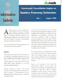
Pamphlet, Eastern Freeway Extension, 1/08/1998 12:00:00 AM
Information bulletin giving history map showing features of extension,Information bulletin giving history map showing features of extension, members of liaison group established for consultation.Information bulletin giving history map showing features of extension,freeways, springvale road, nunawading, mitcham road, mitcham, park road, mullum mullum creek, deep creek road, loughnan road, ringwood, harrison street, acacia court, maroondah highway, city of whitehorse, city of manningham, city of maroondah, melbourne water, victoria. department of natural resources and environment, environment protection authority, victoria, vicroads, eastern freeway -
Whitehorse Historical Society Inc.
Article, Crash Capital of Australia, 2017
Springvale Road is the nation's worst for insurance claims for the fifth year in a row.Springvale Road is the nation's worst for insurance claims for the fifth year in a row.Springvale Road is the nation's worst for insurance claims for the fifth year in a row.whitehorse road, traffic, accidents, maroondah highway -
 Whitehorse Historical Society Inc.
Document, Arts and Culture, Whitehorse News, 2008
Overview of the history of arts and culture and sports and recreation in the city of Whitehorse5 pgs single sided, printoutOverview of the history of arts and culture and sports and recreation in the city of Whitehorse arts culture, sports recreation, atheletics, choir, mary pearce, mary matheson, beatrice pooley, amanda liebert, hazel mourney, corinne kirby, keith satchwell, mitcham choral society, maroondah singers, nunawading arts council, nunawading arts centre, forest hill tennis club, enid miller, dawn black, dot browne, mitcham tennis club, gwen holmes, hilites netball club, doncaster womens athletic club, charles matheson, walter j frankhauser, strathdon community, blackburn presbyterian church, mitcham presbyterian church, vermont presbyterian church, fred pooley, blue moon fruit cooperative, william slater, utassy ballet, m pearce -
 Whitehorse Historical Society Inc.
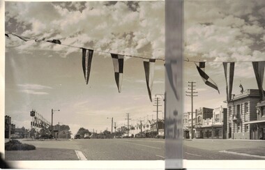
Photograph, Royal Visit 1954
Royal visit 1954 showing street decorations looking East.Whitehorse Road Looking East showing bunting in Mitchammaroondah highway mitcham, royal visit 1954, decorations -
 Kew Historical Society Inc
Album - Photograph Album No.1, Henry Beater Christian, 1924-26
Henry Christian (c.1809-91), the grandfather of the photographer, was one of the first settlers in Kew. He arrived in Victoria with his wife Agnes and son Orlando in 1855 on the Gypsy Queen. He established a rope-making business in Bulleen Road by 1858 but was declared insolvent two years later. In his final years, he was celebrated as one of the oldest living settlers of the district. His son, Orlando Henry Beater Christian (c.1853-1930) became a member of the Hawthorn Band and a foundation member of the Willsmere Swimming Club. Orlando and his wife Elizabeth had four children of which Henry Beater Christian (1886-1962) was the oldest.An album of photographs, compiled by Henry Beater Christian (1886-1962) of Pakington Street, Kew, depicting individuals, natural and settled environments and the interactions between these worlds. Henry Christian, was a keen explorer, not just of his immediate environment but also of the Victorian wilderness. His major opus is contained in two albums in which he records, sometimes in majestic detail and on other occasions the intimate features of the natural world. His photographic travels during the 1920s, often in solitary ramblings but on other occasions with companions, recall the heroic landscape photography of an earlier era, pioneered by Nicholas Caire. In addition to their aesthetic value, the albums are historically significant records within the State of Victoria, of what is now a distant point in time, and of places that have become radically altered through human intervention.Digital copy of a 47-page photograph album containing 255 gelatinous silver images, loaned by Diane Washfold with permission given to digitise and hold a copy in our collection. The album contains a groups of photographic positives taken by Henry B Christian (a resident of Pakington Street), of places in Kew and throughout regional Victoria during the 1920s. The mainly sepia photographs, while small, are of a high resolution. Photographs are typically lightly glued onto pages. Locations are frequently identified by white or black ink, which in a number of cases is illegible due to wear.henry beater christian (1886-1962), landscape photography, photograph albums, kew (vic.) — yarra river, kew (vic.) — zig-zag bridge, kew (vic.) — macauley’s boathouse, studley park (vic.) — yarra river, wonderland — grampians (vic.), black spur (vic.), marysville (vic.), maroondah dam (vic.) — construction, warburton (vic.), cockatoo (vic.), bruthen (vic.), swan reach road (vic.), glen hills (vic.), lightning creek (vic.), omeo (vic.), glen wills (vic.), mt wills (vic.), sunnyside (vic), granite flat (vic.), toolangi (vic.), yea (vic, )., flowerdale (vic.), mt white law (vic.), baw baw (vic.), christian-washfold collection -
 Ringwood and District Historical Society
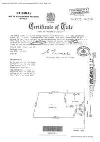
Document - Certificate of Title and Maroondah Heritage Study, "Elouera", 59 Bemboka Road, Warranwood, Victoria, previously part of Crown Section 20, Parish of Warrandyte, County of Evelyn - 4th February, 1987
Property subsequently subdivided into residential allotments with formation of Aspen Court, Warranwood, circa 2010.A4 copies of Landata Victoria documents - Vol 9725 Fol 210 derived from Vol 9701 Vol 469, and 2-page Heritage Study report.Ian Vance Lloyd and June Josephine Lloyd are joint proprietors of an estate in fee simple - Lot 4 on Plan of Subdivision no.204137B shown on the map. Subdivision includes Bemboka Road. Encumbrance E-1 later extended through Lot 4 as Aspen Court. Transfer - Proprietor June Josephine Lloyd - 29 July, 1993. Documents include 2-page Heritage report for study conducted prior to subsequent Aspen Court residential development circa 2010.