Showing 1431 items matching " allotments"
-
 Whitehorse Historical Society Inc.
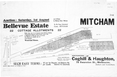
Pamphlet, Bellevue Estate, ca 1927
Land sale of 22 allotments at Mitcham ca 1927 bounded by Barkly Terrace and Church Street.land sales, barkly terrace, mitcham, church street, bellevue estate, coghill & haughton -
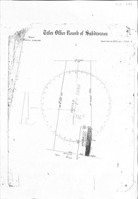
 Ringwood and District Historical Society
Map - Plan of Subdivision, Part of Crown Section 24, Parish of Warrandyte, County of Evelyn - undated, circa 1951
Survey map of residential allotments in Milne Road, east of Berringa Road, Park Orchards, Victoria. -
 Ringwood and District Historical Society
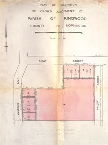
Document, Plan of Subdivision - Part of Crown Allotment 10A, Parish of Ringwood, County of Mornington - 1957
Map of residential allotments in Wantirna Road and Reilly Street, Ringwood, and Philip Street, Heathmont, Vic.Footnote includes "Lots numbered 5 to 11 and 16 to 23 both inclusive are not included in this plan. Signature of Consulting Engineer - Alan J. Brown BCE, LS, MVIS, Licensed Surveyor, Dillons Buildings, 1 Riversdale Road, Camberwell (Phone) WF3528 dated 1-4-1957. -
 Ringwood and District Historical Society
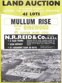
Flyer, Land Auction Advertisement, Mullum Rise, Ringwood - 1970
Double sided leaflet with aerial view of part of Ringwood showing subdivision site, terms of sale, layout of streets and allotments, and summary of local features and services. Additional printout of map with handwritten real estate sales notations includes prices for some allotments.Land auction, Saturday, 10th October (1970). 45 home sites. Subdivision includes Mullum Mullum Road, Hugh Street, Rollington Drive, Cassandra Court, and Jeffrey Drive. Surveyors - R.G. Lee Pty. Ltd., 6 Davis Street, Richmond. Agents - N.R. Reid & Co., 173 Coleman Parade, Glen Waverley, (Telephone) 560 0355 A.H. 560 0361 and Safeway Centre, Boronia Road, Boronia, (Telephone) 762 1022 A.G. 795 2887, also at East Malvern and Mount Waverley. -
 Kew Historical Society Inc
Plan - Subdivision Plan, High Street, Kew, 1920-1935
Pru Sanderson, in her groundbreaking ‘City of Kew Urban Conservation Study : Volume 2 - Development History’ (1988), summarised the periods of urban development and subdivisions of land in Kew. The periods that she identified included 1845-1880, 1880-1893, 1893-1921, 1921-1933, 1933-1943, and Post-War Development. These periods were selected as they represented periods of rapid growth or decline in urban development. An obvious starting point for Sanderson’s groupings involved population growth and the associated economic cycles. These cycles also highlighted urban expansion onto land that was predominantly rural, although in other cases it represented the decline and breakup of large estates. A number of the plans in the Kew Historical Society’s collection can also be found in other collections, such as those of the State Library of Victoria and the Boroondara Library Service. A number are however unique to the collection.The Kew Historical Society collection includes almost 100 subdivision plans pertaining to suburbs of the City of Melbourne. Most of these are of Kew, Kew East or Studley Park, although a smaller number are plans of Camberwell, Deepdene, Balwyn and Hawthorn. It is believed that the majority of the plans were gifted to the Society by persons connected with the real estate firm - J. R. Mathers and McMillan, 136 Cotham Road, Kew. The Plans in the collection are rarely in pristine form, being working plans on which the agent would write notes and record lots sold and the prices of these. The subdivision plans are historically significant examples of the growth of urban Melbourne from the beginning of the 20th Century up until the 1980s. A number of the plans are double-sided and often include a photograph on the reverse. A number of the latter are by noted photographers such as J.E. Barnes.A roughly drawn and faded actual or projected subdivision of a parcel of land bordering on High and Mary Streets. The plan shows five allotments facing High Street and at their rear, another allotment facing Mary Street. In 1906, when the Board of Works surveyors completed Detail Plan 1589, the allotment in Mary Street is shown to include a building. The section of land attached to this building is shown to be undeveloped, thus making a further subdivision possible.subdivision plans - kew, high street -- kew (vic.), mary street -- kew (vic.) -
 Federation University Historical Collection
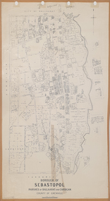
Plan, Borough of Sebastopol, 1940, 01/07/1940
Sebastopol became a suburb of the City of Ballarat.Plan showing the streets, allotments creeks in the Borough of Sebastopol, Parishes of Ballaarat and Cardigan, County of Grenville, in 1940. sebastopol, t. rider, yarrowee creek, leigh river, st george's reserve, leigh creek, sebastopol public gardens, sebastopol recreation reserve, gravel reserve, night soil depot, sanitary depot, rubbish depot -
 Whitehorse Historical Society Inc.
Document, Crown Allotment
Land documents relating to Crown Allotment 116 Shady Grove Nunawading Parish of Nunawading County of BourkeLand documents relating to Crown Allotment 116 Shady Grove Nunawading Parish of Nunawading County of BourkeLand documents relating to Crown Allotment 116 Shady Grove Nunawading Parish of Nunawading County of Bourkeland titles, holmes, dave, shady grove nunawading no.76, helen, jobbins, thomas, the freehold investment and banking company of australia ltd, wilson, david duncan butchart, boyle, walter, holbery, emily rachel, fisher, james cowley morgan -
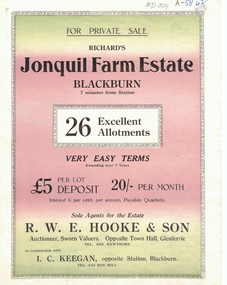 Whitehorse Historical Society Inc.
Document, Jonquil Farm Estate
Brochure of Richard's Jonquil Farm EstateBrochure of Richard's Jonquil Farm Estate featuring 26 allotments, 7 minutes from Blackburn Station.Brochure of Richard's Jonquil Farm Estate land subdivision, jonquil farm estate blackburn, laurel grove, blackburn, boongarry avenue, main street, linum street, hooke, r.w.e. & son, keegan, i.c. -
 Beechworth Honey Archive
Hand-Drawn Diagram of Land by Frank Lebbell Frost September 1920
Hand-drawn diagram of land at Dookie by Frank L. Frost. Depicts plan od three allotments.hand drawn, hand-drawn, plan, land, dookie, frost, beekeeper, beechworth honey -
 Canterbury History Group
Ephemera - Maling Road Canterbury, c1900
Copy of the brochure for the sale of ten allotments on the south side of Maling Road by the Equity Trustees Company c1900.canterbury, maling road, bryson street, equity trustees company limited -
Port Melbourne Historical & Preservation Society
Plan - Photographic copy, Plan of allotments marked at Sandridge, 1849, Lindsay Clarke, Surveyor, c. 1849
Photographic copy of 'Plan of allotments marked at Sandridge in the Parish of South Melbourne; by surveyor Lindsay Clarke 1849On back, '7' in inktown planning, business and traders - hotels, lindsay clarke, wilbraham frederick evelyn liardet, wfe liardet -
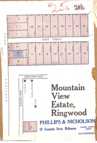 Ringwood and District Historical Society
Map, Partially Trimmed Copy of Mountain View Estate Subdivision Advertisement, Ringwood, Vic. - (Undated, circa 1930s)
Clipped subdivision map on cardboard backing. 22 residential allotments on Daisy Street and Wantirna Road, Ringwood.Auctioneers - Phillips & Nicholson, 59 Swanston Street, Melbourne. Phone Central 10907. -
Clunes Museum
Map, A.C. BROOKS GOVERNMENT PRINTER MELBOURNE, EGLINTON COUNTY OF TALBOT, 1965
MAP OF EGLINTONMAP OF EGLINTON, COUNTY OF TALBOT PRINTED ON CANVAS WITH PLASTIC TAB FOR HANGING. MAP SHOWS TOWN ALLOTMENTSADMINISTRATIVE STAMP ON BOTTOM LEFT AND ON THE BACK OF THE MAP ANOTHER STAMP - NORTHERN DIVISION (299) FORESTS COMMISSION BENDIGOeglinton, historical map -
Bendigo Historical Society Inc.
Map - CAMPBELL COLLECTION: BENDIGO AND DISTRICT MAPS
... allotments ...Map. Mandurang, Parish of Mandurang. Scale 20 chains to 1 inch. Total area 5993 acres. Northern Railway. (number 395 in map cupboard 1)map, bendigo, allotments -
Bendigo Historical Society Inc.
Map - CAMPBELL COLLECTION: BENDIGO AND DISTRICT MAPS, 16-4-29
... allotments ...Map. Kennington, Parishes of Sandhurst, Mandurang and Strathfieldsaye. Scale 20 chains to 1 inch. Total area 2918 acres. Prepared in W.P.B. from A. and C.L. Plans by W.J.Galbraith, 16-4-29. (number 394 in map cupboard 1)W.J.Galbraithmap, bendigo, allotments -
Bendigo Historical Society Inc.
Map - CAMPBELL COLLECTION: BENDIGO AND DISTRICT MAPS, 8-6 29
... allotments ...Map. Kimbolton, Parishes of Kimbolton and Lyell, scale 20 chains to 1 inch. Area by Plamimeter 6258 acres. Coliban River, Knowsley, Strathfieldsaye 10 1/2 miles. Prepared in W.P.B. from Parish and Assessor's Plans. G.W.Latimer 8-6-29. (number 393 in map cupboard 1)G.W.Latimermap, bendigo, allotments -
Bendigo Historical Society Inc.
Map - CAMPBELL COLLECTION: BENDIGO AND DISTRICT MAPS
... allotments ...Map. Eaglehawk, Parishes of Huntly and Nerring. Scale 20 chains to 1 inch. Total area 6211 acres. Eaglehawk Kerang Railway, to Epsom 2 miles. Manure Depot. (number 390 in map cupboard 1)map, bendigo, allotments -
Bendigo Historical Society Inc.
Map - CAMPBELL COLLECTION: BENDIGO AND DISTRICT MAPS, 22-3-29
... allotments ...Map. Marong, Parishes of Marong, Lockwood and Mandurang, Scale 20 chains to 1 inch, Total area 5106 acres. Crusoe Reservoir & Viaduct and water race. Compiled in W.P.B. fro Field Survey and Parish Plans. B.W.L.22-3-29 (number 389 in map cupboard 1)B.W.L.map, bendigo, allotments -
Bendigo Historical Society Inc.
Map - CAMPBELL COLLECTION: BENDIGO & DISTRICT MAPS, 22-3 29
... allotments ...Map. Marong, Parishes of Marong, Lockwood and Mandurang. Scale 20 chains to an inch. Total area 5106 acres. Crusoe Reservoir on right. Compiled in W.P.B. from Field Survey and Parish Plans (number 373 in map cupboard 1)G.W.Lmap, bendigo, allotments -
Bendigo Historical Society Inc.
Map - CAMPBELL COLLECTION: BENDIGO AND DISTRICT MAPS
... allotments ...Map. Eaglehawk, Parishes of Huntly and Nerring. Scale 20 chains to 1 inch. Total area 6211 acres, Bottom left is Eaglehawk Kerang Railway line. IN PENCIL Euc areas 1974, Laurie C.Raynor Comp 13,14,15. J & T Pierce 1,9,8. The use of sticky tape on joins. Sand heaps from Moon Mine. (number 369 in map cupboard 1)map, bendigo, allotments -
Bendigo Historical Society Inc.
Map - CAMPBELL COLLECTION: BENDIGO AND DISTRICT MAPS, 11-4-29
... allotments ...Map. Huntly, Parishes of Huntly, Nerring and Neilborough. Scale 20 chains to 1 inch. Total area 4738 acres. Prepared in W.P.B. from A and C.L. Plans by W.J. Galbraith 11-4-29. Eaglehawk. IN PENCIL top right of map: Euc areas 1974 Scott & Cole Comp 5,6,7,8,9,12,13. Laurie C.Raynor 10,11,17, Part 16 South of Scotsmans Track, J.T Pierce 14,15,16 North of Scotsman Track. From Neilborough. G.Ward. A.Sloan. K.Walker at bottom of map. (number 368 in map cupboard 1)W.J.Galbraithmap, bendigo, allotments -
Bendigo Historical Society Inc.
Map - CAMPBELL COLLECTION: BENDIGO AND DISTRICT MAPS, 8-7-29
... allotments ...Map. Rifle Range, Parishes of Wellsford and Sandhurst. Scale 20 chains to 1 inch. Total area by Planimeter 5916 acres. Wallan and Bendigo Railway line. Rifle Range. Axedale township and station 8 miles. To Longlea Ryl station 2 1/2 miles. To Epsom 1 1/2 miles. To Bendigo 3 miles. Compiled in W.P.D. from Assessment and Parish Plans by H.A.D 8-7- 29 (number 367 in map cupboard 1)H.A.D.(H.A.Darby)map, bendigo, allotments -
Bendigo Historical Society Inc.
Map - CAMPBELL COLLECTION: BENDIGO AND DISTRICT MAPS, 16-5-29
... allotments ...Map. Egerton, Parishes of Egerton and Whirrakee. Scale 20 chains to 1 inch. Total area 5401 acres. Prepared in W.P.B. from A. and C.L. Plans by W.J.G. 16-5-29. To Rochester 12 miles. (number 366 in map cupboard 1)W.J.G.(W.J.Galbraith)map, bendigo, allotments -
Bendigo Historical Society Inc.
Map - CAMPBELL COLLECTION: BENDIGO AND DISTRICT MAPS
... allotments ...Map. Kimbolton, Parishes of Kimbolton and Lyell, scale 20 chains to 1 inch. Area by Planimeter 6258 acres. Knowsley. 10 1/2 miles to Strathfieldsaye. Campaspe River at bottom right of map. (number 365 in map cupboard 1)map, bendigo, allotments -
Bendigo Historical Society Inc.
Map - CAMPBELL COLLECTION: BENDIGO AND DISTRICT MAPS, 16-4-29
... allotments ...Map. Kennington, Parishes of Sandhurst, Mandurang and Strathfieldsaye. Scale 20 chains to 1 inch. Total area 2918 acres. Bendigo 2 1/2 miles. Prepared in W.B. from A.and C. L. Plans by W.J. Galbraith, 16-4-29. (number 364 in map cupboard 1)W.J.Galbraithmap, bendigo, allotments -
Bendigo Historical Society Inc.
Map - CAMPBELL COLLECTION: BENDIGO AND DISTRICT MAPS
... allotments ...Map. Mandurang, Parish of Mandurang, Scale 20 chains to 1 inch. Total area 5993 acres, Northern Railway to left of map, Water Reserve (Spring Gully). (number 363 in map cupboard 1)map, bendigo, allotments -
Bendigo Historical Society Inc.
Map - CAMPBELL COLLECTION: BENDIGO AND DISTRICT MAPS
... allotments ...Map. Lockwood, Parishes of Lockwood and Shelbourne, scale 20 chains to 1 inch. Spring Creek centre of map and Bullock Creek to the right. Total area 4405 acres. (number 358 in map cupboard 1)map, bendigo, allotments -
Bendigo Historical Society Inc.
Map - CAMPBELL COLLECTION: BENDIGO AND DISTRICT MAPS, 1929
... allotments ...Map. Campaspe, Parish of Kimbolton. Total area 4117 acres. Campaspe River, Kimbolton. Scale 20 chains to 1 inch. Prepared in W.P.B. form Parish and Assessment Plans. G.W.L. 9-4-29. (number 351 in map cupboard 1)map, bendigo, allotments -
Bendigo Historical Society Inc.
Map - CAMPBELL COLLECTION: BENDIGO AND DISTRICT MAPS
... allotments ...Map. Longlea, Parishes of Eppalock and Axedale. Scale 20 chains to 1 inch. Total area of map 2372 acres, with Bendigo 9 1/2 miles away. H.A. Darby 18-6-29. (number 349 in map cupboard 1)H.A Darbymap, bendigo, allotments -
Bendigo Historical Society Inc.
Map - CAMPBELL COLLECTION: BENDIGO AND DISTRICT MAPS
... allotments ...Map. Block plan key, Bendigo and surrounding districts including : Sandhurst, Nerring, Huntly, Neilborough, Salisbury, Yarrayne, Bridgewater, Yarraberb, Derby, Leichardt, Tarnagulla, Marong, Woodstock, Shelbourne, Lanecoorie, Lockwood, Ravenswood, Mandurang, Sedgwick, Kimbolton, Eppalock, Strathfieldsaye, Axedale, Wellsford, Ellesmere, Bagshot, Goornong, Nolan, Whirrakee, Egerton, Minto. (number 347 in map cupboard 1)map, bendigo, allotments