Showing 3431 items
matching distances
-
 Phillip Island and District Historical Society Inc.
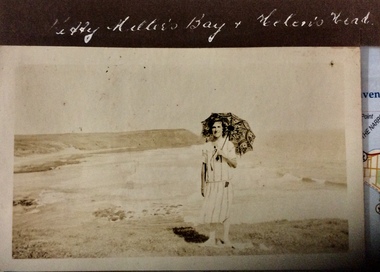
Photograph, Kitty Miller Bay and Helen’s Head, 1925-1926
Sepia photograph of a woman with a parasol, standing on a grassy area above a wide bay with a headland in the distance.Kitty Millers Bay and Helen’s Headphotographs, kitty miller bay phillip island, helen’s head, phillip island -
 Glenelg Shire Council Cultural Collection
Slide - Slide - Cashmore Airport, Portland, 1980s
Coloured slide. Side view of runway site. Several earth moving/vehicles/trucks in distance.portland airport, cashmore airport, portland development, construction -
Glenelg Shire Council Cultural Collection
Slide - Slide - Cashmore Airport, Portland, 1980s
Coloured slide. Side view of runway site. Several earth moving/vehicles/trucks in distance.portland airport, cashmore airport, air travel, construction, engineering -
Glenelg Shire Council Cultural Collection
Negative - Glass Plate Negative - Tennis Courts in Botanic Gardens, 1890-1910
Glass plate negative. Tennis Courts in Botanic Gardens with 'Kingsley' (obscured by trees) on the hill in the distance.Front: 'Portland' -
 Bendigo Historical Society Inc.
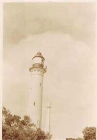
Photograph - PHOTOGRAPH COLLECTION: LIGHT HOUSES
Photograph 8 - Sepia photo of 2 light houses, one close up and the other in the distance.photograph, landscape, photograph, landscape, lighthouse, burrowes st., golden square collection. -
Port Melbourne Historical & Preservation Society
Book - Maritime handbook, F G Strang, F G Strang Pty Ltd, 1940s
Complimentary book by F.G.Strang setting out stowage weights, sea distances, weight and measure tables.maritime, melbourne harbor trust - port of melbourne authority, f g strang -
 Benalla Art Gallery
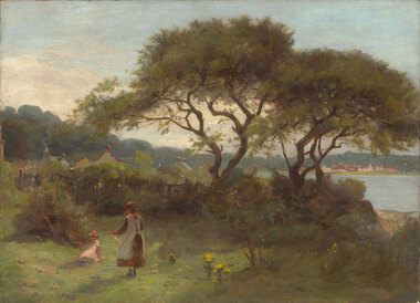
Painting, UNKNOWN, Untitled, 1885
Born: Dorchester, Dorset, England 1856; Arrived: Melbourne, Victoria, Australia 1869; Lived and worked: Spain, England, France 1883-1885; Died: Kallista, Victoria, Australia 1931ImpressionismGift of Wooleen Pty. Ltd., 1980Seaside Landscape with small figures playing and trees, water, grass, flowers and buildings in the distance. Unframed.Recto: Signed and dated "Tom Roberts / 1888" in mauve oil in l.r.c of composition; Not titledpainting, landscape, trees, figures, buildings, colonial, children, flowers -
Tatura Irrigation & Wartime Camps Museum
Photograph - copy, copy 1989
Light horse guard and mount on duty.B & W. Light horse guard mounted on horse. Rifle in holster. Buildings and trees in distance.light horse guard, internment camps, internment camp 13 -
 Tatura Irrigation & Wartime Camps Museum
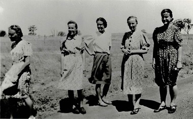
Photograph, Vollmer Sisters
Vollmer sisters were internees at Camp 3 during WW2. Left to right: Aline Zollinger (married a Vollmer), Traude, Hedwig, Lydia and Ruth VollmerBlack and white photograph of 5 women standing, couple of trees in the distance behind the women on the right. aline zollinger, aline vollmer, traude vollmer, hedwig vollmer, lydia vollmer, ruth vollmer -
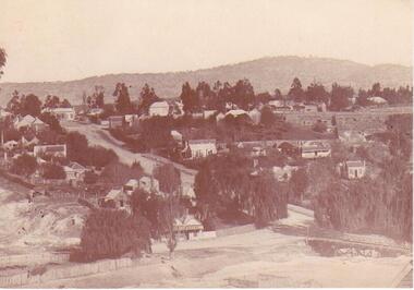 Clunes Museum
Photograph
SEPIA PHOTOGRAPH OF CLUNES TOWNSHIP - showing Camp Hill and the Commercial Hotel. Mt Beckworth in distance. local history, photography, photographs, clunes township -
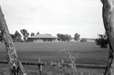 Hume City Civic Collection
Photograph, Bulla Sports Ground, 1990
The Bulla Sports Ground, along with the clubrooms and community centre were updated in 1990. Prior to then they were used for various district sporting events but over the years they were becoming run down. They are sited in Green Street. Over the years many local sporting competitions have taken place on the Bulla Sports Ground and has been a focal point for the town's activities.A black and white photograph of a sports oval with a building in the distance. A wooden post and rail fence is in the foreground.bulla sports ground, green street -
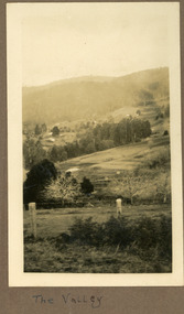 Mt Dandenong & District Historical Society Inc.
Photograph
The photograph is from the album of Ivy May Child. The scene is looking down across the Kalorama Valley in the early 1930s. Probably across the Jeeves and Child properties. Ivy May Child (1910 – 1989) was the daughter of Arthur Edward (Ted) Child (1878 – 1964) and Ethel May Madden (1888 – 1970). Ted Child was the son of Matthew Francis Child (1839 – 1933) and Martha Jeeves (1857 – 1926). He was the grandson of one of the early pioneers Francis Child. Ivy grew up on the family property on Childs Road and took many photographs. Most of these are glued into her photo album. The album covered the years from c1927 – 1932. Ivy married Henry William Burgess (1906 – 1968) in 1944. The photographs remain in their original state in the album with individual copies made. Black and white photograph with a post and wire fence in the foreground , hills in the distance and a cultivated area in the centre.Written below the photograph in the album: The Valleyjeeves, child, kalorama valley, kalorama, valley -
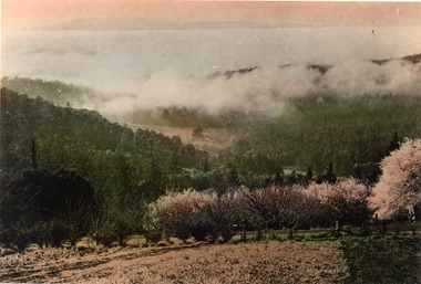 Mt Dandenong & District Historical Society Inc.
Photograph, Cloud Settling Into Hills
Looking into the Kalorama Valley with an orchard in the foreground and cloud settling into the hills.Coloured photograph looking down valley with flowering fruit trees in foreground and treed hills in distance.kalorama, kalorama valley, orchard -
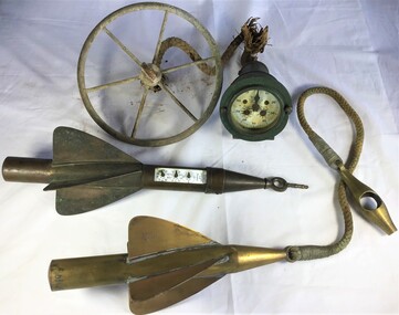 Queenscliffe Maritime Museum
Instrument - Trailing Ship's Log
Used to 1935 by John Gordon Hanby while in the militia at Fort Queenscliffe.Metal trailing log comprising of a gauge and two rotors towed behind ships to measure distance.Walker's, Cherve, Mark III.towing log, measuring distance, ship's log -
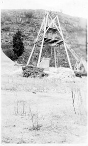
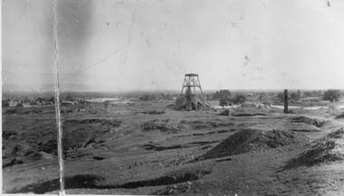 Stawell Historical Society Inc
Photograph, Sloane's & Scotchmans Mining Co's Remains of Poppet Head, Chimney & Engine Mounts. 1928
Sloane's & Scotchman Mining Co remains Poppet Head Chimney and Engine Mounts.Damaged B/W image showing heavily eroded mining area with mine at centre distance. mining, panorama -
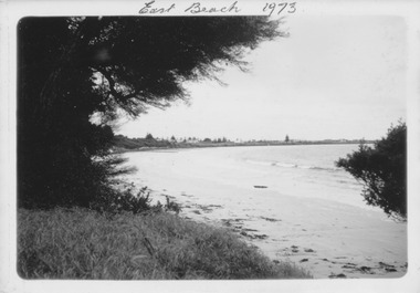 Port Fairy Historical Society Museum and Archives
Photograph
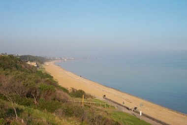
East Beach 1973Black and white photograph of East Beach with she oaks on the left and Norfolk Island pine in distanceNovember 1973 kodakeast beach, battery hill, ocean, sea, sand -
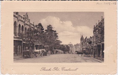 Camberwell Historical Society
Postcard - Photo postcard, Postcard of Bourke Road, Camberwell, Unknown date but postcard probably dated circa 1900 - definitely pre 1913 because in that year gas lamps were removed from main roads, intersections, also street trees in Burke Road. Also no cars are visible on the street, only horses and carriages. In March 1894 the first streets in the central city of Melbourne were lit with electricity
Undated photograph on postcard depicting horses and carts with gas lamp in the distance on Bourke Road, Camberwell. Front of postcard: 'Bourke Road, Camberwell' Back of postcard: 'Post Card' 'This side for correspondence' 'This side for address' 'Stamp here' 'Printed in Germany.' Handwritten notes '22649 $20'camberwell, bourke road -
 City of Kingston
Photograph - Digital image, Colour, City of Kingston (Graham Whitehead)
Colour image of Mentone foreshore looking towards Mordialloc. The natural environment of Kingston significantly impacted its development. The bay was a source of food and income, as well as a holiday destination. Colour image of Mentone beach looking towards Mordialloc, with Mentone life saving club in distance.mentone, beach, environment -
 Sunbury Family History and Heritage Society Inc.
Photograph, Lydia Keyworth, The Nook, March 2001
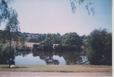
The photograph was included in a completion organised by the former Sunbury & District Heritage Association in March 2001. It is photograph of the lake at The Nook that served as Sunbury's swimming pool from the time outdoor swimming became acceptable until 1965 when a new Olympic sized outdoor swimming pool and aquatic centre was opened in Ligar Street. The modern pool was built as a result of the Sunbury Community raising funds for the project. Since 1965, the local council has added an indoor pool and a heated pool to the site as well as a gymnasium. Prior to the building of the new pool in 1965, The Nook site was where swimming carnivals and other aquatic events took place. It is now a popular passive recreation area.A non-digital coloured photograph of a lake with trees growing around its banks and a hillside in the distance.the nook, swimming, swimming clubs, sunbury -
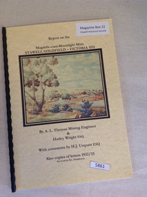 Stawell Historical Society Inc
Book, A.L. Thomas & Harley Wright, Report on the Magdala-Cum-Moonlight Mine Stawell Goldfield Victoria 1931
Report on the Magdala cum Moonlight Mine 1931 By A.L. Thomas & Harley WrightYellow card cover with colour picture of bushland with a mine in the mid distance. Picture by R.L. Henderson.Report on the Magdala-cum-Moonlight Mine Stawell Goldfield - Victoria 1931 By A.L. Thomas Mining Engineer & Harley Wright Esq. With Comments by H.J Urquart Esq Also copies of letters 1932/33 Artwork by R.L. Hendersonstawell gold mining -
 Linton and District Historical Society Inc
Photograph, Gold Mine at Devil's Kitchen, Piggoreet
Looking south into Devil's Kitchen, Piggoreet with the Woady Yallock River dry bed. This photograph was originally thought to be of the Try Again Mine, however information from Joan Hunt in 2015 suggests this is the Port Arthur No. 1 Mine, located between the Devil's Kitchen and the Grand Trunk MineSmall black and white original photograph of dry creek bed with mine poppet head in distance."1920s-1930s/Devils Kitchen/Piggoreet".try again mine, port arthur no. 1 mine, devil's kitchen, piggoreet, mining, mines -
 Lakes Entrance Historical Society
Photograph, M Holding, Boardwalk Metung Victoria, 1/11/1999 12:00:00 AM
Colour photograph of Metung Rock in the lake between the boardwalk and Marina, in distance the village of Metung Victoriapublic works, waterfront -
 Hume City Civic Collection
Photograph, early 1980s
Gellibrand Hill along with the surrounding 3 properties: Attwood, Cumberland and Woodlands were incorporated into Gellibrand Park during the 1980s. Tullamarine became Melbourne's main air terminal in 1970 and replaced Essendon Airport.A coloured landscape photograph with rounded corners of the Tullamarine Airport taken from Gellibrand Hill. A man with his back to the camera is on the RHS and another person is running down the hill on the LHS. The area in the middle distance is lightly treed and the airport is in the distance to the right of the photograph.gellibrand hill, tullamarine airport, george evans collection -
 Lakes Entrance Historical Society
Postcard - Bullock Island Lakes Entrance, H D Bulmer, 1950 c
Bullock Island and first traffic bridge. Bullock Island has no development. North Arm bridge and Princes Highway in foreground, New Works area across Cunninghame Arm in distance Lakes Entrance Victoria. Also a cut down colour photograph of second humpy bridge to Bullock Island donated by M Fish number 04208.1 size 3 x 13 cm|Also two black and white photographs numbers 04208.2 and 04208.3 in SparesColour tinted postcard of Bullock Island and first traffic bridge. Bullock Island has no development. North Arm bridge and Princes Highway in foreground, New Works area across Cunninghame Arm in distance Lakes Entrance Victoria. Also a cut down colour photograph of second humpy bridge to Bullock Island donated by M Fish number 04208.1 size 3 x 13 cm|Also two black and white photographs numbers 04208.2 and 04208.3 in Spares Bullock Island and Bridge Lakes Entrance waterways, gippsland lakes, islands, vegetation -
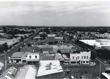 Bendigo Historical Society Inc.
Photograph - AERIAL VIEW BENDIGO, 1995
Black and white photograph: city skyline taken from St. Pauls's, Mitchell St. in foreground ( left to right ) Wills St. on RHS ( to distance ) and Garsed St. on LHS ( to distance ) Edwards St. ( next street parallel to Mitchell St. ( Noelene Wild 7.2000 )Peter Hyettplace, aerial view of bendigo -
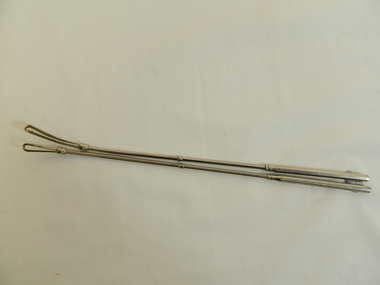 Kiewa Valley Historical Society
Tonsil Snare x 2
This medical instrument was used in the Tawonga District General Hospital which was built in the 1950s specifically for the increase in population due to the Kiewa Hydro Scheme.Historical: Shows the development of scientific hospital equipment. Provenance: Used in the Tawonga District General Hospital which was remote and therefore required good equipment.Stainless steel rods split at one end into a loop. Along rod is a slight shield as if to mark a distance.medical instrument. hospital equipment. tonsil. tawonga. mt beauty. -
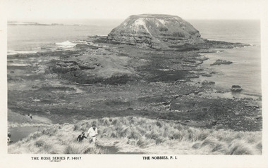 Phillip Island and District Historical Society Inc.
Photograph, Rose Series
Postcard found by Lynne Allen at her late Aunt's house in 2013. Lynne Allen President of the Shoalhaven Historical Society NSWBlack & White postcard of The Nobbies. Man and boy walking along a dirt pathway. Seal Rocks in the distance.The Rose Series P. 14017. The Nobbies, P. I. the nobbies phillip island, shoalhaven historical society, lynne allen -
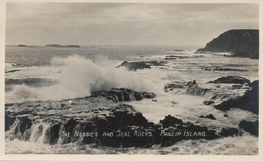 Phillip Island and District Historical Society Inc.
Photograph - Post Card, 1900
Donated by Edith ElmsBlack & White Postcard of sea crashing onto Seal Rocks with The Nobbies in background and Western Port in the distance."The Nobbies and Seal Rocks. Phillip Island. 4."the nobbies phillip island, seal rocks phillip island, phillip island, edith elms -
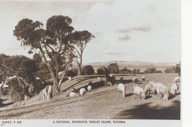 Phillip Island and District Historical Society Inc.
Photograph, Unknown
One of 20 photographs/postcards donated by Mary KarneyBlack & White copy of a postcard showing sheep grazing on pasture in Newhaven Phillip Island, with gentleman in the distance."The Rose Series P. 685" "A Pastoral, Newhaven, Phillip Island, Victoria"pastoral scene, newhaven pasture, sheep, phillip island, mary karney -
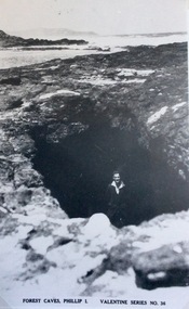 Phillip Island and District Historical Society Inc.
Photograph, Forrest Caves, Phillip island
Part of a collection of 'Rose & Valentine' series of Post Cards. Copied by John Jansson 1984View of Forrest Caves on Phillip Island, with man standing inside a cave. Cape Woolamai seen in the distance.Forest Caves, Phillip Island. Valentine Series No.36local history, photography, photographs, postcards, black & white postcard copy, forest caves, cape woolamai, phillip island