Showing 1938 items
matching floods
-
 Charlton Golden Grains Museum Inc
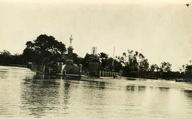
Photograph, War Memorial 1933 Flood
1933 Flood, War Memorial Charlton with Mechanics Institute behind.War Memorial 1933 flood with Mechanics Institute in backgroundflood, charlton, mechanics institure, war memorial -
 Charlton Golden Grains Museum Inc
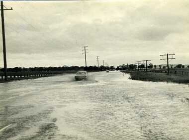
Photograph, Charlton Tribune, 1973 Flood, Nov 1971
1971 flood, Car driving through flood water on Calder Highway, Charlton, VictoriaB/W photograph of 1971 flood. Car driving through floodwater on Calder Highway.flood, calder highway -
 Eltham District Historical Society Inc
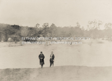
Photograph, Diamond Creek in flood 1924, 1924
... floods ...Colour photograph of original showing Diamond Creek in flood at Eltham 1924floods, diamond creek, eltham -
 Charlton Golden Grains Museum Inc
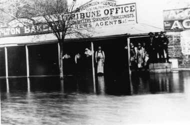
Photograph, Flood High Street Charlton outside Tribune Office
Flood in High Street Charlton. People standing in front of Charlton Tribune Office.Flood High Street Charlton outside Tribune Officeflood, charlton tribune, charlton -
 University of Melbourne, Burnley Campus Archives
Slide, Alan L. Mitchell, 1934
... floods ...Floods in Orchard 1934 from Yarra River.alan l. mitchell, burnley gardens, floods, orchard -
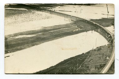 Orbost & District Historical Society
black and white photographs, second half 20th century
3154.1 is a postcard of the Orbost viaduct over the flooded Snowy River flats. 4153.2 is of a goods train on the viaduct. 3154.3 is of a loaded goods train with the driver at the window. Two men are standing on the plate and there are two workers below where there is some water and flood debris. 3154.4 is of amachine moving flood debris on the rail line. 3154.5 shows flood damage to the viaduct across the Snowy River flats. Two men are driving a dozer.This item is associated with the history of the Orbost-Bairnsdale railway line and therefore reflects the role that the rail line played in the social and economic history of Orbost.Five black / white photographs associated with the Orbost railway line during a flood.orbost-railway east-gippsland -railway orbost-floods -
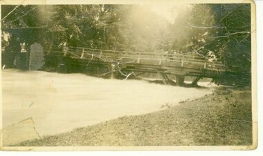
Clunes Museum
Photograph, 2010
... Floods ....1 Bridge was damaged and closed for repairs for about 6 months .2 Government bridge is higher and was not damaged.1 colour photograph of flooded creek at the newer bridge, water is hitting the bridge .2 colour photo of Government bridge during the floods, water is below the top of the bridge.1 T. Goldworthy 4th Sept. 2010 about midday .2 T. Goldworthy 4th Sept. 2010 about middaybridges, floods, photograph, goverment bridge -
 Charlton Golden Grains Museum Inc
Photograph, Barber, Mr, c. 1933
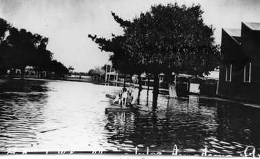
1933 Flood, in Armstrong Street, Mr Barber and dog in boat.1933 flood in Armstrong Street. Mr Barber and dog in boat.flood, charlton -
 Charlton Golden Grains Museum Inc
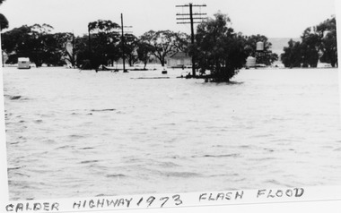
Photograph, B/W photograph 1973 Flash Flood on Calder Highway
1973 Flash Flood on Calder HighwayUnframed B/W photograph 1973 Flash Flood on Calder Highwayflood, charlton, calder highway -
 Kew Historical Society Inc
Photograph - Flood, Zig-Zag, Kew, 1924
Henry Beater Christian (1886-1962) , was a descendant of one of the earliest settler families in Kew. Employed at the Kew Asylum as a 'public servant', he was a skilled amateur photographer, photographing numerous scenes in Kew and on his travels around Victoria. The majority of his photographs date from 1916 to 1929. His finest photographs are housed in two photograph albums. Digital copy of a photograph from page 5 of the 47-page photograph album containing 261 gelatinous silver images, loaned by Diane Washfold with permission given to digitise and hold a copy in our collection. This is a photograph of the river at Kew during a flood in January 1924. A section of the Zig-Zag Bridge can be seen in the distance. "Flood / Zig-Zag Kew / 1.24"henry beater christian (1886-1962), landscape photography, kew (vic.) — yarra river, christian-washfold collection, photograph albums, floods -- yarra river -- kew (vic.), zig-zag bridge -
Peterborough History Group
Newspaper articles pertaining to Peterborough from 1990 to 1999
... floods ...Various newspaper articles kept by Mrs Dawn Irvine, all pertaining to Peterborough - river flooding and quality, concerns over council boundary realignment. Article titles: 6/10/1992 Flooding at Peterborough 28/6/1994 Residents undecided over River 4/7/1994 Letter from Warren Moore. Peterborough is alive, the way residents like it. 26/12/1994 Letter from R. Irvine. Apprehension over changes 17/6/1998 Algae fear prompts call to open Curdies River 13/4/1999 Battlelines on the Curdies 14/4/1999 Peterborough residents urge BHP to find alternative waste disposal optionHistoric overview of the towns' concerns at that time. Seven newspaper cuttings of various sizes all regarding aspects of Peterborough. Includes objection to BHP discharging waste into the Curdies River and flooding. warren moore, ronald irvine, curdies river, moyne council, council boundary realignment, curdies river flooding, floods, peterborough, blue green algae, river quality, bhp waste management, bhp -
 Eltham District Historical Society Inc
Photograph, George W. Bell, Flood Eltham early 1950's, 1950c
... floods ...Black and white photograph of flood remains Eltham early 1950s.floods, eltham, diamond creek, george w bell collection -
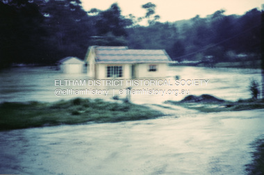 Eltham District Historical Society Inc
Photograph, 1957 flood, Railway Parade, Eltham, 1957
... floods ...Colour photograph of flooded house Railway Parade Eltham 1957floods, diamond creek, eltham, railway parade -
 University of Melbourne, Burnley Campus Archives
Photograph - Black and white print, Orchard in Flood, 1934
... floods ...Black and white photograph. Orchard in flood, shows uprooted trees.orchard, yarra river, floods, 1934 -
 University of Melbourne, Burnley Campus Archives
Photograph - Black and white print, Orchard in Flood, 1934
... floods ...Black and white photograph. Orchard in flood: small shed in the centre.orchard, yarra river, floods, 1934 -
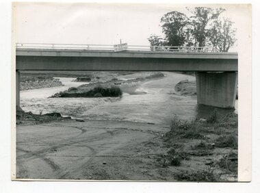
 Charlton Golden Grains Museum Inc
Photograph, Charlton Tribune, 1973 flood at low water bridge
1973 Flood at Charlton, Vic. At the low water bridge.Unframed photograph/ sepia of 1973 flooding of Charlton at low water bridge.flood, low water bridge -
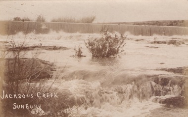 Sunbury Family History and Heritage Society Inc.
Photograph
The river in flood is the Jacksons Creek. This section of the river with the waterfall is downstream from the town of Sunbury.A sepia photograph in post card format of a river with waterfalls in flood.rivers, jacksons creek, sunbury -
 Charlton Golden Grains Museum Inc
Photograph, Charlton Tribune, B/W photograph of 1971 flood, Nov 1971
1971 flood at Charlton. Paddocks and roadside along Calder Highway.Unframed photograph of 1971 flood. Paddocks and roadside along Calder Highway.flood, charlton, calder highway -
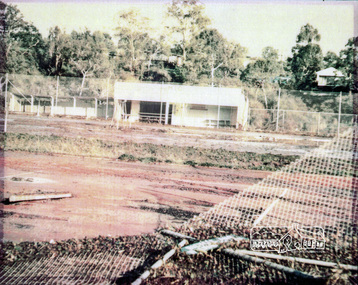 Eltham District Historical Society Inc
Photograph, Montmorency Tennis Club, 1974c
... floods ...Fully laminated colour photograph of Montmorency Tennis Courts after flooding c.1974.tennis courts, montmorency, floods -
 Clunes Museum
Photograph, KODAK, CLUNES FLOOD 1934, 1934
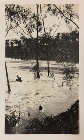
CRESWICK CREEK FLOODED IN 1934. AFTER VERY HEAVY RAINS UP STREAM - WATER REACHED SOLDIER'S MONUMENT AND PURCELL STREET CLUNESBLACK AND WHITE PHOTOGRAPH OF CRESWICK CREEK IN FLOOD. BUTTER FACTORY BRIDGE WITH WATER THREE QUARTERS UP PYLONS. 1934 FLOODS TREES IN QUEEN'S PARK IN BACKGROUND.clunes floods, photograph, creswick creek -
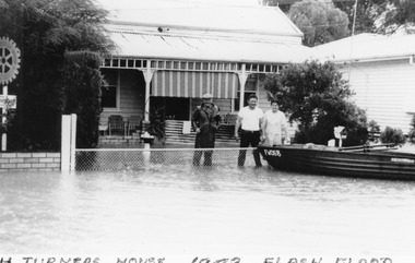 Charlton Golden Grains Museum Inc
Photograph, B/W Photograph of 1973 flood, February 1973
1973 flood. Turner's house in High Street Charlton with boat tethered to the fenceUnframed B/W Photograph of 1973 flood. Turner's house in High Street Charlton with boat tethered to the fence after 10 inches of rain fell overnight at Yeungoon causing a flash floodflood, charlton, high street, turner, flash flood -
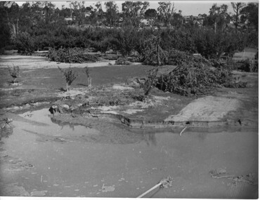
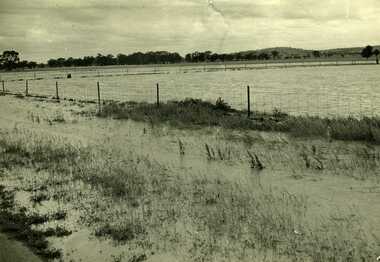
 Orbost & District Historical Society
black and white photographs, October 22 1976
The road to Marlo was cut by flood waters from the Snowy River in two places. The road was closed when water flowed over Gilbert's Gulch (3243.1) The Snowy River broke its banks and flooded surrounding Orbost, Marlo, Lochend and Jarrahmond were isolated. The river bank at the bridge site was broken and filled with earth and rock fill. (3243.2) The new Snowy River Bridge was nearing completion when the river rose 7.2 metres causing erosion on the eastern bank. (3243.7) Contractors involved in the construction of the Princes Freeway and bridge were delayed by the flood waters. (3243.8) The 1976 flood at Orbost was a significant event which delayed the construction of the current Snowy River Road Bridge.These photographs record that event.Nine black / white photographs of flood waters across roads. orbost-flood-1976 snowy-river-bridge marlo-road-flood-1976 gilbert;s-gulch-flood -
 Eltham District Historical Society Inc
Photograph, George W. Bell, Flood Eltham early 1950's, 1950c
... floods ...Black and white photograph of Diamond Creek in flood at Eltham early 1950sfloods, diamond creek, eltham, george w bell collection -
University of Melbourne, Burnley Campus Archives
Document, Improvements (Completed files), 1925-1935
... floods ...Correspondence mainly re drainage, repairs after 1934 floods. etc.drainage, repairs, floods, improvements -
Tatura Irrigation & Wartime Camps Museum
Painting - watercolour - photocopy, Hay Flood 1943, 1943
Drawn by Theo Engel after a flood at Hay war camp 8 in 1943.Photocopy of a watercolour of Hay Flood 1943. 6 Army huts and pathwaystheo engel, hay war camp flood -
 Kew Historical Society Inc
Photograph - Flood, Zig-Zag, Kew, 1924
Henry Beater Christian (1886-1962) , was a descendant of one of the earliest settler families in Kew. Employed at the Kew Asylum as a 'public servant', he was a skilled amateur photographer, photographing numerous scenes in Kew and on his travels around Victoria. The majority of his photographs date from 1916 to 1929. His finest photographs are housed in two photograph albums. Digital copy of a photograph from page 5 of the 47-page photograph album containing 261 gelatinous silver images, loaned by Diane Washfold with permission given to digitise and hold a copy in our collection. This is a photograph of the Zig-Zag Bridge that crossed the river at Kew during a flood in January 1924. The contrast in the photo is compromised because of the weather conditions and due to shooting into the light."Flood / Zig-Zag Kew / 1.24"henry beater christian (1886-1962), landscape photography, kew (vic.) — yarra river, christian-washfold collection, photograph albums, floods -- yarra river -- kew (vic.), zig-zag bridge -
 Kew Historical Society Inc
Photograph - Flood, Zig-Zag, Kew, 1924
Henry Beater Christian (1886-1962) , was a descendant of one of the earliest settler families in Kew. Employed at the Kew Asylum as a 'public servant', he was a skilled amateur photographer, photographing numerous scenes in Kew and on his travels around Victoria. The majority of his photographs date from 1916 to 1929. His finest photographs are housed in two photograph albums. Digital copy of a photograph from page 5 of the 47-page photograph album containing 261 gelatinous silver images, loaned by Diane Washfold with permission given to digitise and hold a copy in our collection. This is a photograph of the river at Kew during a flood in January 1924. The bridge is the Zig-Zag Bridge that linked the Yarra Bend and Kew Asylums (built 1870s-demolished 1929)."Flood / Zig-Zag Kew / 1.24"henry beater christian (1886-1962), landscape photography, kew (vic.) — yarra river, christian-washfold collection, photograph albums, floods -- yarra river -- kew (vic.), zig-zag bridge -
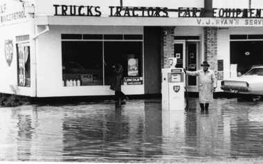 Charlton Golden Grains Museum Inc
Photograph, Charlton Tribune, Unframed B/W Photograph of 1973 flood showing floodwater at Vin Ryan's garage, February 1973
1973 flood showing floodwater at Vin Ryan's garageB/W Photograph of 1973 flood showing floodwater at Vin Ryan's garageflood, charlton, vin ryan, garage, charlton tribune -
 Kew Historical Society Inc
Photograph - Flooding of shared path at rear of Guide Dogs Victoria, 1993
The land currently occupied by Guide Dogs Victoria was once part of the grounds of the Kew Lunatic Asylum. This includes the land, designated as parkland which adjoins the Yarra River. Original colour small format polaroid photograph of flooding in parkland at the rear of Guide Dogs Victoria in the area now used as the Main Yarra Trail; taken on 16 September 1993."Flooding of shared path on 16.9.93 / Rains 15.9.93 - rear Guide Dogs [Victoria] land"yarra river -- floods -- kew (vic.), guide dogs victoria, main yarra trail, chandler park -
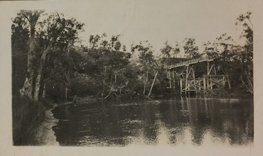
 Kiewa Valley Historical Society
Photos - x2 Damms Road River Crossing
Damms Road river crossing after the c1993 floods of the Kiewa River. The old bridge was inundated, later to be washed away.The Kiewa River flooded in 1993 at Damms Road when the old bridge was washed away.2 coloured photos of the Kiewa River in flood at Damms Roadkiewa river flooding, bridge at damms road