Showing 5109 items matching " housing estate"
-
 Whitehorse Historical Society Inc.
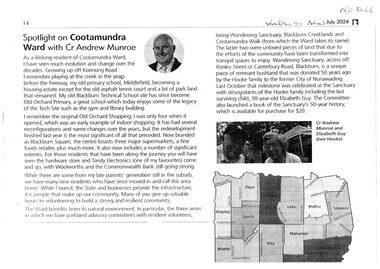
Document, Cootamundra Ward, July 2024
... Cr Munroe explains Middlefield Primary School 1952 - 1992 becoming a housing estate and Blackburn Technical School 1959 - 1992 becoming Old Orchard Primary School in 1995 Also Old Orchard Shopping becoming Blackburn Square...Whitehorse Historical Society Inc. 2-10 Deep Creek Road Mitcham melbourne Cr Munroe explains Middlefield Primary School 1952 - 1992 becoming a housing estate and Blackburn Technical School 1959 - 1992 becoming Old Orchard Primary School in 1995 Also Old Orchard Shopping becoming Blackburn Square Blackburn Square Old Orchard Shopping Centre Blackburn Middlefield Primary School No.4878 Wandinong Sanctuary Blackburn Technical School Blackburn Creekland Old Orchard Primary School No.3130 Cootamundra Walk Munroe Andrew Cr Cr Andrew Munroe reminisces over changes in Cootamundra Ward Cootamundra Ward Document Whitehorse News ...Cr Andrew Munroe reminisces over changes in Cootamundra Wardnon-fictionCr Andrew Munroe reminisces over changes in Cootamundra Wardblackburn square, old orchard shopping centre blackburn, middlefield primary school no.4878, wandinong sanctuary, blackburn technical school, blackburn creekland, old orchard primary school no.3130, cootamundra walk, munroe andrew cr -
 Sunbury Family History and Heritage Society Inc.
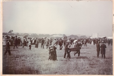
Photograph, Sunbury Racecourse
... The land has been sold and it is now a housing estate. ...The land has been sold and it is now a housing estate. The race meetings in Sunbury were well attended with special trains running from Melbourne on race days. ...The photograph was taken at a Sunbury Race meeting, when a sudden shower of rain caused the spectators to run for cover. Sunbury Race Course was situated along Racecourse Road about 2kms from the railway station. The land has been sold and it is now a housing estate. The race meetings in Sunbury were well attended with special trains running from Melbourne on race days.A non-digital sepia photograph mounted on cardboard of a crowd of people caught in a sudden shower of rain and running for shelter at a race meeting.sunbury race meetings, racecourse road, races, stud farms -
 Sunshine and District Historical Society Incorporated
Administrative record - City of Sunshine - Commissioner Mr Alexander Alex George Gillon Collection 1976 - 1982 - Minutes Of Ordinary Meeting 14th September 1976, City of Sunshine, 14th September 1976
... Conference for Independent and Non- Aligned Australia Reserve Housing Commission Estate Western Region Women's Refuge Purchase present tip site from Albion Reid Pty Ltd...City of Sunshine Alexander "Alex" George Gillon Abion Tip Conference for Independent and Non- Aligned Australia Reserve Housing Commission Estate Western Region Women's Refuge Purchase present tip site from Albion Reid Pty Ltd Foolscap sized document. ...Conference for Independent and Non- Aligned Australia Reserve Housing Commission Estate Western Region Women's Refuge Purchase present tip site from Albion Reid Pty Ltd city of sunshine, alexander "alex" george gillon, abion tip -
 Eltham District Historical Society Inc
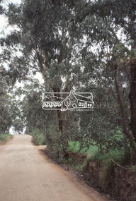
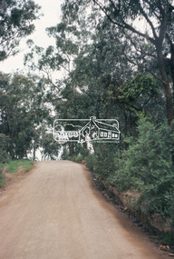
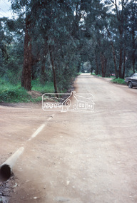
Slide, Maroondah Aqueduct, Research, Victoria, 22 Mar. 1981
... The hills in the distance near the power lines now a housing estate....The hills in the distance near the power lines now a housing estate. activities heritage excursion maroondah aqueduct research (vic.) shire of eltham historical society 35 mm colour positive transparency (1 of 5) Mount - Agfachrome Agfa CS System black 8 dots Maroondah Aqueduct, Research, Victoria Slide Slide ...This view shows the area that would develop into the Research Industrial Estate. In centre distance though largely hidden by trees is the site of the Research Hall, which was later demolished and a new Eltham Little Theatre constructed in 1988 as a bicentennial project. The hills in the distance near the power lines now a housing estate.35 mm colour positive transparency (1 of 5) Mount - Agfachrome Agfa CS System black 8 dotsactivities, heritage excursion, maroondah aqueduct, research (vic.), shire of eltham historical society -
 Hume City Civic Collection
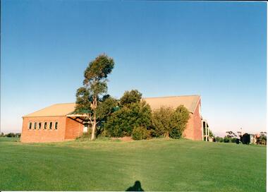
Photograph, early 1980s
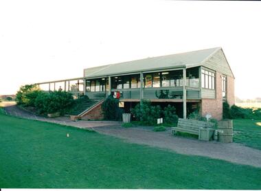
... The golf club was part of the Goonawarra Housing Estate which was developed on the area previously known as Goonawarra Farm. ...The golf club was part of the Goonawarra Housing Estate which was developed on the area previously known as Goonawarra Farm. ...The series of photographs were taken shortly after the opening of the newly established Goonawarra Golf Club in the early 1980s. The golf club was part of the Goonawarra Housing Estate which was developed on the area previously known as Goonawarra Farm. The new golf club replaced 'The Pines' which was part of the Caloola complex.A coloured photograph of the rear of Goonawarra Golf Club's Clubrooms. Along the wall of a small vestibule are 6 narrow casement windows. A native garden is planted along the building with a large grassy area extending downhill from the building.goona warra golf club, george evans collection -
 Sunshine and District Historical Society Incorporated
Photograph - Deer Park ICI Employee's Houses Photograph
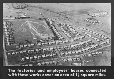
... The Deer Park ICI Employees Housing Estate was built in stages from the 1920s to the 1950s to house workers and managers of the Nobel/ICI explosives and chemical works. ...Brimbank Library, 301 Hampshire Road, Sunshine 3020. melbourne The Deer Park ICI Employees Housing Estate was built in stages from the 1920s to the 1950s to house workers and managers of the Nobel/ICI explosives and chemical works. ...The Deer Park ICI Employees Housing Estate was built in stages from the 1920s to the 1950s to house workers and managers of the Nobel/ICI explosives and chemical works. It is now recognised as a State‑significant company town precinct for its rare surviving examples of employer‑built housing in Victoria. When Nobel merged into ICIANZ (Imperial Chemical Industries of Australia and New Zealand) in 1928, the company expanded the housing program. Sassella Park, centre left was sold to the Shire of Braybrook by Mr. Antonio Sassella in 1925. In December 1929, Sassella Park officially opened as a sports ground, thus Sassella Park predating the ICI housing estate expansion, the post‑war suburban development and the 1950s–60s civic infrastructure boom throughout Deer Park.This photograph captures one of the few purpose‑built industrial housing estates in Victoria. ICI deliberately built a company‑town layout with , Recreation Reserve, Deer Park Hall, the Hunt Club Hotel was used as an ICI training Centre, Social Club and Community Facilities.The factories and Employee's houses connected with these works cover an area of 1 1/2 square milesdumfries street, station road, kynoch street, welwyn parade, downes way, irvine street, slough street, milbank drive, huddersfield road, sassella park, sassella park caretakers house, ici, kororoit creek, deer park -
 Hume City Civic Collection
Photograph, early 1980s
... The golf club was part of the Goonawarra Housing Estate which was developed on the area previously known as Goonawarra Farm. ...The golf club was part of the Goonawarra Housing Estate which was developed on the area previously known as Goonawarra Farm. ...The series of photographs were taken shortly after the opening of the newly established Goona Warra Golf Club in the early 1980s. The golf club was part of the Goonawarra Housing Estate which was developed on the area previously known as Goonawarra Farm. The new golf club replaced 'The Pines' which was part of the Caloola complex.A coloured photograph of the front view of Goonawarra Golf Club's clubrooms. The building is on 2 levels with a large balcony across the front. Native plants have been planted around the building and a gravel path leads to the building.goona warra golf club, george evans collection -
 Hume City Civic Collection
Photograph, early 1980s
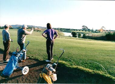
... The golf club was part of the Goonawarra Housing Estate which was developed on the area previously known as Goonawarra Farm. ...The golf club was part of the Goonawarra Housing Estate which was developed on the area previously known as Goonawarra Farm. ...The series of photographs were taken shortly after the opening of the newly established Goona Warra Golf Club in the early 1980s. The golf club was part of the Goonawarra Housing Estate which was developed on the area previously known as Goonawarra Farm. The new golf club replaced 'The Pines' which was part of the Caloola complex.A coloured photograph of 3 men who are looking towards the lake at the Goonawarra Golf Club. Their golf buggies are behind them.goona warra golf club, george evans collection -
 Hume City Civic Collection
Photograph, early 1980s
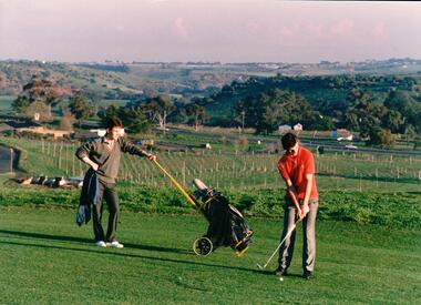
... The golf club was part of the Goonawarra Housing Estate which was developed on the area previously known as Goonawarra Farm. ...The golf club was part of the Goonawarra Housing Estate which was developed on the area previously known as Goonawarra Farm. ...The series of photographs were taken shortly after the opening of the newly established Goona Warra Golf Club in the early 1980s. The golf club was part of the Goonawarra Housing Estate which was developed on the area previously known as Goonawarra Farm. The new golf club replaced 'The Pines' which was part of the Caloola complex.A coloured photograph of two golfers. One is preparing to hit off while the other is standing in the background with the golf buggy. They are standing overlooking the Goonawarra and Craiglea vineyards and the Jacksons Creek valley.goona warra golf club, george evans collection -
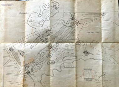 Phillip Island and District Historical Society Inc.
Map, Map of Summerland Golf Course, 15/12/1927
... It consisted of a housing estate, guest house and golf course. This area was acquired and all buildings, roads etc removed by the Victorian Government in the 1980s for a nature reserve for the penguins. ...It consisted of a housing estate, guest house and golf course. This area was acquired and all buildings, roads etc removed by the Victorian Government in the 1980s for a nature reserve for the penguins. ...Summerland Estate was created in the 1920s by A.K. T. Sampbell. It consisted of a housing estate, guest house and golf course. This area was acquired and all buildings, roads etc removed by the Victorian Government in the 1980s for a nature reserve for the penguins. This is believed to be the only time in the world when humans have been removed to benefit nature. HistoricalPurple leather covered fold out linen map with hand drawn diagram of the topography, layout of golf holes and club house Broken sand dunes, rough sandy hills, grassy hills and mounds, Swan Lake, Par for nine holes 34, Scratch score for nine holes 36, Drawn by A. Russell 12/12/1927summerland estate, a.k. t. sampbell, map, penguin reserve, summerland golf course -
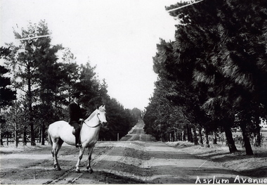 Sunbury Family History and Heritage Society Inc.
Photograph, c1900s
... In later years the conifer trees were replaced with oak trees and today The Avenue is still the main road leading into Jacksons Hill, the housing estate that has been built on the former Sunbury Asylum land....In later years the conifer trees were replaced with oak trees and today The Avenue is still the main road leading into Jacksons Hill, the housing estate that has been built on the former Sunbury Asylum land. ...The man on the horse was photographed close to the main entrance of The Avenue which was the main approach to the former Sunbury Asylum. In later years the conifer trees were replaced with oak trees and today The Avenue is still the main road leading into Jacksons Hill, the housing estate that has been built on the former Sunbury Asylum land.The housing development on the former Sunbury Asylum site began in the 1980s. A non-digital black and white photograph of a man astride a white horse standing on an unmade road with an avenue of tall trees growing on either side of the formed road. A building is just visible in the distance.the avenue, sunbury as, jacksons hill -
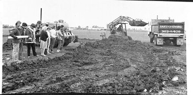 Broadmeadows Historical Society & Museum
Photograph, Construction of Access Road, Banksia Gardens, c 1980s
... The construction of the access road was a crucial step in the urban planning process, facilitating easier movement for residents and contributing to the overall development and integration of the housing estate....The construction of the access road was a crucial step in the urban planning process, facilitating easier movement for residents and contributing to the overall development and integration of the housing estate. This item, showing the construction of the Access Road to Banksia Gardens, holds significant historical value. ...This item depicts the construction of the Access Road to Banksia Gardens, The photograph captures a significant moment in the development of the Banksia Gardens housing project, highlighting the infrastructure improvements aimed at enhancing accessibility and connectivity within the community. The construction of the access road was a crucial step in the urban planning process, facilitating easier movement for residents and contributing to the overall development and integration of the housing estate.This item, showing the construction of the Access Road to Banksia Gardens, holds significant historical value. It documents a pivotal moment in the development of the Banksia Gardens housing project, illustrating the efforts to improve infrastructure and accessibility within the community. The construction of the access road was a key component in the urban planning strategy, aimed at enhancing connectivity and facilitating the movement of residents. This development not only improved the practical aspects of daily life for the community but also symbolised progress and growth within the housing estate. The photograph serves as an important record of the planning and development processes that shaped the Banksia Gardens community.Poor quality black and white photograph on matte photographic paper.banksia gardens, broadmeadows, construction, access road, c 1980's -
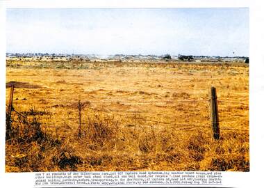 Sunshine and District Historical Society Incorporated
Photograph - Remnants of Don Gilbertsons holding, Johnson Des, 2001
... Photocopy Photograph by Des Johnson 9 March 2002 Remnants of Don Gilbertsons animal holding paddock Lot 607 Taylors Road Sydenham Looking south over Kororoit Creek to a new housing estate now Caroline Springs and to Ballarat Road Deer Park Melway map 356 H-7-10 and 358 G-4 High water tank steel stand all bull dozed for recycling (had produce grain crops and animal holding paddocks before transporting to the abattoirs looking south to big gum trees...Gilbertsons Taylors Road Sydenham Photocopy Photograph by Des Johnson 9 March 2002 Remnants of Don Gilbertsons animal holding paddock Lot 607 Taylors Road Sydenham Looking south over Kororoit Creek to a new housing estate now Caroline Springs and to Ballarat Road Deer Park Melway map 356 H-7-10 and 358 G-4 High water tank steel stand all bull dozed for recycling (had produce grain crops and animal holding paddocks before transporting to the abattoirs looking south to big gum trees Remnants of Don Gilbertsons holding Photograph Remnants of Don Gilbertsons holding Johnson Des ...Photocopy Photograph by Des Johnson 9 March 2002 Remnants of Don Gilbertsons animal holding paddock Lot 607 Taylors Road Sydenham Looking south over Kororoit Creek to a new housing estate now Caroline Springs and to Ballarat Road Deer Park Melway map 356 H-7-10 and 358 G-4 High water tank steel stand all bull dozed for recycling (had produce grain crops and animal holding paddocks before transporting to the abattoirs looking south to big gum treesgilbertsons, taylors road, sydenham -
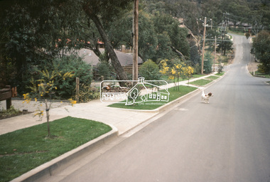
 Eltham District Historical Society Inc
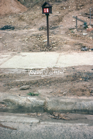
Photograph, Kerb and channeling works, Beard Street and Main Road, Eltham, 3 Sep 1981
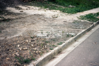
... These images provide a perspective of housing estate developments and changes in housing styles and road development which began sweeping in from the mid 1970s with increasing urbanisation of what was once more outlying suburbs and regions....These images provide a perspective of housing estate developments and changes in housing styles and road development which began sweeping in from the mid 1970s with increasing urbanisation of what was once more outlying suburbs and regions. ...Roll of film taken by Eltham Shire Council officers of roads and houses in the Eltham East area, 3 September 1981 prior to construction of new water main; including views of existing damage to footpaths and gutters and general views of Beard Street. These images provide a perspective of housing estate developments and changes in housing styles and road development which began sweeping in from the mid 1970s with increasing urbanisation of what was once more outlying suburbs and regions.35mm colour positive transparency (1 of 28) Mount - Kodak Kodachrome Cardbeard street, eltham, footpaths and gutters, infrastructure, roads, main road -
 Eltham District Historical Society Inc
Photograph, Beard Street, Eltham, 3 Sep 1981
... These images provide a perspective of housing estate developments and changes in housing styles and road development which began sweeping in from the mid 1970s with increasing urbanisation of what was once more outlying suburbs and regions....These images provide a perspective of housing estate developments and changes in housing styles and road development which began sweeping in from the mid 1970s with increasing urbanisation of what was once more outlying suburbs and regions. beard street eltham infrastructure roads Horse Park Road 35mm colour positive transparency (1 of 28) Mount - Kodak Kodachrome Card Beard Street, Eltham Photograph Photograph ...Roll of film taken by Eltham Shire Council officers of roads and houses in the Eltham East area, 3 September 1981 prior to construction of new water main; including views of existing damage to footpaths and gutters and general views of Beard Street. These images provide a perspective of housing estate developments and changes in housing styles and road development which began sweeping in from the mid 1970s with increasing urbanisation of what was once more outlying suburbs and regions.35mm colour positive transparency (1 of 28) Mount - Kodak Kodachrome Cardbeard street, eltham, infrastructure, roads, horse, park road -
 Eltham District Historical Society Inc
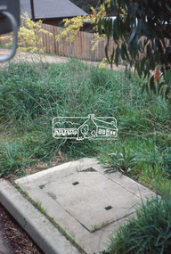
Photograph, Foothpath and kerb damage, Bainbridge Drive, Eltham, 3 Sep 1981
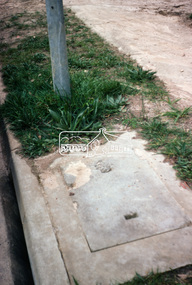
... These images provide a perspective of housing estate developments and changes in housing styles and road development which began sweeping in from the mid 1970s with increasing urbanisation of what was once more outlying suburbs and regions....These images provide a perspective of housing estate developments and changes in housing styles and road development which began sweeping in from the mid 1970s with increasing urbanisation of what was once more outlying suburbs and regions. eltham infrastructure roads Bainbridge Drive Footpaths and gutters 35mm colour positive transparency (1 of 28) Mount - Kodak Kodachrome Card Foothpath and kerb damage, Bainbridge Drive, Eltham Photograph Photograph ...Roll of film taken by Eltham Shire Council officers of roads and houses in the Eltham East area, 3 September 1981 prior to construction of new water main; including views of existing damage to footpaths and gutters and general views of Beard Street. These images provide a perspective of housing estate developments and changes in housing styles and road development which began sweeping in from the mid 1970s with increasing urbanisation of what was once more outlying suburbs and regions.35mm colour positive transparency (1 of 28) Mount - Kodak Kodachrome Cardeltham, infrastructure, roads, bainbridge drive, footpaths and gutters -
 Eltham District Historical Society Inc
Photograph, Foothpath and kerb damage, Bainbridge Drive, Eltham, 3 Sep 1981
... These images provide a perspective of housing estate developments and changes in housing styles and road development which began sweeping in from the mid 1970s with increasing urbanisation of what was once more outlying suburbs and regions....These images provide a perspective of housing estate developments and changes in housing styles and road development which began sweeping in from the mid 1970s with increasing urbanisation of what was once more outlying suburbs and regions. eltham infrastructure roads bainbridge drive footpaths and gutters 35mm colour positive transparency (1 of 28) Mount - Kodak Kodachrome Card Foothpath and kerb damage, Bainbridge Drive, Eltham Photograph Photograph ...Roll of film taken by Eltham Shire Council officers of roads and houses in the Eltham East area, 3 September 1981 prior to construction of new water main; including views of existing damage to footpaths and gutters and general views of Beard Street. These images provide a perspective of housing estate developments and changes in housing styles and road development which began sweeping in from the mid 1970s with increasing urbanisation of what was once more outlying suburbs and regions.35mm colour positive transparency (1 of 28) Mount - Kodak Kodachrome Cardeltham, infrastructure, roads, bainbridge drive, footpaths and gutters -
 Eltham District Historical Society Inc
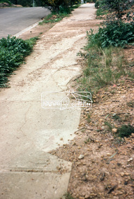
Photograph, Foothpath and kerb damage, Madine Way, Eltham, 3 Sep 1981
... These images provide a perspective of housing estate developments and changes in housing styles and road development which began sweeping in from the mid 1970s with increasing urbanisation of what was once more outlying suburbs and regions....These images provide a perspective of housing estate developments and changes in housing styles and road development which began sweeping in from the mid 1970s with increasing urbanisation of what was once more outlying suburbs and regions. eltham infrastructure roads footpaths and gutters Madine Way 35mm colour positive transparency (1 of 28) Mount - Kodak Kodachrome Card Foothpath and kerb damage, Madine Way, Eltham Photograph Photograph ...Roll of film taken by Eltham Shire Council officers of roads and houses in the Eltham East area, 3 September 1981 prior to construction of new water main; including views of existing damage to footpaths and gutters and general views of Beard Street. These images provide a perspective of housing estate developments and changes in housing styles and road development which began sweeping in from the mid 1970s with increasing urbanisation of what was once more outlying suburbs and regions.35mm colour positive transparency (1 of 28) Mount - Kodak Kodachrome Cardeltham, infrastructure, roads, footpaths and gutters, madine way -
 Eltham District Historical Society Inc
Photograph, Foothpath and kerb damage, Madine Way, Eltham, 3 Sep 1981
... These images provide a perspective of housing estate developments and changes in housing styles and road development which began sweeping in from the mid 1970s with increasing urbanisation of what was once more outlying suburbs and regions....These images provide a perspective of housing estate developments and changes in housing styles and road development which began sweeping in from the mid 1970s with increasing urbanisation of what was once more outlying suburbs and regions. eltham infrastructure roads footpaths and gutters madine way 35mm colour positive transparency (1 of 28) Mount - Kodak Kodachrome Card Foothpath and kerb damage, Madine Way, Eltham Photograph Photograph ...Roll of film taken by Eltham Shire Council officers of roads and houses in the Eltham East area, 3 September 1981 prior to construction of new water main; including views of existing damage to footpaths and gutters and general views of Beard Street. These images provide a perspective of housing estate developments and changes in housing styles and road development which began sweeping in from the mid 1970s with increasing urbanisation of what was once more outlying suburbs and regions.35mm colour positive transparency (1 of 28) Mount - Kodak Kodachrome Cardeltham, infrastructure, roads, footpaths and gutters, madine way -
 Eltham District Historical Society Inc
Photograph, Madine Way, Eltham, 3 Sep 1981
... These images provide a perspective of housing estate developments and changes in housing styles and road development which began sweeping in from the mid 1970s with increasing urbanisation of what was once more outlying suburbs and regions....These images provide a perspective of housing estate developments and changes in housing styles and road development which began sweeping in from the mid 1970s with increasing urbanisation of what was once more outlying suburbs and regions. eltham infrastructure roads madine way Tadema Park 35mm colour positive transparency (1 of 28) Mount - Kodak Kodachrome Card Madine Way, Eltham Photograph Photograph ...Roll of film taken by Eltham Shire Council officers of roads and houses in the Eltham East area, 3 September 1981 prior to construction of new water main; including views of existing damage to footpaths and gutters and general views of Beard Street. These images provide a perspective of housing estate developments and changes in housing styles and road development which began sweeping in from the mid 1970s with increasing urbanisation of what was once more outlying suburbs and regions.35mm colour positive transparency (1 of 28) Mount - Kodak Kodachrome Cardeltham, infrastructure, roads, madine way, tadema park -
 Eltham District Historical Society Inc
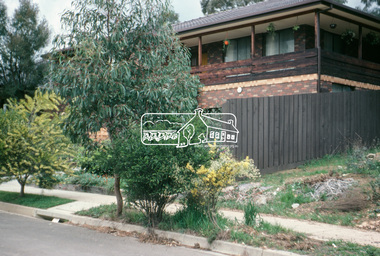
Photograph, Beard Street, Eltham, 3 Sep 1981
... These images provide a perspective of housing estate developments and changes in housing styles and road development which began sweeping in from the mid 1970s with increasing urbanisation of what was once more outlying suburbs and regions....These images provide a perspective of housing estate developments and changes in housing styles and road development which began sweeping in from the mid 1970s with increasing urbanisation of what was once more outlying suburbs and regions. eltham infrastructure roads Beard Street frank street Shalbury Avenue 35mm colour positive transparency (1 of 28) Mount - Kodak Kodachrome Card Beard Street, Eltham Photograph Photograph ...Roll of film taken by Eltham Shire Council officers of roads and houses in the Eltham East area, 3 September 1981 prior to construction of new water main; including views of existing damage to footpaths and gutters and general views of Beard Street. These images provide a perspective of housing estate developments and changes in housing styles and road development which began sweeping in from the mid 1970s with increasing urbanisation of what was once more outlying suburbs and regions.35mm colour positive transparency (1 of 28) Mount - Kodak Kodachrome Cardeltham, infrastructure, roads, beard street, frank street, shalbury avenue -
 Eltham District Historical Society Inc
Photograph, Beard Street, Eltham, 3 Sep 1981
... These images provide a perspective of housing estate developments and changes in housing styles and road development which began sweeping in from the mid 1970s with increasing urbanisation of what was once more outlying suburbs and regions....These images provide a perspective of housing estate developments and changes in housing styles and road development which began sweeping in from the mid 1970s with increasing urbanisation of what was once more outlying suburbs and regions. eltham infrastructure roads beard street 35mm colour positive transparency (1 of 28) Mount - Kodak Kodachrome Card Beard Street, Eltham Photograph Photograph ...Roll of film taken by Eltham Shire Council officers of roads and houses in the Eltham East area, 3 September 1981 prior to construction of new water main; including views of existing damage to footpaths and gutters and general views of Beard Street. These images provide a perspective of housing estate developments and changes in housing styles and road development which began sweeping in from the mid 1970s with increasing urbanisation of what was once more outlying suburbs and regions.35mm colour positive transparency (1 of 28) Mount - Kodak Kodachrome Cardeltham, infrastructure, roads, beard street -
 Eltham District Historical Society Inc
Photograph, Beard Street, Eltham, 3 Sep 1981
... These images provide a perspective of housing estate developments and changes in housing styles and road development which began sweeping in from the mid 1970s with increasing urbanisation of what was once more outlying suburbs and regions....These images provide a perspective of housing estate developments and changes in housing styles and road development which began sweeping in from the mid 1970s with increasing urbanisation of what was once more outlying suburbs and regions. eltham infrastructure roads beard street Frank Street 35mm colour positive transparency (1 of 28) Mount - Kodak Kodachrome Card Beard Street, Eltham Photograph Photograph ...Roll of film taken by Eltham Shire Council officers of roads and houses in the Eltham East area, 3 September 1981 prior to construction of new water main; including views of existing damage to footpaths and gutters and general views of Beard Street. These images provide a perspective of housing estate developments and changes in housing styles and road development which began sweeping in from the mid 1970s with increasing urbanisation of what was once more outlying suburbs and regions.35mm colour positive transparency (1 of 28) Mount - Kodak Kodachrome Cardeltham, infrastructure, roads, beard street, frank street -
 Eltham District Historical Society Inc
Photograph, Beard Street, Eltham, 3 Sep 1981
... These images provide a perspective of housing estate developments and changes in housing styles and road development which began sweeping in from the mid 1970s with increasing urbanisation of what was once more outlying suburbs and regions....These images provide a perspective of housing estate developments and changes in housing styles and road development which began sweeping in from the mid 1970s with increasing urbanisation of what was once more outlying suburbs and regions. eltham infrastructure roads beard street frank street 35mm colour positive transparency (1 of 28) Mount - Kodak Kodachrome Card Beard Street, Eltham Photograph Photograph ...Roll of film taken by Eltham Shire Council officers of roads and houses in the Eltham East area, 3 September 1981 prior to construction of new water main; including views of existing damage to footpaths and gutters and general views of Beard Street. These images provide a perspective of housing estate developments and changes in housing styles and road development which began sweeping in from the mid 1970s with increasing urbanisation of what was once more outlying suburbs and regions.35mm colour positive transparency (1 of 28) Mount - Kodak Kodachrome Cardeltham, infrastructure, roads, beard street, frank street -
 Eltham District Historical Society Inc
Photograph, Beard Street, Eltham, 3 Sep 1981
... These images provide a perspective of housing estate developments and changes in housing styles and road development which began sweeping in from the mid 1970s with increasing urbanisation of what was once more outlying suburbs and regions....These images provide a perspective of housing estate developments and changes in housing styles and road development which began sweeping in from the mid 1970s with increasing urbanisation of what was once more outlying suburbs and regions. eltham infrastructure roads beard street grove street valonia drive wycliffe crescent Livingstone Road 35mm colour positive transparency (1 of 28) Mount - Kodak Kodachrome Card Beard Street, Eltham Photograph Photograph ...Roll of film taken by Eltham Shire Council officers of roads and houses in the Eltham East area, 3 September 1981 prior to construction of new water main; including views of existing damage to footpaths and gutters and general views of Beard Street. These images provide a perspective of housing estate developments and changes in housing styles and road development which began sweeping in from the mid 1970s with increasing urbanisation of what was once more outlying suburbs and regions.35mm colour positive transparency (1 of 28) Mount - Kodak Kodachrome Cardeltham, infrastructure, roads, beard street, grove street, valonia drive, wycliffe crescent, livingstone road