Showing 1772 items
matching maps and plans
-
 Bendigo Historical Society Inc.
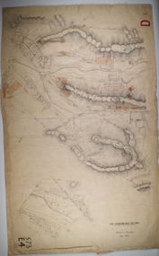
Map - BOROUGH OF EAGLEHAWK SHEET 3, Circa 1880's
Map: Borough of Eaglehawk , sheet No. 3. Parish planmap, bendigo, parish plan, `borough of eaglhawk -
 Bendigo Historical Society Inc.
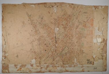
Map - SANDHURST SHEETS 1 AND 2, No date visible
Map: Sandhurst sheets 1 and 2. Parish planmap, bendigo, parish plan, sandhurst -
 Bendigo Historical Society Inc.
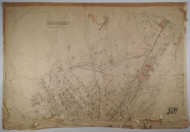
Map - SANDHURST, No date Visible
Map: Parish plan showing the Northern section of the Municipalitymap, bendigo, parish plan, sandhurst -
 Bendigo Historical Society Inc.
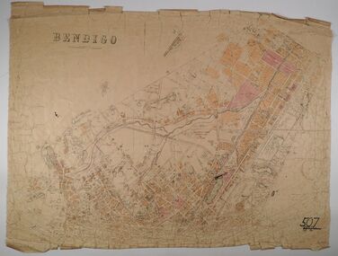
Map - BENDIGO, No date visible
Map: Parish plan showing the Northern section of the Municipalitymap, bendigo, parish plan, bendigo -
 Bendigo Historical Society Inc.
Map - JACK FLYNN COLLECTION: GIRGARRE, 14/10/1943
Map: Parish of Girgarre , County of Rodney. Parish plan. Same map as 10100.20 but in poorer condition.By Authority, H.E.Daw, Government printer Melbourne. Drawn and Reproduced at the Dept, of Lands and Survey, Melbourne, Victoriamap, rodney, girgarre, girgarre, county of rodney -
 Bendigo Historical Society Inc.
Map - CITY OF BENDIGO SHEET 2, No date visible
Map: City of Bendigo Sheet 2, Town plan ( number 143 in Map Cupboard 1)map, city of bendigo sheet 2, city streets -
Bendigo Historical Society Inc.
Map - SALISBURY WEST, 14/10/1943
Map: Salisbury West, County of Gladstone. Parish plan ( number 179 in Map Cupboard 1)map, gladstone, parish plan, salisbury west , county of gladstone -
Bendigo Historical Society Inc.
Map - PARISH OF LAANECOORIE, 13/10/1930
Map: Parish of Laanecoorie, County of Bendigo. Parish plan ( number 176 in Map Cupboard 1)map, bendigo, parish plan, laanecoorie -
Bendigo Historical Society Inc.
Map - LANGWORNOR, 17/07/1942
Map: Langwornor, County of Dalhousie. Parish Plan, coloured ( number 165 in Map Cupboard 1)map, dalhousie, parish plan, langwornor, county of dalhousie -
Bendigo Historical Society Inc.
Map - COSTERFIELD, 2/09/1939
Map: Costerfield, Counties of Dalhousie and Rodney. Parish plan ( number 163 in Map Cupboard 1)map, dalhousie, parish plan, costerfield, counties of dalhousie and rodney -
Bendigo Historical Society Inc.
Map - BOROUGH OF EAGLEHAWK SHEET 1A, 30/11/1931
Map: Borough of Eaglehawk, Parish of Nerring. Parish plan ( number 186 in Map Cupboard 1)map, bendigo, parish plan, borough of eaglehawk, parish of nerring -
Bendigo Historical Society Inc.
Map - HARCOURT, 2/04/1917
Map: Town of Harcourt, County of Talbot. Parish plan (number 264 in map cupboard 1)map, talbot, township, harcourt -
Bendigo Historical Society Inc.
Map - TOWNSHIP OF HEATHCOTE SHEET 2, Circa 1935
Map: Township of Heathcote sheet 2. Parish plan (number 254 in map cupboard 1)map, dalhousie, township, heathcote -
Bendigo Historical Society Inc.
Map - PARISH OF DIGGORRA, 23/02/1911
Map: Parish of Diggorra, County of Bendigo. Parish plan ( number 247 in Map Cupboard 1)map, bendigo, parish plan, diggorra -
Bendigo Historical Society Inc.
Map - TARNAGULLA, Examined May 1883
Map: Tarnagulla, Counties of Gladstone and bendigo. Parish plan ( number 244 in Map Cupboard 1)map, gladstone, parish plan, tarnagulla, gladstone -
Bendigo Historical Society Inc.
Map - EPPALOCK RESURVEY, Circa 1880
Map: Eppalock resurvey, hand draughted parish plan ( number 239 in Map Cupboard 1)map, bendigo, parish plan, eppalock -
Bendigo Historical Society Inc.
Map - CITY OF SANDHURST SHEET NO 4, 25/04/1882
Map: City of sandhurst sheet No. 4. Parish plan ( number 224 in Map Cupboard 1)map, bendigo, parish plan, sandhusrt -
Bendigo Historical Society Inc.
Map - CITY OF SANDHURST SHEET NO. 5, 18/04/1882
Map: City of sandhurst sheet No. 5. Parish plan ( number 223 in Map Cupboard 1)map, bendigo, parish plan, sandhusrt -
Bendigo Historical Society Inc.
Map - CITY OF BENDIGO SHEET NO. 4, Circa 1900
Map: City of Bendigo sheet No. 4. Parish plan ( number 218 in Map Cupboard 1)map, bendigo, parish plan, bendigo -
Bendigo Historical Society Inc.
Map - CITY OF BENDIGO SHEET NO. 2, Circa 1900
Map: City of Bendigo sheet No. 2 . Parish plan ( number 217 in Map Cupboard 1)map, bendigo, parish plan, bendigo -
Bendigo Historical Society Inc.
Map - CITY OF BENDIGO SHEET NO. 6, surveyed 3/03/1882
Map: City of Bendigo sheet No. 6 . Parish plan ( number 215 in Map Cupboard 1)map, bendigo, parish plan, bendigo -
Bendigo Historical Society Inc.
Map - CITY OF BENDIGO SHEET NO. 5, Circa 1890's
Map: City of Bendigo sheet No. 5. Parish plan ( number 213 in Map Cupboard 1)map, bendigo, parish plan, bendigo -
Bendigo Historical Society Inc.
Map - SALISBURY WEST, 29/01/1878
Map: Salisbury West, County of Gladstone. Parish plan (number 305 in map cupboard 1)map, gladstone, parish plan, salisbury west -
Bendigo Historical Society Inc.
Map - JANIEMBER EAST, No date visible
Map: Janiember East, Hand Draughted? Parish plan (number 299 in map cupboard 1)map, bendigo, parish plan, janiember east , serpentine -
Bendigo Historical Society Inc.
Map - AXEDALE, 10/10/1904
Map: Axedale, Counties of Bendigo and Rodney. Parish plan (number 297 in map cupboard 1)map, bendigo, parish plan, axedale -
Bendigo Historical Society Inc.
Map - MANDURANG 2, March 194-?
Map: Mandurang 2, County of Bendigo. Parish plan (number 296 in map cupboard 1)map, bendigo, parish plan, mandurang -
Bendigo Historical Society Inc.
Map - MANDURANG 1, March 1947
Map: Mandurang 1, County of Bendigo. Parish plan (number 295 in map cupboard 1)map, bendigo, parish plan, mandurang -
Bendigo Historical Society Inc.
Map - HUNTLY ALLOTMENTS, No date visible
Map; Huntly Allotments, County of Bendigo. Parish plan (number 289 in map cupboard 1)map, bendigo, allotments, huntly allotments -
Bendigo Historical Society Inc.
Map - PARISH OF WHIRRAKEE, Surveyed 14/07/1904
Map: Parish of Whirrakee. Hand Draughted Parish plan (number 280 in map cupboard 1)map, bendigo, parish plan, whirrakee -
Bendigo Historical Society Inc.
Map - ROCHESTER WEST, 22/12/1881
Map: Rochester West, County of Bendigo. Parish plan (number 279 in map cupboard 1)map, bendigo, parish plan, rochester west