Showing 217 items
matching panoramic views
-
 Kew Historical Society Inc
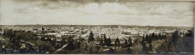
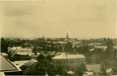
Photograph, J F C Farquhar, Bird's Eye View Looking West, 1891
... to be the roof of Xavier College, from which the panoramic view extends... Eye View Looking West Before true aerial photography became ...At the beginning of the 1890s, the Kew businessman and Town Councillor, Henry Kellett, commissioned J.F.C. Farquhar to photograph scenes of Kew. These scenes included panoramas as well as pastoral scenes. The resulting set of twelve photographs was assembled in an album, Kew Where We Live, from which customers could select images for purchase.The preamble to the album describes that the photographs used the ‘argentic bromide’ process, now more commonly known as the gelatine silver process. This form of dry plate photography allowed for the negatives to be kept for weeks before processing, hence its value in landscape photography. The resulting images were considered to be finely grained and everlasting. Evidence of the success of Henry Kellett’s venture can be seen today, in that some of the photographs are held in national collections.It is believed that the Kew Historical Society’s copy of the Kellett album is unique and that the photographs in the book were the first copies taken from the original plates. It is the first and most important series of images produced about Kew. The individual images have proved essential in identifying buildings and places of heritage value in the district.Before true aerial photography became possible, photographers such as J.F.C. Farquhar were compelled to shoot their images from the highest vantage point. Here, it is presumed to be the roof of Xavier College, from which the panoramic view extends west towards the rise of Studley Park. The houses in the foreground face the southern end of Gellibrand Street. Wellington Street is at an angle to the camera with the Queen Street intersection on the near right. The wooden building behind the large horse paddock on the other side of Gellibrand Street is the Kew Recreation Hall, built 1888, demolished 1960. It was reputed to have one of the finest dancing floors in or around Melbourne. The Bowling Green at the rear of the Hall belonged to the Kew Bowling Club. Further west is the Kew Railway Station on Denmark Street, opened to the public in 1887. At this period, much of Studley Park was locked up in large landholdings, dominated by large mansions such as ‘Byram’. Bird's Eye View Looking Westkew illustrated, kew where we live, photographic books, henry kellett, denmark street, kew recreation hall, kew bowling club, wellington street -
 Bendigo Historical Society Inc.
Photograph - BENDIGO FROM CAMP HILL FIRE TOWER, c.1905
... . Narrow panoramic view of 'Bendigo from Camp Hill Fire Tower... board. Narrow panoramic view of 'Bendigo from Camp Hill Fire ...BHS CollectionBlack and white/sepia? Photograph mounted on green board. Narrow panoramic view of 'Bendigo from Camp Hill Fire Tower'. Rosalind Park in foreground., School of Mines, Town Hall, Bendigo Arcade, Banks, The Beehive, City Family Hotel, Law Courts and Post Office in foreground. Shamrock Hotel to left. Poppet legs of Royal Hustler's Mine Pall Mall. Inscriptions: 'Copyright Melb. P Scott', 'Bendigo from Camp Hill Fire Tower'. Royal Historical society of Victoria, Bendigo Branch, Circular blue stamp on back. 'MP270' TR corner. Portion of oval stamp on bottom right. Hand printed across bottom in ballpoint pen 'property of HJG Biggs, Town Hall Eaglehawk'. Portion of oval rubber stamp, purple, 'T. CA.., FOO.. Mark.. Be..' History: Previous Acc. No. MP 270.P Scottplace, landscape view, bendigo, bendigo, rosalind park, school of mines, bendigo town hall, camp hill, landscape, post office, bendigo post office, shamrock hotel, pall mall, fire tower -
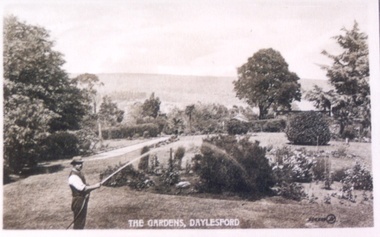
 Port Fairy Historical Society Museum and Archives
Photograph, A.C. Aberline, The Gardens, Port Fairy
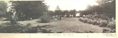
... Gardens, Port Fairy - flowers & lawns panoramic view... & lawns panoramic view. The Port Fairy Botanical Gardens were ...Gardens, Port Fairy - flowers & lawns panoramic view. The Port Fairy Botanical Gardens were formed in 1856 making it one of the earliest gardens in Victoria. The first curator was James Prior, he was paid fifty-two pounds per annum. He was an outstanding curator having been apprenticed to the trade in England at the age of 12, his brother Edward in later years was the Curator of the Koroit Gardens. Prior retired in 1903. During the years of his curatorship Port Fairy was said to have the best gardens outside the city of Melbourne, he was constantly in touch with Baron Von Mueller and later Guilfoyle of the Royal Botanical Gardens of Melbourne. In the early years plants from all over the world were planted here with varying rates of success many of them sent by Baron Von Mueller. In the 1930’ and 40’s the gardens were still very beautiful, and the curator was Roy Manuell. The beautiful iron gates at the entrance were destroyed in the 1946 floods and were replaced in 1989 using some of the material from the original gates. From the 1950’s on the gardens went into a state of decline, much being taken up by the caravan park until in 1986, after a public meeting ‘Friends of the Gardens’ was founded when the entrance section was restored. Black and white Photograph of Port Fairy Gardens glued to cardboard as a mountThe Gardens Port Fairy—- A.C.Aberline, 26 Faversham Road, Canterbury gardens, botanical -
 Port Fairy Historical Society Museum and Archives
Photograph, A.C. Aberline, Gardens, Port Fairy
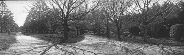
... Gardens, Port Fairy panoramic view. The Port Fairy... Street Port Fairy great-ocean-road Gardens, Port Fairy panoramic ...Gardens, Port Fairy panoramic view. The Port Fairy Botanical Gardens were formed in 1856 making it one of the earliest gardens in Victoria. The first curator was James Prior, he was paid fifty-two pounds per annum. He was an outstanding curator having been apprenticed to the trade in England at the age of 12, his brother Edward in later years was the Curator of the Koroit Gardens. Prior retired in 1903. During the years of his curatorship Port Fairy was said to have the best gardens outside the city of Melbourne, he was constantly in touch with Baron Von Mueller and later Guilfoyle of the Royal Botanical Gardens of Melbourne. In the early years plants from all over the world were planted here with varying rates of success many of them sent by Baron Von Mueller. In the 1930’ and 40’s the gardens were still very beautiful, and the curator was Roy Manuell. The beautiful iron gates at the entrance were destroyed in the 1946 floods and were replaced in 1989 using some of the material from the original gates. From the 1950’s on the gardens went into a state of decline, much being taken up by the caravan park until in 1986, after a public meeting ‘Friends of the Gardens’ was founded when the entrance section was restored. Black and white panoramic photograph of the bare limbed trees in the botanical gardensGardens, Port Fairy- A.C.Aberline, 26 Faversham Road, Canterburygardens, winter, trees, botanical -
 The Beechworth Burke Museum
Photograph, 1934
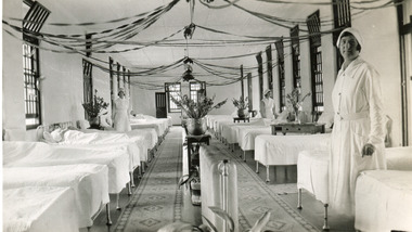
... Melbourne. The site was chosen for its panoramic view... Melbourne. The site was chosen for its panoramic view ...The photo is taken in 1934 and illustrates the internal view of a ward in the Mental Hospital at Beechworth. Some patients in beds and three nurses are in view. Beds were arranged in lines alongside the walls and there were no partitions or screens to create privacy for patients. Furniture was simple and humble; bed frames were made of metal or wood and pillowcases and covers for the attendant`s tables were sometimes made of blue-striped canvas or calico. Large windows in the walls were offering ample light and the room was well-tended, with Christmas decoration, flowers, pots and carpets on the floor. The nurse in the foreground is Miss Neary. The Mayday Hills Hospital was constructed between 1864 and 1867, with buildings created in a number of periods. It formally opened on 24 October 1867 and, along with the Ovens Hospital and the Benevolent Asylum, made Beechworth a prominent social welfare centre in Victoria. The need for an institution of this kind was arisen due to the increased number of people with mental disturbances (induced by the harsh living conditions on the goldfields) and the remoteness of the district from Melbourne. The site was chosen for its panoramic view of the countryside, the hilltop atmosphere and the native fauna, all contributing to the cure of patients. The Hospital was originally named the “Ovens Lunatic Asylum” but, during the centenary celebrations in 1967, the name was officially changed to “Mayday Hills Hospital”, showing the gradual shift in the perception and understanding of mental health conditions over the last decades. The Hospital lies on the traditional land of the Kulin Nation. This photograph is historically significant as it provides an insight into the living conditions of patients admitted to the Mayday Hills Hospital at the beginning of the 20th century. It also contributes to the understanding of the district`s development and its importance to the course of Victoria`s history. Additionally, it provides important information about the way mental health conditions were perceived at that time and how patients were treated. Black and white rectangular photograph printed on paper. Reverse: 1997.2665/ To Miss JA.Peach/ [hallmark: Printed by Harringtons]/ With best wishes/from/H.Jeanes/for 1934.mayday hills hospital, benevolent asylum, ovens hospital, ovens lunatic asylum, kulin nation, beechworth, patients, nurse, social welfare, goldfields, melbourne, mental health, living conditions, blue-striped canvas, calico, bed frames, miss neary, mental disturbances, traditional land, centenary celebrations -
 Kew Historical Society Inc
Photograph, J F C Farquhar, Bird's Eye View Looking North, 1891
... This panoramic view was probably taken from the roof... Looking North This panoramic view was probably taken from the roof ...At the beginning of the 1890s, the Kew businessman and Town Councillor, Henry Kellett, commissioned J.F.C. Farquhar to photograph scenes of Kew. These scenes included panoramas as well as pastoral scenes. The resulting set of twelve photographs was assembled in an album, Kew Where We Live, from which customers could select images for purchase.The preamble to the album describes that the photographs used the ‘argentic bromide’ process, now more commonly known as the gelatine silver process. This form of dry plate photography allowed for the negatives to be kept for weeks before processing, hence its value in landscape photography. The resulting images were considered to be finely grained and everlasting. Evidence of the success of Henry Kellett’s venture can be seen today, in that some of the photographs are held in national collections.It is believed that the Kew Historical Society’s copy of the Kellett album is unique and that the photographs in the book were the first copies taken from the original plates. It is the first and most important series of images produced about Kew. The individual images have proved essential in identifying buildings and places of heritage value in the district.This panoramic view was probably taken from the roof of Xavier College. It invites the viewer to look down on the buildings and streets of Kew, and across to the distant horizon. Mansions and solid bourgeois villas dominate the view of Charles and Wellington Streets. The imposing spires of the Presbyterian and Methodist Churches, built in one of the highest areas of Kew, can be seen in the distance. In the foreground, the photographer includes three significant mansions: Molina, Roxeth and Elsinore. Molina, in the foreground, and the group of weatherboard buildings in its yard was used at this stage for the privately operated ‘Kew High School’ (founded 1872). Roxeth, the home of Herbert Henty can be identified by its distinctive four-sided tower. All three buildings are now part of Trinity Grammar. Other built structures observable in the photograph include Wilton (now the Kew RSL), designed by Guyon Purchas for Dr William Walsh in 1886, and the only known image of the Prospect Hill Hotel prior to the renovation of 1935. Bird's Eye View Looking Northkew illustrated, kew where we live, photographic books, henry kellett -
 Kew Historical Society Inc
Plan - Subdivision Plan, J R Mathers & McMillan, Willsmere Park Estate, c.1940
... was claimed to be ‘high and dry’, and with panoramic views of Kew... was claimed to be ‘high and dry’, and with panoramic views of Kew ...Pru Sanderson, in her groundbreaking ‘City of Kew Urban Conservation Study : Volume 2 - Development History’ (1988), summarised the periods of urban development and subdivisions of land in Kew. The periods that she identified included 1845-1880, 1880-1893, 1893-1921, 1921-1933, 1933-1943, and Post-War Development. These periods were selected as they represented periods of rapid growth or decline in urban development. An obvious starting point for Sanderson’s groupings involved population growth and the associated economic cycles. These cycles also highlighted urban expansion onto land that was predominantly rural, although in other cases it represented the decline and breakup of large estates. A number of the plans in the Kew Historical Society’s collection can also be found in other collections, such as those of the State Library of Victoria and the Boroondara Library Service. A number are however unique to the collection.The Kew Historical Society collection includes almost 100 subdivision plans pertaining to suburbs of the City of Melbourne. Most of these are of Kew, Kew East or Studley Park, although a smaller number are plans of Camberwell, Deepdene, Balwyn and Hawthorn. It is believed that the majority of the plans were gifted to the Society by persons connected with the real estate firm - J. R. Mathers and McMillan, 136 Cotham Road, Kew. The Plans in the collection are rarely in pristine form, being working plans on which the agent would write notes and record lots sold and the prices of these. The subdivision plans are historically significant examples of the growth of urban Melbourne from the beginning of the 20th Century up until the 1980s. A number of the plans are double-sided and often include a photograph on the reverse. A number of the latter are by noted photographers such as J.E. Barnes. In 1910, the Willsmere Park Estate Dairy was lauded in the Box Hill Reporter as ‘an object lesson in dairying’. Ten years later, in 1923, it was to be sold. The first subdivision of the Estate included 77 grand allotments with frontages to Belford and Kilby Roads, Elm and Willow Groves, and Acacia Avenue. Every lot was claimed to be ‘high and dry’, and with panoramic views of Kew and East Kew. The balance of the Estate, and the largest proportion of allotments was to be subdivided and sold from 1940. This second sale included 109 lots fronting Kilby Road and Elm and Willow Groves. Annotations on the plan indicate that the more expensive lots faced Belford Road opposite the Kew Golf Links. Two of these sold for £310. Lots further to the west in Willow Grove were sold for £60 less. Many of the houses to be built on these 109 allotments after the War faced Government restrictions on building materials and the dimensions of each house due to postwar shortages.subdivision plans - east kew, willsmere park estate -
 The Beechworth Burke Museum
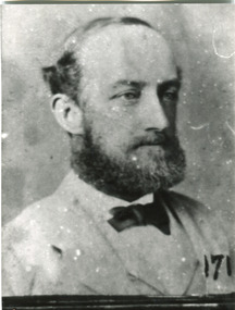
Photograph - Photograph Reproduction, 1870
... panoramic view... Melbourne. The site was chosen for its panoramic view... Melbourne. The site was chosen for its panoramic view ...The photograph is a copy of the original one, with the latter been captured in 1870. The man depicted is Doctor Thomas Thomson Dick, who was the first Medical Superintendent at Mayday Hills Hospital. He was born in Scotland in 1840 and he died in East Malvern in 1919. He obtained his degree of Doctor of Medicine from Melbourne University in 1864 and, later in his career, he became Inspector-General of the mentally ill. Dr Dick promoted the hospital`s self-sufficiency by engaging patients in various forms of work, such as clothing alterations and cultivation of the farm. He also introduced monthly balls, which could be attended by patients, staff and guests, and they were later replaced by concerts. The Mayday Hills Hospital was constructed between 1864 and 1867, with buildings created in a number of periods. It formally opened on 24 October 1867 and, along with the Ovens Hospital and the Benevolent Asylum, made Beechworth a prominent social welfare centre in Victoria. The need for an institution of this kind was arisen due to the increased number of people with mental disturbances (induced by the harsh living conditions on the goldfields) and the remoteness of the district from Melbourne. The site was chosen for its panoramic view of the countryside, the hilltop atmosphere and the native fauna, all contributing to the cure of patients.The Hospital was originally named the “Ovens Lunatic Asylum” but, during the centenary celebrations in 1967, the name was officially changed to “Mayday Hills Hospital”, showing the gradual shift in the perception and understanding of mental health conditions over the last decades. The Hospital lies on the traditional land of the Kulin Nation.This photograph is historically significant as it provides information about the staff served at the Mayday Hills Hospital when it first opened. It also contributes to the understanding of the district`s development and its importance to the course of Victoria`s history and adds valuable information about the changing approaches to the treatment of mental health conditions.Black and white rectangular photograph printed on paper.Obverse: (7)/ Reverse: 1997.2452/ Dr Dick/No(7) Pioneer Board/doctor thomas thomson dick, superintendent, mayday hills hospital, scotland, east malvern, doctor of medicine, melbourne university, inspector-general, clothing alterations, cultivation of the farm, self-sufficiency, balls, concerts, ovens hospital, benevolent asylum, beechworth, goldfields, kulin nation, panoramic view, mental health conditions -
 Eltham District Historical Society Inc
Photograph - Digital Photograph, Alan King, Garden Hill, Eltham-Yarra Glen Road, Kangaroo Ground, 3 February 2008
... the property in 1849 at the top of the hill with magnificent panoramic... the property in 1849 at the top of the hill with magnificent panoramic ...The original house was built around 1850 was one of Kangaroo Ground's earliest homes, part of which remains today. Built by Scottish farmer Andrew Harkness who acquired the property in 1849 at the top of the hill with magnificent panoramic views as far as Kinglake, the same year he married Sarah Oswin. The property was known as Garden Hill from at least 1865. Andrew and Sarah had four sons and five daughters. Harkness was a founder of the Kangaroo Ground School and one of the first to suggest establishing the Eltham District Road Board (1858-71) of which he was a member, the pre-cursor to the Shire of Eltham (1871-1994). He was also a Trustee of the Kangaroo Ground Cemetery. His daughter Fanny married farmer Alexander White who purchased the property in 1893. Alexander White died in 1906 and ownership transferred to Fanny White. Son, Robert White was a Councillor of the Shire of Eltham at the time the Shire acquired two acres of land on the adjacent property from the Mess brothers for the creation of the Shire of Eltham Memorial Park (1921) in which the Shire of Eltham War Memoirial tower was erected (1926). Fanny White donated a small section of land from the Garden Hill property to facilitate entry access to the park. The White family sold the property to Sir Herbert Gepp in 1925. Covered under Heritage Overlay, Nillumbik Planning Scheme. Published: Nillumbik Now and Then / Marguerite Marshall 2008; photographs Alan King with Marguerite Marshall.; p29This collection of almost 130 photos about places and people within the Shire of Nillumbik, an urban and rural municipality in Melbourne's north, contributes to an understanding of the history of the Shire. Published in 2008 immediately prior to the Black Saturday bushfires of February 7, 2009, it documents sites that were impacted, and in some cases destroyed by the fires. It includes photographs taken especially for the publication, creating a unique time capsule representing the Shire in the early 21st century. It remains the most recent comprehenesive publication devoted to the Shire's history connecting local residents to the past. nillumbik now and then (marshall-king) collection, kangaroo ground -
 Kiewa Valley Historical Society
Photographs –Collection of 10 copies and original black and white photographs and printed articles relating to skiing on the Bogong High Plains
... in and around Falls Creek/Mt Beauty 8. Panoramic view of ski fields... of holidaying in and around Falls Creek/Mt Beauty 8. Panoramic view ...After World War II, the Kiewa Hydro-Electric Scheme was started in the Kiewa River Valley by the State Electricity Commission of Victoria. On land previously used only for summer cattle grazing in the natural alpine grasslands, the first ski lodge was built in 1948 by workers from the hydro scheme as skiing was a popular recreation. Many of the hydro employees were of European background and had grown up enjoying skiing and snow sports in their homelands and were keen to continue to pursue their winter sports interests. The first lift, a rope tow, was built in 1951 at Falls Creek and the first chairlift in Australia was constructed there in 1957. Two T-Bars were opened in 1961. In 1964, the Victorian Municipal Directory recorded that Falls Creek had 29 ski club lodges and 16 commercial lodges. The area became a popular tourist destination for both winter and summer sports.: Employees of the State Electricity Commission of Victoria in the Kiewa River Valley were the earliest skiers on the Bogong High Plains and built one of the first ski lodges at Falls Creek. They were amongst those pivotal in the development of the skiing and tourist industry at Falls Creek and on the Bogong High Plains. Collection of 10 copies and original black and white photographs and printed articles relating to skiing on the Bogong High Plains. Some pieces have been enlarged to A3 poster size copies for display purposes 1. Copy of black and white photograph of group of skiers at Falls Creek 2. Copy of photograph of early skier on Bogong High Plains with temporary buildings and tents in the background 3. Copy of photograph of 3 skiers on Mt McKay 4. Copy of SECV photograph of Rocky Valley Camp under snow 5. Early sepia photograph of Falls Creek village with skiers in the foreground 6. Copy of a page from booklet (SECV?) promoting the benefits of owning a holiday home in the Bogong Village area 7. Copy of a page from booklet (SECV?) promoting the benefits of holidaying in and around Falls Creek/Mt Beauty 8. Panoramic view of ski fields with skis in the foreground 9. Photograph of young skier (identity unknown) 10. Photograph of 2 male skiers (identity unknown) performing a small jump 1. Bogong Ski Club Members & Friends 1944 2. Jack Neve – electrician. Rocky Valley 3. 17.5.55 Skiers ascending Mt McKay 4. State Electricity Commission of Victoria. Date:17.8.55 No:K8132 Kiewa Hydro Electric Works. Rocky Valley Camp – From Engineering Office 5 & 9 No markings 6 & 7 Short article relating to photos on each page 8. Handwritten signature on rear of photo (Sandra Conea) 10 Faded unreadable photographers stamp and handwritten numbers 6875 on rear secv; bogong high plains; skiers; falls creek; tourism -
 The Beechworth Burke Museum
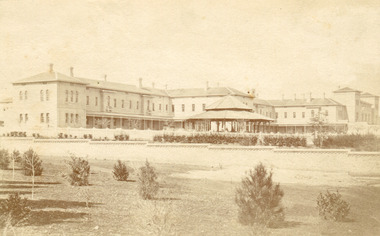
Photograph, Bayless C. - Manager, 1875
... was chosen for its panoramic view of the countryside, the hilltop... was chosen for its panoramic view of the countryside, the hilltop ...In this photo, taken in around 1875, is depicted the exterior of the Beechworth Mental Asylum buildings, with the administration buildings far right of the photo. A sunken boundary wall in the foreground and some people in view, sitting at the pavillion in the centre of the image. The two-storey buildings, designed in Italianate style, and the three-storey towers at the front, influenced by the asylum at Colney Hatch in England. The architecture of the buildings shares key features with other contemporary institutions, like Aradale at Ararat, and its design is attributed to the Public Works Department architect, J.J. Clark, whose name is connected with the construction of many other important public buildings, such as the Asylums at Kew and Ararat, the front block of the Royal Mint, Melbourne and the Melbourne Customs House. The Mayday Hills Hospital was constructed between 1864 and 1867, with buildings created in a number of periods. It formally opened on 24 October 1867 and, along with the Ovens Hospital and the Benevolent Asylum, made Beechworth a prominent social welfare centre in Victoria. Large masses of granite were excavated for its foundation and around 250 workmen were employed for its construction. The building, divided into six sections, was comprised of dormitories, doctors` rooms and plenty ancillary rooms and facilities, such as laundries, reading rooms, a concert hall and cooking areas. The site was chosen for its panoramic view of the countryside, the hilltop atmosphere and the native fauna, all contributing to the cure of patients. The Hospital was originally named the “Ovens Lunatic Asylum” but during the centenary celebrations in 1967 the name was officially changed to “Mayday Hills Hospital”, showing the gradual shift in the perception and understanding of mental health conditions over the last decades. The Hospital lies on the traditional land of the Kulin Nation.This photograph is historically significant as it provides an insight into the location, surroundings and the exterior of the Mayday Hills Hospital at the end of the 19th century. It also contributes to the understanding of the district`s development and its importance to the course of Victoria`s history and is acknowledged as a unique construction, being one of three identified as the largest of their kind.Black and white rectangular photograph printed on matte photographic paper mounted on board.Reverse: 37/ 3443/ Beechworth Asylum about 1875/ American & Australasian/Photographic Company/Victoria Branch./C.Bayless, Manager./ No./beechworth mental asylum, aradale, public works department, j.j. clark, melbourne customs house, colney hatch, italianate style, mayday hills hospital, royal mint, granite, benevolent asylum, dormitories, ovens lunatic asylum, ancillary rooms, centenary celebrations, three-storey towers, countryside, mental health conditions, kulin nation, concert hall -
 The Beechworth Burke Museum
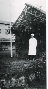
Photograph - Photograph Reproduction, 1998
... was chosen for its panoramic view of the countryside, the hilltop... was chosen for its panoramic view of the countryside, the hilltop ...The photograph, created in 1998, is a copy of the original one, depicting a nurse in uniform at the Mental Hospital in Beechworth, with a fern house behind her. In the background, the two-storey building is in view, along with the covered walkway. The institution had to operate with serious shortage of female nurses for long periods of time. During the 1880s, small houses (cottages) were built to offer accommodation for the nurses living in the hospital and in 1937 began the construction of a nurses` hostel. In 1962 the upper level of the Nurses` Home was converted into a Nurses` Training School. The Mayday Hills Hospital was constructed between 1864 and 1867, with buildings created in a number of periods. It formally opened on 24 October 1867 and, along with the Ovens Hospital and the Benevolent Asylum, made Beechworth a prominent social welfare centre in Victoria. The need for an institution of this kind was arisen due to the increased number of people with mental disturbances (induced by the harsh living conditions on the goldfields) and the remoteness of the district from Melbourne. The two-storey buildings, designed in Italianate style, and the three-storey towers at the front, were influenced by the asylum at Colney Hatch in England. Large masses of granite were excavated for its foundation and around 250 workmen were employed for its construction. The building, divided into six sections, was comprised of dormitories, doctors` rooms and plenty ancillary rooms and facilities, such as laundries, reading rooms, a concert hall and cooking areas. The site was chosen for its panoramic view of the countryside, the hilltop atmosphere and the native fauna, all contributing to the cure of patients. The Hospital was originally named the “Ovens Lunatic Asylum” but, during the centenary celebrations in 1967, the name was officially changed to “Mayday Hills Hospital”, showing the gradual shift in the perception and understanding of mental health conditions over the last decades. The Hospital lies on the traditional land of the Kulin Nation.This photograph is historically significant as it provides an insight into the everyday life of staff living within the walls of the Mayday Hills Hospital. It also offers important information about the location and the exterior of the Hospital and contributes to the understanding of the district`s development and its importance to the course of Victoria`s history.Black and white rectangular photograph printed on paper unframed.Reverse: 3445/mental hospital, beechworth, fern house, female nurses, nurses` home, nurses` training school, nurses` hostel, mayday hills hospital, ovens hospital, colney hatch, two-storey buildings, italianate style, benevolent asylum, ovens lunatic asylum, kulin nation, workmen, covered walkway, granite, hilltop atmosphere, mental health -
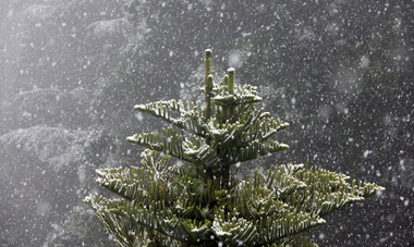 Ballarat Heritage Services
Photograph - Digital photographs, L.J. Gervasoni, Snow at the Wombat Hill Botanic Gardens, Daylesford, c2012-2016
... spectacularly sited on an extinct volcanic cone which allows a panoramic... spectacularly sited on an extinct volcanic cone which allows a panoramic ...The Daylesford Botanic Gardens are of historic, scientific (botanic), and aesthetic significance to the State of Victoria. The Daylesford Botanic Gardens are historically significant as a fine example of a regional botanic garden demonstrating the typical characteristics of a carriage drive, informal park layout, decorative structures and works such as the memorial tower, conservatory, rotunda, cascade and fernery, which contrasts with the open lawns planted with specimen trees, areas of intensive horticultural interest and close proximity to a township developed during the mid to late nineteenth century. The Daylesford Botanic Gardens are historically significant for the design input by noted landscape designer William Sangster, and for the survival of his 1884 plan, which is a rare example of a plan from this prolific garden designer. The Daylesford Botanic Gardens are of scientific (botanic) significance for the extensive conifer collection and cool climate plants. The Gardens contain an outstanding collection of conifers and other mature trees, many of which were donated by renowned botanist Ferdinand von Mueller. Significant trees include Pinus ponderosa (Western Yellow Pine), Pinus coulteri (Big Cone Pine), twoAbies nordmanniana (Caucasian Fir), Abies pinsapo, (Spanish Fir) and a Cedrus atlantica f. glauca(Blue Atlas Cedar), Pinus wallichiana (Bhutan Pine), Pinus pinaster (Maritime Pine), Sequoiadendron giganteum (Giant Redwood), (Monkey Puzzle) and Aesculus hippocastanum (Horse Chestnut), many the largest or finest examples in Victoria. Other outstanding trees include a Tilia cordata (Small-leaved European Linden), a row of Cupressus lusitanica (Mexican cypress), a Quercus robur (English Oak) planted in 1863, avenues of Dutch Elms and a rare Quercus leucotrichophora (Himalayan Oak). The Daylesford Botanic Gardens are of aesthetic significance as a rare example of a botanic garden spectacularly sited on an extinct volcanic cone which allows a panoramic view, aided by the 1938 Pioneers’ Memorial Tower, as well as vistas within and out of the gardens and from the township to the gardens. As the most prominent local landmark, the Garden’s vertical dominance in the landscape provides a dark contrast to the elms avenues, oaks and other deciduous species. (Heritage Victoria Register, )Digital imagesdaylesford, snow, weather, climate, winter, daylesford botanic gardens, botanic gardens, wombat hill, wombat hill botanic gardens, pinetum, trees, reservoir -
 Ballarat Heritage Services
Photograph - Postcard, Wombat Hill Gardens, Daylesford
... spectacularly sited on an extinct volcanic cone which allows a panoramic... spectacularly sited on an extinct volcanic cone which allows a panoramic ...The Daylesford Botanic Gardens are of historic, scientific (botanic), and aesthetic significance to the State of Victoria. The Daylesford Botanic Gardens are historically significant as a fine example of a regional botanic garden demonstrating the typical characteristics of a carriage drive, informal park layout, decorative structures and works such as the memorial tower, conservatory, rotunda, cascade and fernery, which contrasts with the open lawns planted with specimen trees, areas of intensive horticultural interest and close proximity to a township developed during the mid to late nineteenth century. The Daylesford Botanic Gardens are historically significant for the design input by noted landscape designer William Sangster, and for the survival of his 1884 plan, which is a rare example of a plan from this prolific garden designer. The Daylesford Botanic Gardens are of scientific (botanic) significance for the extensive conifer collection and cool climate plants. The Gardens contain an outstanding collection of conifers and other mature trees, many of which were donated by renowned botanist Ferdinand von Mueller. Significant trees include Pinus ponderosa (Western Yellow Pine), Pinus coulteri (Big Cone Pine), twoAbies nordmanniana (Caucasian Fir), Abies pinsapo, (Spanish Fir) and a Cedrus atlantica f. glauca(Blue Atlas Cedar), Pinus wallichiana (Bhutan Pine), Pinus pinaster (Maritime Pine), Sequoiadendron giganteum (Giant Redwood), (Monkey Puzzle) and Aesculus hippocastanum (Horse Chestnut), many the largest or finest examples in Victoria. Other outstanding trees include a Tilia cordata (Small-leaved European Linden), a row of Cupressus lusitanica (Mexican cypress), a Quercus robur (English Oak) planted in 1863, avenues of Dutch Elms and a rare Quercus leucotrichophora (Himalayan Oak). The Daylesford Botanic Gardens are of aesthetic significance as a rare example of a botanic garden spectacularly sited on an extinct volcanic cone which allows a panoramic view, aided by the 1938 Pioneers’ Memorial Tower, as well as vistas within and out of the gardens and from the township to the gardens. As the most prominent local landmark, the Garden’s vertical dominance in the landscape provides a dark contrast to the elms avenues, oaks and other deciduous species. (Heritage Victoria Register, )Black and white postcard of Wombat Hill Botanical Gardens, Daylesford.wombat hill botanical gardens, daylesford, gardener, wombat hill botanic gardens -
 Ballarat Heritage Services
Photograph - Digital photographs, L.J. Gervasoni, Wombat Hill Botanic Gardens 150 anniversary event Daylesford community event, 2013
... spectacularly sited on an extinct volcanic cone which allows a panoramic... spectacularly sited on an extinct volcanic cone which allows a panoramic ...The Daylesford Botanic Gardens are of historic, scientific (botanic), and aesthetic significance to the State of Victoria. The Daylesford Botanic Gardens are historically significant as a fine example of a regional botanic garden demonstrating the typical characteristics of a carriage drive, informal park layout, decorative structures and works such as the memorial tower, conservatory, rotunda, cascade and fernery, which contrasts with the open lawns planted with specimen trees, areas of intensive horticultural interest and close proximity to a township developed during the mid to late nineteenth century. The Daylesford Botanic Gardens are historically significant for the design input by noted landscape designer William Sangster, and for the survival of his 1884 plan, which is a rare example of a plan from this prolific garden designer. The Daylesford Botanic Gardens are of scientific (botanic) significance for the extensive conifer collection and cool climate plants. The Gardens contain an outstanding collection of conifers and other mature trees, many of which were donated by renowned botanist Ferdinand von Mueller. Significant trees include Pinus ponderosa (Western Yellow Pine), Pinus coulteri (Big Cone Pine), twoAbies nordmanniana (Caucasian Fir), Abies pinsapo, (Spanish Fir) and a Cedrus atlantica f. glauca(Blue Atlas Cedar), Pinus wallichiana (Bhutan Pine), Pinus pinaster (Maritime Pine), Sequoiadendron giganteum (Giant Redwood), (Monkey Puzzle) and Aesculus hippocastanum (Horse Chestnut), many the largest or finest examples in Victoria. Other outstanding trees include a Tilia cordata (Small-leaved European Linden), a row of Cupressus lusitanica (Mexican cypress), a Quercus robur (English Oak) planted in 1863, avenues of Dutch Elms and a rare Quercus leucotrichophora (Himalayan Oak). The Daylesford Botanic Gardens are of aesthetic significance as a rare example of a botanic garden spectacularly sited on an extinct volcanic cone which allows a panoramic view, aided by the 1938 Pioneers’ Memorial Tower, as well as vistas within and out of the gardens and from the township to the gardens. As the most prominent local landmark, the Garden’s vertical dominance in the landscape provides a dark contrast to the elms avenues, oaks and other deciduous species. (Heritage Victoria Register, )Digital imagesvictoria, 150, anniversary, botanic, gardens, wombat hill, botanic gardens, heritage, celebration, garden party, daylesford, people, crowd, community, john hawker, john madigan, stilt, trees, owls, wombat hill botanic gardens -
 Ballarat Heritage Services
Photograph - digital photographs, Lisa Gervasoni, Wombat Hill, Daylesford, c2006-2016
... spectacularly sited on an extinct volcanic cone which allows a panoramic... spectacularly sited on an extinct volcanic cone which allows a panoramic ...The Daylesford Botanic Gardens are of historic, scientific (botanic), and aesthetic significance to the State of Victoria. The Daylesford Botanic Gardens are historically significant as a fine example of a regional botanic garden demonstrating the typical characteristics of a carriage drive, informal park layout, decorative structures and works such as the memorial tower, conservatory, rotunda, cascade and fernery, which contrasts with the open lawns planted with specimen trees, areas of intensive horticultural interest and close proximity to a township developed during the mid to late nineteenth century. The Daylesford Botanic Gardens are historically significant for the design input by noted landscape designer William Sangster, and for the survival of his 1884 plan, which is a rare example of a plan from this prolific garden designer. The Daylesford Botanic Gardens are of scientific (botanic) significance for the extensive conifer collection and cool climate plants. The Gardens contain an outstanding collection of conifers and other mature trees, many of which were donated by renowned botanist Ferdinand von Mueller. Significant trees include Pinus ponderosa (Western Yellow Pine), Pinus coulteri (Big Cone Pine), twoAbies nordmanniana (Caucasian Fir), Abies pinsapo, (Spanish Fir) and a Cedrus atlantica f. glauca(Blue Atlas Cedar), Pinus wallichiana (Bhutan Pine), Pinus pinaster (Maritime Pine), Sequoiadendron giganteum (Giant Redwood), (Monkey Puzzle) and Aesculus hippocastanum (Horse Chestnut), many the largest or finest examples in Victoria. Other outstanding trees include a Tilia cordata (Small-leaved European Linden), a row of Cupressus lusitanica (Mexican cypress), a Quercus robur (English Oak) planted in 1863, avenues of Dutch Elms and a rare Quercus leucotrichophora (Himalayan Oak). The Daylesford Botanic Gardens are of aesthetic significance as a rare example of a botanic garden spectacularly sited on an extinct volcanic cone which allows a panoramic view, aided by the 1938 Pioneers’ Memorial Tower, as well as vistas within and out of the gardens and from the township to the gardens. As the most prominent local landmark, the Garden’s vertical dominance in the landscape provides a dark contrast to the elms avenues, oaks and other deciduous species. (Heritage Victoria Register, )Colour photograph of Wombat Hill Botanical Gardens, Daylesford.heritage, daylesford, townscape, wombat hill, wombat hill botanical gardens, wombat hill botanic gardens -
 Ballarat Heritage Services
Photograph - Digital photographs, L.J. Gervasoni, Wombat Hill in the Fog, c2015
... spectacularly sited on an extinct volcanic cone which allows a panoramic... spectacularly sited on an extinct volcanic cone which allows a panoramic ...The Daylesford Botanic Gardens are of historic, scientific (botanic), and aesthetic significance to the State of Victoria. The Daylesford Botanic Gardens are historically significant as a fine example of a regional botanic garden demonstrating the typical characteristics of a carriage drive, informal park layout, decorative structures and works such as the memorial tower, conservatory, rotunda, cascade and fernery, which contrasts with the open lawns planted with specimen trees, areas of intensive horticultural interest and close proximity to a township developed during the mid to late nineteenth century. The Daylesford Botanic Gardens are historically significant for the design input by noted landscape designer William Sangster, and for the survival of his 1884 plan, which is a rare example of a plan from this prolific garden designer. The Daylesford Botanic Gardens are of scientific (botanic) significance for the extensive conifer collection and cool climate plants. The Gardens contain an outstanding collection of conifers and other mature trees, many of which were donated by renowned botanist Ferdinand von Mueller. Significant trees include Pinus ponderosa (Western Yellow Pine), Pinus coulteri (Big Cone Pine), twoAbies nordmanniana (Caucasian Fir), Abies pinsapo, (Spanish Fir) and a Cedrus atlantica f. glauca(Blue Atlas Cedar), Pinus wallichiana (Bhutan Pine), Pinus pinaster (Maritime Pine), Sequoiadendron giganteum (Giant Redwood), (Monkey Puzzle) and Aesculus hippocastanum (Horse Chestnut), many the largest or finest examples in Victoria. Other outstanding trees include a Tilia cordata (Small-leaved European Linden), a row of Cupressus lusitanica (Mexican cypress), a Quercus robur (English Oak) planted in 1863, avenues of Dutch Elms and a rare Quercus leucotrichophora (Himalayan Oak). The Daylesford Botanic Gardens are of aesthetic significance as a rare example of a botanic garden spectacularly sited on an extinct volcanic cone which allows a panoramic view, aided by the 1938 Pioneers’ Memorial Tower, as well as vistas within and out of the gardens and from the township to the gardens. As the most prominent local landmark, the Garden’s vertical dominance in the landscape provides a dark contrast to the elms avenues, oaks and other deciduous species. (Heritage Victoria Register, )Black and white photograph of a treed landscape covered with fog. The trees are in the Daylesford Botanical Gardens on Wombat Hill.wombat hill botanic gardens, wombat hill, daylesford, daylesford botanic gardens, fog, weather, arboretum -
 Ballarat Heritage Services
Photograph - Photograph - Colour, Clare Gervasoni, Wombat Botanic Gardens, Daylesford, 2019, 23/04/2019
... spectacularly sited on an extinct volcanic cone which allows a panoramic... spectacularly sited on an extinct volcanic cone which allows a panoramic ...The Daylesford Botanic Gardens are of historic, scientific (botanic), and aesthetic significance to the State of Victoria. The Daylesford Botanic Gardens are historically significant as a fine example of a regional botanic garden demonstrating the typical characteristics of a carriage drive, informal park layout, decorative structures and works such as the memorial tower, conservatory, rotunda, cascade and fernery, which contrasts with the open lawns planted with specimen trees, areas of intensive horticultural interest and close proximity to a township developed during the mid to late nineteenth century. The Daylesford Botanic Gardens are historically significant for the design input by noted landscape designer William Sangster, and for the survival of his 1884 plan, which is a rare example of a plan from this prolific garden designer. The Daylesford Botanic Gardens are of scientific (botanic) significance for the extensive conifer collection and cool climate plants. The Gardens contain an outstanding collection of conifers and other mature trees, many of which were donated by renowned botanist Ferdinand von Mueller. Significant trees include Pinus ponderosa (Western Yellow Pine), Pinus coulteri (Big Cone Pine), twoAbies nordmanniana (Caucasian Fir), Abies pinsapo, (Spanish Fir) and a Cedrus atlantica f. glauca(Blue Atlas Cedar), Pinus wallichiana (Bhutan Pine), Pinus pinaster (Maritime Pine), Sequoiadendron giganteum (Giant Redwood), (Monkey Puzzle) and Aesculus hippocastanum (Horse Chestnut), many the largest or finest examples in Victoria. Other outstanding trees include a Tilia cordata (Small-leaved European Linden), a row of Cupressus lusitanica (Mexican cypress), a Quercus robur (English Oak) planted in 1863, avenues of Dutch Elms and a rare Quercus leucotrichophora (Himalayan Oak). The Daylesford Botanic Gardens are of aesthetic significance as a rare example of a botanic garden spectacularly sited on an extinct volcanic cone which allows a panoramic view, aided by the 1938 Pioneers’ Memorial Tower, as well as vistas within and out of the gardens and from the township to the gardens. As the most prominent local landmark, the Garden’s vertical dominance in the landscape provides a dark contrast to the elms avenues, oaks and other deciduous species. (Heritage Victoria Register, )A tree in the Wombat Hill Gardens.wombat botanical gardens, daylesford botanical gardens, daylesford, trees, wombat hill botanic gardens -
 Ballarat Heritage Services
Photograph - Photograph - Colour, Clare Gervasoni, Wombat Botanic Gardens, Daylesford, 2019, 23/04/2019
... spectacularly sited on an extinct volcanic cone which allows a panoramic... spectacularly sited on an extinct volcanic cone which allows a panoramic ...The Daylesford Botanic Gardens are of historic, scientific (botanic), and aesthetic significance to the State of Victoria. The Daylesford Botanic Gardens are historically significant as a fine example of a regional botanic garden demonstrating the typical characteristics of a carriage drive, informal park layout, decorative structures and works such as the memorial tower, conservatory, rotunda, cascade and fernery, which contrasts with the open lawns planted with specimen trees, areas of intensive horticultural interest and close proximity to a township developed during the mid to late nineteenth century. The Daylesford Botanic Gardens are historically significant for the design input by noted landscape designer William Sangster, and for the survival of his 1884 plan, which is a rare example of a plan from this prolific garden designer. The Daylesford Botanic Gardens are of scientific (botanic) significance for the extensive conifer collection and cool climate plants. The Gardens contain an outstanding collection of conifers and other mature trees, many of which were donated by renowned botanist Ferdinand von Mueller. Significant trees include Pinus ponderosa (Western Yellow Pine), Pinus coulteri (Big Cone Pine), twoAbies nordmanniana (Caucasian Fir), Abies pinsapo, (Spanish Fir) and a Cedrus atlantica f. glauca(Blue Atlas Cedar), Pinus wallichiana (Bhutan Pine), Pinus pinaster (Maritime Pine), Sequoiadendron giganteum (Giant Redwood), (Monkey Puzzle) and Aesculus hippocastanum (Horse Chestnut), many the largest or finest examples in Victoria. Other outstanding trees include a Tilia cordata (Small-leaved European Linden), a row of Cupressus lusitanica (Mexican cypress), a Quercus robur (English Oak) planted in 1863, avenues of Dutch Elms and a rare Quercus leucotrichophora (Himalayan Oak). The Daylesford Botanic Gardens are of aesthetic significance as a rare example of a botanic garden spectacularly sited on an extinct volcanic cone which allows a panoramic view, aided by the 1938 Pioneers’ Memorial Tower, as well as vistas within and out of the gardens and from the township to the gardens. As the most prominent local landmark, the Garden’s vertical dominance in the landscape provides a dark contrast to the elms avenues, oaks and other deciduous species. (Heritage Victoria Register, 2025)An avenue of trees in the Wombat Hill Gardens. wombat botanical gardens, daylesford botanical gardens, daylesford, trees -
 Ballarat Heritage Services
Photograph - Photograph - Colour, Clare Gervasoni, Wombat Botanic Gardens, Daylesford, 2019, 23/04/2019
... spectacularly sited on an extinct volcanic cone which allows a panoramic... spectacularly sited on an extinct volcanic cone which allows a panoramic ...The Daylesford Botanic Gardens are of historic, scientific (botanic), and aesthetic significance to the State of Victoria. The Daylesford Botanic Gardens are historically significant as a fine example of a regional botanic garden demonstrating the typical characteristics of a carriage drive, informal park layout, decorative structures and works such as the memorial tower, conservatory, rotunda, cascade and fernery, which contrasts with the open lawns planted with specimen trees, areas of intensive horticultural interest and close proximity to a township developed during the mid to late nineteenth century. The Daylesford Botanic Gardens are historically significant for the design input by noted landscape designer William Sangster, and for the survival of his 1884 plan, which is a rare example of a plan from this prolific garden designer. The Daylesford Botanic Gardens are of scientific (botanic) significance for the extensive conifer collection and cool climate plants. The Gardens contain an outstanding collection of conifers and other mature trees, many of which were donated by renowned botanist Ferdinand von Mueller. Significant trees include Pinus ponderosa (Western Yellow Pine), Pinus coulteri (Big Cone Pine), twoAbies nordmanniana (Caucasian Fir), Abies pinsapo, (Spanish Fir) and a Cedrus atlantica f. glauca(Blue Atlas Cedar), Pinus wallichiana (Bhutan Pine), Pinus pinaster (Maritime Pine), Sequoiadendron giganteum (Giant Redwood), (Monkey Puzzle) and Aesculus hippocastanum (Horse Chestnut), many the largest or finest examples in Victoria. Other outstanding trees include a Tilia cordata (Small-leaved European Linden), a row of Cupressus lusitanica (Mexican cypress), a Quercus robur (English Oak) planted in 1863, avenues of Dutch Elms and a rare Quercus leucotrichophora (Himalayan Oak). The Daylesford Botanic Gardens are of aesthetic significance as a rare example of a botanic garden spectacularly sited on an extinct volcanic cone which allows a panoramic view, aided by the 1938 Pioneers’ Memorial Tower, as well as vistas within and out of the gardens and from the township to the gardens. As the most prominent local landmark, the Garden’s vertical dominance in the landscape provides a dark contrast to the elms avenues, oaks and other deciduous species. (Heritage Victoria Register, 2025)A large tree in the Wombat Gardens. wombat botanical gardens, daylesford botanical gardens, daylesford, trees, lisa gervasoni, wombat botanic gardens -
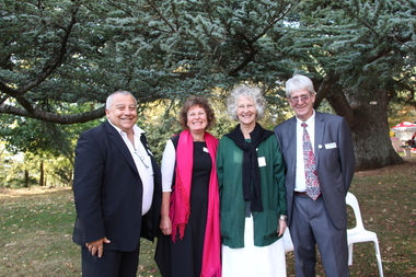 Ballarat Heritage Services
Photograph - Digital photographs, L.J. Gervasoni, Wombat Hill Botanic Gardens 150 anniversary event Daylesford organiser Gael Shannon, 2013
... spectacularly sited on an extinct volcanic cone which allows a panoramic... spectacularly sited on an extinct volcanic cone which allows a panoramic ...The Wombat Hill Botanic Gardens 150 anniversary event organiser was Gael Shannon. The Daylesford Botanic Gardens are of historic, scientific (botanic), and aesthetic significance to the State of Victoria. The Daylesford Botanic Gardens are historically significant as a fine example of a regional botanic garden demonstrating the typical characteristics of a carriage drive, informal park layout, decorative structures and works such as the memorial tower, conservatory, rotunda, cascade and fernery, which contrasts with the open lawns planted with specimen trees, areas of intensive horticultural interest and close proximity to a township developed during the mid to late nineteenth century. The Daylesford Botanic Gardens are historically significant for the design input by noted landscape designer William Sangster, and for the survival of his 1884 plan, which is a rare example of a plan from this prolific garden designer. The Daylesford Botanic Gardens are of scientific (botanic) significance for the extensive conifer collection and cool climate plants. The Gardens contain an outstanding collection of conifers and other mature trees, many of which were donated by renowned botanist Ferdinand von Mueller. Significant trees include Pinus ponderosa (Western Yellow Pine), Pinus coulteri (Big Cone Pine), twoAbies nordmanniana (Caucasian Fir), Abies pinsapo, (Spanish Fir) and a Cedrus atlantica f. glauca(Blue Atlas Cedar), Pinus wallichiana (Bhutan Pine), Pinus pinaster (Maritime Pine), Sequoiadendron giganteum (Giant Redwood), (Monkey Puzzle) and Aesculus hippocastanum (Horse Chestnut), many the largest or finest examples in Victoria. Other outstanding trees include a Tilia cordata (Small-leaved European Linden), a row of Cupressus lusitanica (Mexican cypress), a Quercus robur (English Oak) planted in 1863, avenues of Dutch Elms and a rare Quercus leucotrichophora (Himalayan Oak). The Daylesford Botanic Gardens are of aesthetic significance as a rare example of a botanic garden spectacularly sited on an extinct volcanic cone which allows a panoramic view, aided by the 1938 Pioneers’ Memorial Tower, as well as vistas within and out of the gardens and from the township to the gardens. As the most prominent local landmark, the Garden’s vertical dominance in the landscape provides a dark contrast to the elms avenues, oaks and other deciduous species. (Heritage Victoria Register, )Four people photographed at the 150th anniversary event at the Wombat Botanic Gardens.victoria, 150, anniversary, botanic, gardens, wombat hill, botanic gardens, heritage, celebration, garden party, daylesford, people, crowd, community, organiser, tour, gael shannon, don henderson, wombat hill botanic gardens -
 Eltham District Historical Society Inc
Photograph, Murchison Gap, Autumn Excursion, Hume and Hovell's 1824 expedition, 26 May 1996, 26/05/1996
... enjoyed a private tour, panoramic views over Melbourne... enjoyed a private tour, panoramic views over Melbourne ...[article by Bettina Woodburn in EDHS Newsletter No. 109, July 1996:] ON THE TRAIL OF HUME AND HOVELL - REPORT ON THE AUTUMN EXCURSION - On a green and fresh morning (Sunday 26th May 1996) the Cobb and Co coach (driven by the most obliging Peter Tampion) set off in a north easterly direction from Eltham to connect with Hume and Hovell's route on their 1824 explorations of central Victoria. The Society would follow a series of monuments erected for the 1924 centenary of the expedition from King Parrot Creek (Tuesday 7th December 1824), through Strath Creek, over Sunday Creek (Sunday 12th December 1824) at Broadford, Tullamarine, St Albans, Deer Park, through Werribee, skirting east of the You Yangs to Lara and Avalon Beach. Because their distance-measuring wheel had broken and a one degree mistake was made in calculations, the two leaders of the original group of six convict-companions arrived at Corio Bay, instead of the expected Western Port, discovered earlier by Flinders. From below Mt. Disappointment (Hume and Hovell's difficulties in "scrambling over brush and rock", "leeches in forest, as well as no water", "cutting grass 4-5 ft. high", dreadful scrub", "devil flies") we took an easier route, saw the Strath Creek memorial in ground fog and a wonderful "field of dreams", the Hume-Hovell privately owned cricket ground with its white picket boundary fence. Now, after a steep climb, in sunshine under gums we stretched and viewed magnificent rolling hills and fog-filled valleys - not "smoke from Aborigines' bush fires". After morning tea at Broadford we followed the Sunday Creek valley beside the Hume Freeway, passed the Wallan Wallan Rest Area (more appropriately Hume and Hovell Rest Area) to tum right at Beveridge. In Gellibrand Hill Park, near the headwaters of the Moonee Ponds Creek, we experienced the landscape the first European settlers saw - huge river red gums and rolling pastures. The gardens and sheltered courtyard of the 1840s, timber, brought from .....[?] prefabricated Woodlands Homestead, provided a pleasant lunch stop. We enjoyed a private tour, panoramic views over Melbourne and surroundings and the excitement of arriving and departing aircraft. Our next river crossing was at Werribee, "in a vast treeless plain", then we drove on by-ways no coach had previously travelled, to find "an immense sheet of water" salty Corio Bay, off-course to the west. In late afternoon of a super, calm, late autumn day we headed homewards. Back at Eltham we were rather surprised to find that we had travelled a total of 347 km. Thanks again to Russell Yeoman for his research and organization. What a wonderful day! Three colour photographsactivities, murchison gap, murchison valley -
 Eltham District Historical Society Inc
Photograph, Hume and Hovell Monument, Broadford, Autumn Excursion, Hume and Hovell's 1824 expedition, 26 May 1996, 26/05/1996
... enjoyed a private tour, panoramic views over Melbourne... enjoyed a private tour, panoramic views over Melbourne ...[article by Bettina Woodburn in EDHS Newsletter No. 109, July 1996:] ON THE TRAIL OF HUME AND HOVELL - REPORT ON THE AUTUMN EXCURSION - On a green and fresh morning (Sunday 26th May 1996) the Cobb and Co coach (driven by the most obliging Peter Tampion) set off in a north easterly direction from Eltham to connect with Hume and Hovell's route on their 1824 explorations of central Victoria. The Society would follow a series of monuments erected for the 1924 centenary of the expedition from King Parrot Creek (Tuesday 7th December 1824), through Strath Creek, over Sunday Creek (Sunday 12th December 1824) at Broadford, Tullamarine, St Albans, Deer Park, through Werribee, skirting east of the You Yangs to Lara and Avalon Beach. Because their distance-measuring wheel had broken and a one degree mistake was made in calculations, the two leaders of the original group of six convict-companions arrived at Corio Bay, instead of the expected Western Port, discovered earlier by Flinders. From below Mt. Disappointment (Hume and Hovell's difficulties in "scrambling over brush and rock", "leeches in forest, as well as no water", "cutting grass 4-5 ft. high", dreadful scrub", "devil flies") we took an easier route, saw the Strath Creek memorial in ground fog and a wonderful "field of dreams", the Hume-Hovell privately owned cricket ground with its white picket boundary fence. Now, after a steep climb, in sunshine under gums we stretched and viewed magnificent rolling hills and fog-filled valleys - not "smoke from Aborigines' bush fires". After morning tea at Broadford we followed the Sunday Creek valley beside the Hume Freeway, passed the Wallan Wallan Rest Area (more appropriately Hume and Hovell Rest Area) to tum right at Beveridge. In Gellibrand Hill Park, near the headwaters of the Moonee Ponds Creek, we experienced the landscape the first European settlers saw - huge river red gums and rolling pastures. The gardens and sheltered courtyard of the 1840s, timber, brought from .....[?] prefabricated Woodlands Homestead, provided a pleasant lunch stop. We enjoyed a private tour, panoramic views over Melbourne and surroundings and the excitement of arriving and departing aircraft. Our next river crossing was at Werribee, "in a vast treeless plain", then we drove on by-ways no coach had previously travelled, to find "an immense sheet of water" salty Corio Bay, off-course to the west. In late afternoon of a super, calm, late autumn day we headed homewards. Back at Eltham we were rather surprised to find that we had travelled a total of 347 km. Thanks again to Russell Yeoman for his research and organization. What a wonderful day! Colour photographactivities, broadford, hume and hovell, monument -
 Eltham District Historical Society Inc
Photograph, Hume and Hovell Monument, Autumn Excursion, Hume and Hovell's 1824 expedition, 26 May 1996, 26/05/1996
... enjoyed a private tour, panoramic views over Melbourne... enjoyed a private tour, panoramic views over Melbourne ...[article by Bettina Woodburn in EDHS Newsletter No. 109, July 1996:] ON THE TRAIL OF HUME AND HOVELL - REPORT ON THE AUTUMN EXCURSION - On a green and fresh morning (Sunday 26th May 1996) the Cobb and Co coach (driven by the most obliging Peter Tampion) set off in a north easterly direction from Eltham to connect with Hume and Hovell's route on their 1824 explorations of central Victoria. The Society would follow a series of monuments erected for the 1924 centenary of the expedition from King Parrot Creek (Tuesday 7th December 1824), through Strath Creek, over Sunday Creek (Sunday 12th December 1824) at Broadford, Tullamarine, St Albans, Deer Park, through Werribee, skirting east of the You Yangs to Lara and Avalon Beach. Because their distance-measuring wheel had broken and a one degree mistake was made in calculations, the two leaders of the original group of six convict-companions arrived at Corio Bay, instead of the expected Western Port, discovered earlier by Flinders. From below Mt. Disappointment (Hume and Hovell's difficulties in "scrambling over brush and rock", "leeches in forest, as well as no water", "cutting grass 4-5 ft. high", dreadful scrub", "devil flies") we took an easier route, saw the Strath Creek memorial in ground fog and a wonderful "field of dreams", the Hume-Hovell privately owned cricket ground with its white picket boundary fence. Now, after a steep climb, in sunshine under gums we stretched and viewed magnificent rolling hills and fog-filled valleys - not "smoke from Aborigines' bush fires". After morning tea at Broadford we followed the Sunday Creek valley beside the Hume Freeway, passed the Wallan Wallan Rest Area (more appropriately Hume and Hovell Rest Area) to tum right at Beveridge. In Gellibrand Hill Park, near the headwaters of the Moonee Ponds Creek, we experienced the landscape the first European settlers saw - huge river red gums and rolling pastures. The gardens and sheltered courtyard of the 1840s, timber, brought from .....[?] prefabricated Woodlands Homestead, provided a pleasant lunch stop. We enjoyed a private tour, panoramic views over Melbourne and surroundings and the excitement of arriving and departing aircraft. Our next river crossing was at Werribee, "in a vast treeless plain", then we drove on by-ways no coach had previously travelled, to find "an immense sheet of water" salty Corio Bay, off-course to the west. In late afternoon of a super, calm, late autumn day we headed homewards. Back at Eltham we were rather surprised to find that we had travelled a total of 347 km. Thanks again to Russell Yeoman for his research and organization. What a wonderful day! Two colour photographsactivities, hume and hovell, monument -
 Eltham District Historical Society Inc
Photograph, Hume and Hovell Monument, Broadford, Autumn Excursion, Hume and Hovell's 1824 expedition, 26 May 1996, 26/05/1996
... enjoyed a private tour, panoramic views over Melbourne... enjoyed a private tour, panoramic views over Melbourne ...[article by Bettina Woodburn in EDHS Newsletter No. 109, July 1996:] ON THE TRAIL OF HUME AND HOVELL - REPORT ON THE AUTUMN EXCURSION - On a green and fresh morning (Sunday 26th May 1996) the Cobb and Co coach (driven by the most obliging Peter Tampion) set off in a north easterly direction from Eltham to connect with Hume and Hovell's route on their 1824 explorations of central Victoria. The Society would follow a series of monuments erected for the 1924 centenary of the expedition from King Parrot Creek (Tuesday 7th December 1824), through Strath Creek, over Sunday Creek (Sunday 12th December 1824) at Broadford, Tullamarine, St Albans, Deer Park, through Werribee, skirting east of the You Yangs to Lara and Avalon Beach. Because their distance-measuring wheel had broken and a one degree mistake was made in calculations, the two leaders of the original group of six convict-companions arrived at Corio Bay, instead of the expected Western Port, discovered earlier by Flinders. From below Mt. Disappointment (Hume and Hovell's difficulties in "scrambling over brush and rock", "leeches in forest, as well as no water", "cutting grass 4-5 ft. high", dreadful scrub", "devil flies") we took an easier route, saw the Strath Creek memorial in ground fog and a wonderful "field of dreams", the Hume-Hovell privately owned cricket ground with its white picket boundary fence. Now, after a steep climb, in sunshine under gums we stretched and viewed magnificent rolling hills and fog-filled valleys - not "smoke from Aborigines' bush fires". After morning tea at Broadford we followed the Sunday Creek valley beside the Hume Freeway, passed the Wallan Wallan Rest Area (more appropriately Hume and Hovell Rest Area) to tum right at Beveridge. In Gellibrand Hill Park, near the headwaters of the Moonee Ponds Creek, we experienced the landscape the first European settlers saw - huge river red gums and rolling pastures. The gardens and sheltered courtyard of the 1840s, timber, brought from .....[?] prefabricated Woodlands Homestead, provided a pleasant lunch stop. We enjoyed a private tour, panoramic views over Melbourne and surroundings and the excitement of arriving and departing aircraft. Our next river crossing was at Werribee, "in a vast treeless plain", then we drove on by-ways no coach had previously travelled, to find "an immense sheet of water" salty Corio Bay, off-course to the west. In late afternoon of a super, calm, late autumn day we headed homewards. Back at Eltham we were rather surprised to find that we had travelled a total of 347 km. Thanks again to Russell Yeoman for his research and organization. What a wonderful day! Colour photographactivities, broadford, hume and hovell, monument -
 Eltham District Historical Society Inc
Photograph, Strath Creek, Autumn Excursion, Hume and Hovell's 1824 expedition, 26 May 1996, 26/05/1996
... enjoyed a private tour, panoramic views over Melbourne... enjoyed a private tour, panoramic views over Melbourne ...[article by Bettina Woodburn in EDHS Newsletter No. 109, July 1996:] ON THE TRAIL OF HUME AND HOVELL - REPORT ON THE AUTUMN EXCURSION - On a green and fresh morning (Sunday 26th May 1996) the Cobb and Co coach (driven by the most obliging Peter Tampion) set off in a north easterly direction from Eltham to connect with Hume and Hovell's route on their 1824 explorations of central Victoria. The Society would follow a series of monuments erected for the 1924 centenary of the expedition from King Parrot Creek (Tuesday 7th December 1824), through Strath Creek, over Sunday Creek (Sunday 12th December 1824) at Broadford, Tullamarine, St Albans, Deer Park, through Werribee, skirting east of the You Yangs to Lara and Avalon Beach. Because their distance-measuring wheel had broken and a one degree mistake was made in calculations, the two leaders of the original group of six convict-companions arrived at Corio Bay, instead of the expected Western Port, discovered earlier by Flinders. From below Mt. Disappointment (Hume and Hovell's difficulties in "scrambling over brush and rock", "leeches in forest, as well as no water", "cutting grass 4-5 ft. high", dreadful scrub", "devil flies") we took an easier route, saw the Strath Creek memorial in ground fog and a wonderful "field of dreams", the Hume-Hovell privately owned cricket ground with its white picket boundary fence. Now, after a steep climb, in sunshine under gums we stretched and viewed magnificent rolling hills and fog-filled valleys - not "smoke from Aborigines' bush fires". After morning tea at Broadford we followed the Sunday Creek valley beside the Hume Freeway, passed the Wallan Wallan Rest Area (more appropriately Hume and Hovell Rest Area) to tum right at Beveridge. In Gellibrand Hill Park, near the headwaters of the Moonee Ponds Creek, we experienced the landscape the first European settlers saw - huge river red gums and rolling pastures. The gardens and sheltered courtyard of the 1840s, timber, brought from .....[?] prefabricated Woodlands Homestead, provided a pleasant lunch stop. We enjoyed a private tour, panoramic views over Melbourne and surroundings and the excitement of arriving and departing aircraft. Our next river crossing was at Werribee, "in a vast treeless plain", then we drove on by-ways no coach had previously travelled, to find "an immense sheet of water" salty Corio Bay, off-course to the west. In late afternoon of a super, calm, late autumn day we headed homewards. Back at Eltham we were rather surprised to find that we had travelled a total of 347 km. Thanks again to Russell Yeoman for his research and organization. What a wonderful day! Colour photographactivities, monument, hume and hovell, murchison valley, strath creek -
 Eltham District Historical Society Inc
Photograph, Murchison Gap viewed from Strath Creek, Autumn Excursion, Hume and Hovell's 1824 expedition, 26 May 1996, 26/05/1996
... enjoyed a private tour, panoramic views over Melbourne... enjoyed a private tour, panoramic views over Melbourne ...[article by Bettina Woodburn in EDHS Newsletter No. 109, July 1996:] ON THE TRAIL OF HUME AND HOVELL - REPORT ON THE AUTUMN EXCURSION - On a green and fresh morning (Sunday 26th May 1996) the Cobb and Co coach (driven by the most obliging Peter Tampion) set off in a north easterly direction from Eltham to connect with Hume and Hovell's route on their 1824 explorations of central Victoria. The Society would follow a series of monuments erected for the 1924 centenary of the expedition from King Parrot Creek (Tuesday 7th December 1824), through Strath Creek, over Sunday Creek (Sunday 12th December 1824) at Broadford, Tullamarine, St Albans, Deer Park, through Werribee, skirting east of the You Yangs to Lara and Avalon Beach. Because their distance-measuring wheel had broken and a one degree mistake was made in calculations, the two leaders of the original group of six convict-companions arrived at Corio Bay, instead of the expected Western Port, discovered earlier by Flinders. From below Mt. Disappointment (Hume and Hovell's difficulties in "scrambling over brush and rock", "leeches in forest, as well as no water", "cutting grass 4-5 ft. high", dreadful scrub", "devil flies") we took an easier route, saw the Strath Creek memorial in ground fog and a wonderful "field of dreams", the Hume-Hovell privately owned cricket ground with its white picket boundary fence. Now, after a steep climb, in sunshine under gums we stretched and viewed magnificent rolling hills and fog-filled valleys - not "smoke from Aborigines' bush fires". After morning tea at Broadford we followed the Sunday Creek valley beside the Hume Freeway, passed the Wallan Wallan Rest Area (more appropriately Hume and Hovell Rest Area) to tum right at Beveridge. In Gellibrand Hill Park, near the headwaters of the Moonee Ponds Creek, we experienced the landscape the first European settlers saw - huge river red gums and rolling pastures. The gardens and sheltered courtyard of the 1840s, timber, brought from .....[?] prefabricated Woodlands Homestead, provided a pleasant lunch stop. We enjoyed a private tour, panoramic views over Melbourne and surroundings and the excitement of arriving and departing aircraft. Our next river crossing was at Werribee, "in a vast treeless plain", then we drove on by-ways no coach had previously travelled, to find "an immense sheet of water" salty Corio Bay, off-course to the west. In late afternoon of a super, calm, late autumn day we headed homewards. Back at Eltham we were rather surprised to find that we had travelled a total of 347 km. Thanks again to Russell Yeoman for his research and organization. What a wonderful day! Colour photographactivities, hume and hovell, murchison valley, murchison gap, strath creek -
 Eltham District Historical Society Inc
Photograph, Murchison Gap viewed from Strath Creek, Autumn Excursion, Hume and Hovell's 1824 expedition, 26 May 1996, 26/05/1996
... enjoyed a private tour, panoramic views over Melbourne... enjoyed a private tour, panoramic views over Melbourne ...[article by Bettina Woodburn in EDHS Newsletter No. 109, July 1996:] ON THE TRAIL OF HUME AND HOVELL - REPORT ON THE AUTUMN EXCURSION - On a green and fresh morning (Sunday 26th May 1996) the Cobb and Co coach (driven by the most obliging Peter Tampion) set off in a north easterly direction from Eltham to connect with Hume and Hovell's route on their 1824 explorations of central Victoria. The Society would follow a series of monuments erected for the 1924 centenary of the expedition from King Parrot Creek (Tuesday 7th December 1824), through Strath Creek, over Sunday Creek (Sunday 12th December 1824) at Broadford, Tullamarine, St Albans, Deer Park, through Werribee, skirting east of the You Yangs to Lara and Avalon Beach. Because their distance-measuring wheel had broken and a one degree mistake was made in calculations, the two leaders of the original group of six convict-companions arrived at Corio Bay, instead of the expected Western Port, discovered earlier by Flinders. From below Mt. Disappointment (Hume and Hovell's difficulties in "scrambling over brush and rock", "leeches in forest, as well as no water", "cutting grass 4-5 ft. high", dreadful scrub", "devil flies") we took an easier route, saw the Strath Creek memorial in ground fog and a wonderful "field of dreams", the Hume-Hovell privately owned cricket ground with its white picket boundary fence. Now, after a steep climb, in sunshine under gums we stretched and viewed magnificent rolling hills and fog-filled valleys - not "smoke from Aborigines' bush fires". After morning tea at Broadford we followed the Sunday Creek valley beside the Hume Freeway, passed the Wallan Wallan Rest Area (more appropriately Hume and Hovell Rest Area) to tum right at Beveridge. In Gellibrand Hill Park, near the headwaters of the Moonee Ponds Creek, we experienced the landscape the first European settlers saw - huge river red gums and rolling pastures. The gardens and sheltered courtyard of the 1840s, timber, brought from .....[?] prefabricated Woodlands Homestead, provided a pleasant lunch stop. We enjoyed a private tour, panoramic views over Melbourne and surroundings and the excitement of arriving and departing aircraft. Our next river crossing was at Werribee, "in a vast treeless plain", then we drove on by-ways no coach had previously travelled, to find "an immense sheet of water" salty Corio Bay, off-course to the west. In late afternoon of a super, calm, late autumn day we headed homewards. Back at Eltham we were rather surprised to find that we had travelled a total of 347 km. Thanks again to Russell Yeoman for his research and organization. What a wonderful day! Colour photographactivities, hume and hovell, murchison valley, murchison gap, strath creek