Showing 2275 items
matching parish.
-
 Greensborough Historical Society
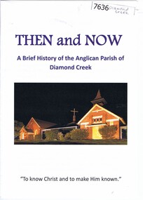
Booklet, Nillumbik Historical Society, Then and now: a brief history of the Anglican Parish of Diamond Creek, 22/10/2019
A history of the Anglican Parish of Diamond Creek, prepared for the Yarra Plenty Regional Library's "Diamond Valley History Tour 2019". The Diamond Creek parish includes St John's Diamond Creek, St Michael's Yarrambat and St Katherine's St Helena.Booklet, 8 pages, text and colour illus.diamond valley, yarra plenty regional library, anglican parish of diamond creek, st john's diamond creek, st katherine's st helena, st michael's yarrambat -
 Linton and District Historical Society Inc
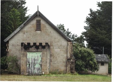
Photograph, Former Church of England Parish Hall, Linton, 2014
The Church of England Parish Hall in Linton was built in 1909-1910, using what was at the time an innovative building technique - concrete blocks with no frame. The Parish Hall was used for countless functions and activities in Linton until about 1989, after which it was considered unsafe to use.Colour photograph showing a building made from concrete blocks. The entry porch has a wooden door with six large hinges. The building is in a somewhat dilapidated condition.parish hall linton, st paul's church of england linton -
 Whitehorse Historical Society Inc.
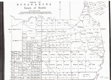
Document, Plan of Parish of Nunawading, 01/05/1864
Copy of plan of Parish of NunawadingCopy of plan of Parish of Nunawading, County of Bourke, lithographed at the Office of Lands and Survey, Melbourne, 13th May, 1864 showing boundaries of Koonung, Mullum Mullum and Dandenong Creeks.Copy of plan of Parish of Nunawadingland subdivision, parish of nunawading, county of bourke, elgars special survey, koonung creek, mullum mullum creek, dandenong creek -
 Orbost & District Historical Society
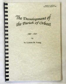
book, Young, Sister Lynette, The Development of the Parish of Orbost, November 1980
Sister Lynette Young was born in Orbost and lived there all her life until 18 when she went to Teachers’ College in Melbourne. This study was produced for partial fulfillment of the requirements of Church History 111 in the degree of Bachelor of Theology in the Melbourne College of Divinity at the affiliated teaching institution, Catholic Theological College in November 1980.This is a local history book written by a local author. It is a useful research tool.A 65 pp spiral bound book with a pale green cover. It is titled The Development of the Parish of Orbost 1887-1937. The title is in black. The book was written by Sister Lynette M. Young.Autographed by Sister Lynette Young.church-history-catholic orbost-history catholic-theological-college -
 Ringwood and District Historical Society
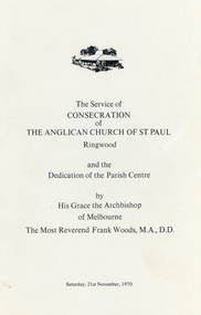
Booklet, Eight-page order of service - The Service of Consecration of the Anglican Church of St.Paul Ringwood and the Dedication of the Parish Centre by His Grace the Archbishop of Melbourne, The Most Reverend Frank Woods, MA, D.D, Saturday 21-Nov-1970
The Service of Consecration of the Anglican Church of St.Paul Ringwood and the Dedication of the Parish Centre by His Grace the Archbishop of Melbourne, The Most Reverend Frank Woods, MA, D.D. +Additional Keywords: Woods, Frank -
 Ringwood and District Historical Society
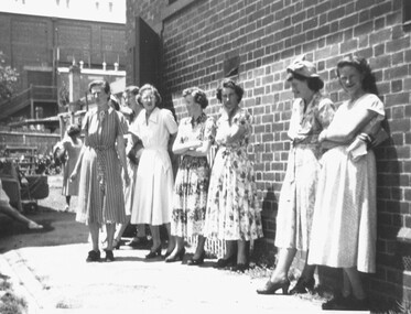
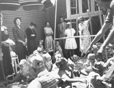
Photograph, 1950 - Parish Hall Xmas Party, Church of England, Ringwood Street, Ringwood. Left to right: Mrs. Radok, Mrs. McWilliam, Mrs. Win Leslie, Mrs. Jess Anderson, (unknown), and Mrs. Enid Durston
Typed below photograph, "1950 - Parish Hall Xmas Party. Mrs. Radok, Mrs. McWilliam, Mrs. Win Leslie, Mrs. Jess Anderson, ??, Mrs. Enid Durston". -
 Whitehorse Historical Society Inc.
Newspaper - Newsletter, St John's, Mitcham newsletter, 40th anniversary of the Parish, 1992
5 copies of the Newsletter for St John's, Mitcham Jan, Feb 1992, features 40th anniversary of St John's Parish also manuscript description of Mass for pioneers buried in the Air Hill Burial Ground.st johns catholic church, mitcham, air hill burying ground -
Whitehorse Historical Society Inc.
Pamphlet - Newsletter, The Parish Messenger, 1920-1957
Anglican parish newsletter for Vermont, Bayswater and Wantirna (and Forest Hill from Nov. 1928).Anglican parish newsletter for Vermont, Bayswater and Wantirna (and Forest Hill from Nov. 1928). Monthly. Holdings: No.1 Dec. 1920 - No 210 Jun 1949, No. 235 Dec. 1951 - No. 300 Nov. 1957Anglican parish newsletter for Vermont, Bayswater and Wantirna (and Forest Hill from Nov. 1928).st lukes anglican church vermont, st stephens anglican church bayswater, st johns anglican church wantirna, st marks anglican church forest hill -
 Kew Historical Society Inc
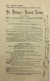
Pamphlet - Document, St Hilary's Anglican Church, St Hilary's Parish Notes, No.70., March 1919, 1919
St Hilary's Anglican Church in Rowland Street, Kew was established in 1888 on land granted to the congregation by the Dumaresq family.The Parish Notes are historically interesting as they outline the various ways in which the Influenza Epidemic of 1919 had an impact on local communities. St Hilary's Church of England Parish Notes from 1919, which includes among other items of interest states that because of the risks of contagion during the influenza epidemic, parishioners are required to worship outside. Written note on front page signed by the Rev Charles H Barnes and dated 16/3/19.st hilary's church of england - kew (vic), churches - kew (vic), influenza epidemic 1919 - kew (vic) -
 Kew Historical Society Inc
Plan - Framed Subdivision Plan (copy), F Price, Plan of Mr William Derrick's Land, Kew being Subdivision of Part of Section 86, Parish of Boroondara, County of Bourke, 1872, 1872
William Derrick was an early landowner in Kew, and with James Venn Morgan and James Dannock the purchaser of the parcel of land bounded by Cotham Road, High Street and Mary Street. Derrick Street in Kew is named after him.Map mounted under perspex. ‘Plan of Mr Willia Derrick's Land, Kew being Subdivision of Part of Section 86, Parish of Boroondara, County of Bourke’. This is a copy of the plan held in the State Library of Victoria.kew subdivision plan, john derrick, subdivision plans -- kew (vic.) -
 Ringwood and District Historical Society
Photograph, 1950 - Parish Hall Xmas Party, Church of England, Ringwood Street, Ringwood. Attendees included Mrs. J. Mason (partly obscured), Mrs. Gray, Mrs. McCrae Snr., Mr. and Mrs. G. Williams
Typed below photograph, "1950 - Parish Hall Xmas Party. Just seen Mrs. J. Mason, Mrs. Gray, Mrs. McCrae Snr., Mr. and Mrs. G. Williams". -
Stawell Historical Society Inc
Map, Borough of Stawell Parish of Stawell and Illawarra 10/06/1903, 10/06/1903
Department of Lands and Survey Map of Stawell with marked roads, allotments, physical landmarks. Found in Storage at ANZ Bank when the old archive was being cleaned out. Also shows Surveyed but unused roads. Showed where customers lived in StawellPholtolithograph Map - Paper on canvas backingBorough of Stawell. Parish of Stawell and Illawarra. County of Borong. Scale 8 Chains to 1 Inch. Scale 16 Chains to 1 Inch. Red Ink Writing, Purple and Blue.town -
Lakes Entrance Historical Society
Book, Campbell Kenneth W, 100 Years of Saints and Sinners The Centenary History of the Anglican Parish of Bruthen in East Gippsland, 1992
A centenary history of St Matthews Anglican Parish of Bruthen,Victoria which includes history and development of the region, establishment of the Church, priests and lay readers, and the other communities served, ie Sarsfield, Wiseleigh, Mossiface, Tamboreligion, township -
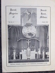 Ballarat Diocesan Historical Commission
Magazine, Sacred Heart Parish Mildura Magazine
This local parish magazine was published from 1960 - 1971 and was an imporrtant communication link for the Catholic people across the Mildura, Sunraysia district in Victoria. -
Whitehorse Historical Society Inc.
Map, Map, Parish of Nunawading, 1850's
A basic map of the Parish of Nunawading to which additions have been made. Scale 70 chains:3.5 inchesA basic map of the Parish of Nunawading to which additions have been made. Scale 70 chains:3.5 inchesmaps, parish of nunawading -
Glenelg Shire Council Cultural Collection
Newspaper - Newsletter - Church of England Parish news, PARISH NEWS, Aug-62
Portland Church of England Parish News, periodical. Eight pages, white semi-gloss paper, black print. 3/- per annum. Front page photo of Missions to Seamen building, accompanying article re opening of Flying Angel Club. -
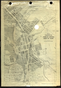 Federation University Historical Collection
Plan, Creswick, Parish of Creswick, County of Talbot, 1928, 1928
Parish Plan of Creswick showing Slaty Creek, Old Gold Workings, Police Reserve, Railway Station, Public Gardens, Sawpit Gully, Hospital Reserve, Nigh Soil Depot, Eureka Terracotta Tile COmpany, Creswick Creek, Forest COmmission, Roycroft's Racecreswick, eureka terracotta tile co, parish plan -
 Bacchus Marsh & District Historical Society
Map, Mooradoranook Parish Map, County of Grant
A single page paper map showing the map for the Parish of Mooradanook in the County of Grant. Cadastral map showing land ownership. The map is pasted into a bound volume containing 76 maps or plans in total. High resolution digital image stored on BMDHS computer network. Photo lithographed at the Department of Lands and Survey Melbourne by T. F. McGauran, 27.11.06mooradoranook parish maps, mooradoranook parish plan, bacchus marsh region parish plans -
 Bacchus Marsh & District Historical Society
Map, Mouyong Parish Map, County of Grant
A single page paper map showing the map for the Parish of Mouyong in the County of Grant. Cadastral map showing land ownership. The map is pasted into a bound volume containing 76 maps or plans in total. High resolution digital image stored on BMDHS computer network. Photo lithographed at the Department of Lands and Survey Melbourne by T. F. McGauran, 9. 4. 07mouyong parish plan, mouyong parish maps, bacchus marsh region parish plans -
Whitehorse Historical Society Inc.
Map, Parish of Nunawading, 1927
Map of the Parish together with part of the Borough of Box Hill.Map of the Parish together with part of the Borough of Box Hill. Includes names of lease or license holders, sizes of leases and in some areas dates of leases. Roads, railway and stations marked. Original survey by W.J.Busocon, 1915. Manuscript note: 15.2.1927 Verified Dept. Lands and Survey.Map of the Parish together with part of the Borough of Box Hill. maps, parish of nunawading, borough of box hill -
 Greensborough Historical Society
Map - Map (Copy), C. Hodgkinson, District Surveyor et al, Parish of Yan Yean 1856: Village site during construction of the Yan Yean Reservoir, 1978
Copy of map part Sec. 13, Parish of Yan Yean 1856, Map 3, Village site... Scale: 8 chains to 1 inch. Drawn by C. Hodgkinson, District Surveyor, redrawn by A. R. Blair 1978. 1 p. photocopy of map. yan yean reservoir, yan yean -
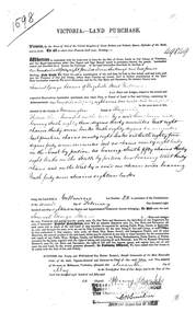 Ringwood and District Historical Society
Land Purchase Document, Land Purchase for Samuel George Isaacs of Elizabeth Street, Melbourne for 148 acres, 2 roods and 9 perches in County of Mornington Parish of Ringwood - 1858, Feb-1858
1598 laminated copy on cardboard of Victoria - Land Purchase for Samuel George Isaacs of Elizabeth Street, Melbourne for 148 acres, 2 roods and 9 perches in County of Mornington Parish of Ringwood for the sum of 148 pounds 11 shillings and two pence. +Additional Keywords: Isaacs, Samuel Georgeas above -
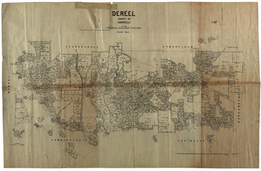 Federation University Historical Collection
Plan, Dereel Parish Plan, 1928, 16/07/1928
Parish Plan of Dereel showing crown allotments, dimensions, crown grantees, dates of grant. Scale 1:31,680 WGS 84 Centroid 37 degrees 48 feet 33 inches S 143 degrees 41 feet 46 inches S NS: 6.3km EW: 15.2kmdereel, parish plan, p. mclachlan, rifle range, j. bower, dereel lagoon, t. mellington, j. mcdonald -
 Bacchus Marsh & District Historical Society
Map, Plan of Survey of Part of Crown Allotment 9, Parish of Korkuperrimul, 1890
This map documents a transfer of an allotment of land in Clarke Street Bacchus Marsh in 1890. Clarke Street is located on the eastern side of Bacchus Marsh not far from Main Street and Crook Street. It is now known as Candeloro Street. The map indicates J. Booth as the owner of the land and H. Simpson as the occupier. Next to this allotment is a an allotment of land owned by J. Elmore,Single page map showing Crown allotment 9, Parish of Korkuperrimul, County of Bourke. Scale 100 feet to inch. Part of a set of maps which are pasted into a bound volume containing 76 maps or plans in total. High resolution digital image stored on BMDHS computer network. At bottom of map: I hereby certify that I have made this survey expressly for the purpose of an application under the Transfer of Land Statute that this plan is correct. Barry B???, Lic. Surveyor, 16.10.90bacchus marsh victoria maps, clarke street bacchus marsh maps -
 Bacchus Marsh & District Historical Society
Map, Limestone Reserve Parish of Merrimu 1888
Limestone deposits in the Coimadai area 10 kilometers north of Ballarat were first worked in the 1850s. The area was quarried for limestone for many years by various people and companies. The surveyor's name who produced this plan is inscribed on the map and below this is the name P. L. Alkemade, who presumably paid for the map to be produced. In 1886 Petrus Alkemade in partnership with Matthew Egan established the Alkemade Hydraulic Lime and Cement Company. The Alkemade family were involved in the limestone industry over several generations at Coimadai.Single page map showing part of the Limestone reserve near Coimadai in the Parish of Merrimu. Scale 4 chains to 1 inch. Part of a set of maps which are pasted into a bound volume containing 76 maps or plans in total. High resolution digital image stored on BMDHS computer network. Copy of plan surveyed by Mr. G? [illegible] an authorised surveyor on 17th July 1888. P. L. Alkemadebacchus marsh victoria maps, lime kilns coimadai, limestone, coimadai victoria maps, alkemade family coimadai -
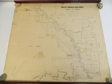 Kiewa Valley Historical Society
Map - Kiewa Valley, Parish Map of Mullindolingong, 12/10/1906
The map shows the names of people living in the parish of Mullindolingong in 1906. These people had leases or licences giving the reader an insight into the number of people in the area and an understanding of the size of their holdings. Infrastructure is also given including shops, schools, churches etc. Presumably it was used by the Ryder family.This map gives an historical insight into the parish of Mullindolingong as it names people and the infrastructure - roads, buildings etc. as it was in 1906. This enables the reader to compare the area at the time with other times and other places and to have an understanding of the early settlers in the area.This is a very old paper or parchment map with wooden rods top and bottom. The top rod has ribbons attached to enable hanging. The map shows the current leases and licences and when they were held by during this period, circa 1906.Mullindolingong County of Bogong. This plan has been prepared by The Most Reliable Data in the Possession of the Department up to the date of its Compilation. Information respecting Leases or Licences which await Final Completion is not recorded.parish of mullindolingong map; ryder family; early settlers; -
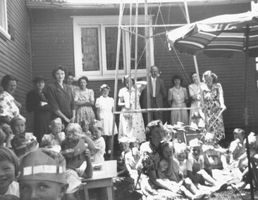 Ringwood and District Historical Society
Photograph, 1950 - Parish Hall Xmas Party, Church of England, Ringwood Street, Ringwood. Mrs. Caughey, Mrs. McCrae Senr. Mr. and Mrs. G. Williams, Mr. John McCrae, Mrs. M. McCall, Mrs. McWilliam, Mrs. Dedman, Mrs. Win Leslie, Director
Typed below photograph, "1950 - Parish Hall Xmas Party. Mrs. Caughey, Mrs. McCrae Senr. Mr. and Mrs. G. Williams, Mr. John McCrae, Mrs. M. McCall, Mrs. McWilliam, Mrs. Dedman, Mrs. Win Leslie, Director". -
 Greensborough Historical Society
Poster - Planning Document, Shire of Diamond Valley et al, Subdivision Plan # 1044 - Parish of Nillumbik, County Bourke, Crown Allotment B Section 12, Eltham North, 1981-1987
Subdivision Plan # 1044 - Parish of Nillumbik, County Bourke, Crown Allotment B Section 12, Eltham North. This subdivision plan includes Weidlich Road and St Clems Street. The developer for this subdivision is Taunton Developments and the Surveyors are Fisher Cleeland Turner & Dwyer Vic, Surveyors and Engineers.An example of hard copy subdivision plans from the Greensborough area. Mainly from the Shire of Diamond Valley era (1964-1994).Plan (single sided) mounted on heavy card. Stamped and handwritten Council permissions, dates and other details. subdivision plans, shire of diamond valley, taunton developments -
Ringwood and District Historical Society
Newspaper cuttings, The Ringwood Mail, Three newspaper clippings relating to 'The opening of the Ringwood Coolstores on 17th March, 1911' published in 'The Mail' 3rd December 1959. 1. Early History of the Parish of Ringwood by J.K. McCaskill J.P. 2. as above, continued from previous page. 3. Two pictures of the Ringwood Coolstores, 1911, 3-Dec-59
Three newspaper clippings relating to 'The opening of the Ringwood Coolstores on 17th March, 1911' published in 'The Mail' 3rd December 1959.; 3181.1 Early History if the Parish of Ringwood by J.K. McCaskill J.P.; 3181.2 As above, continued from previous page; 3181.3 Two pictures of the Ringwood Coolstores, 1911. +Additional Keywords: McCaskill, J.K. -
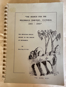 City of Moorabbin Historical Society (Operating the Box Cottage Museum)
Book - Family History, Joy, Shirley, The Search For The Beaumaris Cemetery Victoria 1855--1865 : The Wesleyan burial ground in the Parish of Moorabbin, 1995
A history of the Beaumaris Cemetery and who is buried there and the subdivision of the Wesleyan church.vii, 92 leaves : ill., facsims., 1 plan, ports. A large spiral bound book with a soft cover detailing the early burial sites in the Beaumaris Cemetery.The front cover is white with a drawn picture of three graves and a girl in a long dress standing beside them also on the cover is the The Wesleyan Burial Ground in the Parish of Moorabbin.non-fictionA history of the Beaumaris Cemetery and who is buried there and the subdivision of the Wesleyan church.beaumaris, cheltenham, graves, burials, cemetery, registrar's records, subdivision, wesleyan.