Showing 9790 items matching " plenty road"
-
 City of Whittlesea
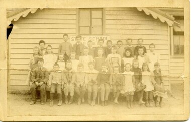
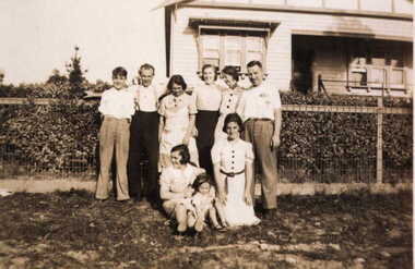
Photograph - Photographs - Schools, Mernda State School No 488
... Plenty Road, Mernda, Victoria ...Digital copy of school group photograph Mernda State School No 488 -
 City of Whittlesea
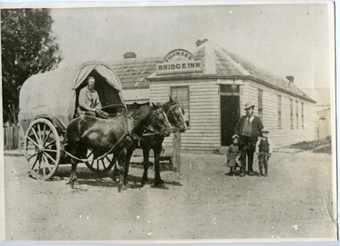
Photograph - Photographs - Buildings, Bridge Inn Hotel Mernda
... Plenty Road, Mernda, Victoria ...Moses Thomas standing with 2 children, Walter Thomas in wagon at the Bridge Inn Hotel Mernda possibly late 1860s early 1870s -
 The 5th/6th Battalion Royal Victoria Regiment Historical Collection
Award - Presentation Plaque, 5/6 R.V.R. SPT COY WARK V.C. CLUB BEST J.N.C.O. AWARD
... 131 Plenty Road, Preston, Victoria, Australia ...Presented to the best JNCO in Support Company 5/6RVR by members of the Wark VC club until 2010This item provides a list of names of active members of Support Company and the Wark VC Club between the years of 1992 and 2010- intermittently Varnished MDF plaque with black and brass plates with incriptions of the awards title, presenter and recipients affixed. There are 5 empty places.5/6 R.V.R. SPT COY WARK V.C. CLUB BEST J.N.C.O. AWARD DONATED BY WOS. E. SCHLEGEL -1992- C. BYVOET -1995- LCPL S. GALLAGHER -1996- CPL CADOGAN-COWPER D. -2009- CPL N. HILL -2010- CPL B.SHAWYER support company -
 Eltham District Historical Society Inc
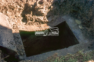
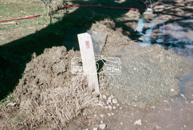
Slide, Pit located on the east side of Bonds Road, Lower Plenty, 18 July 1972, 1972
... Pit located on the east side of Bonds Road, Lower Plenty... in Bonds Road, Lower Plenty outside the Martin property opposite... in Bonds Road, Lower Plenty outside the Martin property opposite ...Water drainage work undertaken by Eltham Shire Council in Bonds Road, Lower Plenty outside the Martin property opposite Montpelier Drive, July 1972 35 mm colour positive transparency Mount - Agfacolor Service (Blue)Bonds Road (Martin property) 12.10 pm 18.7.72bonds road, drainage works, eltham shire council, infrastructure, lower plenty, martin property, montpelier drive -
 Eltham District Historical Society Inc
Slide, Looking westerly into Martin's property across Bonds Road, Lower Plenty, 18 July 1972, 1972
... Looking westerly into Martin's property across Bonds Road... in Bonds Road, Lower Plenty outside the Martin property opposite... in Bonds Road, Lower Plenty outside the Martin property opposite ...Water drainage work undertaken by Eltham Shire Council in Bonds Road, Lower Plenty outside the Martin property opposite Montpelier Drive, July 1972 35 mm colour positive transparency Mount - Agfacolor Service (Blue)Bonds Road (Martin property) 12.10 pm 18.7.72bonds road, drainage works, eltham shire council, infrastructure, lower plenty, martin property, montpelier drive -
 Eltham District Historical Society Inc
Slide, View of Martin's house indicating its relationship to the gully, Bonds Road, Lower Plenty, 18 July 1972, 1972
... gully, Bonds Road, Lower Plenty, 18 July 1972... in Bonds Road, Lower Plenty outside the Martin property opposite... in Bonds Road, Lower Plenty outside the Martin property opposite ...Water drainage work undertaken by Eltham Shire Council in Bonds Road, Lower Plenty outside the Martin property opposite Montpelier Drive, July 1972 35 mm colour positive transparency Mount - Agfacolor Service (Blue)Bonds Road (Martin property) 12.10 pm 18.7.72bonds road, drainage works, eltham shire council, infrastructure, lower plenty, martin property, montpelier drive -
 Greensborough Historical Society
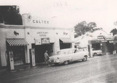
Photograph - Digital image, Main Road Lower Plenty Garage 1962, 1962_
... Main Road Lower Plenty Garage 1962...main road lower plenty...Caltex garage, Main Road Lower Plenty in 1962. Photographs... Plenty Lower Plenty melbourne Caltex garage, Main Road Lower ...Caltex garage, Main Road Lower Plenty in 1962. Photographs from the collection of Peter Blackbourn, a descendant of the Chapman Stock family. Annotations to photos by Peter Blackbourn.Digital copy of black and white photograph.Date (1962) written on front of photograph.peter blackbourn, main road lower plenty, caltex garage lower plenty 1962 -
 Greensborough Historical Society
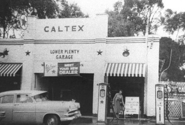
Photograph - Digital Image, Lower Plenty Garage, 1950s
... main road lower plenty...Lower Plenty Garage (a Caltex service station) on Main Road... service station) on Main Road Lower Plenty (previously Old Eltham ...Lower Plenty Garage (a Caltex service station) on Main Road Lower Plenty (previously Old Eltham Road) in the 1950s. This photograph shows the garage with petrol pumps out front and a Caltex sign above door.Digital copy of black and white photographlower plenty, lower plenty garage, main road lower plenty, old eltham road lower plenty, caltex garage lower plenty -
 Greensborough Historical Society
Photograph - Digital image, Main Road Lower Plenty 1928, 1928_
... Main Road Lower Plenty 1928...122 main road lower plenty...122 Main Road Lower Plenty, built by Stan Barnett 1928... Plenty Lower Plenty melbourne 122 Main Road Lower Plenty, built ...122 Main Road Lower Plenty, built by Stan Barnett 1928. Photographs from the collection of Peter Blackbourn, a descendant of the Chapman Stock family. Annotations to photos by Peter Blackbourn.Digital copy of black and white photograph.peter blackbourn, stan barnett, 122 main road lower plenty -
 Eltham District Historical Society Inc
Slide, Pit on east side of Bonds Road, Lower Plenty, 18 July 1972, 1972
... Pit on east side of Bonds Road, Lower Plenty, 18 July 1972... in Bonds Road, Lower Plenty outside the Martin property opposite... in Bonds Road, Lower Plenty outside the Martin property opposite ...Water drainage work undertaken by Eltham Shire Council in Bonds Road, Lower Plenty outside the Martin property opposite Montpelier Drive, July 1972 Note rubbish excavated from pit.35 mm colour positive transparency Mount - Agfacolor Service (Blue)Bonds Road (Martin property) 12.10 pm 18.7.72bonds road, drainage works, eltham shire council, infrastructure, lower plenty, martin property, montpelier drive -
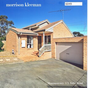 Greensborough Historical Society
Advertising Leaflet, 1/3 Airlie Road Lower Plenty, 24/09/2018
... 1/3 Airlie Road Lower Plenty...1/3 Airlie Road Lower Plenty. 2 bedroom unit. Sold 24/09... Plenty Lower Plenty melbourne 1/3 Airlie Road Lower Plenty. 2 ...1/3 Airlie Road Lower Plenty. 2 bedroom unit. Sold 24/09/2018 for $610,000. Previous sales: September 2015 for $452,000, and May 2007 for $269,750. Built 1990.Real Estate advertising leaflet,1 sheet folded into 4 pages, printed in colour both sides. 2 copies.airlie road montmorency -
![Photograph - Digital image, 122 Main Road Lower Plenty [Caroline Barnett and son Alfred], 1945c](/media/collectors/4f729f5697f83e03086015b8/items/54bec7c92162f1159cba0945/item-media/54bec7f82162f1159cba0dcb/item-fit-380x285.jpg) Greensborough Historical Society
Greensborough Historical SocietyPhotograph - Digital image, 122 Main Road Lower Plenty [Caroline Barnett and son Alfred], 1945c
... 122 Main Road Lower Plenty [Caroline Barnett and son Alfred]...122 main road lower plenty...122 Main Road Lower Plenty; looking toward the Primary... Plenty Lower Plenty melbourne 122 Main Road Lower Plenty; looking ...122 Main Road Lower Plenty; looking toward the Primary School with Caroline Barnett and son Alfred. Photographs from the collection of Peter Blackbourn, a descendant of the Chapman Stock family. Annotations to photos by Peter Blackbourn.Digital copy of black and white photograph.peter blackbourn, 122 main road lower plenty, caroline barnett -
 Eltham District Historical Society Inc
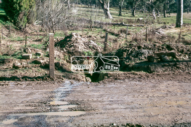
Slide, Southern alignment of Montpelier Drive looking north up Bonds Road, Lower Plenty, 18 July 1972, 1972
... Bonds Road, Lower Plenty, 18 July 1972... in Bonds Road, Lower Plenty outside the Martin property opposite... in Bonds Road, Lower Plenty outside the Martin property opposite ...Water drainage work undertaken by Eltham Shire Council in Bonds Road, Lower Plenty outside the Martin property opposite Montpelier Drive, July 1972 The water is not able to enter the pit on the northern side of Montpelier. It then flows along and across Bonds Road.35 mm colour positive transparency Mount - Agfacolor Service (Blue)Bonds Road (Martin property) 12.10 pm 18.7.72bonds road, drainage works, eltham shire council, infrastructure, lower plenty, martin property, montpelier drive -
 Eltham District Historical Society Inc
Slide, Southern alignment of Montpelier Drive looking north up Bonds Road, Lower Plenty, 18 July 1972, 1972
... Bonds Road, Lower Plenty, 18 July 1972... in Bonds Road, Lower Plenty outside the Martin property opposite... in Bonds Road, Lower Plenty outside the Martin property opposite ...Water drainage work undertaken by Eltham Shire Council in Bonds Road, Lower Plenty outside the Martin property opposite Montpelier Drive, July 1972 The water is not able to enter the pit on the northern side of Montpelier. It then flows along and across Bonds Road.35 mm colour positive transparency Mount - Agfacolor Service (Blue)Bonds Road (Martin property) 12.10 pm 18.7.72bonds road, drainage works, eltham shire council, infrastructure, lower plenty, martin property, montpelier drive -
 Greensborough Historical Society
Photograph - Digital image, Barnett family at 122 Main Road Lower Plenty, 1930c
... Barnett family at 122 Main Road Lower Plenty....122 main road lower plenty...The Barnett family at 122 Main Road Lower Plenty. (Left... Plenty Lower Plenty melbourne The Barnett family at 122 Main Road ...The Barnett family at 122 Main Road Lower Plenty. (Left to right, standing: Mick, Bill, Elsie, Ivy, Amile,Les,(Kneeling) Marg Barnett, Margaret Blackbourn, Margaret Barnett, Photographs from the collection of Peter Blackbourn, a descendant of the Chapman Stock family. Annotations to photos by Peter Blackbourn.Digital copy of black and white photograph.peter blackbourn, barnett family, 122 main road lower plenty -
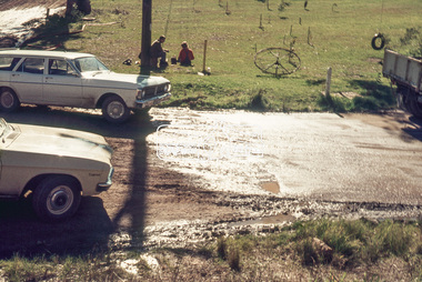
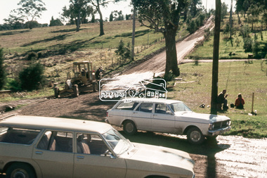
 Eltham District Historical Society Inc
Slide, Bonds Road, Lower Plenty, Mar. 1981
... Bonds Road, Lower Plenty... on Bonds Road, Lower Plenty, the section connecting Old Eltham Road... on Bonds Road, Lower Plenty, the section connecting Old Eltham Road ...One of a series of images of road infrastructure focussed on Bonds Road, Lower Plenty, the section connecting Old Eltham Road with Rosehill Road, taken by Eltham Shire Council Planning and Engineering officers. They provide perspective of the changes in housing styles and road development that began sweeping in from the mid 1970s with increasing urbanisation of what was once more outlying suburbs and regions. All images have been identified with GPS35 mm colour positive transparency (1 of 13) Mount - Kodak Kodachrome CardProcessed Mar 1981infrastructure, roads, bonds road, lower plenty -
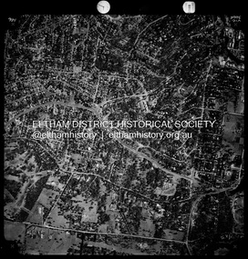
 Eltham District Historical Society Inc
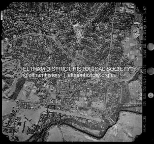
Photograph - Aerial Photograph, Landata, Montmorency / Lower Plenty, Mar. 1987
... Centred on 354-356 Main Road, Lower Plenty bounded...Centred on 354-356 Main Road, Lower Plenty bounded ...Centred on 354-356 Main Road, Lower Plenty bounded by Rattray Road, Montmorency to north, Yarra River to south, Falkiner Street, Eltham to east and Lower Plenty shops to west. Historic Aerial Imagery Source: Landata.vic.gov.au Aerial Photo Details: Project No :1716 Project : WESTERN PORT FORESHORES Run : 16 Frame : 132 Date : 03/1987 Film Type : B/W Camera : RC10 Flying Height : 5600 Scale : 10000 Film Number : 4102 GDA2020 : 37°43'51"S, 145°07'38"E MGA2020 : 334968, 5822406 (55) Melways : 21 E9 (ed. 42)aerial photo, lower plenty, main road, montmorency, phoebe mason collection, eltham, eltham lower park, falkiner street, lower plenty shops, main road eltham, rattray road, yarra river -
 Eltham District Historical Society Inc
Photograph - Aerial Photograph, Landata, Montmorency / Lower Plenty, Nov. 1975
... Centred on 328 Main Road, Lower Plenty bounded by Rattray...Centred on 328 Main Road, Lower Plenty bounded by Rattray ...Centred on 328 Main Road, Lower Plenty bounded by Rattray Road, Montmorency to north, Rosehill Road to south, Falkiner Street to east and Lower Plenty shops to west. Historic Aerial Imagery Source: Landata.vic.gov.au Aerial Photo Details: Project No :1243 Project : (ALSO A.P. 1227) Run : 24A Frame : 146 Date : 11/1975 Film Type : B/W Camera : RC8 Flying Height : 5000 Scale : 10000 Film Number : 2722 GDA2020 : 37°43'40"S, 145°07'32"E MGA2020 : 334820, 5822743 (55) Melways : 21 D8 (ed. 42)aerial photo, lower plenty, main road, montmorency, phoebe mason collection, eltham lower park, falkiner street, lower plenty shops, rattray road, rosehill road -
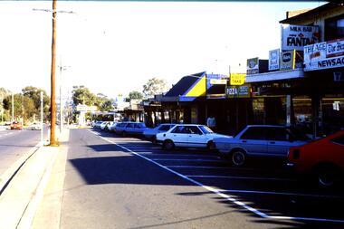 Greensborough Historical Society
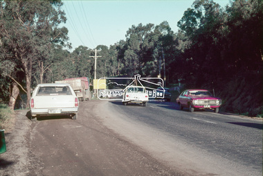
Slide - Photograph, John Ramsdale, Main Road shops, Lower Plenty: Slide 70, 1990s
... Main Road shops, Lower Plenty: Slide 70...main road lower plenty...Photograph shows a shopping centre - Main Road Lower Plenty... - Main Road Lower Plenty Part of the John Ramsdale collection ...Photograph shows a shopping centre - Main Road Lower PlentyPart of the John Ramsdale collection of slides and audio visual material.Colour photograph scanned from slide.No maker's marks. No caption on slide.lower plenty, main road lower plenty -
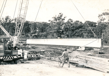 Eltham District Historical Society Inc
Photograph, Construction of Lower Plenty Bridge, Main Road, c.August 1966, 1966
... Construction of Lower Plenty Bridge, Main Road, c.August... melbourne plenty river bridge construction main road lower plenty ...Black and white photograph of crane lowering concrete girder into placeplenty river, bridge construction, main road, lower plenty, bridges -
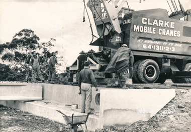 Eltham District Historical Society Inc
Photograph, Construction of Lower Plenty Bridge, Main Road, c.August 1966, 1966
... Construction of Lower Plenty Bridge, Main Road, c.August... melbourne bridges bridge construction main road lower plenty plenty ...Black and white photograph of construction of northern Lower Plenty Bridge 1969bridges, bridge construction, main road, lower plenty, plenty river, cranes -
 Eltham District Historical Society Inc
Photograph, Russell Yeoman, Para Road, c.1969, 1969c
... Looking north from behind the Lower Plenty shops at Main...Para Road, Lower Plenty, Victoria, Australia... Road and Para Road. streets lower plenty para road Russell ...Looking north from behind the Lower Plenty shops at Main Road and Para Road.Digital file only; created from original colour positive slide transparencystreets, lower plenty, para road, russell yeoman collection -
 Eltham District Historical Society Inc
Slide, Main Road, Lower Plenty, 25 Jul 1973
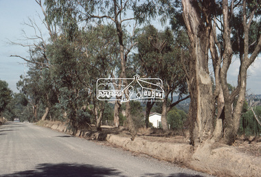
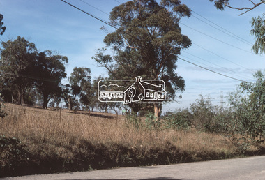
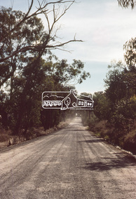
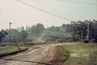
... Main Road, Lower Plenty... at Bolton Street. Main Road, Lower Plenty underwent substantial... at Bolton Street. Main Road, Lower Plenty underwent substantial ...This section of Main Road was known by locals as the "Windy Mile" due to its many little wists and turns. It was also the setting for Billy Cart derbies held on special occassions such as the Eltham Easter Gymkhana at Eltham Lower Park. Contestants would line up and race each other down the hill to the finish line at Bolton Street. Main Road, Lower Plenty underwent substantial changes when it was duplicated with the road becoming two lanes each way and split level due to the cross gradient. This particular section running down the hill from Panorama Avenue to Bolton Street with its twists and turns had many of them straightened out during the road widening constuction work.35 mm colour positive transparency Mount - Agfacolor Service (Blue)main road, infrastructure, lower plenty, roads, windy mile -
 Melbourne Tram Museum
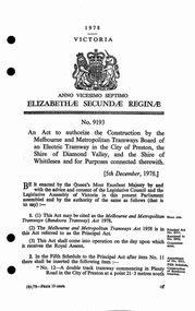
Legal record, Victorian Government, "Act of Parliament", 1/12/1978 12:00:00 AM
... and the Shire of Diamond Valley and the Shire of Whittlesea in Plenty... of Whittlesea in Plenty Road, to Settlement Road. Dated 5/12/1978 ...Act of the Victorian Parliament to authorize the construction by the MMTB of an electric tramway in the City of Preston and the Shire of Diamond Valley and the Shire of Whittlesea in Plenty Road, to Settlement Road. Dated 5/12/1978trams, tramways, mmtb, acts of parliament, new tramway, east preston, plenty rd, construction