Showing 192 items
matching property rate
-
 Kew Historical Society Inc
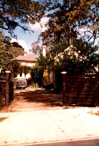
Photograph - 'Butleigh Wooton', 867 Glenferrie Road, John T Collins, 1979
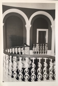
in 1882 Thomas Maidment paid the Society of Jesus £5,750 for nine allotments along Barkly Road (now Glenferrie Road). Maidment, who had arrived in Australia from the Glastonbury district in England in 1858, owned and managed a number of sheep stations in Victoria and subsequently became an '... eminently respectable ...' member of District society. In 1883 the Rate Books list Maidment's land in Barkly Road as the 'Buxton Hill Estate' and it was given an N.A.V. of £90, while in the following year his property attracted an N.A.V. of £160, suggesting that substantial improvements were taking place. Maidment's two-storey mansion, named 'Butleigh Wooton' after his birth-place in England, was completed in 1885 and was given an initial N.A.V. of £420. While Maidrnent is recorded as the owner of the building until at least 1896, Jane Maidment, his wife, continued the family ownership of the twenty-six roomed house with its extensive grounds until at least 1910. (Sanderson P. City of Kew Urban Conservation Study Vol 2)Butleigh Wooton is a substantial two storeyed house built in the Italianate style common in the 1880s. Its walls are rendered and it has limited applied decoration that includes brackets to the eaves line and engaged ionic columns under a broken pediment over the front entrance. The bowed window unit is of particular distinction and is not at all typical of this type of building. This interior by John T Collins is a view of the staircase from the first floor landing. (Sanderson P. City of Kew Urban Conservation Study Vol 2)Reverse: "JOHN COLLINS / 11 Anderson Road / Hawthorn East, 3123 / Film 395 Exposure 21A / Kew / Butleigh Wooton / Railing at head of stairs / 8-4-79thomas maidment, butleigh wooton, 867 glenferrie road -- kew (vic.), john t collins -
 Kew Historical Society Inc
Photograph - 'Butleigh Wooton', 867 Glenferrie Road, John T Collins, 1979
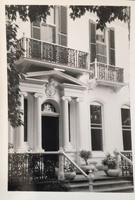
in 1882 Thomas Maidment paid the Society of Jesus £5,750 for nine allotments along Barkly Road (now Glenferrie Road). Maidment, who had arrived in Australia from the Glastonbury district in England in 1858, owned and managed a number of sheep stations in Victoria and subsequently became an '... eminently respectable ...' member of District society. In 1883 the Rate Books list Maidment's land in Barkly Road as the 'Buxton Hill Estate' and it was given an N.A.V. of £90, while in the following year his property attracted an N.A.V. of £160, suggesting that substantial improvements were taking place. Maidment's two-storey mansion, named 'Butleigh Wooton' after his birth-place in England, was completed in 1885 and was given an initial N.A.V. of £420. While Maidrnent is recorded as the owner of the building until at least 1896, Jane Maidment, his wife, continued the family ownership of the twenty-six roomed house with its extensive grounds until at least 1910. (Sanderson P. City of Kew Urban Conservation Study Vol 2)Butleigh Wooton is a substantial two storeyed house built in the Italianate style common in the 1880s. Its walls are rendered and it has limited applied decoration that includes brackets to the eaves line and engaged ionic columns under a broken pediment over the front entrance. The bowed window unit is of particular distinction and is not at all typical of this type of building. This interior by John T Collins is a view of the staircase from the first floor landing. (Sanderson P. City of Kew Urban Conservation Study Vol 2)Reverse: "JOHN COLLINS / 11 Anderson Road / Hawthorn East, 3123 / Film 395 Exposure 21A / Kew / Butleigh Wooton / Entrance / 8-4-79thomas maidment, butleigh wooton, 867 glenferrie road -- kew (vic.), john t collins -
 Glen Eira City Council History and Heritage Collection
Flyer, The Craftsman Press Pty. Ltd, 1941
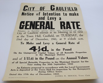
This flyer is entitled "City of Caulfield / Notice of Intention to make and Levy a General Rate" and served to notify residents that the Council of the City of Caulfield intended to "make and levy a General Rate of four and a half pence in the pound on the unimproved Capital Values of all Rateable Properties in the Municipal District and of 1/11.65 in the pound on the Annual Values of all Special Rateable Properties in the Municipal District for the Year ending the 30th September, 1942" at its meeting to be held at the Town Hall of Caulfield on Tuesday 23rd of December, 1941. The flyer bears the name of the Town Clerk, James R. Briggs. The flyer was printed by The Craftsmen Press for City of Caulfield, and is dated 17th December, 1941.Single page flyer printed on buff paper with black ink. Entitled "City of Caulfield / Notice of Intention to make and Levy a General Rate" -
 Glen Eira City Council History and Heritage Collection
Flyer, 1934
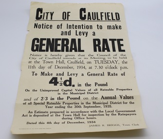
This flyer is entitled "City of Caulfield / Notice of Intention to make and Levy a General Rate" and served to notify residents that the Council of the City of Caulfield intended to "make and levy a General Rate of four and a half pence in the pound on the unimproved Capital Values of all Rateable Properties in the Municipal District and of 2/3 in the pound on the Annual Values of all Special Rateable Properties in the Municipal District for the Year ending the 30th September, 1935" at its meeting to be held at the Town Hall of Caulfield on Tuesday 11th of December, 1934. The flyer bears the name of the Town Clerk, James R. Briggs. The flyer was printed by The Craftsmen Press for City of Caulfield, and is dated 4th December, 1934.Single page flyer printed on buff paper with black ink. Entitled "City of Caulfield / Notice of Intention to make and Levy a General Rate" -
 Surrey Hills Historical Society Collection
Photograph, Rear of Varndean from Willcyrus Street, 1988, 1988
Ref: Alan Holt records - This property has had a number of different names throughout its history. William Cook, a farmer, bought the land it stands on in 1876. In 1882 he was rated for a house (not the current one) on 11 acres. The present house was built in 1885 by John Clark, an auctioneer. In 1888 the Tower Hill estate and the home (Tower Hill Lodge) were auctioned, but the house was not sold. In 1889 the house was purchased by Captain Shepherd. Records show that in 1894 the owners were Mr Thomas and Mrs Hortenzia Howell. They named the house 'Corcovado'. Later they added a study with a corner designed to provide views from the Dandenong Ranges around to Mt Macedon. In 1944 Mr and Mrs Lionel Adams renamed the house 'Varndean'.This is one of the earliest surviving houses in Surrey Hills.A colour photo taken from the street at the rear of a Victorian-style house with ornate chimneys and a slate roof. A parked car is seen in front of the house. The house sits behind a timber fence and is partly hidden by mature shrubs and trees.victorian style, tower hill lodge, corcovado, varndean, tower hill estate, mr william cook, mr john clark, mrs hortenzia howell, mr lionel adams, mrs lionel adams, surrey hills, captain louis shepherd, mr thomas howell -
 Port Fairy Historical Society Museum and Archives
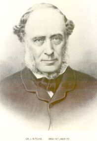
Photograph, Cr J Ritchie Shire of Belfast President1866-67 1869-70
Cr J Ritchie came from Scotland at Hobart in 1833 having been 9 months on the outward journey. he took up land at South Esk and remained there for 6 years.later on advice of the Henry brothers he came to Victoria and after a preliminary inspection of the land charted the brig “William” and with all of his possessions, including 2000 sheep and two servants he arrived in Portland Bay in January 1840 and as he already held a squatting licence No 230 became a settler in the district. he moved along the coast toward Goose Lagoon but due to a drought the water had dried up and forced him to move further eastward to the Upeer Hopkins but the lack of any but brackish water he was forced to return to Aringa. Aringa comprised of 26,000 acres between the Shaw and Moyne Rivers, 640 acres became freehold at one pound and acre with the right to take up leasehold at a low rate according to the number of stock. At Aringa he designed and built his first home part of which still stands today. He married Sarah Elizabeth Davis in 1852 at Weerongurt Station (Mr John Cox’s property). Mrs Ritchie died in 1920. he was elected Shire of Belfast President for the periods of 1866-67 and 1869-70 John had originally chosen to practice law as his vocation in Scotland but abandoned law for the open air life and died at the age of 86 years in 1887 elected Shire of Belfast President for the periods of 1866-67 and 1869-70Black and white portrait photograph Cr J Ritchie 1866-67 1869-70belfast, president, council, portrait, government, shire, municipal, local-government -
 Wonga Park Community Cottage History Group
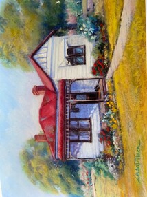
Photograph - Painting, The Hedge, Yarra Road Wonga Park
The Hedge, aka Thomas Knee's house. Thomas Samuel Knee (born c. 1881in Lilydale) married Jane Maggs c. 1912, Thomas Samuel Knee's father Thomas Knee (married to Sarah Hardidge and who it appears was also an orchardist in Yarra Road) was rated for the land as vacant land at the turn of the century (c. 1900) Thomas Samuel Knee rated as owner of vacant land (CA14B of over 20 acres1911-12 and as a house 1912-13, next year CA 14C added making a total of 39 acres. It appears that Thomas Samuel Knee and his wife Jane lived at the property until 1949 when they moved to Montrose. In 1949 it was purchased by Hubert Victor (Vic) Eggleton after they migrated from Banstead in Surrey England. They had four boys Peter (who did a lot of the farming with Gladys), Brian, Michael and Roger. It was mixed farming: lemons, cherries, eggs, chickens and Gladys bred Spaniel dogs too. They had 2 dairy cows and a draft horse. The farm was larger then and was subdivided at a later date. The big dam was added too. the painting of the house was painted by a cousin of the Lusks. Ownership: Thomas Samuel Knee 1912-1949, Eggletons, 1949 - c.1953, then Timms, c. 1953 - early 1970s then Lusks early 1970s to c. 2012. The Lusks built a new house and after that the old house had various tenants. -
 Wonga Park Community Cottage History Group
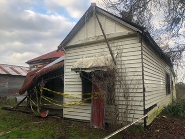
Photograph - Colour, The Hedge (Tom Knee's House) 278 Yarra Road Wonga Park in 2023
The Hedge, aka Thomas Knee's house. Thomas Samuel Knee (born c. 1881in Lilydale) married Jane Maggs c. 1912, Thomas Samuel Knee's father Thomas Knee (married to Sarah Hardidge and who it appears was also an orchardist in Yarra Road) was rated for the land as vacant land at the turn of the century (c. 1900) Thomas Samuel Knee rated as owner of vacant land (CA14B of over 20 acres1911-12 and as a house 1912-13, next year CA 14C added making a total of 39 acres. It appears that Thomas Samuel Knee and his wife Jane lived at the property until 1949 when they moved to Montrose. In 1949 it was purchased by Hubert Victor (Vic) Eggleton after they migrated from Banstead in Surrey England. They had four boys Peter (who did a lot of the farming with Gladys), Brian, Michael and Roger. It was mixed farming: lemons, cherries, eggs, chickens and Gladys bred Spaniel dogs too. They had 2 dairy cows and a draft horse. The farm was larger then and was subdivided at a later date. The big dam was added too. the painting of the house was painted by a cousin of the Lusks. Ownership: Thomas Samuel Knee 1912-1949, Eggletons, 1949 - c.1953, then Timms, c. 1953 - early 1970s then Lusks early 1970s to c. 2012. The Lusks built a new house and after that the old house had various tenants. -
 Wonga Park Community Cottage History Group
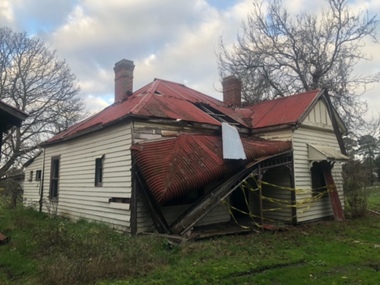
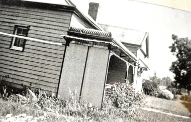
Photograph - Black and White, The Hedge (Tom Knee's House) 278 Yarra Road Wonga Park in 1949
The Hedge, aka Thomas Knee's house. Thomas Samuel Knee (born c. 1881in Lilydale) married Jane Maggs c. 1912, Thomas Samuel Knee's father Thomas Knee (married to Sarah Hardidge and who it appears was also an orchardist in Yarra Road) was rated for the land as vacant land at the turn of the century (c. 1900) Thomas Samuel Knee rated as owner of vacant land (CA14B of over 20 acres1911-12 and as a house 1912-13, next year CA 14C added making a total of 39 acres. It appears that Thomas Samuel Knee and his wife Jane lived at the property until 1949 when they moved to Montrose. In 1949 it was purchased by Hubert Victor (Vic) Eggleton after they migrated from Banstead in Surrey England. They had four boys Peter (who did a lot of the farming with Gladys), Brian, Michael and Roger. It was mixed farming: lemons, cherries, eggs, chickens and Gladys bred Spaniel dogs too. They had 2 dairy cows and a draft horse. The farm was larger then and was subdivided at a later date. The big dam was added too. the painting of the house was painted by a cousin of the Lusks. Ownership: Thomas Samuel Knee 1912-1949, Eggletons, 1949 - c.1953, then Timms, c. 1953 - early 1970s then Lusks early 1970s to c. 2012. The Lusks built a new house and after that the old house had various tenants. -
 Wonga Park Community Cottage History Group
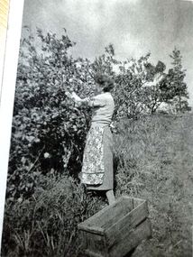
Photograph - Black and White, Wonga Park: Gladys Eggleton picking lemons between 1949 and 1953
The Hedge, aka Thomas Knee's house. Thomas Samuel Knee (born c. 1881in Lilydale) married Jane Maggs c. 1912, Thomas Samuel Knee's father Thomas Knee (married to Sarah Hardidge and who it appears was also an orchardist in Yarra Road) was rated for the land as vacant land at the turn of the century (c. 1900) Thomas Samuel Knee rated as owner of vacant land (CA14B of over 20 acres1911-12 and as a house 1912-13, next year CA 14C added making a total of 39 acres. It appears that Thomas Samuel Knee and his wife Jane lived at the property until 1949 when they moved to Montrose. In 1949 it was purchased by Hubert Victor (Vic) Eggleton after they migrated from Banstead in Surrey England. They had four boys Peter (who did a lot of the farming with Gladys), Brian, Michael and Roger. It was mixed farming: lemons, cherries, eggs, chickens and Gladys bred Spaniel dogs too. They had 2 dairy cows and a draft horse. The farm was larger then and was subdivided at a later date. The big dam was added too. the painting of the house was painted by a cousin of the Lusks. Ownership: Thomas Samuel Knee 1912-1949, Eggletons, 1949 - c.1953, then Timms, c. 1953 - early 1970s then Lusks early 1970s to c. 2012. The Lusks built a new house and after that the old house had various tenants. -
 Wonga Park Community Cottage History Group
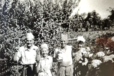
Photograph - Black and White, Wonga Park: Eggleton family's first Christmas in Australia 1949
The Hedge, aka Thomas Knee's house. Thomas Samuel Knee (born c. 1881in Lilydale) married Jane Maggs c. 1912, Thomas Samuel Knee's father Thomas Knee (married to Sarah Hardidge and who it appears was also an orchardist in Yarra Road) was rated for the land as vacant land at the turn of the century (c. 1900) Thomas Samuel Knee rated as owner of vacant land (CA14B of over 20 acres1911-12 and as a house 1912-13, next year CA 14C added making a total of 39 acres. It appears that Thomas Samuel Knee and his wife Jane lived at the property until 1949 when they moved to Montrose. In 1949 it was purchased by Hubert Victor (Vic) Eggleton after they migrated from Banstead in Surrey England. They had four boys Peter (who did a lot of the farming with Gladys), Brian, Michael and Roger. It was mixed farming: lemons, cherries, eggs, chickens and Gladys bred Spaniel dogs too. They had 2 dairy cows and a draft horse. The farm was larger then and was subdivided at a later date. The big dam was added too. the painting of the house was painted by a cousin of the Lusks. Ownership: Thomas Samuel Knee 1912-1949, Eggletons, 1949 - c.1953, then Timms, c. 1953 - early 1970s then Lusks early 1970s to c. 2012. The Lusks built a new house and after that the old house had various tenants. -
 Wonga Park Community Cottage History Group
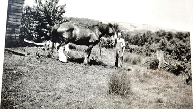
Photograph - Black and White, Wonga Park: Peter Eggleton with Captain, a draught horse between 1949 and 1953
The Hedge, aka Thomas Knee's house. Thomas Samuel Knee (born c. 1881in Lilydale) married Jane Maggs c. 1912, Thomas Samuel Knee's father Thomas Knee (married to Sarah Hardidge and who it appears was also an orchardist in Yarra Road) was rated for the land as vacant land at the turn of the century (c. 1900) Thomas Samuel Knee rated as owner of vacant land (CA14B of over 20 acres1911-12 and as a house 1912-13, next year CA 14C added making a total of 39 acres. It appears that Thomas Samuel Knee and his wife Jane lived at the property until 1949 when they moved to Montrose. In 1949 it was purchased by Hubert Victor (Vic) Eggleton after they migrated from Banstead in Surrey England. They had four boys Peter (who did a lot of the farming with Gladys), Brian, Michael and Roger. It was mixed farming: lemons, cherries, eggs, chickens and Gladys bred Spaniel dogs too. They had 2 dairy cows and a draft horse. The farm was larger then and was subdivided at a later date. The big dam was added too. the painting of the house was painted by a cousin of the Lusks. Ownership: Thomas Samuel Knee 1912-1949, Eggletons, 1949 - c.1953, then Timms, c. 1953 - early 1970s then Lusks early 1970s to c. 2012. The Lusks built a new house and after that the old house had various tenants. -
 Wonga Park Community Cottage History Group
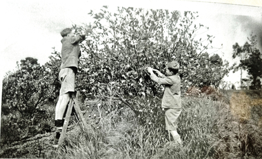
Photograph - Black and White, Wonga Park: Brian and Roger Eggleton picking lemons between 1949 and 1953
The Hedge, aka Thomas Knee's house. Thomas Samuel Knee (born c. 1881in Lilydale) married Jane Maggs c. 1912, Thomas Samuel Knee's father Thomas Knee (married to Sarah Hardidge and who it appears was also an orchardist in Yarra Road) was rated for the land as vacant land at the turn of the century (c. 1900) Thomas Samuel Knee rated as owner of vacant land (CA14B of over 20 acres1911-12 and as a house 1912-13, next year CA 14C added making a total of 39 acres. It appears that Thomas Samuel Knee and his wife Jane lived at the property until 1949 when they moved to Montrose. In 1949 it was purchased by Hubert Victor (Vic) Eggleton after they migrated from Banstead in Surrey England. They had four boys Peter (who did a lot of the farming with Gladys), Brian, Michael and Roger. It was mixed farming: lemons, cherries, eggs, chickens and Gladys bred Spaniel dogs too. They had 2 dairy cows and a draft horse. The farm was larger then and was subdivided at a later date. The big dam was added too. the painting of the house was painted by a cousin of the Lusks. Ownership: Thomas Samuel Knee 1912-1949, Eggletons, 1949 - c.1953, then Timms, c. 1953 - early 1970s then Lusks early 1970s to c. 2012. The Lusks built a new house and after that the old house had various tenants. -
 Melton City Libraries
Document, Darlingsford land title, 1863
Thomas Bell Darling purchased 176 acres from the Toolern Creek to Ferris Road. A house and bluestone barn/stables were built. The property was owned by Ralph Parkinson, followed by Richard Manning. SUMMARY – Darlingsford – Auction 1910 Darlingsford – Auction 1910 Melton Express October FRIDAY, October 28th At Three O’Clock At the RAGLAN HOTEL, MELTON SUBDIVISIONAL SALE of the DARLINGSFORD ESTATE, MELTON. Having a long frontage to the TOOLERN CREEK. In the Estate of the late RICHARD MANNING’ W. S. KEAST and L.A. FAIRBAIRN & CO., Auctioneers (in conjunction). Have received instructions from R.F. and J.L. Robertson, executors of Richard Manning deceased to offer by Public Auction, property almost adjoining Melton township, and having a frontage to the Toolern Creek, subdivided in to four lots as under:- Lot 1. – The homestead block containing 176 acres, being portion A, section 11, parish Kororoit together with the improvements, which consist of a 6-roomed stone house, milking shed, dairy, U.G. tank. Lot 2 – 177 acres 2 rood 23 perches, being Crown portion B of section 11 parish Kororoit. This block adjoins the homestead and is partly fenced. Lot 3 – 187 acres, Crown allotment C, section 11, parish Kororoit. adjoining the above lot. Lot 4 - 157 acres 1 rood 27 perches, being Crown allotment 9, section 12, parish of Kororoit. This block is only divided from the above lots by road, and adjoining Messrs. McVean and Gaitskill’s properties. This is one of the best known properties in the Melton district as a cultivation an grazing form, and its close proximity to the township makes it a very valuable, and portion of which could be cut into township blocks and should command a ready sale. For absolute sale. Terms- one fifth cash, one fifth in eight years, balance in 7 years with interest a the rate of 4 1/2 percent. Plan on application For further particulars apply W.S. KEAST, 610 Collins street, Melbourne; and L.A. FAIRBAIRN & Co., St James-buildings, Williams street, or at Bacchus Marsh; and as to the title, Dugdale and Creber, St. James-buildings, William Street Melbourne. Express November 5, 1910 On Friday last, Mr W.S. Keast and Messrs L.A. Fairbairn & Co., in conjunction, offered at the Raglan the Manning Estate known as Darlingsford, comprising of 700 acres, divided into four lots. Lot 4 was submitted first and passed in at L8 per acre. Lot 1 was then put up and went up to L13 per acre, at which it was also passed in. Lot 3 was next offered, and there being no bid was also passed in. Lot 2 was not offered. Express March 18, 1911 The Manning Estate of Darlingsford 600 acres was sold to Mr. Ernie for an undisclosed price. Note: Map KOROROIT COUNTY OF BOURKE Crown Grant Section 11 Portion A Thomas. B. Darling 176 . 0 . 0 acres on 29.3.1853 Lot 1 Portion B A. Russell 170 . 0 . 0 acres on 29.3.1853 Lot 2 Portion C Peter Inglis 176 . 0 . 0 acres on 29.3.1853 Lot 3 Section 12 Portion 3 P. Inglis 157 . 1 . 27 acres on 17.17.1863 Total 176 170 176 157. 1.27 679 . 1.27 acres November 5th 1910 On Friday night last Mr W S Keast and Messrs L A Fairbairn & Co, in conjunction offered at the Raglan Hotel the Manning Estate known as Darlingsford, comprising of 700 acres, divided into four Lots. Lot 4 was submitted first, and was passed in at L8.0.0. per acre. Lot 1 was then put up and went to L13.0.0. per acre at which it was passed in. Lot 3 was next offered, and then Lot 3 was next offered, and then being no bid was passed in. Lot 2 was not offered. October 22nd Notice of sale. 700 acres of splendid land close to the railway station. Divided onto 4 Lots 3 of which are maiden land and the whole of the acres is chocolate soil. No 1 Lot belonged to the late Mr Ralph Parkinson, and for years was liberally supplied with manure and crushed bones, and is capable of producing many crops.. The property being sold to wind up the Estate. Gisborne Gazette Friday December 17th 1911 Mr Sharp has sold his farm at the back of the township to Mr. E Barrie; price L15/10/ per acre. Agreement between Thomas Bell Darling and Ralph Parkinsonlocal identities -
 Port Melbourne Historical & Preservation Society
Book - Borough of Sandridge Valuation 1864-5, 1864
Valuation Book, 1864 Borough of Sandridge. Brown cover, red binding and label embossed in gold. 105 pages entered, listing name and occupation of tenant and owner of each property, description, number of rooms, size of property, rental etc. Blue paper insert at front, starting value of each block, and total. (also Rates; assessments)local government - borough of sandridge, built environment, william francis westall, john edward crockford, william may -
Port Melbourne Historical & Preservation Society
Book - Borough of Sandridge Valuation 1881, 1881
Valuation Book, Borough of Sandridge 1881. 119 spreads (+ summary on 134) listing name and occupation of tenant and owner of each property, description, number of rooms, size of property, rental etc. Dark French blue cloth cover, tan suede corners and spine with red, gold-stamped spine label (also Rates; assessments)Note in ink back of front endpaper 'No 1098 Omitted' Date inked lower left coverlocal government - borough of sandridge, built environment, william cruikshank, frederick peterson -
Port Melbourne Historical & Preservation Society
Book - Borough of Sandridge Valuation 1882, 1882
Valuation book, Borough of Sandridge 1882. Red (decorative) cover, red spine stamped in gold. 127 spreads (entire book used) listing name and occupation of tenant and owner of each property, description, number of rooms, size of property, annual rental etc. (also Rates; assessments)Notations inside back endpaper and last pagebuilt environment, william cruikshank, irwin walter brinton, local government - borough of sandridge -
Port Melbourne Historical & Preservation Society
Book - Borough of Port Melbourne Valuation 1881-82, 1881 - 1882
Valuation book, Borough of Port Melbourne 1881/82. 170 spreads completed listing name and occupation of tenant and owner of each property, description, number of rooms, size of property, rental etc. (Decorative) red cover, maroon spine with title gold-stamped. Spreads missing from the back include any signed and dated by valuer e.4e.119-129, 114-118 (also Rates; assessments)local government - borough of port melbourne, built environment, charles henry martin, joseph turner -
Port Melbourne Historical & Preservation Society
Book - Borough of Port Melbourne Valuation 1890, 1889 - 1890
Valuation book, Borough of Port Melbourne 1890. 170 spreads completed listing name and occupation of tenant and owner of each property, description, number of rooms, size of property, rental etc. (Decorative) red cover, maroon spine with title gold-stamped. (also Rates; assessments)local government - borough of port melbourne, built environment, charles henry martin, joseph turner -
Port Melbourne Historical & Preservation Society
Book - Town of Port Melbourne Valuation 1899, 1899
Valuation book, Town of Port Melbourne 1899. Dark grey with maroon spine and label gold-stamped. 71 spreads completed, listing name and occupation of tenant and owner of each property, description, number of rooms, size of property, rental etc. p72/3 removed, folded and placed in p73. (also Rates; assessments)"page 72-73 out for printers copy 29/9/00 ECC" on p73 Separate printers copy has order/instruction for next book in pencil, various markings on pages in pencil and in red ink (the latter indicating cross streets) Signed by Mayor, Town Clerk and an unidentifiable Councillorlocal government, built environment, joseph turner, edward c crockford, town clerks, henry norval edwards -
Port Melbourne Historical & Preservation Society
Book - Town of Port Melbourne Valuation 1900-01, 1900
Valuation book, Town of Port Melbourne 1900-01. Dark green cloth cover with maroon spine and label gold-stamped. 70 spreads completed, listing name and occupation of tenant and owner of each property, description, number of rooms, size of property, rental etc. Letter from valuer detailing demolition etc pasted p 70. Pages 73-77 removed but 72/74 and 76/77 placed in book. (also Rates; assessments)Markings in pencil. Cross streets added in red pen. Notes on lined paper pasted front end paper.local government, built environment, joseph turner -
Port Melbourne Historical & Preservation Society
Book - Town of Port Melbourne Valuation 1898-99, 1898
Valuation book, Town of Port Melbourne 1898-99. Dark green cloth cover, maroon spine and label gold-stamped. 70 spreads completed, listing name and occupation of tenant and owner of each property, description, number of rooms, size of property, rental etc. Two pp letter detailing demolitions etc pasted to p. 70 (also Rates; assessments)Cross streets added in red ink. Signed by Town Clerk. Pencil markings in marginlocal government, built environment, joseph turner, edward c crockford, town clerks -
Port Melbourne Historical & Preservation Society
Book - Town of Port Melbourne Valuation 1901-02, 1901
Valuation book, Town of Port Melbourne 1901-02 Purple-black cloth cover, maroon binding and cover gold-stamped. 69 spreads completed, listing name and occupation of tenant and owner of each property, description, number of rooms, size of property, rental etc. Letter from valuer detailing demolition etc pasted p 69; 2 pieces correspondence to Council pasted p. 68 (also Rates; assessments)Figures in ink, back end paper.local government, built environment, joseph turner -
Port Melbourne Historical & Preservation Society
Book - Borough of Sandridge Valuation 1877, 1876
Valuation Book, Borough of Sandridge 1877. Reddish marbled cover with tan leather spine and corner bindings, red leather, goldstamped, red label on spine. 127 spreads listing name and occupation of tenant and owner of each property, description, number of rooms, size of property, rental etc., plus p128 (also Rates; assessments)Signed by Town Clerk and Mayor as well as valuers; '1877-78' in ink lower left of cover (90 degrees)local government - borough of sandridge, built environment, frederick peterson, william cruikshank, edward clark, town clerks, john turnbull -
Port Melbourne Historical & Preservation Society
Book - Borough of Sandridge Valuation 1873, 1872
Valuation Book, Borough of Sandridge 1873. 111 spreads listing name and occupation of tenant and owner of each property, description, number of rooms, size of property, rental etc. (additional info on 113-114. Worn, mouldy, marbled cover, red spine with gold stamping (also Rates; assessments)local government - borough of sandridge, built environment, william cruikshank -
Port Melbourne Historical & Preservation Society
Book - Borough of Port Melbourne Valuation 1895, 1895
Valuation book, Borough of Port Melbourne 1895. Bluegreen marbled cover, maroon spine gold-stamped front label. 74 of 89 spreads completed listing name and occupation of tenant and owner of each property, description, number of rooms, size of property, rental etc. Two page insert stitched into 74, being letter from valuer handwritten on lined paper, detailing new development as well as houses demolished. (also Rates; assessments)local government, built environment, joseph turner -
Bendigo Historical Society Inc.
Document - Samson's Cottage Significance Assessment, 1967
The first, two-roomed, stage of the present cottage appears to have been commenced before 1866, when the first rate notice appeared (Shire of Marong) and possibly as early as the mid-1850s, when the first owner, Thomas Samson, a shoemaker turned joiner, came to the Bendigo goldfields. Samson took up a miner's right in Spec(k) Gully in the mid-1850s. The Samson family had ten children and as the family grew they extended the cottage in stages. Samson worked as a miner until about 1871, then returned to boot making from a weatherboard shed on the property. He opened a shop on the corner of Booth and McKenzie Streets in partnership with John Shocker in 1889. He died in 1893. His wife Sarah remained in the cottage until 1906. Albert and Florence Doye purchased the site in 1908 and the family lived there until 1966. The property has remained in the hands of the family, mostly unoccupied. It was renovated by a tenant in the 1970s and passed from miner's right to freehold in 1974. It is currently owned by Arthur Doye, who lives nearby, and is unoccupied. During its early life it, probably during the Samson occupation, it was altered and extended many times into a complex arrangement of structures and outbuildings. Stone remained the dominant building material throughout, even for the poultry shedsThree page report on the significance of Sansom's Cottage, 21 Doye Street, Golden Square, Bendigo. Topics include what is significant; why is it significant; permit exemptions; assessment against criteria; extent of registration and contextual history. Final page on 'history of place' is missing from document.sansom cottage, golden square, heritage register, sandstone, miner, shoemaker, thomas sansom -
 St Kilda Historical Society
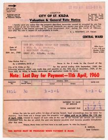
Administrative record - Notice, Valuation and General Rate Notice, 1960
A valuation and general rate notice that was issued in 1960 by the City of St Kilda for property held by the 2nd St Kilda Boy Scouts Troop.Pink coloured paper printed in black on both sides and inscribed with handwritten details in blueHandwritten details of assessment: no. 8826; nett annual value £30; rates due £2-2-6. Stamped cash register receipt for payment made on 1 July 1960.boy scouts, city of st kilda, st kilda rates -
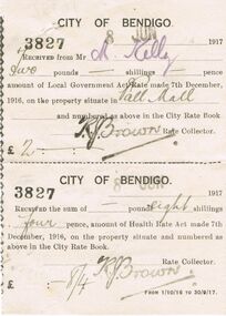 Bendigo Historical Society Inc.
Document - CITY OF BENDIGO RATE RECEIPT, 08/06/1917
BHS CollectionCity of Bendigo Rate Receipt: Receipt no 3827 dated 8th June 1917. White paper with black print. Received from Mr M. Kelly, two pounds. Amount of Local government Act Rate made 7th December, 1916, on the property situate in Pall Mall and numbered as above in the City Rate book. K.J. Brown Rate Collector. £2:. City of Bendigo receipt no. 3827 dated 8th June 1917. Received the sum of eight shillings four pence, amount of Health Rate Act made 7th December, 1916, on the property situate and numbered as above in the City Rate Book. K.J. Brown. £ :8:4 pence. From 01/10/16 to 30/09/17. Box 625bendigo, council, city of bendigo. k. j. brown. m kelly