Showing 302 items matching " swamp"
-
 Eltham District Historical Society Inc
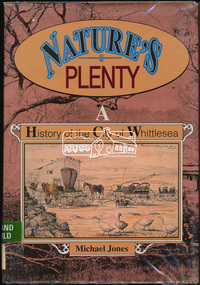
Book, Michael Jones, Nature's plenty : a history of the City of Whittlesea, 1992
... Possible use of a 'swamp management system' now buried under Yan Yean reservoir. ...Possible use of a 'swamp management system' now buried under Yan Yean reservoir. ...This book explores Whittlesea's history from early 1830's to 1991. Environment of the Aboriginal people about the the time of European settlement. Possible use of a 'swamp management system' now buried under Yan Yean reservoir. Smallpox epidemics among Aboriginal people prior to settlement - probably from the activity of nearby European sealers. Estimations of Aboriginal populations. Scattered references throughout. Subjects Health - Infectious diseases - Smallpox. Settlement and contacts - Colonisation - 1788-1850. Settlement and contacts - Colonisation - 1851- Environment - Land management. Demography. Woiwurrung / Wurundjeri / Woiwurung people (S36) (Vic SJ55-05) Yan Yean (Vic SJ55-05) Eden Park (Vic SJ55-05) Whittlesea (Vic SJ55-05) Diamond Creek (Vic SJ55-05) Kingslake (Vic SJ55-05) Whittlesea (Vic.) -- History.xvi, 319 p., [16] p. of plates : ill. (some col.), maps (some col.), ports. ; 28 cm. the plenty, farming, settlement, gold rush, plenty river, donnybrook, germantown, separation, thomastown, whittlesea, epping, woodstock, city of whittlesea, railway, yan yean, roll of honour -
 Mortlake and District Historical Society
Photograph - Montgomery Pavillion, Montgomery Pagoda or Pavillion, 1924
... Cr Montgomery, a local businessman and a councillor, had loved the gardens and had assisted to transform the area from a swamp into a thing of beauty. The design was chosed by his widow who had seen a smilar design in King's Park whilst in Perth so the plans were obtained from that City. ...Cr Montgomery, a local businessman and a councillor, had loved the gardens and had assisted to transform the area from a swamp into a thing of beauty. The design was chosed by his widow who had seen a smilar design in King's Park whilst in Perth so the plans were obtained from that City. ...In July 1922 Rev. W. McBride of the St Andrews Presbyterian Church, Mortlake had a meeting with the Garden sub-committee to discuss how the 500 pounds sterling bequest from the Late Thomas Montgomery could best be spent. His suggestion was that the money should be spent on either a kiosk, pavillion or recreation hall and pavillion combines with kitchen and fireplace was agreed to with exact site to decided at a public meeting. Cr Montgomery, a local businessman and a councillor, had loved the gardens and had assisted to transform the area from a swamp into a thing of beauty. The design was chosed by his widow who had seen a smilar design in King's Park whilst in Perth so the plans were obtained from that City. The work was carried out by Archibald Cluny McDonald and completed in September 1924. In December 1924 the Montgomery Pagado was unveiled to the public by Cr Wells Brumley after which the Red Cross ladies served tea.THIS TABLET IS DESIGNED TO COMMEMORATE THE GENEROSITY OF THE LATE COUNCILLOR THOMAS MONTGOMERY BY WHOM THIS PAVILLION WAS GRACIOUSLY BEQUEATHED TO THE TOWN OF MORTLAKE AND TO PERPETUATE THE MEMORY OF HIS NOBILITY OF CHARACTER AND EXTREME WORTH AS A CITIZENpagoda -
 City of Kingston
Photograph - Colour, Paul Tresize, 1998
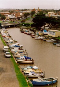
... The reserved land included part of the Carrum Carrum Swamp which was abundant with wild life and natural resources. ...The reserved land included part of the Carrum Carrum Swamp which was abundant with wild life and natural resources. ...The name Mordialloc was derived from the name Moody Yallock, which comes from the Bunurong language. The Bunurong Peoples are the Traditional Owners of this area. The name means “high water” or “high creek”. In 1839, colonial authorities declared the mouth of the creek, and an additional 830 odd acres as an Aboriginal Reserve, although this proclamation was never gazetted. The reserved land included part of the Carrum Carrum Swamp which was abundant with wild life and natural resources. Regular encroachments, including land sales which began in 1863, were made on the land until 1878 when the Reserve was declared closed, and the land was opened up to land sales. Market gardening and suburban house lots quickly began to develop, and Mordialloc became a renowned picnic and holiday site. Mordialloc Creek is a popular bay side destination for local and visitors, and is a site for boating, kayaking, fishing and swimming, along with many other activities.Colour photograph of Mordialloc Creek, looking out to the bay. Many small fishing and leisure craft are moored on either side of the banks of the creek. To the right hand side can be seen parklands, while the left hand side has a small inlet in which more small crafts are moored.mordialloc, bunurong, traditional owners, suburbs, boats, fishing, waterways -
 City of Kingston
Photograph - Colour, 1998
... The reserved land included part of the Carrum Carrum Swamp which was abundant with wild life and natural resources. ...The reserved land included part of the Carrum Carrum Swamp which was abundant with wild life and natural resources. ...The name Mordialloc was derived from the name Moody Yallock, which comes from the Bunurong language. The Bunurong Peoples are the Traditional Owners of this area. The name means “high water” or “high creek”. In 1839, colonial authorities declared the mouth of the creek, and an additional 830 odd acres as an Aboriginal Reserve, although this proclamation was never gazetted. The reserved land included part of the Carrum Carrum Swamp which was abundant with wild life and natural resources. Regular encroachments, including land sales which began in 1863, were made on the land until 1878 when the Reserve was declared closed, and the land was opened up to land sales. Market gardening and suburban house lots quickly began to develop, and Mordialloc became a renowned picnic and holiday site. Mordialloc Creek is a popular bay side destination for local and visitors, and is a site for boating, kayaking, fishing and swimming, along with many other activities.Colour photograph of Mordialloc Creek, looking inland.Small fishing and leisure boats are moored on either side of creek, with a view of the Mordialloc Bridge Hotel in the background.mordialloc, bunurong, traditional owners, suburbs, boats, fishing, waterways, hotel -
 City of Kingston
Photograph - Colour, Paul Tresize, 1998
... The reserved land included part of the Carrum Carrum Swamp which was abundant with wild life and natural resources. ...The reserved land included part of the Carrum Carrum Swamp which was abundant with wild life and natural resources. ...The name Mordialloc was derived from the name Moody Yallock, which comes from the Bunurong language. The Bunurong Peoples are the Traditional Owners of this area. The name means “high water” or “high creek”. In 1839, colonial authorities declared the mouth of the creek, and an additional 830 odd acres as an Aboriginal Reserve, although this proclamation was never gazetted. The reserved land included part of the Carrum Carrum Swamp which was abundant with wild life and natural resources. Regular encroachments, including land sales which began in 1863, were made on the land until 1878 when the Reserve was declared closed, and the land was opened up to land sales. Market gardening and suburban house lots quickly began to develop, and Mordialloc became a renowned picnic and holiday site. Mordialloc Creek is a popular bay side destination for local and visitors, and is a site for boating, kayaking, fishing and swimming, along with many other activities.Colour photograph of Mordialloc Creek, looking inland. Boats are moored on either side of the creek and the Bridge Hotel is visible in the background.mordialloc, bunurong, traditional owners, suburbs, boats, fishing, waterways, hotel -
 City of Kingston
Photograph - Colour, Paul Tresize, 1998
... The reserved land included part of the Carrum Carrum Swamp which was abundant with wild life and natural resources. ...The reserved land included part of the Carrum Carrum Swamp which was abundant with wild life and natural resources. ...The name Mordialloc was derived from the name Moody Yallock, which comes from the Bunurong language. The Bunurong Peoples are the Traditional Owners of this area. The name means “high water” or “high creek”. In 1839, colonial authorities declared the mouth of the creek, and an additional 830 odd acres as an Aboriginal Reserve, although this proclamation was never gazetted. The reserved land included part of the Carrum Carrum Swamp which was abundant with wild life and natural resources. Regular encroachments, including land sales which began in 1863, were made on the land until 1878 when the Reserve was declared closed, and the land was opened up to land sales. Market gardening and suburban house lots quickly began to develop, and Mordialloc became a renowned picnic and holiday site. Mordialloc Creek is a popular bay side destination for local and visitors, and is a site for boating, kayaking, fishing and swimming, along with many other activities.Colour photograph of Mordialloc Creek with boats moored on both sides of the street and Pompei's boat yard visible on the right hand side of the creek., Main Street and St Brigid's Catholic Church are visible in backgroundmordialloc, bunurong, traditional owners, suburbs, boats, fishing, waterways, hotel, church -
City of Kingston
Photograph - Colour, Paul Tresize, 1998
... The reserved land included part of the Carrum Carrum Swamp which was abundant with wild life and natural resources. ...The reserved land included part of the Carrum Carrum Swamp which was abundant with wild life and natural resources. ...The name Mordialloc was derived from the name Moody Yallock, which comes from the Bunurong language. The Bunurong Peoples are the Traditional Owners of this area. The name means “high water” or “high creek”. In 1839, colonial authorities declared the mouth of the creek, and an additional 830 odd acres as an Aboriginal Reserve, although this proclamation was never gazetted. The reserved land included part of the Carrum Carrum Swamp which was abundant with wild life and natural resources. Regular encroachments, including land sales which began in 1863, were made on the land until 1878 when the Reserve was declared closed, and the land was opened up to land sales. Market gardening and suburban house lots quickly began to develop, and Mordialloc became a renowned picnic and holiday site. Mordialloc Creek is a popular bay side destination for local and visitors, and is a site for boating, kayaking, fishing and swimming, along with many other activities.Colour photograph of Mordialloc Creek with boats moored on both sides of the street and Pompei's boat yard visible on the right hand side of the creek., Main Street and St Brigid's Catholic Church are visible in background.mordialloc, bunurong, traditional owners, boats, fishing -
Queenscliffe Maritime Museum
Functional object - Bottle
... Attempts were made to launch the boats but they were swamped and dashed to pieces. Delays in getting the lifeboat and rocket apparatus to the scene resulted in 12 of the 25 crew drowning after 10 hours trapped on board. ...Attempts were made to launch the boats but they were swamped and dashed to pieces. Delays in getting the lifeboat and rocket apparatus to the scene resulted in 12 of the 25 crew drowning after 10 hours trapped on board. ...Recovered from the wreck site of the Fiji. The barque Fiji left Hamburg on 22nd of May 1891. The vessel went ashore at 3 am on the morning of the 6th of September 1891in squally and boisterous weather soon after sighting Cape Otway. The wind had suddenly veered, and the vessel missed stays after attempting to wear ship and was driven onto the rocks. Attempts were made to launch the boats but they were swamped and dashed to pieces. Delays in getting the lifeboat and rocket apparatus to the scene resulted in 12 of the 25 crew drowning after 10 hours trapped on board. A local resident, Arthur Wilkinson, lost his life trying to save one of the crew who was struggling in the surf. Coffins were made out of the wreck timbers and the men buried on the cliff top above the wreck. The deaths precipitated critical comment in the press over the lack of prompt action. Other news items appeared claiming drunk and disorderly behaviour by plunderers amongst the corpses and wreckage on the beach. The controversy reached parliament.Brown bottleWarner's, Safe, Cure, Melbourne Aust, London Eng, Toronto Can, Rochester NY USAwrecks, salvage, bottle, barque fiji -
 Bendigo Historical Society Inc.
Document - Heritage Assessment, December 2020
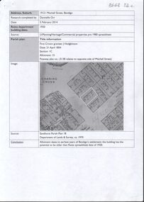
... At this time, the section of Mitchell Street and Pall Mall, which later came to be known as 'Pikes Corner' was considered a 'semi-swamp, for the ground had all been turned up by the diggers, being the foot of Pennyweight Gully, just where it joined the Bendigo Creek and there was more water than land to be seen of it.....I think the three allotments cost him less than 100 pounds each' (Bendigo Advertiser, 9th November, 1889, page 6, letter 'Pikes Corner'). ...At this time, the section of Mitchell Street and Pall Mall, which later came to be known as 'Pikes Corner' was considered a 'semi-swamp, for the ground had all been turned up by the diggers, being the foot of Pennyweight Gully, just where it joined the Bendigo Creek and there was more water than land to be seen of it.....I think the three allotments cost him less than 100 pounds each' (Bendigo Advertiser, 9th November, 1889, page 6, letter 'Pikes Corner'). ...The four allotments along the eastern side of Mitchell Street from Pall Mall to Hargreaves Street, were all first transferred from the Crown on the 21st and 22nd. of April 1854 ( Parish Plan, Section 1C, allotment 15 - now known as 19 - 21 Mitchell Street, Bendigo. The surrounding properties along Mitchell Street were transferred from the Crown to J. Pike (to corner with Pall Mall) and Henry Backhaus ( corner of Mitchell Street and Hargreaves Street, also on the 21st and 22nd. April 1854). At this time, the section of Mitchell Street and Pall Mall, which later came to be known as 'Pikes Corner' was considered a 'semi-swamp, for the ground had all been turned up by the diggers, being the foot of Pennyweight Gully, just where it joined the Bendigo Creek and there was more water than land to be seen of it.....I think the three allotments cost him less than 100 pounds each' (Bendigo Advertiser, 9th November, 1889, page 6, letter 'Pikes Corner'). Nine page photocopy of typed document prepared by the City of Greater Bendigo on the history of the allotments 19 - 21 Mitchell Street, Bendigo. Report contains information on the early history of that section of Mitchell Street, dating from 1854 to 1902; photocopied images of Bendigo Wire Works; Webster Brothers and John Pykes (Pikes) allotments. A comprehensive rate book search, conducted by BRAC and PROV is included in the report, information includes year of rate notice, number of assessment, ratepayers name and occupation, owner's name and occupation, property description, address and net annual value. sandhurst, mitchell street, pall mall, pike's corner, henry backhaus, 19 - 21 mitchell street, charing cross, bendigo wire works, webster bros -
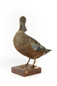 The Beechworth Burke Museum
Animal specimen - Australiasian Shovelor, Trustees of the Australian Museum, 1860-1880
... The Australasian Shoveler is a species of duck that can be commonly found in heavily vegetated swamps in southwestern and southeastern Australia, Tasmania and New Zealand. ...The Beechworth Burke Museum Loch Street Beechworth high-country The Australasian Shoveler is a species of duck that can be commonly found in heavily vegetated swamps in southwestern and southeastern Australia, Tasmania and New Zealand. ...The Australasian Shoveler is a species of duck that can be commonly found in heavily vegetated swamps in southwestern and southeastern Australia, Tasmania and New Zealand. The species, Australasian Shoveler, is aptly named after their large shovel-shaped bill. These birds use these large bills which are equipped with fine hair-like components which strain the water and mud for food including tiny creatures including insects, crustaceans and seeds while it swims. This specimen is part of a collection of almost 200 animal specimens that were originally acquired as skins from various institutions across Australia, including the Australian Museum in Sydney and the National Museum of Victoria (known as Museums Victoria since 1983), as well as individuals such as amateur anthropologist Reynell Eveleigh Johns between 1860-1880. These skins were then mounted by members of the Burke Museum Committee and put-on display in the formal space of the Museum’s original exhibition hall where they continue to be on display. This display of taxidermy mounts initially served to instruct visitors to the Burke Museum of the natural world around them, today it serves as an insight into the collecting habits of the 19th century.This specimen is part of a significant and rare taxidermy mount collection in the Burke Museum. This collection is scientifically and culturally important for reminding us of how science continues to shape our understanding of the modern world. They demonstrate a capacity to hold evidence of how Australia’s fauna history existed in the past and are potentially important for future environmental research. This collection continues to be on display in the Museum and has become a key part to interpreting the collecting habits of the 19th century.This Australasian Shoveler is a species of low-floating duck with a dark head and brown plumage. The rear of this specimen is a dark brown, with mixed white and brown colouring on the upper torso. The underparts of this bird are brown and orange. The specimen has glass eyes made in an amber colour. The Shoveler is standing on a wooden platform which is labelled number 136. Amongst the feathers on the wings, this bird has a green coloured feather. The legs of the Shoveler would have once been a bright orange; however, the legs of this specimen have darkened in colour throughout the taxidermy process. This bird has a large bill shaped like a shovel from which the name "Shoveler" has been derived.5a. / Australian Shoveller / See Catalogue, page 38. /taxidermy mount, taxidermy, animalia, burke museum, beechworth, australian museum, skin, reynell eveleigh johns, bird, australian birds, heron, duck, australaisian shovelor, shovelor -
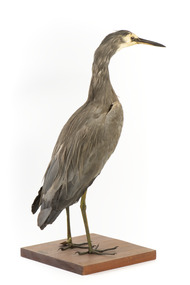 The Beechworth Burke Museum
Animal specimen - White Faced Heron, Trustees of the Australian Museum, 1860-1880
... The White-faced heron typically resides in wetland habitats including reefs, rock pools, swamps and rivers. They feed on small aquatic animals. ...The White-faced heron typically resides in wetland habitats including reefs, rock pools, swamps and rivers. They feed on small aquatic animals. ...The White-faced Heron is a common bird located throughout Australasia, including New Guinea, Torres Strait, Indonesia and New Zealand. It can be found in all parts of Australia with the exception of areas which are too dry. The White-faced heron typically resides in wetland habitats including reefs, rock pools, swamps and rivers. They feed on small aquatic animals. These birds get their name from their characteristic white face which contrasts to the ashen grey plumage of their bodies. This specimen is part of a collection of almost 200 animal specimens that were originally acquired as skins from various institutions across Australia, including the Australian Museum in Sydney and the National Museum of Victoria (known as Museums Victoria since 1983), as well as individuals such as amateur anthropologist Reynell Eveleigh Johns between 1860-1880. These skins were then mounted by members of the Burke Museum Committee and put-on display in the formal space of the Museum’s original exhibition hall where they continue to be on display. This display of taxidermy mounts initially served to instruct visitors to the Burke Museum of the natural world around them, today it serves as an insight into the collecting habits of the 19th century.This specimen is part of a significant and rare taxidermy mount collection in the Burke Museum. This collection is scientifically and culturally important for reminding us of how science continues to shape our understanding of the modern world. They demonstrate a capacity to hold evidence of how Australia’s fauna history existed in the past and are potentially important for future environmental research. This collection continues to be on display in the Museum and has become a key part to interpreting the collecting habits of the 19th century.The White Faced Heron is stylised in a standing position on a wooden platform, looking forward. The bird has small brown glass eyes in place of the original. The Heron has long dark legs and is mostly covered in grey-brown plumage. Around the face, the plumage is a cream colour. The bill is black. This particular specimen has a paper identification tag tied around its left leg.....[missing] Heron / ....[missing] page 34. /taxidermy mount, taxidermy, animalia, burke museum, beechworth, australian museum, skin, reynell eveleigh johns, bird, australian birds, heron, white faced heron -
 Bayside Gallery - Bayside City Council Art & Heritage Collection
Painting - oil and acrylic on canvas, Robert Kelly, Chinaman's Creek, 2016
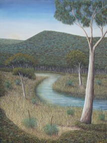
... Chinaman’s Creek in Capel Sound (Rosebud West) was an important watercourse that originally ran from Wonga (Arthur’s Seat) down through Tootgarook Swamp into Port Phillip Bay. It was a great fresh water and food source and home for many Boonwurrung people. ...Chinaman’s Creek in Capel Sound (Rosebud West) was an important watercourse that originally ran from Wonga (Arthur’s Seat) down through Tootgarook Swamp into Port Phillip Bay. It was a great fresh water and food source and home for many Boonwurrung people. ...Bob Kelly paints landscapes of culturally significant sites along the Mornington Peninsula and depicts these locations as he imagines they originally were before colonisation. Using traditional Western painting techniques, Kelly records the underlying spirit of the Peninsula from a Wathaurong perspective. Chinaman’s Creek in Capel Sound (Rosebud West) was an important watercourse that originally ran from Wonga (Arthur’s Seat) down through Tootgarook Swamp into Port Phillip Bay. It was a great fresh water and food source and home for many Boonwurrung people. Since settlement over 170 years ago, the creek has been drained, blocked, reconstructed and damaged. Kelly depicts a lush green landscape in which the clean creek water winds through the surrounding vegetation of spinifex grasses and gum trees, the background hills are abundant with trees, untouched from man's intervention. Using painstaking detail, Kelly records each blade of grass and ripple on the surface of Chinaman’s Creek. His attention to detail serves to powerfully reimagine this important cultural site, returning it to its former pristine state, and reinvigorating its role as a key place of sustenance for the Indigenous populations of the Peninsula. Chinaman's Creek was a finalist in the 2017 Bayside Acquisitive Art Prize.oil and acrylic on canvaslandscape, creek, trees, chinaman's creek, painting, indigenous, robert kelly, bayside acquisitive art prize, bob kelly, wathaurong, rosebud, arthur's seat, tootgarook swamp, port phillip bay, boonwurrung -
![Scene near Corranderrk Station / [by] Nicholas Caire, circa 1876](/media/collectors/550653872162f11fb04854aa/items/57774ae0d0cdd10a5c12f2d7/item-media/57774b61d0cdd10a5c132dac/item-fit-380x285.jpg?cb=6) Kew Historical Society Inc
Kew Historical Society IncPhotograph, Anglo-Australasian Photographic Company, Scene near Corranderrk Station, c. 1876
... The roadway which is seen in the mid-distance has lately been constructed by the Government, / as the old tracks which formerly existed, were liable to be swamped by the periodical overflowing of the River. ...The roadway which is seen in the mid-distance has lately been constructed by the Government, / as the old tracks which formerly existed, were liable to be swamped by the periodical overflowing of the River. ...Nicholas Caire was born on Guernsey in the Channel Islands in 1837. He arrived in Adelaide with his parents in about 1860. In 1867, following photographic journeys in Gippsland, he opened a studio in Adelaide. From 1870 to 1876 he lived and worked in Talbot in Central Victoria. In 1876 he purchased T. F. Chuck's studios in the Royal Arcade Melbourne. In 1885, following the introduction of dry plate photography, he began a series of landscape series, which were commercially successful. As a photographer, he travelled extensively through Victoria, photographing places few of his contemporaries had previously seen. He died in 1918. Reference: Jack Cato, 'Caire, Nicholas John (1837–1918)', Australian Dictionary of Biography. The 1860s marked the beginning of the era of reserves and missions. Six Aboriginal reserves were established during the 1860s. These were under the control of the Board for the Protection of Aborigines. Four were Christian missions receiving government aid. These were Lake Tyers (Anglican) and Ramahyuck (Presbyterian/Moravian) in eastern Victoria for the Gunai/Kurnai clans; Ebenezer (Moravian) in north-west Victoria for the clans of the Wimmera and Lower Murray; and Lake Condah (Anglican) in south-west Victoria. The other two were secular government controlled reserves: Framlingham which, like Lake Condah, was established for the Mara-speaking Gunditjmara and Kirrae-wurrung people of south-west Victoria; and Coranderrk, located about 60 kilometres north-east of Melbourne, for the Kulin clans of central Victoria. In 1863, after a period of devastation to the Kulin people, Coranderrk was established at the junction of the Yarra River and Badger Creek. Reference: http://coranderrk.com/, accessed 24 December 2016An original, rare photograph from the series 'Views of Victoria: General Series' by the photographer, Nicholas Caire (1837-1918). The series of 60 photographs that comprise the series was issued c. 1876 and reinforced a neo-Romantic view of the Australian landscape to which a growing nationalist movement would respond. Nicholas Caire was active as a photographer in Australia from 1858 until his death in 1918. His vision of the Australian bush and pioneer life had a counterpart in the works of Henry Lawson and other nationalist poets, authors and painters.Albumen silver photograph mounted on boardprinted in ink on support l.c.: SCENE NEAR "CORRANDERRK" STATION. / COPYRIGHT REGISTERED. printed in ink on support reverse c.: VIEWS OF VICTORIA. / (GENERAL SERIES.) / No. 9. / SCENE NEAR "CORRANDERRK" STATION. / This scene was taken from the hill near Rourke's Bridge, on the Healesville Road, and displays in the foreground / the River Yarra. The roadway which is seen in the mid-distance has lately been constructed by the Government, / as the old tracks which formerly existed, were liable to be swamped by the periodical overflowing of the River. Mount / Ridell can be seen in the extreme distance immediately behind the roadway. / Corranderrk is the local habitation / for the natives of this district, and is situated on the right hand side of the picture, about a mile and a half / from the roadway. printed in ink on support reverse l.c.l.: J.W. FORBES, Agent, printed in ink on support reverse l.c.: ANGLO-AUSTRALASIAN PHOTOGRAPHIC COMPANY, MELBOURNE. printed in ink on support reverse l.c.r.: 10 Temple Court, Collins Street West.nicholas caire (1837-1918), coranderrk aboriginal station, aborigine, yarra river, badger creek, first peoples, aboriginal and torres straight islander -
Glen Eira Historical Society
Article - Vegetation
... Contains three black-and-white photographs of portraying three species of said vegetation – the swamp gum, the Kangaroo Apple and Poa grass. 3/An article from the Southern Cross, dated 13/05/1992, pertaining to Caulfield’s indigenous vegetation, and the efforts of groups and individuals such as the Caulfield Environment Group (CEG) to preserve it. ...Contains three black-and-white photographs of portraying three species of said vegetation – the swamp gum, the Kangaroo Apple and Poa grass. 3/An article from the Southern Cross, dated 13/05/1992, pertaining to Caulfield’s indigenous vegetation, and the efforts of groups and individuals such as the Caulfield Environment Group (CEG) to preserve it. ...Four items pertaining to vegetation within Caulfield: 1/2 copies of a booklet produced by the Caulfield City Council (undated) offering residents advice on the planting and care of trees within the district. Contains seven black-and-white photographs portraying various spots of vegetation within the district, plus nine black-and-white cartoons portraying the steps involved in correctly planting a tree. 2/An article from the Caulfield Contact, dated 04/1992, pertaining to Caulfield’s indigenous vegetation. Contains three black-and-white photographs of portraying three species of said vegetation – the swamp gum, the Kangaroo Apple and Poa grass. 3/An article from the Southern Cross, dated 13/05/1992, pertaining to Caulfield’s indigenous vegetation, and the efforts of groups and individuals such as the Caulfield Environment Group (CEG) to preserve it. Contains a black-and-white photograph of CEG member Paul Cain with a Red River Gum and large tussock grass, part of a re-vegetation program in a Murrumbeena linear park. 4/ A clipping from the Southern Cross, dated 20/05/1992, pertaining to the presence of Murray River red gum at Elsternwick primary school. Contains a black-and-white photograph of two pupils of the school, Craig and Emelia (surnames unmentioned), planting saplings.caulfield, plants, trees, caulfield city council, gardening, horticulture, landscape planning, caulfield contact, outer circle parklands, caulfield environment group, cain paul, smith colin, joint effort community house, outer circle railway, conservation of natural resources, murrumbeena, parks, minister for conservation, pullen barry, glenhuntly neighbourhood house, primary schools, elsternwick primary school, murphy street, mcinerney peter, elster canal -
 The Beechworth Burke Museum
Animal specimen - Yellow Billed spoonbill, Trustees of the Australian Museum, 1860-1880
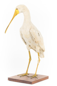
... It resides in freshwater wetlands, dams, lagoons and swamps. The species feeds on mainly aquatic insects and larvae. ...It resides in freshwater wetlands, dams, lagoons and swamps. The species feeds on mainly aquatic insects and larvae. ...The Yellow-billed spoonbill is a waterbird which can be commonly seen wading through shallow waters. This particular variety of Spoonbill is found across Australia, mostly in the northern and well-watered inland areas. It resides in freshwater wetlands, dams, lagoons and swamps. The species feeds on mainly aquatic insects and larvae. The bill has vibration detectors called papillae inside the spoon which enables the bird to feel the vibrations of its prey in murky water. These birds nest in the colonies of other birds like the Ibises and Royal Spoonbills. They live in high forks of trees over water or in reed beds. This specimen is part of a collection of almost 200 animal specimens that were originally acquired as skins from various institutions across Australia, including the Australian Museum in Sydney and the National Museum of Victoria (known as Museums Victoria since 1983), as well as individuals such as amateur anthropologist Reynell Eveleigh Johns between 1860-1880. These skins were then mounted by members of the Burke Museum Committee and put-on display in the formal space of the Museum’s original exhibition hall where they continue to be on display. This display of taxidermy mounts initially served to instruct visitors to the Burke Museum of the natural world around them, today it serves as an insight into the collecting habits of the 19th century.This specimen is part of a significant and rare taxidermy mount collection in the Burke Museum. This collection is scientifically and culturally important for reminding us of how science continues to shape our understanding of the modern world. They demonstrate a capacity to hold evidence of how Australia’s fauna history existed in the past and are potentially important for future environmental research. This collection continues to be on display in the Museum and has become a key part to interpreting the collecting habits of the 19th century.The Yellow-billed spoonbill specimen is a large taxidermy of mainly white colouring. The bill is a large and unique spoon shape and is yellow. The long gangly legs and the skin on the face are also yellow. The eyes are made from a black and yellow glass and the bird is stylized standing on a square wooden platform. A paper identification tag is tied to the bird's upper left leg.6c. / [illegible] / Spoonbill / taxidermy mount, taxidermy, animalia, burke museum, beechworth, australian museum, skin, reynell eveleigh johns, bird, australian birds, spoonbill, yellow-billed spoonbill, yellow billed spoonbill, waterbird -
 Ballarat Tramway Museum
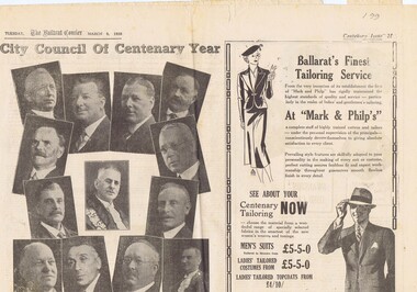
Newspaper, The Courier Ballarat, Courier, 8/3/1938 p21, 22, 29 & 30 - photo of Sturt St, Mar. 1938
... Page 30 - articles - Ballarat's sporting origins and swamp to reservoir (water supply). Photos of First England Cricket team to visit Ballarat and aqueduct at Kirks storage basin. ...Page 30 - articles - Ballarat's sporting origins and swamp to reservoir (water supply). Photos of First England Cricket team to visit Ballarat and aqueduct at Kirks storage basin. ...Yields information about Ballarat and its locations or environs late 1938.Pages 21,22,29 and 30 of the Centenary issue of the Ballarat Courier, 8/3/1938. Page 21 "When the World was Wide", photos, Ballaarat City Council of Centenary of settlement in the Ballarat district, year, and Sturt St. from Bridge St., possibly original photo of time. Ads. - Marks & Phillips, - Tailors and C.J.Coles. Page 22 - Towns that have a history - Learmonth, Clunes, Creswick and Buninyong. Photos - Learmonth, Clunes and Forestry school Creswick. Ads - State Savings Bank of Vic, Swanston Used Cars. Page 29 - Ballarat's historic Sports Grounds - origin and development, Eastern Oval incident, listing of nuggets found and quartz specimens. Ads for Prestige stockings, T&G Mutual Life and Fosters Lager. Photo of mine at No. 6 shaft on Band of Hope and Albion Consolidated. Page 30 - articles - Ballarat's sporting origins and swamp to reservoir (water supply). Photos of First England Cricket team to visit Ballarat and aqueduct at Kirks storage basin. Ads for Craig Bros, Pratts cash stores, Haymes paints and Ballarat Block Arcade - shops. Record reviewed and images of some of the pages added 10-9-2013trams, tramways, ballarat centenary celebrations, centenary, sports ground, water supply -
 Ringwood and District Historical Society
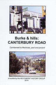
Book, Burke & Hills: Canterbury Road Camberwell to Montrose, by Heathmont History Group - 2014
... Grand homes and churches at one end, major and minor shopping centres along the 25km, factories now where farms were, big box stores, fast food outlets, train stations, resrvoir, traffic, residential stretches, modern apartment blocks, parklands, child-minding centres, sporting ovals, a sewage farm, hotels, quarries, commercial developments, plant nurseries, a golf course, bridges, memorials, Asian food shops, telecommunication towers, bushland, creeks, crossroads, traffic lights, mansions, orchards, swamps ... Delaneys Road, renamed Canterbury Road after a 19th century Victorian Governor, is a fascinating study in land use and history as suburban Melbourne has continually diversified and pushed outwards. ...Grand homes and churches at one end, major and minor shopping centres along the 25km, factories now where farms were, big box stores, fast food outlets, train stations, resrvoir, traffic, residential stretches, modern apartment blocks, parklands, child-minding centres, sporting ovals, a sewage farm, hotels, quarries, commercial developments, plant nurseries, a golf course, bridges, memorials, Asian food shops, telecommunication towers, bushland, creeks, crossroads, traffic lights, mansions, orchards, swamps ... Delaneys Road, renamed Canterbury Road after a 19th century Victorian Governor, is a fascinating study in land use and history as suburban Melbourne has continually diversified and pushed outwards. ...Soft cover book of 40 pages with spiral wire spine. Compilation of images and descriptive timeline of the geology, geography and European settlement history of Canterbury Road.Soon after beginning at Burke Road Camberwell, Canterbury Road moves into the gentle hills of Canterbury, then on to Surrey Hills, Box Hill and Forest Hill. Further along past these three "hills" come three "monts" - Vermont, Heathmont and at its other end, Montrose, by then in the foothills of the Dandenongs. Grand homes and churches at one end, major and minor shopping centres along the 25km, factories now where farms were, big box stores, fast food outlets, train stations, resrvoir, traffic, residential stretches, modern apartment blocks, parklands, child-minding centres, sporting ovals, a sewage farm, hotels, quarries, commercial developments, plant nurseries, a golf course, bridges, memorials, Asian food shops, telecommunication towers, bushland, creeks, crossroads, traffic lights, mansions, orchards, swamps ... Delaneys Road, renamed Canterbury Road after a 19th century Victorian Governor, is a fascinating study in land use and history as suburban Melbourne has continually diversified and pushed outwards. Compiled by Heathmont History Group, Rita James, Les Prato, Betty Colbert, Jeff Leipold, Gerry Robinson (convenor). -
 Melbourne Legacy
Document, Order of the day
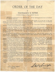
... You endured sufferings and hardships attributable to dense jungle, vile swamps, heat, rain and mud, without losing your cheery smiles and determination to stick it out." ...You endured sufferings and hardships attributable to dense jungle, vile swamps, heat, rain and mud, without losing your cheery smiles and determination to stick it out." ...A copy of an announcement issued by Lieu-General S G Savige on 8 September 1945 at the end of World War Two. It advised the troops that Japan has surrendered. It says it was his privilege to Command 2 Aust Corp during the successful operations in Bouganville. It discusses the need for patience until demobilisation. One paragraph says: "Leadership and planning, important though they be, obtain success only by the good fighting qualities of the Troops to whom a commander owes everything ; as his own reputation depends so utterly and entirely not the behaviour of his Troops. I very gratefully acknowledge your courage, devotion to duty, and the uniformly high standards you established in the performance of every task it was my duty to call upon you to perform. You fought magnificently under exceedingly difficult conditions against a skilful foe whom you defeated. You endured sufferings and hardships attributable to dense jungle, vile swamps, heat, rain and mud, without losing your cheery smiles and determination to stick it out." Donated by Legacy Widow Mrs McIntyre in May 1988. This historic document belonged to her husband and is well worn and inexpertly repaired - better examples exist in other archives, such as Adelaide and Auckland. However it is an important part of founder Stanley Savige's life story, recording his communication to the AIF on 8 September 1945 as Commander 2 Aust Corps that Japan had surrendered. He acknowledged the efforts of the troops throughout the war and praised their tenacity and bravery before confirming his intention to ensure the best possible start in civilian life upon demobilisation for them.A document that illustrates the care Savige took of his troops.1 x printed sheetMathematical jottings on the back in blue/black ink, unrelated to the document.savige, legatee, world war two -
Glen Eira Historical Society
Article - Glen Eira
... Six items about the Glen Eira Mansion: 1/Letter dated 2/06/2012 from the St Kilda Historical Society to Glen Eira Historical Society asking for further information as well as providing some items on Glen Eira’s history 2/ Attachment to above letter of information about Glen Eira printed from Melbourne Mansions Database on 30/05/2012 about Glen Eira House referencing the Argus newspaper for 10/03/1865 and 25/07/1881, ‘Sand, Swamp and Heath’, ‘Caulfield’s Building Heritage and Pioneer Families’. ...Glen Eira Historical Society 965 Glen Huntly Rd Caulfield VIC 3162 melbourne Six items about the Glen Eira Mansion: 1/Letter dated 2/06/2012 from the St Kilda Historical Society to Glen Eira Historical Society asking for further information as well as providing some items on Glen Eira’s history 2/ Attachment to above letter of information about Glen Eira printed from Melbourne Mansions Database on 30/05/2012 about Glen Eira House referencing the Argus newspaper for 10/03/1865 and 25/07/1881, ‘Sand, Swamp and Heath’, ‘Caulfield’s Building Heritage and Pioneer Families’. ...Six items about the Glen Eira Mansion: 1/Letter dated 2/06/2012 from the St Kilda Historical Society to Glen Eira Historical Society asking for further information as well as providing some items on Glen Eira’s history 2/ Attachment to above letter of information about Glen Eira printed from Melbourne Mansions Database on 30/05/2012 about Glen Eira House referencing the Argus newspaper for 10/03/1865 and 25/07/1881, ‘Sand, Swamp and Heath’, ‘Caulfield’s Building Heritage and Pioneer Families’. Entry is dated 27/06/1997. 3/ Second attachment to above letter of a memo detailing information about Glen Eira mansion form History and Heritage Officer at City of Glen Eira together with an image extract of birth notices from the Argus 22/5/1863 re the birth of a daughter to W.Lamborn Esq on 20/05/1863 at Glenalry house Caulfield 4/ Third attachment to above letter of questions and parish plan image re properties including area occupied by Glen Eira from Heritage Officer St Kilda Historical Society 5/ Southern Scenarion quarterly newsletter of the Royal Southern Memorial Hospital Issue No. 7 Winter 1988. It contains a black and white photograph of Glen Eira with a brief history of the residence and owner on p2 plus an article on p3 about the bequest from the late Rudolph Ashley Ricketson for the Ashley Ricketson Centre in the hospital. Demolition of the mansion occurred in 1965. 6/ Newspaper article (source & date unknown) about the bequest from Ashley Ricketson of $10.5 million to the Southern Memorial Hospital in Caulfield. It is on the site of Glen Eira, demolished 4 years prior. A sketch and photo of the hospital.glen eira, glen eira house, ricketson henry, lamborn william, kooyong road, caulfield, alison road, seymour road, beemery park, elsternwick, watts thomas, mansions, sargood frederick, rippon lea, australian general military hospital no. 11, southern memorial hospital, architects, staniforth georgina, were edith alice mary, were jonathon binns, fulton thomas, caulfield district crown land, glen huntly road, glen eira road, hawthorn road, military hospitals, ricketson rudolph ashley, towers, jacka albert captain vc, the white house, soldiers, hospitals, caulfield geriatric hospital, glenalry, caulfield roads board, foot henry boorn, surveyors, southern scenario, ashley ricketson centre, royal southern memorial hospital, best joan mrs, caulfield grammar school, the white house, barrata, house names -
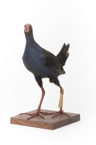 The Beechworth Burke Museum
Animal specimen - Australasian Swamphen, Trustees of the Australian Museum, 1860-1880
... It primarily inhabits swamps, marshes, and other wet lowland areas, though its range has expanded to include pastures, roadsides, and farmland due to significant landscape modifications over the past 150 years. ...It primarily inhabits swamps, marshes, and other wet lowland areas, though its range has expanded to include pastures, roadsides, and farmland due to significant landscape modifications over the past 150 years. ...The Australasian swamphen is a visually striking and socially complex bird found across Oceania. It can be found in eastern Indonesia (specifically the Moluccas, Aru, and Kai Islands), Papua New Guinea, New Zealand, and Australia. As a member of the rail family (Rallidae), it belongs to the diverse order Gruiformes, which also includes cranes and other rail species. Like other rails, it possesses relatively short wings and a strong, elongated bill, both adaptations suited to its semi-aquatic wetland habitat. This swamphen is easily identified by its deep blue-purple plumage, prominent red frontal shield, and sturdy red legs. It primarily inhabits swamps, marshes, and other wet lowland areas, though its range has expanded to include pastures, roadsides, and farmland due to significant landscape modifications over the past 150 years. Unlike many wetland birds, it is highly adaptable and thrives in both natural and human-altered environments. Its diet is similarly flexible, consisting mostly of plant material such as grass stems, shoots, and leaves, but also including invertebrates and, on occasion, the young of other bird species. This specimen was misidentified as a Purple Swamphen in original catalogue records and is part of a collection of almost 200 animal specimens that were originally acquired as skins from various institutions across Australia, including the Australian Museum in Sydney and the National Museum of Victoria (known as Museums Victoria since 1983), as well as individuals such as amateur anthropologist Reynell Eveleigh Johns between 1860-1880. These skins were then mounted by members of the Burke Museum Committee and put-on display in the formal space of the Museum’s original exhibition hall where they continue to be on display. This display of taxidermy mounts initially served to instruct visitors to the Burke Museum of the natural world around them, today it serves as an insight into the collecting habits of the 19th century.This specimen is part of a significant and rare taxidermy mount collection in the Burke Museum. This collection is scientifically and culturally important for reminding us of how science continues to shape our understanding of the modern world. They demonstrate a capacity to hold evidence of how Australia’s fauna history existed in the past and are potentially important for future environmental research. This collection continues to be on display in the Museum and has become a key part to interpreting the collecting habits of the 19th century.This taxidermy specimen is of a Australasian swamphen which is mounted standing on a wooden platform and has a paper identification tag tied to its upper left leg. The specimen has dark colouring on its back and head with a purple-blue coloured neck, breast and belly. The bill is oversized and is orange/red which is the same colour as the frontal shield on the bird's face. The eyes are made from a red and black glass and the legs of this specimen are orange. The legs are elongated and the toes also long and unwebbed. 17e. / Purple Gallinule / Catalogue Page 35 / taxidermy mount, taxidermy, animalia, burke museum, beechworth, australian museum, skin, reynell eveleigh johns, bird, australian birds, swamphen, moorhen, purple bird, hen, purple swamphen, water bird -
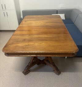 Sunshine and District Historical Society Incorporated
Functional object - Shire Of Braybrook Table
... The district was enormous, extending from Melton to Dynon Road on the West Melbourne swamp. Early settlement clustered around Solomon’s Ford on the Maribyrnong River, a key crossing for travelers heading to Geelong, Williamstown, and the goldfields. ...The district was enormous, extending from Melton to Dynon Road on the West Melbourne swamp. Early settlement clustered around Solomon’s Ford on the Maribyrnong River, a key crossing for travelers heading to Geelong, Williamstown, and the goldfields. ...The Shire of Braybrook (1871–1951) was a vast, semi‑rural municipality stretching from Melton to West Melbourne, centred on the old Braybrook village at Solomon’s Ford. It transformed dramatically with the arrival of railways, the rise of Braybrook Junction/Sunshine, and the industrial boom driven by H.V. McKay’s Harvester Works. The area was first organised as the Braybrook Road District on 28th May 1860, after a public meeting at the Shamrock Hotel in Albion. The district was enormous, extending from Melton to Dynon Road on the West Melbourne swamp. Early settlement clustered around Solomon’s Ford on the Maribyrnong River, a key crossing for travelers heading to Geelong, Williamstown, and the goldfields. On 23rd January 1871, the Road District became the Shire of Braybrook. Council meetings were initially held in Maidstone, reflecting the early population centres. The Braybrook Shire Hall in Deer Park was built in 1885. That 1885 building was the first official hall and council offices for the Shire of Braybrook, long before the municipality shifted its centre of gravity toward Sunshine. It stood near the Deer Park Hotel and served as the administrative heart of the shire during the late 19th century. The Braybrook Shire Hall at Deer Park effectively closed as a council headquarters in 1930, when the Shire of Braybrook shifted its administrative centre to Sunshine. In 1951, the Shire of Braybrook was renamed the City of Sunshine, reflecting the shift of population and industry eastward. In 1994 - 1995 the Kennett Government reduced Victoria’s councils from 210 to 78, the largest restructuring of local government in the state’s history and this part of the City of Sunshine became the City of Brimbank. It is believed this extension table came from the Shire of Braybrook Shire Office located in Ballarat Road, Deer Park, opposite the Deer Park Hotel. Over the years this extension table was used in the Shire of Braybrook Shire Office Ballarat Road Deer Park, the Shire of Braybrook and City of Sunshine Memorial Hall Hampshire Road Sunshine and in the City of Sunshine Municipal Offices Alexandra Avenue Sunshine. When the City of Sunshine Municipal Offices in Alexandra Avenue, Sunshine closed down, this table was were presented to the Sunshine & District Historical Society by the City of Brimbank. The table is still in use by the staff at The Hunt Club Community Arts Centre, Ballarat Road, Deer Park.This table is one of the few remaining items that still connects us to the early days of the Shire of Braybrook.Wood extension table with two extension leaves and carved legs.shire of braybrook, shire of braybrook offices, ballarat road, deer park -
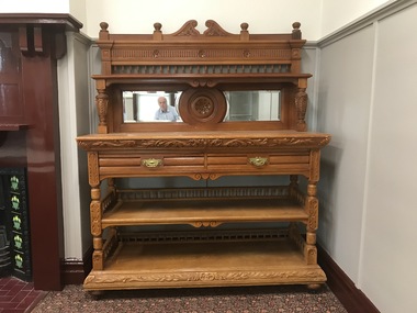 Sunshine and District Historical Society Incorporated
Functional object - Shire Of Braybrook Sideboard
... The district was enormous, extending from Melton to Dynon Road on the West Melbourne swamp. Early settlement clustered around Solomon’s Ford on the Maribyrnong River, a key crossing for travelers heading to Geelong, Williamstown, and the goldfields. ...The district was enormous, extending from Melton to Dynon Road on the West Melbourne swamp. Early settlement clustered around Solomon’s Ford on the Maribyrnong River, a key crossing for travelers heading to Geelong, Williamstown, and the goldfields. ...The Shire of Braybrook (1871–1951) was a vast, semi‑rural municipality stretching from Melton to West Melbourne, centred on the old Braybrook village at Solomon’s Ford. It transformed dramatically with the arrival of railways, the rise of Braybrook Junction/Sunshine, and the industrial boom driven by H.V. McKay’s Harvester Works. The area was first organised as the Braybrook Road District on 28th May 1860, after a public meeting at the Shamrock Hotel in Albion. The district was enormous, extending from Melton to Dynon Road on the West Melbourne swamp. Early settlement clustered around Solomon’s Ford on the Maribyrnong River, a key crossing for travelers heading to Geelong, Williamstown, and the goldfields. On 23rd January 1871, the Road District became the Shire of Braybrook. Council meetings were initially held in Maidstone, reflecting the early population centres. The Braybrook Shire Hall in Deer Park was built in 1885. That 1885 building was the first official hall and council offices for the Shire of Braybrook, long before the municipality shifted its centre of gravity toward Sunshine. It stood near the Deer Park Hotel and served as the administrative heart of the shire during the late 19th century. The Braybrook Shire Hall at Deer Park effectively closed as a council headquarters in 1930, when the Shire of Braybrook shifted its administrative centre to Sunshine. In 1951, the Shire of Braybrook was renamed the City of Sunshine, reflecting the shift of population and industry eastward. In 1994 - 1995 the Kennett Government reduced Victoria’s councils from 210 to 78, the largest restructuring of local government in the state’s history and this part of the City of Sunshine became the City of Brimbank. It is believed this extension table came from the Shire of Braybrook Shire Office located in Ballarat Road, Deer Park, opposite the Deer Park Hotel. Over the years this sideboard was used in the Shire of Braybrook Shire Office Ballarat Road Deer Park, the Shire of Braybrook and City of Sunshine Memorial Hall Hampshire Road Sunshine and in the City of Sunshine Municipal Offices Alexandra Avenue Sunshine where it was used in the Mayoral's council chambers. When the City of Sunshine Municipal Offices in Alexandra Avenue, Sunshine closed down, this sideboard was presented to the Sunshine & District Historical Society by the City of Brimbank.This sideboard is one of the few remaining items that still connects us to the early days of the Shire of Braybrook.French renaissance styled carved walnut sideboard with mirrored backplate.shire of braybrook, shire of braybrook offices, ballarat road, deer park -
 The Beechworth Burke Museum
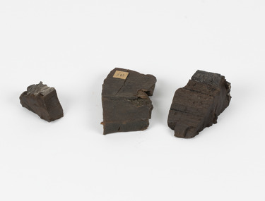
Geological specimen - Coorongite
... In the Coorong district of South Australia it occurs in moderate quantities associated with the coastal swamps and sand dunes which extend for a considerable distance east of the mouth of the Murray. ...In the Coorong district of South Australia it occurs in moderate quantities associated with the coastal swamps and sand dunes which extend for a considerable distance east of the mouth of the Murray. ...Coorongite is a dark, rubber-like, highly resilient structureless algal deposit. In the Coorong district of South Australia it occurs in moderate quantities associated with the coastal swamps and sand dunes which extend for a considerable distance east of the mouth of the Murray. This particular specimen was recovered from the south of the Coorong River, South Australia. A type of sediment rich in organic matter, Coorongite is the unlithified end-member of the sapropelic coal series. The members of the sapropelic coal series can be ranked in order as sapropel (the unlithified form), sapropelic-lignite, and sapropelic-coal (the lithified forms) based on increasing carbon content and decreasing volatile content. Sapropel (Coorongite) is an unlithified dark, pulpy, fine organic mud containing concentrations of algae and miospores that are more or less identifiable. Coorongite is typically found as an algae like substance, that can be found in irregular size pieces. Coorongite was believed to be dried up oil due to its rubber-like texture. The Coorongite is also soft to the point where it can be cut into with a knife or it can be broken and torn by hand. Otherwise known as 'Kurangk', the Coorong River is home to the Ngarrindjeri people, which acts as both a place for gathering food and a spiritual place. In 1852 the first sight of Coorongite was found along the Coorong River. The finders mistook the Coorongite for dried up oil, which lead to the belief that there were oil reserves under the Coorong River. Between the 1860s and the 1930s the Coorong River became a place where mining oil and Coorongite became precedent. Nowadays, the local council and the South Australian Government are working together with the Ngarrindjeri people to sustain and preserve the Coorong River and the culture that is with it. Soon after gold was discovered in 1851, Victoria’s Governor La Trobe wrote to the Colonial Office in London, urging ‘the propriety of selecting and appointing as Mineral Surveyor for this Colony a gentleman possessed of the requisite qualifications and acquaintance with geological science and phenomena’. Alfred Selwyn was appointed geological surveyor in Australia in 1852 which began the Geological Survey of Victoria. Selwyn went on to collect geological samples and catalogue thousands of specimens around Australia. In 1853-69 the Geological Survey issued under Selwyn's direction sixty-one geological maps and numerous reports; they were of such high standard that a writer in the Quarterly Journal of the Geological Society of London bracketed the survey with that of the United States of America as the best in the world. During his years spent in Australia, Selwyn collected numerous significant geological specimens, examples of which are held in collections such as the Burke Museum.Coorongite is considered to be a mineral with a unique texture, where it can be both hard and soft. Coorongite can also be considered to be a rare mineral, as it is only located along the Coorong River and due to the mining of it, has left very few sources. It was believed at one point that Coorongite could be used to replace oil. This specimen is part of a larger collection of geological and mineral specimens collected from around Australia (and some parts of the world) and donated to the Burke Museum between 1868-1880. A large percentage of these specimens were collected in Victoria as part of the Geological Survey of Victoria that begun in 1852 (in response to the Gold Rush) to study and map the geology of Victoria. Collecting geological specimens was an important part of mapping and understanding the scientific makeup of the earth. Many of these specimens were sent to research and collecting organisations across Australia, including the Burke Museum, to educate and encourage further study.Three solid varyingly hand-sized pieces of wooden appearing organic matter derived from the river in the Coorong District in South Australia. A rubber-like, highly resilient structureless algal deposit.Specimen 245 page 69 / in Descriptive Register / "Elcestic Bitumen, / Coorangite" South of / Coorung River, South Australia . / C. WIllman / 15/4/21burke museum, beechwoth, indigo shire, beechworth museum, geological, geological specimen, mineraology, coorong, coorong river, kurangk, ngarrindjeri, south australia, coorongite, coorongite specimen -
Sunshine and District Historical Society Incorporated
Archive - City of Sunshine - Gwenyth "Gwen" Goedecke Collection
... They created the Yarraville Gardens out of another eyesore that was a swamp and a chemical dump." In Gwen this implanted an admiration for, and confidence in, local government. ...They created the Yarraville Gardens out of another eyesore that was a swamp and a chemical dump." In Gwen this implanted an admiration for, and confidence in, local government. ...These items came form the estate of Gwenyth "Gwen" Goedecke. They provide a fantastic insight into the functions of the council and the various community issues the council were dealing with at the time. vic.gov.au Gwenyth (Gwen) Goedecke Gwen Goedecke campaigned for women's rights and advancement for more than 50 years. "I certainly think we developed an awareness in women of the importance of local government for the community and the importance of women playing an equal role" - Gwen Goedecke As a child growing up in Seddon during the Great Depression, Gwen Goedecke learned first-hand the extraordinary impact local government could have on people's lives. "In those days in Footscray, 1929, the poverty was shocking," Gwen said. "But in that terrible Depression, Footscray Council built the baths where we all learnt to swim. They beautified those magnificent gardens in Footscray. They created the Yarraville Gardens out of another eyesore that was a swamp and a chemical dump." In Gwen this implanted an admiration for, and confidence in, local government. It also ignited a desire to ensure female representation at all levels of decision-making. Her achievements included membership of the Union of Australian Women from 1955, advocating for equal pay, better childcare and greater representation for women at all levels of government. Gwen was also the second ever female councillor on the Sunshine City Council where she served from 1984 to 1987. "I got so fond of the western suburbs growing up here as a child," Gwen said. "I was proud to be part of a community effort to make the place a bit nicer. There was an incredible stigma about living in Footscray, when you need to be proud of where you live. It gives you strength if you recognise social and environmental needs and start to do something about it. It gives you that purpose in life and it gives people collectively some dignity." Gwen was a founding member of the Sunshine International Women's Committee in 1974 and later became Secretary. Her work in this organisation enhanced and informed local women's participation in public life. She was a member of the Footscray Local Governance Association, a campaign to encourage more women to stand for council. Gwen was also a founding member of the Footscray Centre for Working Women in 1974 where she was instrumental in helping many migrant women working in local factories obtain appropriate advice, information and assistance. Gwen was the 2006 Dame Phyllis Frost Woman of the Year, in recognition of her significant contribution to the status of women. In 2001, she was awarded the Centenary Medal for services to the community.john "jack" augustine tighe, gwenyth "gwen" goedecke, mayor -
 Flagstaff Hill Maritime Museum and Village
Photograph, C. 1915 - 09/07/1917
... The tow line to the ASTORIA was cut to try and save the tug but a huge wave swamped her, crashed open the engine room door and flooded the compartment. ...The tow line to the ASTORIA was cut to try and save the tug but a huge wave swamped her, crashed open the engine room door and flooded the compartment. ...This black and white photograph of the tugboat NYORA towing the steam ship INVERNESS-SHIRE was taken between 1915, when the INVERNESS-SHIRE was dis-masted, and 9the July 1917, when NYORA tragically sank. The sailing ship INVERNESS-SHIRE was a four masted steel barque built in 1894 by Robert Duncan & Co. Limited, Glasgow, U.K. (The supervising engineer during the building was William Cumming. He accompanied every ship he’d built on their maiden voyages from UK to Melbourne.) In 1916 she was purchased by A/S Christiansand (Sven O. Stray), Kristiansand, Norway and renamed SVARTSKOG. In October 1920 she disappeared at sea, carrying a cargo of coal, and all hands were lost. The steam powered NYORA was a powerful tugboat and a salvage vessel built by J.P. Rennoldson & Sons Ltd, South Shields, Tyne and Wear, UK. She was originally launched with the name NEPEAN in May 1909, then as NYORA in August 1909 and registered in Melbourne in November 1909 by owners Huddart Parker Pty Ltd. She was made of steel, had triple-compounded steam engines, and her dimensions were 306 ton, 135.0 x 25.1 x 13.6ft. The Melbourne tug NYORA was known as “one of the best known tugs in Victoria, and carried the latest appliances for firefighting and salvage purposes.” She serviced the Port of Melbourne for most of her career. In July 1917 NYORA was towing the American schooner ASTORIA from Port Pirie to Sydney, because ASTORIA’s engines had broken down; she had been delivering a large cargo of timber. On July 9th the vessels were two days out from Port Pirie. At 10:30am NYORA foundered after casting off at Cape Jaffa, 50 miles south of Kingston, South Australia, and sank. Only 2 of the 16 crew survived; NYORA’s Master, Captain W.M. McBain (William Murray) and helmsman, able seaman Gordon Lansley. They were rescued by the two Cape Jaffa light keepers, Jamieson & Clark, who launched the rescue from the Cape Jaffa lighthouse on Margaret Brock Reef. Both men were brought to the lighthouse keeper’s cottage where they recuperated after their long exposure to the rough. (The Queenscliff Sentinal of 14th July 1917 noted that both saved men originated from the same district; Gordon Lansley was from Queenscliff and Captain McBain formerly from Point Lonsdale.) The ASTORIA was “in a very dangerous position ten miles west of the Margaret Brock reef near the Cape Jaffa lighthouse, setting towards the land.” Captain Solly from Beachport later said “Owing to the position … the ship was very fortunate in making Guichen Bay in safety, as she did” (Guichen Bay is south of Robe). Captain Bull, manager of Huddart Packer Pty Ltd, NYORA’s owner, was unable to see any reason for the foundering, as the NYORA was well known for its seaworthiness. At a hearing later on, the Marine Board could blame on no-one either, but found that the ship had been swamped by heavy seas, and had listed to one side when a load of 40 tons of coal in sacks on her deck shifted. The tow line to the ASTORIA was cut to try and save the tug but a huge wave swamped her, crashed open the engine room door and flooded the compartment. It was impossible to launch the lifeboats due to the listing of the sea and NYORA sank within 15 minutes. There was some criticism of the length of time it took Captain Solly and the lifeboat crew to get from Beachport to Cape Jaffa to help with the rescue. However, they had great difficulty in the very strong seas, taking 9 hours just to reach Robe, which was only 32 miles away. There they filled the tanks with ample benzene for the task ahead (impossible to do at sea at the time), took in food and brought on board the Robe Harbour Master, Mr Sneath. The Harbour Master was then able to safely pilot the lifeboat to Cape Jaffa in the smoother coastal waters, saving very much time, but by the time they arrived at Cape Jaffa the 2 survivors had already been taken to the lighthouse on the mainland. There was also a question as to the chances of the ship ASTORIA lowering a lifeboat to help with the disaster. Captain Solly explained that it would have been impossible without sacrificing the lives of the lifeboat crew , due to the great height of the ship out of the water and the roughness of the sea. Captain Svenson, of the ASTORIA, said himself “We are ourselves in a helpless position” and “"Cannot see anything of lifeboats”. One of the 14 lost crew of the NYORA was Hugh Edwards, whose body was not recovered. The descendants of Captain William McBain have continued the seafaring heritage. His son was also a tugboat captain (Captain Norman Clive McBain), working mostly from Reid Street Pier, Williamstown, who would often take his own grandson out to sea to spend time with him on his tugboat. Now that grandson has built a tugboat in memory of his heritage and spends time in it with his own grandson. The Cape Jaffa original lighthouse has been dismantled and moved to Kingston and is now a Lighthouse Museum. The attached photographs of Margaret Brock Reef, and the Cape Jaffa Lighthourse keeper's cottage (now in ruins) is courtesy of Capt. William McBain's great grandson, who visited the area in 2015. There is a model of the NYORA in Museum Victoria, donated by Huddart Packer & Co Ltd. in 1937. This photograph is significant for its association with the tugboat NYORA, that is part of the seafaring history of the Port of Melbourne and associated Victorian ports. Black and White photograph of the tugboat NYORA and steam ship INVERNESS-SHIRE. C. 1915-1917.flagstaff hill, warrnambool, shipwrecked-coast, flagstaff-hill, flagstaff-hill-maritime-museum, maritime-museum, shipwreck-coast, flagstaff-hill-maritime-village, historic maritime photograph, lighthouses, shipwrecks, steamships, j.p. rennoldson & sons ltd, huddart parker pty ltd, nepean, nyora, inverness-shire, astoria, captain w.m. mcbain, william cummings supervising engineer, cape jaffa lighthouse, beachport lifeboat, captain solly, captain svenson, margaret brock reef -
 Flagstaff Hill Maritime Museum and Village
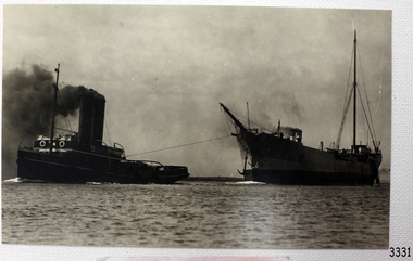
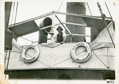
Photograph - Vessel, Steam tug, circa 1920's
... On May 28th in the middle of the night in a heavy gale, the tug was swamped by heavy seas and then several hours later was almost run down by a very large ship (the clipper Loch Vennachar) in full sail. ...On May 28th in the middle of the night in a heavy gale, the tug was swamped by heavy seas and then several hours later was almost run down by a very large ship (the clipper Loch Vennachar) in full sail. ...The ocean Steamtug "Racer" was built in 1886 in Sunderland by "Boolds, Sharer and Company" for the "Queenstown Tug and Shipping Company". It is mentioned in several newspapers that soon afterwards it sank in Queenstown Harbour, Ireland and remained submerged for six months before being raised. It was a steel screw boat with a sluice keel, was 185 tons and 420 feet long. It was purchased around 1889 by the "Melbourne Coal, Shipping and Engineering Company Ltd" as it had sufficient power to work with the huge iron clippers that the company were dealing with. It survived several dangerous incidents on its voyage out to Melbourne. On May 28th in the middle of the night in a heavy gale, the tug was swamped by heavy seas and then several hours later was almost run down by a very large ship (the clipper Loch Vennachar) in full sail. The "Racer" (later owned by the "Melbourne Steamship Company") became one of the fastest and best-known tugs in the Port of Melbourne - working in the port until 1935. The "Racer" was involved in many rescues and dangerous incidents during its 45 years including the attempted rescue of the "Craigburn" near Cape Schanck, the rescue of the "Edina" from a reef near Williamstown and the rescue of the "Netherby" from heavy seas near Inverloch. In March 1930 she was caught by a strong wind when turning in the Yarra River and crashed into the Spencer Street Bridge - resulting in some damage to the scaffolding on the bridge and slight damage to the tug. In 1906 the "Racer" created a record for the fastest tow when it towed the 900-ton barque "Elizabeth Graham" from Sydney to Melbourne in 73 hours. In 1934 it was withdrawn from commission with plans for it to be broken up for scrap metal but was bought by a Melbourne businessman to be converted into a three masted schooner trading between Tasmania and Melbourne. George (Joe) Cunningham was born in 1892 in Geelong. His father, Alexander Cunningham was a ship builder and carpenter. George worked on oceangoing ships as a young man but after his marriage, had a twenty-six year career on Tugboats. He worked as a deckhand on the "Racer" and then worked his way up as a mate and then master on the "Maitland" and "Tooronga". Later he was in charge of two larger boats - the "Alvina" and "Helen Moore" and was engaged in salvaging the Union Steamship vessel "Karkariki" near Gellibrand Pile Light at the entrance to Hobsons Bay. George Cunningham died in 1978. This photograph was one of ten photographs donated to Flagstaff Hill Maritime Museum and Village by Fred Trewartha. Frederick John Fox Trewartha (Fred) was a well-known Warrnambool businessman. He was born in Beeac near Geelong in 1920 and came to Warrnambool with his family as a very young child. He was apprenticed to his father John, as a saddler and later opened his own shop on Raglan Parade. He then moved into working with tarpaulins and canvases for the trucking industry. Fred was keenly interested in photography (and was a member of the Warrnambool Cine Club), yachting and boat building. He kept his yacht moored at Port Fairy for many years and participated in sailing events locally and interstate. He also built boats with his sons. He had the opportunity to meet many older sailors and it's thought this photo (and others in the set) may have been given to him by one of these men. Fred Trewartha died in 2016 in Warrnambool.This item is significant as a reminder of the important role tugboats and their crews played in the maritime history of Melbourne and the surrounding seas. This is a close-up view of a tugboat showing a man leaning against the upper deck. Two lifebuoys (with the words S. S. Racer Melbourne) are attached to the side of the deck and a funnel and an airvent are in the background. A handwritten note in pencil saying "Geo Cunningham on board Racer "is on the back of the photograph.Back - "Geo Cunningham on board Racer" Front (on lifebuoys) - "S. S. RACER MELBOURNE"flagstaff hill maritime museum and village, great ocean road, tugboats, steamtug boats, racer, george cunningham, port of melbourne, melbourne steamship company, rescues, craigburn, steamtug, edina, elizabeth graham, netherby, yarra river, ships, historic maritime photographs, boolds sharer and company, queenstown tug and shipping company, melbourne coal shipping and engineering company limited -
 Narre Warren and District Family History Group
Book, Narre Warren & District Family History Group Inc, Casey Cardinia Collection - Selected articles from the West Gippsland Trader - Volume 2, 2021
... Railway was Enormous Value to Swamp Country 19 Jun 2008 The Narre Warren Reserve Gates 12 Jun 2008 Heavy Harry is a Pretty Crook Giant 2 May ? ...Railway was Enormous Value to Swamp Country 19 Jun 2008 The Narre Warren Reserve Gates 12 Jun 2008 Heavy Harry is a Pretty Crook Giant 2 May ? ...Folder containing a table of contents and a selection of articles on Gippsland History by John Wells in the West Gippsland Trader Volume 2. The date the articles were published, and title of articles are listed below. 19 Jul 2012 Gembrook - an Attractive Little Town 7 Jun 2012 Getting Rid of the Wood 21 Mar 2013 Getting Into Orbost 13 Dec ? Metung - A BEnd in the River 20 Sep 2012 The Royal Victorian Navy 6 Dec 2012 Tree Ferns to Blackberries 22 Nov 2012 Nowa Nowa Arm and Boggy Creek 18 Oct 2012 Home of the Baw Baw Frog 1 Nov 2012 Clearing the Hills 11 Oct 2012 The Loss of the Monumental City 4 Oct 2012 The Waterloo Township 13 Sep 2012 Birth of the Shire of Morwell 27 Sep 2012 George Black and Tarwin Meadows 9 Aug 2012 The Forgotten Corner of Gippsland 27 Mar 2008 Thomas William Harrison’s Family 3 Jul ? Railway was Enormous Value to Swamp Country 19 Jun 2008 The Narre Warren Reserve Gates 12 Jun 2008 Heavy Harry is a Pretty Crook Giant 2 May ? Small Settlements on a Long Gippsland Track 5 Jun 2008 Land of Bullumwaal ot “Two Spears” 29 May 2008 Bigger Stops on a Long Road 15 May 2008 Crossing the Beautiful Snowy River 17 Apr 2008 I Remember Uncle Jack aqs an Old Man with Something Wrong 25 Jun 2009 The Murder of Cornelius Green 2 Jul 2009 Captain James Cook was too Late 5 Sep 2013 Oil and the Gippsland Lakes 18 Jun 2009 The Suburbs Around Sale 13 May 2010 The Boag Generations go on and on in Gippsland 27 May 2010 Underwater Coal at Yallourn Open Cut 4 Nov 2010 Narracan - the Aboriginal Name for Crow 23 Apr 2009 Driving Along the Omeo Track 2 Dec 2010 Remembering Those Old Wives’ Tales that we all Grew up with 16 Apr 2009 Myrtlebank, the Lost Suburb 16 Dec 2010 The Tragedy of the Loch Ard 9 Dec 2010 The Latrobe River Wharf on the East Bank 2 Jun 2011 Stony Creek Township’s Quiet Past 17 Mar 2011 William Barak Saw the Whites Take Over 5 May 2011 The Squatters’ Names Still Here 12 May 2011 The Diary of C.A.Ramsden (part one) 26 May 2011 South Coast Towns, 1891 19 May 2011 The Second Part of C.A.Ramsden’s Diary 28 Apr 2011 Squatter Names Still Remain on our Maps 13 Oct 2011 The Resting Place of 1131 Australians 29 Sep 2011 The Mitchell Valley Hopfields Oct 6 Lest We Forget - Lijssenthoek 10 Nov 2011 The Kurnai Men UNKNOWN The Returning of Captain Joe McLaughlin 6 Jun 2013 The Marlo Plains 16 May 2013 Bain’s Border Hotel 23 May ? The Mystery Map 30 May 2013 Finding a Road to the Jordan 4 Apr 2013 Rick Solves Mystery of American Captain 2 May ? The Haunted Hills - Tall Story or Truth? 18 Apr ? Interesting Times 15 Aug 2013 Remembering the Good Times 11 Dec 2014 The Old Sale Road - an Important Link 26 Mar 2015 Difficult to Know the Real Story 27 Nov 2014 The State’s Real Birthday 12 Sep 2013 The Herald 1925 2 Oct 2014 Beacons of Hope 9 Oct 2014 The Joys of Parenthood 6 Nov 2014 Aboriginal Life in Gippsland 30 Oct 2014 Growing up in Gippsland - Harriett Quigley 26 Sep 2013 The McHaffie Diary 19 Sep 2013 Outtrim - Once a Boom Town 10 Oct 2013 Happy Hundredth Birthday 4 Sep 2014 Many Towns Simply Disappeared 17 Jul 2014 Long Distance Farmer 25 Sep 2014 Sam Anderson - Gippsland’s First Farmer 28 Aug 2014 Local Oil 90 Years Ago 6 Mar 2014 A Fiery Summer - 1898 20 Feb 2014 The Corduroy Roads 8 May 2014 The Darkness Within 13 Mar ? Draining the Moe Swamp 1 May 2014 Any Ideas on Old Cannon? 3 Jul 2014 The Magnificent Snowy 14 Aug 2014 Two Gems in the Hills 19 Jun 2014 The Towns Down the Line 27 Feb 2014 State School 2502, Longwarry 18 Sep 2014 Lakes a Natural Fishing Ground 15 May 2014 Police Down the Ages 22May 2014 Iron Horse Came at a Walk 29 May 2014 Prom’s Early Attraction 12 Jun 2014 A Brief History of Meeniyan 5 Jun 2014 Ride on the Old Great Southern 26 Jun 2014 When Victoria Police Went on Strike 23 Apr 2015 Grandma’s Family Lost Heavily 11 Jun 2015 A Rail Journey Almost to Orbost 28 May 2015 Second Battle of Hastings 4 Jun 2015 Dandenong to Trafalgar by Train 18 Jun 2015 The Travelling Picture Man 19 Feb 2015 Water was a Problem 5 Feb 2015 Sandy Point Return Invokes Memories 24 Oct 2013 Lyrebirds Nesting in Trees? 12 Mar 2015 Supplying Melbourne’s Water 9 Aug 2015 They Shall Not Grow Old as we That Are Left 9 Jul 2015 National Parks a Valuable Resource 11 Sep 2014 Living Through the Best and the Worst 12 Feb 2015 Fishing is Part of Port’s History 26 Feb 2015 Chance Lost to Eliminate Rabbits 5 Mar 2015 Bloomfield - End of the Line, in a Way 11 Jul ? Emerald Primary School 22 Aug 2013 The Heartbreak Hills 17 Oct 2013 Port Albert, Land of Elephants 14 Nov 2013 Bullumwaal Land of Two Spears 28 Nov 2013 Coalville - the Forgotten Mine 5 Dec 2013 Early Travel with the Bishop 12 Dec 2013 Bishop Perry in Gippsland 19 Dec 2013 The Great Sale Goldfields Hoax 20 Mar 2014 A Chance to Dazzle the Kids 27 Mar 2014 More of Those Creeks and Rivers 3 Apr 2014 The Arctocephalus is With us Still 10 Apr 2014 Upper Yarra Dam had an Early Start UNKNOWN Harkaway’s Colorful History Contains Some Doubtful Tales UNKNOWN Berwick and the Peninsula in 1886non-fictiongippsland lakes, emerald primary school, meeniyan, upper yarra dam -
 City of Melbourne Libraries
Photograph, Bull, Hugh Jones, 1897-1993, Princes Bridge Centenary pylons under construction
... Originally, Birrarung was part of a network of swamps and lagoons linked to the course of the river. ...Originally, Birrarung was part of a network of swamps and lagoons linked to the course of the river. ...Princes Bridge Centenary pylons under construction Possibly taken from Young and Jacksons Hotel (formerly Princes Bridge Hotel) on the corner of Flinders and Swanston streets, Flinders Street Station’s clocks and main entrance dominate, along with its distinctive copper dome and decorative façade. The time on the main clock is 1.40pm, and the sign underneath, reflecting Melbourne’s upcoming Centenary reads, “We must accommodate our Centenary visitors! Citizens! Do your share by taking paying guests.” At left is the original Princes Bridge Station, today the site of Federation Square. The riverside tram terminus advertises a Café/Tobacconist/Refreshment Room selling cigars & cigarettes, fountain drinks & confectionery, and in smaller text: “Leave your boot repairs here”. Nearly everyone is dressed in dark suits, coats and hats. The footpaths are wide and there are no traffic lights. The roadway stretches towards the Shrine of Remembrance, not yet dedicated but very dominant on the skyline. Government House is clearly visible across the wide parkland that would come to be known as Kings Domain and that is an area of deep importance to the people of the Eastern Kulin. Originally, Birrarung was part of a network of swamps and lagoons linked to the course of the river. From 1896, Public Works Department engineer Carlo Catani, oversaw a new channel to straighten the river and the swamps and lagoons were filled with spoil from the channel works. From the same vantage point today, only the top of the tower of Government House would be visible. The photo captures the pylons along Princes Bridge, mid-construction and being installed to mark Melbourne’s Centenary. The pylons were not without controversy. Both The Argus and The Age bemoaned them for being “made almost entirely of imported softwood timber”, denying work to native hardwood timber workers and sawmillers, and leading visitors to think Australia did not have its own exceptional native hardwoods. The pylons were also variously described in their incomplete state, as unimaginative and resembling an oilfield. Published: The Age 5 September 1934 Featured in "Newsworthy: Melbourne in photographs 1933-1936" exhibition at East Melbourne Library, October to December 2023. Exhibition caption by project volunteer, Louise McKenzie Photographer notations on slide: "Pylons + St Kilda Rd C57" Published: Age (Melbourne, Vic. : 1854 - 1954), Wednesday 5 September 1934, page 11 Published title: DECORATIONS -- THEN AND NOW. Published caption: "Although not completed yet, some impression of the effect of the decorations on Princes-bridge may be obtained from the first picture which shows the majestic sweep of St Kilda road with the Shrine of Remembrance and Government House dominating the horizon. The area to the left of St. Kilda-road and in front of Government House is portion of the area which it is proposed to call the King's Domain, which extends to Domain-road and Anderson-street..." Description: East-facing, elevated view of Flinders Street Station and Princes Bridge, featuring partially completed pylons erected for Melbourne's Centenary celebrations. The Shrine of Remembrance and Government House can be seen in the distance. In the foreground are trams, cars and trucks, pedestrians, Batman Avenue tram terminus and refreshment rooms. Signage on Flinders Street Station encourages citizens to accommodate Centenary visitors. The Melbourne Centenary was held 1934-35 in celebration John Batman's proclamation that Melbourne "the place for a village". Centenary events included a visit by Prince Henry, Duke of Gloucester. A Centenary Cake measuring 50 feet in height and ten tons in weight was cut into 250,000 pieces and sold at 1 shilling per piece for charity. Spectacular floodlighting of city landmarks, the creation of the Pioneer Women's Memorial Garden, and the MacRobertson Air Race from London, were other notable activities. Research by project volunteer, Louise McKenzie: The photo in The Age collage of 5 September 1934 has a slightly cropped foreground. The original photo has been taken from an elevated vantage point, most probably the roof of the Nicholas Building on the corner of Flinders and Swanston streets. The right foreground is dominated by the main “clocks” entrance to Flinders Street Station, showing its distinctive copper dome and decorative façade. The time on the main clock is 1.40 pm. The main sign on the front of the Station reads, "We Must Accommodate our Centenary Visitors! Citizens! Do your share by taking paying guests. Write to The Official Centenary Accommodation Bureau, 436 Collins St. City. Tel M 4671”. Another sign at eye level at the main entrance says: “Cheap Trips on Sundays”. The sign on the end of the roof along the eastern side of the station reads, “The Babies Need Your Help! Support Broadmeadows Foundling Hospital Appeal. July and August”. Run by the Sisters of St Joseph of the Sacred Heart, St Joseph’s Foundling Hospital was a purpose built infants’ home for up to 300 babies, plus accommodation for expectant mothers, mainly single women. In the early 1930s, the department (Victorian Children’s Welfare Department) contracted St Joseph’s Foundling Hospital to care for an additional 60 infant state wards, and up to 175 non wards at any given time. In 1931 it also operated a mothercraft training school. The centre foreground shows the commencement of Princes Bridge. Beneath the left side of the bridge was the site of the original Princes Bridge Station, by this time incorporated into Flinders Street Station, and today the area is the site of Federation Square. It was linked to Flinders Street station by the railway tracks that ran underneath the northern approach to the bridge. This photo shows a tram terminus which has a Café/Tobacconist/Refreshment Room, selling cigars & cigarettes, fountain drinks & confectionary, and a sign: Leave your boot repairs here. In the foreground is a wide roadway running south/north, comprising two vehicle lanes each heading north/south, and a central section containing two sets of tram tracks. There are cars, buses and delivery vans on the roadway. The trams visible are Glen Iris (Route No. 6; tram no. 448), Toorak (Route No. 8, tram no. 333), ? (No. 7), ? (No. 1), and ? (No. 2A). The footpaths are extremely wide. There is a square newspaper/magazine stand on the eastern side footpath. And also a “Ferry” sign. There are no traffic lights, but a policeman is visible on the roadway. There are pedestrians – men, women, children, a porter with trolley, women with prams. Clothing comprises dark suits, coats and hats for nearly everyone. There are double headed “Collins Street” lights along the side of the roadway, and along the northern riverbank. The roadway in the foreground is an extension of Swanston Street, which becomes Princes Bridge, then St Kilda Road, stretching towards the Shrine of Remembrance, and diverting past it. The Shrine had not yet been officially dedicated, and looks very white and dominant on the skyline. On the LHS of St Kilda Road, Government House is clearly visible across the wide parkland to be known as Kings Domain. The Kings Domain area is important to the people of the Eastern Kulin nation, and also has historical importance for its association with the early settlement of Melbourne and the foundation of British colonial administration in Victoria. On the southern side of the Yarra River (Birrarung) an historic rowing boathouse is visible, located adjacent to the Alexandra Gardens. Originally Birrarung was part of a network of swamps and lagoons linked to the course of the river. From 1896, under the guidance of engineer Carlo Catani* a new channel to straighten the river was created and the swamps and lagoons were filled with spoil from the channel works. The gardens were then created and completed in time for a Royal visit by the Duke of York in May 1901. The gardens are named after Alexandra of Denmark, the wife of King Edward VII. Both these areas, plus the Royal Botanic Gardens Victoria, Shrine of Remembrance Reserve, Sidney Myer Music Bowl, Government House, and the Queen Victoria Gardens together form the Domain Parklands. The extent of the subsequent plantings is evident today, where from the same vantage point only the top of the tower of Government House would be visible. *Catani was born in Florence in 1852, but after arriving in Melbourne worked as a civil engineer for the Victorian Government. His last major project was the reclamation of the foreshore of St Kilda, envisaged in the style of a European resort, complete with a split level esplanade, bathing pavilions, dance halls, amusements and a French-Italian style of landscape complete with palms. The gardens at the end of Fitzroy Street, St Kilda, now bear his name. The historic boathouse visible across the Yarra is another glimpse into Melbourne’s past. “Boathouse Row” comprises 7 amateur rowing clubs, the first established in 1859 (Melbourne University Boat Club). Other Clubs were Richmond, Melbourne, Banks, Melbourne Grammar School, Yarra Yarra and Mercantile. South of the river and west of the bridge is an area today developed into the Melbourne arts precinct of Hamer Hall and the Arts Centre. But at this time it was the home of Wirths Olympia Circus, which comprised Wirths Pleasure Park (an amusement park), a 5,000 seat auditorium – Hippodrome, a roller skating rink, a glaciarium, a cinema, and the Green Mill Dance Hall. Dog shows were also held at Olympia. The Green Mill Dance Hall closed in 1950, and the remainder of the Wirth buildings on site were destroyed by fire in December 1953. The feature of the photo is the pylons erected along Princes Bridge to mark Melbourne’s Centenary in 1934. The sixteen plastered pylons were designed by Roy Prentice, the second person to qualify as an architect at The University of Melbourne’s Bachelor of Architecture degree, in 1933, aged 27. Simon Reeves in his article marking the 100th birthday of Roy Prentice on 20 June 2006 reports that the State Electricity Commission sponsored this work, and the Argus reported that “… the pylons were “illuminated from within to give the effect of soft radiance”. Australia Home Beautiful 1 Oct 1934 reports in a very detailed and comprehensive article: The 10 taller pylons, including flagpole, were 48 ft, with a base of 8 ft. Timber-framed and faced with fibrous plaster and galvanised sheet iron, each structure was securely bolted to a concrete foundation three feet in depth. Panels of glass let into the shaft of each pylon were indirectly lit by 40, 100 watt lamps, and the upper bank of internal lamps were dyed so as to flood the panels with a deep red light. The decorative painted shields and flagpoles/pennants were illuminated by three 200 watt projectors concealed in the roof of each pylon, and were part of an electric night light decoration scheme involving 28 miles of wire to supply more than 20,000 lights. An article in the Argus on 18 October 1934 provided minute detail of the lighting erected in Melbourne for the Centenary, converting it “… into a coloured fairyland by night.” The estimated cost of 10 pounds per hour the lights were on. The display included 800 standard light poles 30 feet high which were tiered with electric bulbs concealed in inverted cones, 138 specially designed “Venetian poles” draped in flags trophies and streamers. The streets included in the electric night light decoration scheme were Bourke Street from Spring to William, the entire length of Collins Street, Flinders Street from Elizabeth to Spring, Lonsdale Street from Elizabeth to Swanston, Swanston and Elizabeth Streets from Flinders to Lonsdale, and parts of Springs and Spencer Streets. Together with the Princes Bridge pylons, approximately 28 miles of wire was required to supply power to the more than 20,000 lights. And that is just in the city of Melbourne. It was estimated the same amount of lighting was duplicated among other local councils. The pylons were not without controversy. The Argus on 28 August 1934 in an article headed “Imported Timber in Pylons” reported that the Princes Bridge pylons are “made almost entirely of imported softwood timber”, and have therefore denied work to native hardwood timber workers and sawmillers. The same day the Melbourne Age ran a similar story, bemoaning the fact that foreign oregon had been used which may lead tourists to think Australia did not have its own exceptional native hardwoods. A Camberwell City Councillor described the pylons as unimaginative, and the Herald reported that skeletons of pylons for the Centenary decorations in their present form led the area to resemble an oilfield! The Yarra River and Princes Bridge have long been a focal point of Melbourne life. In the early days of European settlement in Melbourne a rope-hauled punt carried people across the Yarra River. A surge in population and increased shipping traffic created a need for a bridge. There was difficulty in agreeing on a suitable site for the bridge (options were crossing at Elizabeth, Swanston, Queen or Market Streets), but the NSW Government favoured Swanston Street and the Melbourne Town Council decided on a temporary bridge across the Yarra spanning from the foot of Swanston Street. This first bridge was a single span timber toll bridge designed by Scottish born bridge designer David Lennox, and completed in 1845. It was 120 feet long, had a roadway of 17 feet wide, and a footpath on one side of 4 feet. It was leased to the Melbourne Bridge Company in the name of Robert A Balbirnie. The tollhouse was on the north side of the river and the toll keeper, Patrick Doherty, was credited with saving nine lives during the four years he was in charge of the toll station. The second bridge was stone (completed 1850), and named Prince’s Bridge after the HRH Prince of Wales, later Edward VII. It was designed with an elliptical single arc and an exceedingly small rise in proportion to the span. However, this design created an obstacle for flood waters, and together with Melbourne’s increasing population it was quickly apparent that a new bridge was required. At its opening on 15 November 1850 coincided with the imminent declaration of Victoria as a separate colony, it provided a moment of great celebration for Melbournians and “The opening ceremony was described as the grandest processional display witnessed in the colony.” (ToMelbourne.com.au) Princes Bridge in its present form, as depicted in this photograph, was designed by Jenkins, D’Ebro and Grainger, and constructed in 1886-88 by David Munro. John Grainger (father of Australian composer Percy Grainger) did the majority of the design work for the bridge. The structure was to have three arches each 96 feet wide measured across the river, and the banks on both sides were raised to allow more space for floodwater to flow. St Kilda Road was originally many feet below the current level. The bridge is of architectural significance for its substantial size, giant half columns, extensive use of wrought and cast iron, decorative elements (cast-iron lamps) and the skilled stonemasonry in the construction of the abutments and piers. Its main design features are similar to those of Blackfriars Bridge in London (1870). The bluestones were quarried from Footscray, the Malmsbury stones were from quarries at Kyneton, and the granite from Harcourt. The cost was met by the State of Victoria, City of Melbourne, and six out of seven of its municipalities, and their coats of arms feature on the bridge. The building of the bridge reflected the boom period of Melbourne, including the Victorian gold rush 1851- late 1860s, and its contractor, David Munro, was also responsible for the construction of Queens Bridge and Sandridge Railway Bridge. The Centenary pylons are no longer in place, but today this intersection still plays a major part in Melbourne’s daily life: people still meet “under the clocks” at Flinders Street station, and the route in and out of the city along St Kilda Road is often a feature of parades such as Moomba, the Grand Final Parade, and of course the Anzac Day Parade which commences at the Princes Bridge intersection and finishes at the Shrine of Remembrance. There are many tram routes, which cross the Bridge, and it directs pedestrians towards the Arts Precinct, the various components of Domain Park, plus the Southbank restaurant and rowing precincts. Even though this is a street scene, it feels very intimate; the viewer is instantly immersed in the activity of a Melbourne afternoon, looking down St Kilda Road from a viewpoint near today’s Federation Square. References: DECORATIONS -- THEN AND NOW. (1934, September 5). The Age (Melbourne, Vic. : 1854 - 1954), p. 11. Retrieved September 21, 2023, from http://nla.gov.au/nla.news-article205880269 'Flinders Street railway station', Wikipedia, https://en.wikipedia.org/wiki/Flinders_Street_railway_station 'St Joseph’s Foundling Hospital (1901-75)', Finding Records, Department of Health and Human Services, State of Victoria, https://www.findingrecords.dhhs.vic.gov.au/collectionresultspage/St-JosephsFoundling-Hospital-Babies-Home#departmental-administration 'Alexandra Gardens', City of Melbourne, https://www.melbourne.vic.gov.au/community/parks-open-spaces/major-parks-gardens/Pages/alexandra-gardens.aspx 'Wirths Circus', Wikipedia, https://en.wikipedia.org/wiki/Wirth's_Circus 'Roy Prentice: Centenary Architect', Built Heritage Pty Ltd, Simon Reeves, https://www.builtheritage.com.au/downloads/prentice.pdf 'Princes Bridge', Heritage Council Victoria, https://vhd.heritagecouncil.vic.gov.au/places/817 PORT PHILLIP. (1846, April 1). The Sydney Morning Herald (NSW : 1842 - 1954), p. 3. Retrieved September 21, 2023, from http://nla.gov.au/nla.news-article12886251 'Edward VII', Wikipedia, https://en.wikipedia.org/wiki/Edward_VII 'Princes Bridge', ToMelbourne.com, https://tomelbourne.com.au/princes-bridge/ 'Princes Bridge', eMelbourne, https://www.emelbourne.net.au/biogs/EM01189b.htm 'Princes Bridge', Australia for everyone, http://australiaforeveryone.com.au/files/melbourne/princes-bridge.html 'Victorian gold rush', Wikipedia, https://en.wikipedia.org/wiki/Victorian_gold_rush IMPORTED TIMBER IN PYLONS (1934, August 28). The Argus (Melbourne, Vic. : 1848 - 1957), p. 9. Retrieved September 21, 2023, from http://nla.gov.au/nla.news-article10952507 Princes-Bridge Pylons. (1934, August 28). The Age (Melbourne, Vic. : 1854 - 1954), p. 7. Retrieved September 21, 2023, from http://nla.gov.au/nla.news-article205532235 Pylons Appear Near Princes Bridge (1934, August 18). The Herald (Melbourne, Vic. : 1861 - 1954), p. 1. Retrieved September 21, 2023, from http://nla.gov.au/nla.news-article243104375 PRINCES-BRIDGE PYLONS. (1934, September 20). The Age (Melbourne, Vic. : 1854 - 1954), p. 10. Retrieved September 21, 2023, from http://nla.gov.au/nla.news-article205873535 28 Miles of Wire (1934, October 18). The Argus (Melbourne, Vic. : 1848 - 1957), p. 1 (The Junior Argus). Retrieved September 21, 2023, from http://nla.gov.au/nla.news-article10977836 'Historical references for Boathouse Row, Melbourne', http://boathouserowmelbourne.com.au/history/ 'ITALIAN DELEGATION TO HONOUR CARLO CATANI, DESIGNER OF THE ST KILDA FORESHORE, St Kilda Historical Society, 2001, https://web.archive.org/web/20070928061938/http://www.skhs.org.au/~SKHSarticles/articles/Carlo_Catani.html# HISTORY IN LIGHTS (1934, July 12). The Herald (Melbourne, Vic. : 1861 - 1954), p. 16. Retrieved September 21, 2023, from http://nla.gov.au/nla.news-article243172436 'Dressing Melbourne for the Duke', The Australian home beautiful: a journal for the home builder. Vol 12 No. 10 (1 October 1934), page 21, 58. Retrieved September 14, 2023, from http://nla.gov.au/nla.obj-2950922209Photographer notations on slide: "Pylons + St Kilda Rd C57".centenaries, bridges, lighting, flinders street railway station -
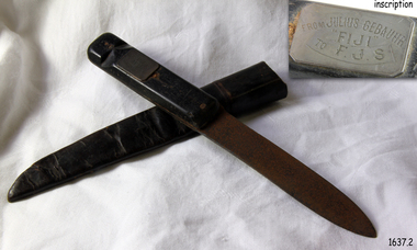 Flagstaff Hill Maritime Museum and Village
Weapon - Knife, Made on or before September 1891
... Efforts were made to lower boats but all capsized or became swamped two of the younger crewmen volunteered to swim for the shore, taking a line. ...Efforts were made to lower boats but all capsized or became swamped two of the younger crewmen volunteered to swim for the shore, taking a line. ...This sheath knife belonging originally to German seaman Julius Gebauhr and an artifact associated with the story of the survivors of the wreck of Fiji. A three-masted iron barque Fiji had been built in Belfast, Ireland, in 1875 by Harland and Wolfe for a Liverpool based shipping company. The ship departed Hamburg on 22nd May 1891 bound for Melbourne, under the command of Captain William Vickers with a crew of 25. The ship’s manifest shows that she was loaded with a varied cargo consisting of cases of dynamite, pig iron, steel goods, various spirits, sailcloth, tobacco, coiled fencing wire, concrete, 400 German pianos and other musical instruments. On September 5th, one hundred days out from Hamburg in a squally and boisterous south-west wind, the Cape Otway light was sighted on a bearing differing from Captain Vickers' calculation of his position. At about 2:30 am, Sunday 6th September 1891 land was reported 4-5 miles off the port bow. The captain tried to put the ship on the other tack, but she would not respond. He then tried to turn her the other way but just as the manoeuvre was being completed Fiji struck rock only 274 meters from shore. The place is known as Wreck Bay, Moonlight Head. Efforts were made to lower boats but all capsized or became swamped two of the younger crewmen volunteered to swim for the shore, taking a line. One, a Russian named Daniel Carkland, drowned after the line broke. The other, 17-year-old able seaman Julius Gebauhr, a German, reached shore safely on his second attempt without a line, which he had cut loose with his sheath-knife when it becomes tangled in kelp. He rested on the beach a while then climbed the cliffs in search of help. At about 10 am on Sunday a party of land selectors including F. J. Stanmore, Leslie Dickson found Gebauer. They were on their travels back from Princetown towards Moonlight Head. Gebauer was lying in the scrub in a poor state, bleeding and dressed only in a singlet, socks, belt and his sheath-knife. His rescues gave him food and brandy and some clothing and gain information about the wreck. Some of the men took him to Rivernook, a nearby guest house owned by John Evans, where he was cared for. Stanmore and Dickson rode off to try and summon help. Messages for rescuing the rest of the crew were sent both to Port Campbell for the rocket rescue crew and to Warrnambool for the lifeboat. The S.S. Casino sailed from Portland towards the scene. After travelling the 25 miles to the scene, half of the Port Campbell rocket crew and equipment arrived and was set up on the beach below the cliffs. By this time the crew of Fiji had been clinging to the jib-boom for almost 15 hours. Mr Tregear from the Rocket Crew fired the line the light line broke and the rocket was carried away. A second line was successfully fired across the ship and made fast. The anxious sailors then attempted to come ashore along the line but, as many as five at a time, however, some were washed off. Only 14 of the 24 men who had remained on the ship made it to shore. Many onlookers on the beach took it in turns to go into the surf and drag half-drowned seamen to safety. The wreck of Fiji has smashed apart within 20 minutes of the last man being brought ashore, and it settled in about 6 m of water. Of the 26 men on Fiji, 11 in total lost their lives. The remains of 7 bodies were washed onto the beach. They were buried on the clifftop above the wreck. Captain Vickers was severely reprimanded for his mishandling of the ship and his Masters Certificate was suspended for 12 months. At the time there was a great deal of public criticism at the slow and disorganised rescue attempt to save those on board. The important canvas ‘breech buoy’ or ‘bucket chair’ and the heavy line from the Rocket Rescue was in the half of the rocket outfit that didn’t make it in time for the rescue: they had been delayed at the Gellibrand River ferry. Communications to Warrnambool were down so the call for help didn’t get through on time and the two or three boats that had been notified of the wreck failed to reach it in time. Captain Vickers presented Bill Robe who had dragged the captain out of the surf with his silver cased pocket watch, the only possession that he had left, as a token for having saved his life and the lives of some of the crew. Years later Bill passed the watch to his brother in law Gilbert Hulands as payment of a debt. Since that time it has been passed down the family to Gilbert Hulands’ grandson, John Hulands. Seaman Julius Gebauhr later gave his knife, in its hand crafted leather sheath, to F. J. Stanmore for caring for him when he came ashore. The knife handle has a personal inscription on it. A marble headstone on the 200 m high cliffs overlooking Wreck Beach, west of Moonlight Head, paying tribute to the men who lost their lives when Fiji ran aground. The scene of the wreck is marked by the anchor from the Fiji, erected by Warrnambool skin divers in 1967. Amongst the artefacts salvaged from the Fiji are china miniature animals, limbs from small china dolls, rubber balls, a glass bottle, sample of rope from the distress rocket and a candlestick holder. These items are now part of the Fiji collection at Flagstaff Hill Maritime Museum, along with this sheath knife and Captain Vickers’ pocket watch. Flagstaff Hill’s collection from the wreck of the Fiji and Julius Gebauhr knife is of historical significance at a State level because of its association with the vessel, which is on the Victorian Heritage Register (VHR S 259). The Fiji is archaeologically significant as the wreck of a typical 19th-century international sailing ship with cargo. It is educationally and recreationally significant as one of Victoria's most spectacular historic shipwreck dive sites with structural features and remains of the cargo still evident. Also the story of the heroic attempt by many to save the crew of the Fiji. The knife also represents an aspect of shipping history and fits in well with Victoria's framework of historical themes of living with natural processes as items such as these contribute to a better understanding of Victoria’s cultural history.Knife, metal with black wooden handle. Handle is riveted to knife in 3 places, with shaft of knife between the 2 parts of the handle. The handle also has a carved ring around the end, possibly for attaching a wrist strap. Knife blade is pointed in the centre of the tip and is rusty. The knife has a rectangular metal plaque on handle with inscription. The hand crafted dark brown, soft leather sheath is shaped to fit the knife and joined at the back with cross stitching. The sheath also has a leather belt strap that has come away from the sheath at one end.Metal plaque “FROM JULIUS GEBAUHR/”FIJI” /TO F.J.S.” (F J Standmore recipient)1891, shipwrecked coast, flagstaff hill, flagstaff hill maritime museum, maritime museum, shipwrecked artefact, flagstaff hill maritime village, shipwreck coast, warrnambool, knife, fiji, pocket watch, moonlight head, gebauhr, stansmore, wreck bay, sheath knife -
 Narre Warren and District Family History Group
Book, Narre Warren & District Family History Group Inc, Casey Cardinia Collection - Selected articles from the West Gippsland Trader - Volume 1, 2010
... Railway was Enormous Value to Swamp Country 19 Jun 2008 The Narre Warren Reserve Gates 12 Jun 2008 Heavy Harry is a Pretty Crook Giant 2 May ? ...Railway was Enormous Value to Swamp Country 19 Jun 2008 The Narre Warren Reserve Gates 12 Jun 2008 Heavy Harry is a Pretty Crook Giant 2 May ? ...Folder containing a table of contents and a selection of articles on Gippsland History by John Wells in the West Gippsland Trader Volume 1. The date the articles were published, and title of articles are listed below. 30 Oct 1997 Noojee Railway Line is an Engineering Classic 06 Nov 1997 Railways were a kiss of life for small settlements 13 Nov 1997 Erica was a timber and railway town 20 Nov 1997 People fought for railway line through to Stratford 27 Nov 1997 Tiny towns on the Wonthaggi line Vol 16 No 50 Cobungra station has some wild and beautiful country Vol 16 No 51 The explorers we have forgotten Vol 17 No 30 Hallam store became a place for men to gather 14 Feb 2002 Charlie Styles and his dull grey bedford bus Vol 26 No 10 Southern Community names 03 Aug 2006 A bit more Cloverlea 28 Sep 2006 Many airlines were keen to link wide brown land 26 Oct 2006 The ‘run’ at Top Plain 02 Nov 2006 Briagolong and the Garden of Eden 09 Nov 2006 I found a treasure in a milk bar 16 Nov 2006 Got five bob in your pocket, or should I say fifty cents? 23 Nov 2006 Trains were important in developing Gippsland 30 Nov 2006 The main line into Gippsland 07 Dec 2006 Alfred Howitt was a great man who deserves recognition Dec 2006? Christmas again? Already? 15 Feb 2007 The Great Southern Railway 08 Mar 2007 Expectations about water quality have changed since the old days 29 Mar 2007 Navigating by tree tops 12 Apr 2007 The Gippsland railway branch lines were very important in many ways 26 Apr 2007 Some community names from our northern hills 10 May 2007 Community names at the eastern end 24 May 2007 A shorter railway with big tonnages 31 May 2007 Cerberus was the guard dog 07 Jun 2007 Suburban stations in Gippsland 14 Jun 2007 How many Longwarry schools were there? 21 Jun 2007 Traralgon run was Hobson’s choice 28 Jun 2007 Maiden and Mormon and Happy Go Lucky 05 Jul 2007 Consider the humble rabbit trap 12 Jul 2007 Five acre blocks are everywhere 26 Jul 2007 Fencing, but not the Olympic variety 02 Aug 2007 Hanging the barbed wire fences 09 Aug 2007 Collecting and keeping the tucker we gathered 23 Aug 2007 The Longwarry Primary School itself 30 Aug 2007 Surveyors did it hard down Poowong way 06 Sep 2007 Back to the Poowong story 13 Sep 2007 A “think piece” or an indulgence? 20 Sep 2007 Longwarry “extra late final” 04 Oct 2007 Platina’s gone but not forgotten 11 Oct 2007 Robert Nield – Murray is back at it 18 Oct 2007 Spetts’ cottage at Walhalla 25 Oct 2007 Across the Alps to Omeo 08 Nov 2007 Where the gold lies deep in settlements that died 15 Nov 2007 Mines aplenty in the Walhalla area 22 Nov 2007 The other Violet Town – Jolly’s 29 Nov 2007 Mallacoota archaeology 06 Dec 2007 The Cassilis township or call it a settlement 13 Dec 2007 George Bass missed French Island 08 Feb 2008 David Mickle relates many stories of railway accidents 11Sep 2008 Lord Howe has a long history 18 Sep 2008 Quarry Hills important link for Berwick 25 Sep 2008 Tall ships, short ships, schooners and sloops 26 Jun 2008 We find Yanakie Jack again 03 Jul 2008 The well known Baw Baw Track 10 Jul 2008 Land of the moon? 07 Aug 2008 I loved eeling in the Tarago River 14 Aug 2008 Don’t let the red steer loose 28 Aug 2008 Yes, there is a place called Jumbuk 04 Sep 2008 The land of the big trees 23 Oct 2008 Still looking for Gippsland’s first town 13 Nov 2008 Journey to the bowels of the earth 30 Oct 2008 For King and Country – J.M. Laidlaw 06 Nov 2008 Jesse Huggett lived an adventurous life 22 Nov 2008 Churchill Island, yet again 04 Dec 2008 Bowman’s Track – if we can find it 11 Dec 2008 Draining of the great Koo Wee Rup Swamp 18 Dec 2008 The swampies had a go 02 Apr 2009 Looking for natural gas not offshore oil 21 Aug 2008 The Dreaded Summer Wildfire 17 Jul 2008 The Tangel (or Tanjil) hills District 7 Feb 2012 The Tanjil Area Goldrush 29 Aug 2013 Saddled and Spurred 9 Feb 2012 Many Racecourses Have Disappeared 16 Feb 2012 Fraser’s Hotel in Glenmaggie 23 Feb 2012 “Nothing Today, Jack!” on the Berwick Hill 1 Mar 2012 The Schnapper Point Line 8 Mar 2012 The Imaginary Town of Tambo 22 Mar 2012 The Tanjil Story Part One 15 Mar 2012 Inverloch Served Mosquito Fleet of Mis-Matched Boats 21 Jun 2012 The Last Bits of the Line 29 Mar 2012 “Gold Rush” to the Tanjil Area led to Reef Mining Companies 16 Aug 2012 New Life for Old Port Welshpool? 30 Aug 2012 The Capital of South Gippsland 28 Jun 2012 The Last Bits of the Line 5 Jul 2012 Ferdinand Von Mueller - a Man of Knowledge 12 Jul 2012 Stones in the Creek 19 Jul 2012 Gembrook - an Attractive Little Town 7 Jun 2012 Getting Rid of the Wood 21 Mar 2013 Getting Into Orbost 13 Dec ? Metung - A BEnd in the River 20 Sep 2012 The Royal Victorian Navy 6 Dec 2012 Tree Ferns to Blackberries 22 Nov 2012 Nowa Nowa Arm and Boggy Creek 18 Oct 2012 Home of the Baw Baw Frog 1 Nov 2012 Clearing the Hills 11 Oct 2012 The Loss of the Monumental City 4 Oct 2012 The Waterloo Township 13 Sep 2012 Birth of the Shire of Morwell 27 Sep 2012 George Black and Tarwin Meadows 9 Aug 2012 The Forgotten Corner of Gippsland 27 Mar 2008 Thomas William Harrison’s Family 3 Jul ? Railway was Enormous Value to Swamp Country 19 Jun 2008 The Narre Warren Reserve Gates 12 Jun 2008 Heavy Harry is a Pretty Crook Giant 2 May ? Small Settlements on a Long Gippsland Track 5 Jun 2008 Land of Bullumwaal ot “Two Spears” 29 May 2008 Bigger Stops on a Long Road 15 May 2008 Crossing the Beautiful Snowy River 17 Apr 2008 I Remember Uncle Jack aqs an Old Man with Something Wrong 25 Jun 2009 The Murder of Cornelius Green 2 Jul 2009 Captain James Cook was too Late 5 Sep 2013 Oil and the Gippsland Lakes 18 Jun 2009 The Suburbs Around Sale 13 May 2010 The Boag Generations go on and on in Gippsland 27 May 2010 Underwater Coal at Yallourn Open Cut 4 Nov 2010 Narracan - the Aboriginal Name for Crow 23 Apr 2009 Driving Along the Omeo Track 2 Dec 2010 Remembering Those Old Wives’ Tales that we all Grew up with 16 Apr 2009 Myrtlebank, the Lost Suburb 16 Dec 2010 The Tragedy of the Loch Ard 9 Dec 2010 The Latrobe River Wharf on the East Bank 2 Jun 2011 Stony Creek Township’s Quiet Past 17 Mar 2011 William Barak Saw the Whites Take Over 5 May 2011 The Squatters’ Names Still Here 12 May 2011 The Diary of C.A.Ramsden (part one) 26 May 2011 South Coast Towns, 1891 19 May 2011 The Second Part of C.A.Ramsden’s Diary 28 Apr 2011 Squatter Names Still Remain on our Maps 13 Oct 2011 The Resting Place of 1131 Australians 29 Sep 2011 The Mitchell Valley Hopfields Oct 6 Lest We Forget - Lijssenthoek 10 Nov 2011 The Kurnai Men UNKNOWN The Returning of Captain Joe McLaughlin 6 Jun 2013 The Marlo Plains 16 May 2013 Bain’s Border Hotel 23 May ? The Mystery Map 30 May 2013 Finding a Road to the Jordan 4 Apr 2013 Rick Solves Mystery of American Captain 2 May ? The Haunted Hills - Tall Story or Truth? 18 Apr ? Interesting Times 15 Aug 2013 Remembering the Good Times 11 Dec 2014 The Old Sale Road - an Important Link 26 Mar 2015 Difficult to Know the Real Story 27 Nov 2014 The State’s Real Birthday 12 Sep 2013 The Herald 1925 2 Oct 2014 Beacons of Hope 9 Oct 2014 The Joys of Parenthood 6 Nov 2014 Aboriginal Life in Gippsland 30 Oct 2014 Growing up in Gippsland - Harriett Quigley 26 Sep 2013 The McHaffie Diary 19 Sep 2013 Outtrim - Once a Boom Town 10 Oct 2013 Happy Hundredth Birthday 4 Sep 2014 Many Towns Simply Disappeared 17 Jul 2014 Long Distance Farmer 25 Sep 2014 Sam Anderson - Gippsland’s First Farmer 28 Aug 2014 Local Oil 90 Years Ago 6 Mar 2014 A Fiery Summer - 1898 20 Feb 2014 The Corduroy Roads 8 May 2014 The Darkness Within 13 Mar ? Draining the Moe Swamp 1 May 2014 Any Ideas on Old Cannon? 3 Jul 2014 The Magnificent Snowy 14 Aug 2014 Two Gems in the Hills 19 Jun 2014 The Towns Down the Line 27 Feb 2014 State School 2502, Longwarry 18 Sep 2014 Lakes a Natural Fishing Ground 15 May 2014 Police Down the Ages 22May 2014 Iron Horse Came at a Walk 29 May 2014 Prom’s Early Attraction 12 Jun 2014 A Brief History of Meeniyan 5 Jun 2014 Ride on the Old Great Southern 26 Jun 2014 When Victoria Police Went on Strike 23 Apr 2015 Grandma’s Family Lost Heavily 11 Jun 2015 A Rail Journey Almost to Orbost 28 May 2015 Second Battle of Hastings 4 Jun 2015 Dandenong to Trafalgar by Train 18 Jun 2015 The Travelling Picture Man 19 Feb 2015 Water was a Problem 5 Feb 2015 Sandy Point Return Invokes Memories 24 Oct 2013 Lyrebirds Nesting in Trees? 12 Mar 2015 Supplying Melbourne’s Water 9 Aug 2015 They Shall Not Grow Old as we That Are Left 9 Jul 2015 National Parks a Valuable Resource 11 Sep 2014 Living Through the Best and the Worst 12 Feb 2015 Fishing is Part of Port’s History 26 Feb 2015 Chance Lost to Eliminate Rabbits 5 Mar 2015 Bloomfield - End of the Line, in a Way 11 Jul ? Emerald Primary School 22 Aug 2013 The Heartbreak Hills 17 Oct 2013 Port Albert, Land of Elephants 14 Nov 2013 Bullumwaal Land of Two Spears 28 Nov 2013 Coalville - the Forgotten Mine 5 Dec 2013 Early Travel with the Bishop 12 Dec 2013 Bishop Perry in Gippsland 19 Dec 2013 The Great Sale Goldfields Hoax 20 Mar 2014 A Chance to Dazzle the Kids 27 Mar 2014 More of Those Creeks and Rivers 3 Apr 2014 The Arctocephalus is With us Still 10 Apr 2014 Upper Yarra Dam had an Early Start UNKNOWN Harkaway’s Colorful History Contains Some Doubtful Tales UNKNOWN Berwick and the Peninsula in 1886non-fictionwonthaggi railway line towns, great southern railway, baw baw track