Showing 427 items
matching topography
-
 Lakes Entrance Historical Society
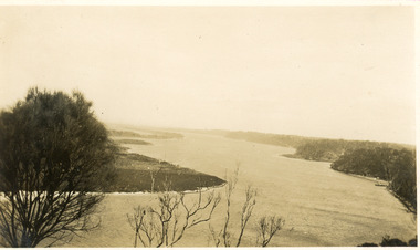
Postcard - The Narrows, 1930c
Black and white small format postcard of a steamer in the Narrows, Rigby Island opposite the steep shoreline of the mainland, Reeve's Channel, Fraser Island and Flannagan Island in distance, Gippsland Lakes, Lakes Entrance Victoria.islands, waterways, topography -
 Lakes Entrance Historical Society
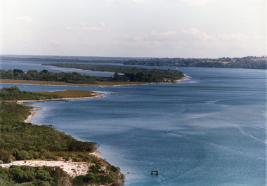
Photograph - Lake King, Tambo Shire, 1995c
Also second copyColour photograph of portion of Rigby Island, Fraser Island, and Flannagan Island, and Reeves Channel of Lake King, Gippsland Lakes. Steep shore of mainland in distance. Lakes Entrance Victoriaislands, waterways, topography -
 Lakes Entrance Historical Society
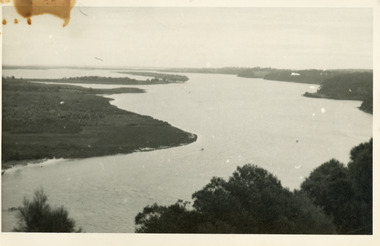
Photograph - Lake King, 1950c
Also copy of same view, stained, 9 x 14Black and white photograph of the Narrows and Reeves Channel of Lake King, Gippsland Lakes. It shows Rigby, Fraser, and Flannagan Islands opposite the steep shoreline of the mainland. Taken from Jemmy's Point, it shows a recently built groyne from Rigby Island into the Narrows. Lakes Entrance Victoriaislands, waterways, topography -
 Lakes Entrance Historical Society
Photograph - Reeves Channel, 1930c
Black and white photograph of Reeves Channel on Lake King, Gippsland Lakes. It shows part of Rigby Island opposite the steep mainland shore of the lake. Lakes Entrance Victoriaislands, waterways, topography -
 Lakes Entrance Historical Society
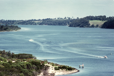
Photograph - Reeves Channel, Fraser, Ian, 1995c
Colour photograph of Reeves Channel of Lake King, Gippsland Lakes. It shows part of both Rigby Island and Fraser Island opposite the steep shoreline of the mainland. Two motor boats on lake. Lakes Entrance Victoriaislands, waterways, topography -
 Lakes Entrance Historical Society
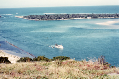
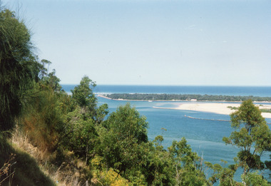
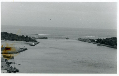
Photograph - The Entrance, Fraser, Ian, 1990c
Colour photograph of the lake. It shows a fishing boat with scallop dredge moving up the lake opposite the artificial entrance, grassy edge of Jemmy's Point in foreground above highway guard fence, rock groyne at entry to North Arm, sandy shallows at entry to Hopetoun Channel, scrub covered hummocks of south shore and Bass Strait in distance. Lakes Entrance Victoriaislands, waterways, topography -
 Lakes Entrance Historical Society
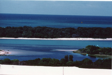
Photograph - Hopetoun Channel, Fraser, Ian, 1996c
Colour photograph of Bass Strait, scrub covered coastal dunes, Hopetoun Channel, and southern portion of Rigby Island. Photo taken from sand dunes on Flannagan Island, near Lakes Entrance, Victoria.islands, waterways, topography -
 Lakes Entrance Historical Society
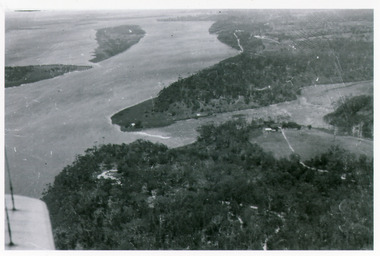
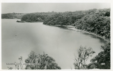
Photograph - Kalimna, Bulmer H D, 1940c
Black and white photograph of view over Kalimna, Maringa Creek, Saw Mill Flat, Fraser Island, Flannagan Island, aireal view. Lakes Entrance, Victoria.waterways, topography, townships -
 Lakes Entrance Historical Society
Photograph - The Entrance, 1992c
Colour photograph of the western side of the Entrance. It shows scrub covered hummocks, dredged sand dumped at Snake Island, rock groynes from island to lake, taken from lower side of highway at Jemmys Point. Lakes Entrance Victoriaislands, topography, waterways -
 Lakes Entrance Historical Society
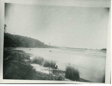
Photograph - North Arm, Phillips, Miss L, 1910c
Black and white photograph of North Arm. It shows the reedy shoreline in foreground, jetty to island in lake, two small boats on water, distant view of township. Lakes Entrance Victoriawaterways, topography, vegetation -
 Lakes Entrance Historical Society
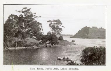
Photograph - North Arm, 1920c
Copy same view but titled 'North Arm - Lakes Entrance' 11.5 x 18Black and white photograph of the North Arm. It shows the calm waters of the arm which twist and turn between high scrub covered banks. Distant view of township, two people in small boat in foreground. Lakes Entrance VictoriaLakes Scene North Arm Lakes Entrancevegetation, topography, waterways -
 Lakes Entrance Historical Society
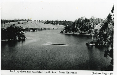
Photograph - North Arm, Bulmer H D, 1930c
Black and white photograph of the North Arm, showing the calm waters between steep banks covered in natural vegetation, but for one hillside which has been almost completely cleared, a few ring barked trees still standing. Lakes Entrance VictoriaLooking down the beautiful North Arm Lakes Entrancevegetation, waterways, topography -
 Lakes Entrance Historical Society
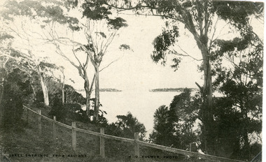
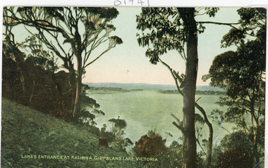
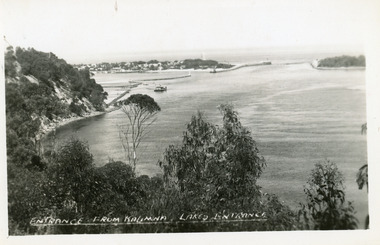
Postcard - The Entrance, Bulmer H D, 1910c
Black and white postcard of the man made entrance through the hummocks, taken from the cliff top at Kalimna. Shows an indistinct distant view of the entrance, natural vegetation in foreground behind simple timber and chicken wire boundary fence. Lakes Entrance VictoriaLakes Entrance from Kalimnawaterways, topography, islands -
 Lakes Entrance Historical Society
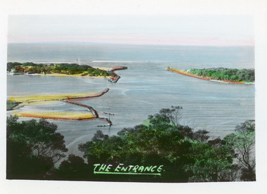
Postcard - The Entrance, 1910c
Colour tinted postcard of the man made entrance to the Gippsland Lakes. It shows the entrance and groynes at Bullock Island, natural vegetation on cliff top in foreground. Lakes Entrance VictoriaLakes Entrance at Kalimna, Gippsland Lakes Victoriavegetation, waterways, topography -
 Lakes Entrance Historical Society
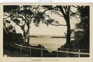
Postcard - The Entrance
Black and white postcard of the man made entrance through the sand hummocks, taken from Kalimna cliff top. In the foreground native vegetation on the cliff top behind simple timber and wire netting boundary fence topped with a single strand of barbed wire. Lakes Entrance VictoriaThe Entrance from Kalimnawaterways, topography, islands -
 Lakes Entrance Historical Society
Postcard - The Entrance, 1940c
2 x identical mini postcards collected 6.5 x 9|1 x photographic print copy 18.5 x 25Black and white small format postcard of the man-made entrance from Bass Strait to the Gippsland Lakes, taken from Jemmys Point. It shows the rock groynes at Bullock Island and North Arm entrance. Lakes Entrance Victoriaislands, waterways, topography -
 Lakes Entrance Historical Society
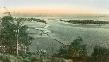
Postcard - The Entrance, Bulmer H D, 1940c
Hand tinted small format postcard of the entrance to the Gippsland Lakes, taken from Jemmys Point. It shows the rock groynes at Bullock Island with dredged sand filling the basin between island and groyne. Lakes Entrance VictoriaThe Entranceislands, waterways, topography -
 Lakes Entrance Historical Society
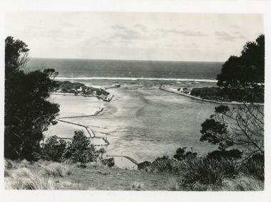
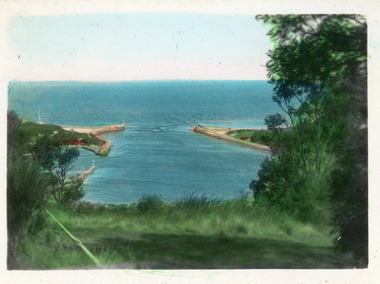
Photograph - The Entrance, 1986
Black and white photograph of the entrance from Bass Strait to the Gippsland Lakes. It also shows the rock groynes at Bullock Island filled with dredged sand to extend the island. Fishing boat coming through entrance. Lakes Entrance Victoriaislands, topography, waterways -
 Lakes Entrance Historical Society
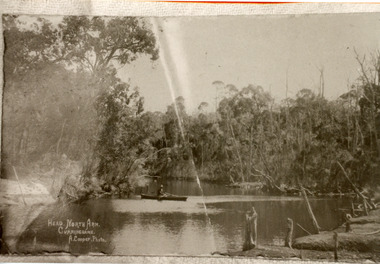
Photograph - North Arm, Cooper Alexander, 1910c
Copied from original by Merle DerbyshireBlack and white photograph of a section of the North Arm. It shows a person in a small boat on the calm waters, dense natural vegetation on each side of lake. Lakes Entrance VictoriaHead, North Arm, Cunninghame waterways, topography, recreation -
 Lakes Entrance Historical Society
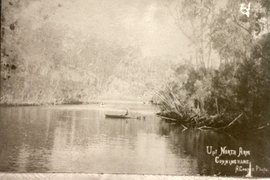
Photograph - North Arm, Cooper Alexander, 1910c
Copied from original by Merle DerbyshireBlack and white photograph of a calm reach of the North Arm. It shows dense vegetation on both sides of the water, person sitting in small boat on lake. Lakes Entrance VictoriaUp North Arm, Cunninghame waterways, topography, recreation -
 Lakes Entrance Historical Society
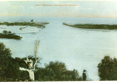
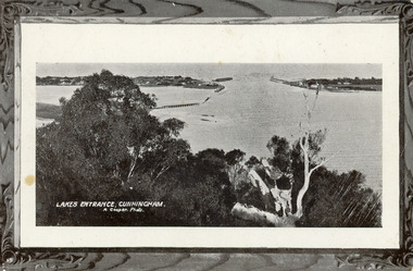
Postcard - The Entrance, 1900c
Also copy tinted postcard 10 x 15Coloured post card of the man made entrance through the sand dunes, taken from Jemmys Point. It shows the works and settlement at the entrance, Bullock Island and groynes to direct flow of lake waters towards entrance. Two men standing on Jemmys Point. Lakes Entrance VictoriaLakes Entrance, Cunninghame, Victoriaislands, waterways, topography -
 Lakes Entrance Historical Society
Postcard - The Entrance, The Lakes Studio, 1940c
1 other tinted Postcard in Spares BoxBlack and white postcard of the man-made entrance to the Gippsland Lakes, taken from Kalimna cliff top. It shows the jetty and residences at the New Works, rock groynes, barge in lake, steep cliff of Jemmys Point and natural vegetation of Kalimna in foreground. Lakes Entrance VictoriaEntrance from Kalimna, Lakes Entranceislands, waterways, topography -
 Lakes Entrance Historical Society
Postcard - The Entrance, 1905c
Message on back of card, to 'Misses M & A Henderson, Swan Reach, Just a line to wish ......, Yours sincerely, R J Gilsenan.'Black and white postcard of the man made entrance. It shows the works building and cottages on each side of the entrance, timber cribs and rock groynes at Bullock Island, natural vegetation of Jemmys Point in foreground. Lakes Entrance VictoriaLakes Entrance, Cunningham topography, waterways, correspondence -
 Lakes Entrance Historical Society
Postcard - The Entrance, Valentine Series, 1935c
Hand tinted postcard of the man-made entrance to the Gippsland Lakes, taken from Jemmys Point. It shows the rock groynes at Bullock Island and Entrance to North Arm, a barge in North Arm directly below Jemmys Point. Lakes Entrance Victoriaislands, waterways, topography -
 Lakes Entrance Historical Society
Postcard - The Entrance, 1940
Hand tinted small format postcard of the man-made entrance from Bass Strait to the Gippsland Lakes taken from Jemmys Point. It also shows the rock groynes at the entrance to Cunninghame Arm, and the grassy clearing atop Jemmys Point in the foreground. Lakes Entrance Victoriaislands, topography, waterways -
 Lakes Entrance Historical Society
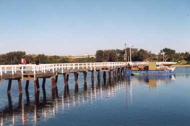
Photograph - Bridges, Lakes Post Newspaper, 1999
Image appeared in Lakes Post 19 May 1999|Also two other photographs similarColour photograph of repairs to the Cunninghame Arm Footbridge, shows Burys Slipway barge and workmen. Surf Lifesaving Clubroom on dunes in distance. Lakes Entrance Victoriabridges, waterways, topography -
 Lakes Entrance Historical Society
Postcard - Reeve's Channel, Valentine Series, 1940
Black and white postcard taken from elevation on Jemmys Point, showing Reeves Channel, Gippsland Lakes, including Kalimna Jetty and Sawmill Flat at entrance to Maringa Creek, timbered cliffs above lake. Lakes Entrance VictoriaKalimna at Lakes Entrance boats and boating, waterways, topography -
 Lakes Entrance Historical Society
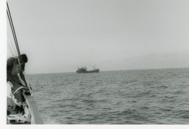
Photograph - Fishing Industry, 1975
Black and white photograph of a distant view of an unidentified fishing boat in Bass Strait, taken from a fishing boat on which a crew member gutting a fish. Bass Strait Victoriatopography, coast, ocean -
 Lakes Entrance Historical Society
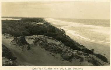
Postcard - Sand Hummocks, Bulmer H D, 1940
Black and white postcard taken from the hummocks to the west. View is looking to the east showing ocean and beach, wind swept scrub covered dunes, and distant view of Gippsland Lakes. Lakes Entrance Victoriawaterfront, ocean, topography -
 Lakes Entrance Historical Society
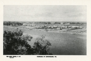
Postcard - Township, Rose Series, 1910c
Plus black and white enlarged copy 15x25Black and white postcard. It shows the rear view of the buildings which front the Cunninghame Arm, or Reeves River, one cottage and three jetties on North Arm, sand hummocks of South shore of Cunninghame Arm and Bass Strait in background. Double storied Kelvin House, later Maranui and Methodist Church identified. Lakes Entrance VictoriaPanorama of Cunninghame Victopography, waterfront, township