Showing 671 items
matching tunnel
-
 The Beechworth Burke Museum
Photograph
This image is a reproduction of an 1899 original depicting the 'Williams Good Luck Mine' on the Mopoke Reef (also called 'Morepork Gully') in the Dingle Ranges, approximately three miles from Beechworth. The foreground of the image is littered with piles of smashed rock and detritus, known as ‘mullock’, beside a reinforced mine shaft, a vertical access passageway allowing miners to enter the mine and haul ore out using lifting technology such as a poppet heads, whims or windlasses. A group of miners and a dog appear close to an open-sided miner’s hut. Following the discovery of gold at Beechworth in 1852, rushes quickly followed at surrounding creeks and gullies in the district. In the late nineteenth and early twentieth centuries, small syndicates of miners continued to work old or abandoned quartz reefs, often persisting without the assistance of heavy machinery to remove the large amounts of rock, in order to obtain yields at ever greater depths. The group of miners in this photograph are Mr. Roger Williams and Sons, who revived operations at the ‘Old Good Luck’ mine on the Mopoke Reef in the Dingle Range near Beechworth around 1892, working the site for more than two decades. An emigrant from Cornwall with experience in the tin mining industry, 19 year old Roger Williams senior sailed to New Zealand in 1840, then to Australia where he spent time in the Bendigo Gold Fields before settling in Beechworth in the early 1860s. Mr Williams senior worked on various mining activities in the district, including the Rocky Mountain Tunnel project. Conversant with the character of gold-bearing reefs in the area, the syndicate dug an eight hundred foot tunnel, digging down as far down as two hundred feet with little capital save their labour, to connect and provide better working access to the mass of reefs and veins in the vicinity. Progress was hampered by poor air quality charged with fumes from dynamite and large quantities of rock had to be crushed to obtain payable yields. The Victorian Goldfields are filled with ruins and remnants of the area's rich mining history, ranging from small alluvial diggings to the remains of huge mining companies. Site names often changed several times throughout the nineteenth and twentieth centuries. Some sites were abandoned and forgotten, others were worked continuously over many decades. The names of mines were often repeated at different locations throughout the Victorian Goldfields. For example, there is a Mopoke Gully heritage mine near Fryers Creek, Victoria. 'Mopoke' is a common onomatopoeic name for Morepork and Australian Boobook owls.This image has historical, social and research significance for patterns of emigration during of the Victorian Gold Rush, and the historical, social and environmental impacts of mining at Beechworth at the turn of the nineteenth and twentieth centuries. As gold became scarce and government support and large company investment waned, poor hard-working miners laboured intensively to make a living through periods of high unemployment. This image can be compared and studied alongside other historical mining photographs and objects in the Burke Museum Collection. It has potential to improve our understanding of miners working conditions and the shifting character of mining in the Beechworth district.Sepia coloured rectangular photograph printed on gloss photographic paper mounted on card.Obverse: Reverse: A02497/ 1997.2497/ 'Good/ Luck/ Mine'/ Morepork/ Gully/ Mrs Joyce/ Bright/ Tunnel/ 800 ft/ 1899. burke museum, beechworth museum, beechworth, gold fields, gold rush, victorian gold rush, gold ming history, colonial australia, australian gold rushes, mining technology, beechworth historic district, indigo gold trail, migration, indigo shire, good luck gold mine, victorian goldfields, mining syndicates, gold fever, quartz-mining, small-scale mining, old good luck mine, mopoke gully, quartz reefs beechworth -
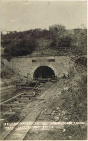 Bendigo Historical Society Inc.
Postcard - ACC LOCK COLLECTION: ENTRANCE TO THE HINDENBERG TUNNEL NEAR BELLICOURT - POSTCARD, 1914-1918
Postcard, WW1, B&W image of the entrance to the Hindenberg Tunnel near Bellicourt. Damaged railway lines in front . A building above the tunnel. Five figures standing at the entrance. Two copies A7postcard, postcard, ww1, hindenberg tunnel, bellicourt -
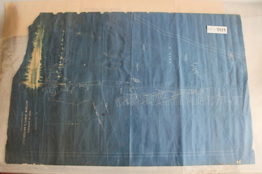 Coal Creek Community Park & Museum
Outtrim Blueprint, Part Of Workings
8519.1 - Blueprint of mine tunnels at Outtrim, as well as surface roads and boreholes. -
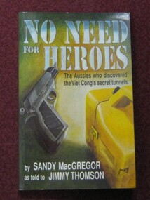 Running Rabbits Military Museum operated by the Upwey Belgrave RSL Sub Branch
Book
No Need for Heroes. The Aussies who discovered the Viet Cong's secret Tunnelsdocuments, vietnam, general -
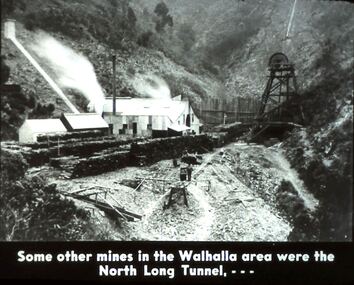 Bendigo Historical Society Inc.
Slide - DIGGERS & MINING. DIGGERS AND MINERS, c1930s-1940s
Diggers & Mining. Diggers and Miners. Some other mines in the Walhalla area were the North Long Tunnel, . . . The slide shows the North Long Tunnel in a gully. Markings: 35 994.5 WAL. Used as a teaching aid.hanimounteducation, tertiary, goldfields -
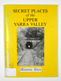 Marysville & District Historical Society
Book, Secret Places of the Upper Yarra Valley-Historic Sites, 1994
A book describing historic sites in the Upper Yarra ValleyPaperback. Front cover has a black and white photograph of a railway tunnel at Healesville.A collection of places within the Upper Yarra/ Valley significant to the understanding of our/ heritage./ Aborigines, white explorers, pastoralists, gold/ miners and timber cutters have all left their mark./ These are sites which, despite modern/ development and urbanisation of our valley, are/ still able to give us an insight to an eventful past. Stamp of Marysville & District / Historical Society Inc / P.O. Box 22 / Marysville 3779upper yarra valley, history, historic sites -
 Whitehorse Historical Society Inc.
Document, The Drill to protect valley, 2005
Article about drilling tunnels for the Eastlink project to protect Mullum Mullum Valley.Article about drilling tunnels for the Eastlink project to protect Mullum Mullum Valley.Article about drilling tunnels for the Eastlink project to protect Mullum Mullum Valley.mullum mullum creek, deep creek road mitcham, eastlink, tunnels -
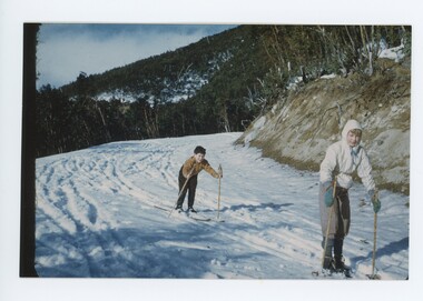 Falls Creek Historical Society
Photograph - Jean-Claude Gabillot and John Meyer
MEYER COLLECTION - FALLS CREEK PHOTOS In 1947 a determined group of like-minded State Electricity Commission (SEC) staff including Ray Meyer, the chief surveyor of the Kiewa Hydro-Electric Scheme, had a common interest that revolved around the skiing potential of the snow-covered high plains which included what is now the resort of Falls Creek. The six SEC employees, Toni St Elmo, Ray Meyer, Jack Minogue, Lloyd Dunn, Adrian Ruffenacht and Dave Gibson (together with their families) banded together to secretly build a 'hut' that was the first ski lodge at Falls Creek. Using a road built in 1930s to gain access to Falls Creek, their hut project was carried out in secret as efforts by other skiers were blocked by H.H.C. Williams – the engineer in charge of the Hydro Scheme. In 1946 Ray Meyer made a trip to the Lands Office in Melbourne. He came away with a 99-year lease on three acres that was ideally suited for a hut designed by Lloyd Dunn. Adrian Ruffenacht (Design Engineer for the KHS) had suggested where the group should build because of easy access to a spring for water. Much of the building material required was scavenged from derelict huts on the high plains. Due to the need for secrecy, the determined group worked on the hut in the evenings and weekends to avoid detection. During the building period the group had met at Echidna Rock (now known as Eagle Rock) where Skippy St Elmo announced, "This is my favourite ‘Skyline’.” And so the first lodge in the area at Falls Creek Ski Resort came into existence. With the development of the International Poma in the 1970s, the Skyline Lodge, which was sited between the ski-lift’s pole one and pole two, was demolished. However, the legacy of Ray Meyer, Toni St Elmo, Jack Minogue, Lloyd Dunn, Adrian Ruffenacht and Dave Gibson and Skyline lives on in the vibrant atmosphere of Falls Creek Resort. The MEYER COLLECTION documents developments on the Kiewa Hydro Scheme and their life at Falls Creek from the mid 1930s to 1960s.These images are significant because they depict aspects of the life of a pioneering family of Falls Creek and the founders of "Skyline", the first lodge at Falls Creek.A coloured image of Jean-Claude Gabillot and John Meyer. Jean-Claude is the son of Phil Gabillot was in charge pf "Trois Es', the French tunnel construction company who was in charge of "Trois Es', the French tunnel construction company.falls creek, jean-claude gabillot, phil gabillot, john meyer -
![Photograph - Construction of the F19 [Eastern Freeway], Ron Setford, November 1973](/media/collectors/550653872162f11fb04854aa/items/6831cc59675df5c02f04357f/item-media/6831cc74675df5c02f0435cd/item-fit-380x285.jpg) Kew Historical Society Inc
Kew Historical Society IncPhotograph - Construction of the F19 [Eastern Freeway], Ron Setford, November 1973
Ron Setford and his wife Grace Setford lived in Tanner Avenue, East Kew, from c.1946 to c.1995. A keen photographer, he recorded the changing face of Kew over a 20 year period. Apart from 30 photographs of built structures and places in Kew dating from 1960 and 1961, 145 of his 35mm colour slides chronicle the development of the F19 (later renamed Eastern) Freeway through the Yarra Valley in Kew over a five year period from c.1972 to c.1977. This important collection was donated to the Society by his granddaughter in 2025.This collection of 175 35mm slides is of local and statewide significance, owing to its subject matter, particularly the major development of road transport infrastructure during the 1970s with the construction of the Eastern Freeway. The photographer also took care to annotate and date most of his slides which enable the researcher to pinpoint temporal and spatial locations."Eastern Freeway / Mural in Willsmere tunnel under pass / 11/73"ron setford, eastern freeway, f19 freeway -
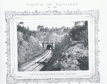 Bendigo Historical Society Inc.
Photograph - VIEWS OF BENDIGO, VIEW OF RAILWAY TUNNEL THROUGH THE BIG HILL, 1875 Copy,1970
Sepia photo on a cram board. Shows a railway tunnel through Big Hill near Mt. Herbert. Inscription: Above, 'Views of Bendigo|No.39.'. Below,'View of the Railway Tunnel through the Big Hill near Mt. Herbert', 'N.J.Caire Photo, Sandhurst'. Bottom, 'Casey & Wenborn's Print Forbes & Holmes, Agents',' The length of the Tunnel is about half-a-mile through the hill'. (two copies) Nicholas CaireN.J.Caireplace, bendigo, tunnel through big hill, see: 'views of bendigo' by n .j .caire. 'mp 157' -
Whitehorse Historical Society Inc.
Document, Full steam for Eastlink
Work continuing on Mullum Mullum Valley tunnels and Ringwood bypass and Maroondah Highway bridge (photos).Work continuing on Mullum Mullum Valley tunnels and Ringwood bypass and Maroondah Highway bridge (photos).Work continuing on Mullum Mullum Valley tunnels and Ringwood bypass and Maroondah Highway bridge (photos).eastlink, ringwood bypass, maroondah highway, mullum mullum valley, deep creek road, mitcham, eastern freeway extension, tunnels -
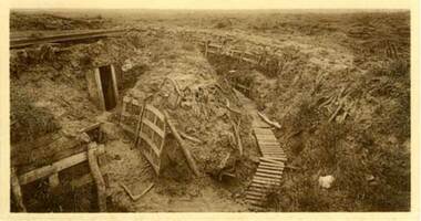 Lara RSL Sub Branch
Photo of the Zonnebeke sector near Ypres in 1919 showing a trench system with dugout/tunnel entrance
Rectangular shaped glass covered picture frame showing a trench system with dugout/tunnel system entrance.ww1, ypres, flanders battlefields, lara r.s.l. belgium. -
 Bendigo Historical Society Inc.
Document - BIG HILL TUNNEL DESCRIPTION
Description of the Big Hill Tunnel, why it was built and David Ogilvie who worked on it with a detailed map of the area.bendigo, planning, big hill tunnel -
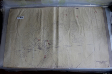 Coal Creek Community Park & Museum
Mine Map, Amended 12/10/1949 Last visible date
8522.1 - Amended copy of object No. 6298, with red texta circles highlighting mine tunnel exits/entrances. -
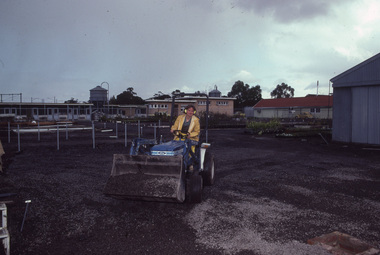 University of Melbourne, Burnley Campus Archives
Photograph - 35mm Colour slides, Construction Work, 1987
Construction work in the Nursery possibly a poly tunnel Aug and Sept 87. 12. "Orchids - Cymbios '74."construction, poly tunnel, nursery, students working outside -
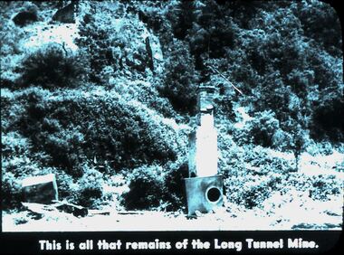 Bendigo Historical Society Inc.
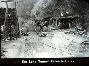
Slide - DIGGERS & MINING. DIGGERS AND MINERS, 1900s
Diggers & Mining. Diggers and Miners. This is all that remains of the Long Tunnel Mine. The photo shows a tunnel on the right of picture and possibly another in the top left corner there are 2 man made structures, the front one appears to be a chimney. Markings: 35 994.5 WAL. Used as a teaching aid.hanimounteducation, tertiary, goldfields -
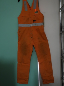 Kiewa Valley Historical Society
Clothes - Workmen - overalls and coat
Work clothes are made of durable fabric and the reflective tape enables it to be safe day and night. McConnell Dowell construcion company: Remote resources and energy projects - building, civil, electrical, fabrication, marine, mechanics, pipelines, rail, tunnel and underground construction. Founded in New Zealand in 1961. In 2003 it became wholly owned subsidiary of Aveng (Sth Africa). It expanded to Australia, Asia and the Middle East in he 1970s. Bogong Power Development consisting of tunnels and shafts and the construction of a new underground Hydro Electric Hydro Electric Power Station. It is the largest Hydro Power project constructed in Australia in 25 years.Bogong Power Development created a new power station extending the Kiewa Hydro Electric Scheme and increasing the generation of renewable energy.1. Overalls: Bright orange cotton gabardine overalls with 6 heavy duty studs down the front and retro reflective tape. Straps over the shoulders. The back has a large pocket sewn dividing it into 2 compartments. The front has 2 side pockets at the hip and 2 pockets at the chest. 2. Coat: Reversible red/grey coat. Sleeveless zip at the front. Pockets on each side of each layer - zip on one side and zipless on the other of each side. Waterproof grey material on one side and red warm materialo on the other. Sewn patches on the outside ".92R Yakka" "McConnell/Dowell/Bogong Power/ Development/ Safety Award/ 1 year/ 250,000" in white and green and on the grey side. "Aurora Australia/ picture/ Tunnel Boring machine"1. Black texta print 'Wiffen' and washing instructions label. workman's clothes, bogong power development, mcconnell dowell, high visibility garment -
 Ringwood and District Historical Society
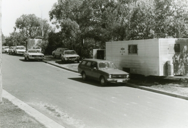
Photographs, 1979-80 MMBW pipe line project at Hubbard Reserve, North Ringwood � cars and caravan of gang
Part of a 43-photo record of the MMBW�s engineering feat in drilling a 12 inch pipe line up to 40 feet deep through rock hardened by volcanic action associated with geological fault that occurs along the line. The work took place from October 1979 to May 1980 on the southern boundary of Hubbard Reserve, North Ringwood. The collection was presented to the Ringwood Historical Research Group by J Clarke on 9th June 1980.E561 N5 Feb 1980 A43 Cars and caravans of the tunnelling gang in Burlock Ave -
 RSL Victoria - Anzac House Reference Library and Memorabilia Collection
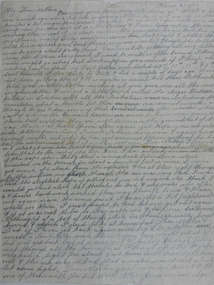
Letter of Edward William Earl, Edward William Earl, 3rd June 1917
Earl's letter to his mother, dated 3rd June 1917, tells of the ordeal of being trapped in a mine for forty three hours at Hill 60 on the Western Front. In his letter, Earl states his belief that it was only because of Sgt Alexander Hood that a rescue attempt was undertaken. Earl died of disease the following month (July 1917). Alexander Hood was killed in action on 31st October 1917. Earl's brother, Stewart Leigh Earl ( 2404 - 46th Battalion), served and survived. Double-sided one page handwritten letter of Edward Earl (3597 - 4 Tunnelling Company, Headquarters 1).ww1, western front, hill 60, edward william earl, 4 tunnelling company, alexander hood -
 Bendigo Historical Society Inc.
Slide - DIGGERS & MINING. DIGGERS AND MINERS, c1930s-1940
Diggers & Mining. Diggers and Miners. . . . The Long Tunnel Extended, . . . Markings: 36 994.5 WAL. Used as a teaching aid.hanimounteducation, tertiary, goldfields -
 Coal Creek Community Park & Museum
Mine Map, 21/01/1945
6298.1 - Map of Coal Creek mine tunnels, coal seams, boreholes, as well as roads and coal leura creeks. -
Victorian Interpretive Projects Inc.
Book, Mining Mud and Medals
Hard covered book on the members of the Australian Tunneling Corp from the Ballarat Electorate during World War One. mining mud and medals, tunellers, australian mining corp, michael taffe, yvon davis, clare gervasoni -
Whitehorse Historical Society Inc.
Article, The Drill to protect valley, 2005
First of four road-headers started drilling at Mitcham Road end of Mullum Mullum Valley tunnel, with photo.First of four road-headers started drilling at Mitcham Road end of Mullum Mullum Valley tunnel, with photo.First of four road-headers started drilling at Mitcham Road end of Mullum Mullum Valley tunnel, with photo.mitcham road, mitcham, eastlink, mullum mullum valley, aubrey, chris, batchelor, peter -
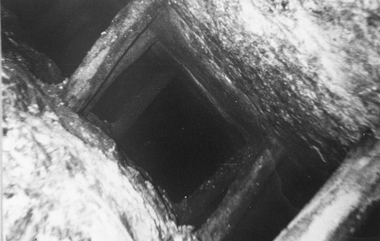 Stawell Historical Society Inc
Photograph, Amalgamated Scotchmans Mine Workings Stawell
Black and white photograph of Amalgamated Scotchman Mine workings Stawell. Western Mining Operations - because the wooden props have been immersed in water for a century they are well preserved. Underground view down mine shaft or tunnel showing timbers holding rock walls. This photograph is in a brown cover.stawell -
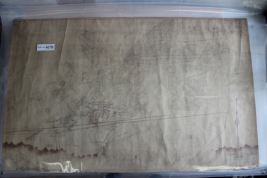
 Bendigo Historical Society Inc.
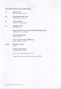
Document - VICTORIA HILL - FURTHER SIGNS, VICTORIA HILL
Handwritten carbon copy, and later typed copy, of a list of further signs for Victoria Hill. Signs include Quartz Veins, Prospecting Shaft, 1929, Concrete Dam, Anticlinal Arch New Chum Line, Engine Beds for Gt Central Victoria (Midway Mine), Prospecting Tunnels, Primitive Tunnel. Notes at the end: Given to Geo & Max Ellis on 31/3/1971 and Prospecting tunnels driven from small Open Cut in 1860's. Notes prepared by Albert Richardson.document, memo, victoria hill, victoria hill, further signs victoria hill, new chum line, gt central victoria (midway mine), victoria quartz, davis, geo ellis, max ellis -
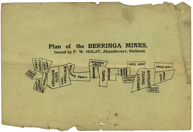 Federation University Historical Collection
Plan, Plan of the Berringa Mines
Small printed plan of the of the Berringa Mines, including Price Application, Collins Lease, Birthday Tunnel Extended, Peel Application, Edgar's Lease, Birthday Tunnel North, Kangaroo, William's Fancy, Birthday, South Birthday, Bunge's Lease, Jones' Lease, Verso is an advertisement of r Ballarat Hardware Co.berringa mines, price application, collins lease, birthday tunnel extended, peel application, edgar's lease, birthday tunnel north, kangaroo, william's fancy, birthday, south birthday, bunge's lease, jones' lease, ballarat hardware co. f.w holst, stockbrokers, cgt -
Whitehorse Historical Society Inc.
Article, Crossing work starts, 2003
Article on grade separation at Middleborough Road railway crossing; with items on maintaining tunnel design in proposed Mitcham Frankston Freeway.Article on grade separation at Middleborough Road railway crossing; with items on maintaining tunnel design in proposed Mitcham Frankston Freeway.Article on grade separation at Middleborough Road railway crossing; with items on maintaining tunnel design in proposed Mitcham Frankston Freeway.eastern freeway extension, railway crossings, middleborough road, blackburn, laburnum railway station -
Clunes Museum
Document, 1875, 1876,1878
.1 Green page headed "Yankee Tunnel" showing dates and depths dug and depths of tunnel costings on reverse of page, calculations in centre .2 Blue page dated 14 January 1876 headed "Tunnel" showing costings, amount sold, on the reverse shows 1875 dividents with amounts. Also a lost of names and amounts (these have been crossed through) .3 Cream coloured card with 1948 calendar printed on it .4 Memo from Clunes Water Supply dated 6 May 1878 detailing cost of laying on water; Memo addressed to Messrs Hudson's & Sons, Paddock. .5 Blue page dated 21.4/1877 headed "Tunnel" showing costings, amount sold.yankee tunnel, gold mine costings -
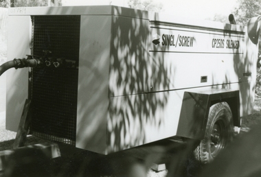 Ringwood and District Historical Society
Photographs, 1979-80 MMBW pipe line project at Hubbard Reserve, North Ringwood � compressor
Part of a 43-photo record of the MMBW�s engineering feat in drilling a 12 inch pipe line up to 40 feet deep through rock hardened by volcanic action associated with geological fault that occurs along the line. The work took place from October 1979 to May 1980 on the southern boundary of Hubbard Reserve, North Ringwood. The collection was presented to the Ringwood Historical Research Group by J Clarke on 9th June 1980.E561 N6 Feb 1980 A43 Compressor of the tunnelling gang on the sewer line in Burlock Ave -
Port Melbourne Historical & Preservation Society
Photograph - Council workers, Kenny Hall and Robin Donchi Snr, Port Melbourne, 1980s
Probably taken in the 1980sKenny Hall and Robin Donchi Senior near Liardet and Pickles Streets digging test holes for a tunnel under Cruickshank Street.engineering - roads streets lanes and footpaths, robin donchi snr, ken hall