Showing 1122 items matching " waterways"
-
 Lakes Entrance Historical Society
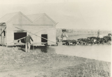
Photograph - Bullock Team c1900, East Gippsland Victoria, 1900 c
Black and white photograph showing a bullock team transporting a building through a waterway under the watchful eye of two men one on horse back while an older man looks on, flat terrain East Gippsland Victoria..Also a second back and white photograph of a bullock team towing a timber building on a trailer along a road cutting in Gippsland transport, buildings -
 Eltham District Historical Society Inc
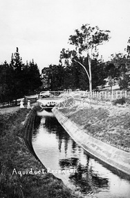
Photograph, Tom Prior, Maroondah Aqueduct, Research, Vic, c.1895
Built for opening in 1891 to take water from Maroondah to Reservoir. Part of a slide show presentation "Bridges & Waterways of the Shire" by Russell Yeoman to the 13 September 1989 Society meeting. The presentation included slides of historic photos from the Shire of Eltham Pioneers collections as well as several recent views.This photo forms part of a collection of photographs gathered by the Shire of Eltham for their centenary project book,"Pioneers and Painters: 100 years of the Shire of Eltham" by Alan Marshall (1971). The collection of over 500 images is held in partnership between Eltham District Historical Society and Yarra Plenty Regional Library (Eltham Library) and is now formally known as the 'The Shire of Eltham Pioneers Photograph Collection.' It is significant in being the first community sourced collection representing the places and people of the Shire's first one hundred years. The Reynolds family were early settlers in Research. The Reynolds/ Prior collection of photographs were taken by Tom Prior, the maternal uncle of Ivy Reynolds, around 1900 and the 60 photos in the album give a fine overview of many of the landmarks of Research and Eltham over 100 years ago. lvy lived in the family home for many years at 106 Thompson Cres Research. Ivy's father, Ernst Richard Reynolds and grandfather, Richard Reynolds, lived at the same address. Ivy's father Richard worked for Mr. Trail on his property in Research. Reynolds Road is named after the family. Mr Tom Prior (wife Eva) worked at the Melbourne zoo. He was very innovative and made his own camera, using the black cloth hood to exclude the light. The photographs are a reminder of the rural nature of Research and Eltham and its rich heritage.Digital image (Neg copy missing)shire of eltham pioneers photograph collection, research (vic.), maroondah aqueduct, aqueduct, reynolds prior collection -
 Lakes Entrance Historical Society
Painting - oil painting, The Entrance Lakes Entrance viewed from Jemmys Point
... Waterways ...oil paintingwaterways -
Lakes Entrance Historical Society
Book, Green Os, The Gippsland Lakes, 1978
... Waterways ...A summary of knowledge of the history and development on the Gippsland Lakes, Victoria, gathered from newspapers, journals and some original research.Ruth Clark. Thankyou for your interest and Assistance Ruth O S Green 1.3. 1978waterways -
 Lakes Entrance Historical Society
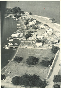
Photograph, Shaving Point Metung Victoria, 1960
... Waterways ...Black and white aerial photograph of village of Metung showing hotel and main wharf and private jetties on Bay side, and beach on Lake King side with road to Shaving Point Metung Victoria. Also a black and white photograph of Village Store Metung Victoria 1930 cwaterways -
 Lakes Entrance Historical Society
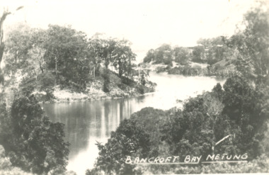
Postcard, Chinamans Creek, Bancroft Bay Metung Victoria, 1930 c
... Waterways ...Black and white postcard of timbered shore of Chinamans Creek looking south towards Bancroft Bay Metung Victoria. Also three small black and white postcards taken from same viewing point Metung. Plus three other colour photos of a more recent view waterways -
 Lakes Entrance Historical Society
Postcard, Tambo River at Tambo Upper Victoria, 1/02/2024 12:00:00 AM
... Waterways ...Black and white photograph of the cliffs on the Tambo River at Tambo Upper Victoria. Also two colour photographs of same cliff taken 1999 visit of Monkhouse family 6th to 24th February 1924 on backwaterways -
 Lakes Entrance Historical Society
Postcard - Reeves Channel, 1910 c
... Waterways ...Black and white postcard showing view of Reeves channel looking west toward Metung west end of Rigby and Fraser Islands mouth of Maringa creek lower right with neat mill workers cottages on flat Lakes Entrance Victoriawaterways -
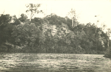
 Lakes Entrance Historical Society
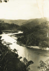
Photograph - Snowy River Gorge at Turlock Ard, Rev John Flynn, 1906
... Waterways ...Photographic proof on light cardBlack and white photograph of views of Snowy River Gorge at Tulock Ard Gelantipy VictoriaJohyn Flynn Postcards from Buchan P39waterways -
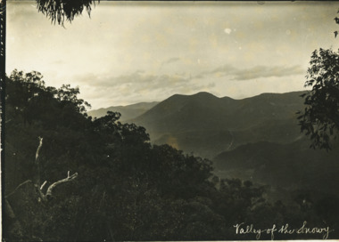 Lakes Entrance Historical Society
Photograph - Valley of the Snowy, Rev John Flynn, 1906
... Waterways ...Photographic proof on light cardBlack and white photograph of Snowy River from top of Turnback Mountain VictoriaValley of the Snowywaterways -
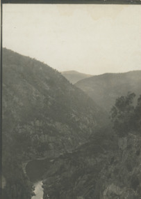
 Lakes Entrance Historical Society
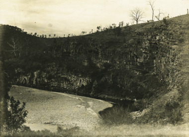
Photograph - Snowy River at Quails Buchan, Rev John Flynn, 1906
... Waterways ...Photographic proof on light cardboardBlack and white photograph of the Snowy River at Quails Buchan VictoriaThe Snowy near Buchanwaterways -
 Lakes Entrance Historical Society
Photograph - Coates Bluff Buchan River, Joyhn Flynn, 1906
... Waterways ...This is a photographic proof on light cardBlack and white photograph of Coates Bluff on Buchan River VictoriaJohn Flynn Postcards from Buchan waterways -
 Lakes Entrance Historical Society
Postcard - Snowy River at Buchan, Rose Series P531, 1970 c
... Waterways ...Black and white postcard of the Icicles a stalectite formation in the Buchan Caves 05305.1 Photo by Bulmer Donor Max Davenport 16 March 2019Black and white postcard of the peaceful Snowy River near Buchan VictoriaA Glimpse of the Snowy River near Buchan Vicwaterways -
 Lakes Entrance Historical Society
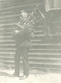
Photograph - Tom McMurtrie, Bullumwaal Victoria
... Waterways ...Black and white photograph of Tom McMurtrie playing his bagpipes Bullumwaal Victoria. Also a black and white photograph of a picnic group at Bullumwaal waterways -
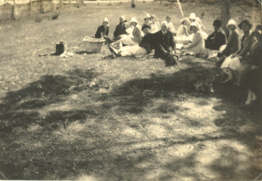 Lakes Entrance Historical Society
Photograph - Picnic party at Buchan Victoria, 1920 c
... Waterways ...Also a black and white photograph of a male visitor beside a kangaroo 04526.1 9 x 6 cmBlack and white photograph of picnic party during visit to Buchan Victoria. Also a black and white photograph of a male visitor beside a kangaroo waterways -
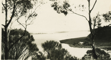
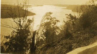 Lakes Entrance Historical Society
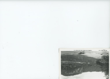
Photograph - Reeves River, 1920 c
... Waterways ...Also another black and white photograph of same view with a man in foreground 05298.1Black and white photograph showing view of Reeves River looking west towards Metung with islands Rigby and Flanagan on left and Nungurner on right Jemmys Point Lakes Entrancewaterways -
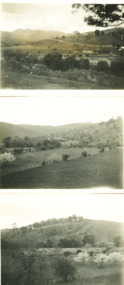 Lakes Entrance Historical Society
Photograph - Buchan Victoria, M O Fish, 1933
... Waterways ...Black and white photographs of Buchan taken from different positions Buchan Victoriawaterways -
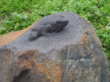 City of Ballarat
Artwork, other - Public Artwork, Joe Pratt et al, Hidden Waterway, 2016
To create 'Hidden waterway' (2016) Artist Forest Keegel held workshops with the people of Ballarat East who drew images in the park of threatened local fauna and waterbugs that once inhabited this land. Those images were then translated into carvings by sculptor Joe Pratt across 20 boulders creating a trail throughout the park. The artwork is of aesthetic and social significance to the people of Ballarat20 bluestone boulders with carvings across the surface creating a trail throughout the park forest keegel, joe pratt, ballarat east, pennyweight park -
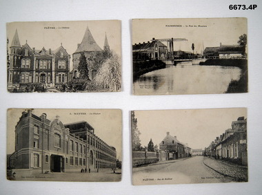 Bendigo Military Museum
Postcard - POSTCARDS, PHOTOGRAPHIC, C.1914 - 18
Photographs of regional towns in Northern France that were sites of important battles in WW1 and WW2. Both towns are locations of Military Cemeteries.1. B & W photo of French Chateau in Fletre, Flanders, France. 2. B & W photo of Hazebrouck- Le Pont De Meuniers. A waterway in Northern France. 3. B & W photo of Hazebrouck - Watten- La Filature Carts Theatre in Northern France. 4. B & W photo of Fletre - Rue De Bailleul - Street of town in Northern France.1. Headed Fletre - La Chateau. 2. Headed Hazebrouck - Le Pont Des Meuniers. 3. Headed 3. Watten - La Filature. At bottom Imp. Gobrecht Hazebrouck. 4. Bottom - Fletre - Rue De Baillel and Imp Gobrecht Hazebrouck.passchendaele barracks trust, postcards, flanders -
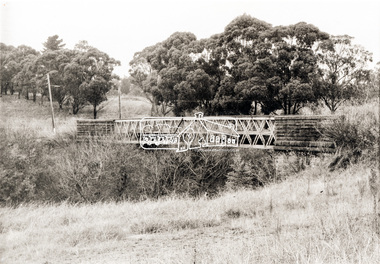 Eltham District Historical Society Inc
Photograph, Old Lower Plenty Bridge, c.1970
Old bridge across the Plenty River at Lower Plenty now part of the Plenty River Trail. Part of a slide show presentation "Bridges & Waterways of the Shire" by Russell Yeoman to the 13 September 1989 Society meeting. The presentation included slides of historic photos from the Shire of Eltham Pioneers collections as well as several recent views.Black and white photographmain road, plenty river, bridge, lower plenty, plenty river trail -
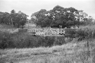 Eltham District Historical Society Inc
Negative - Photograph, Russell Yeoman, Old Lower Plenty Bridge, c.1970
Old bridge across the Plenty River at Lower Plenty now part of the Plenty River Trail. Part of a slide show presentation "Bridges & Waterways of the Shire" by Russell Yeoman to the 13 September 1989 Society meeting. The presentation included slides of historic photos from the Shire of Eltham Pioneers collections as well as several recent views.Roll of 35mm black and white negative film, 4 of 7 stripsIlford HP4bridge, lower plenty, main road, plenty river, plenty river trail -
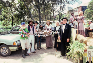 Eltham District Historical Society Inc
Photograph, Grand Parade, Eltham Community Festival, 17 Nov. 1984
The Society again arranged a float for the festival parade. Members dressed appropriately to the theme "Pioneers of Eltham". The parade commenced at 12 noon, participants assembling at 11.30am in Cecil Street. As in past parades, several members of the Victorian Folk Music Club accompanied the Society. The Society also arranged a display at the Eltham Community Centre in association with the activities there over the Festival weekend. The theme of this year's display was the waterways of the local area.35mm colour positive transparency Mount - Kodak Kodachrome Cardeltham, eltham festival, parade, parade floats, central park, doug orford, eltham shire office, garnet burges, joh ebeli, opal smith, panther place, peter bassett smith, peter bassett-smith, russell yeoman, victorian folk music society -
 Melbourne Tram Museum
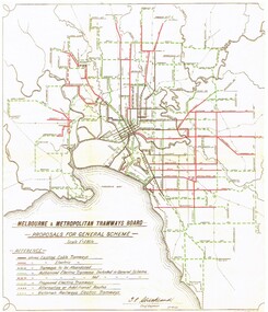
Document - Photocopy, "MMTB Proposals for General Scheme, c1970
Colour photocopy of a MMTB drawing titled "MMTB Proposals for General Scheme showing a detail plan of tramways proposed for Melbourne 1923. Signed by J. Strickland 27-8-1923. Shows cable trams, existing tramways, authorised tramways, proposed, VR tramways, rail lines and waterways. Not known when colour copy actually made - could have been an AETA or a TMSV reproduction. See Reg Item 2089 for an original of this document.trams, tramways, mmtb, melbourne, cable trams, electric trains, tramways, proposals, planning -
Lakes Entrance Historical Society
Photograph, 1992
... Waterways ...Date made December 1992Colour photograph close up view of the suction pump from the dredge Paynesville sitting on Eastern Wharf, clearly shows the name of maker Ruston Lincoln England. Lakes Entrance Victoriadredging, waterways -
 Lakes Entrance Historical Society
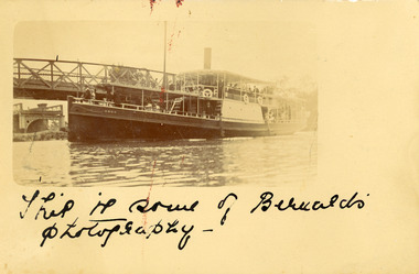
Postcard, Carpenter
... Waterways ...Omeo passing Sale bridge, Sale Victoria.This is some of Bernard's photography, One penny stamp on reverse.bridges, waterways -
 Lakes Entrance Historical Society
Photograph, 1980
... Waterways ...Colour photograph of the deck of the fishing boat Minawie almost covered with a successful shot of school whiting, estimated as 70 bins. Taken at sea. Lakes Entrance Victoriafishing industry, waterways -
 Lakes Entrance Historical Society
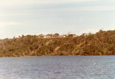
Photograph - Kalimna, Fraser Nancy, 1980c
... Waterways ...Colour photograph of private residences on the Kalimna escarpment. It shows houses above a timbered cliff at the northern shore of the North Arm of the lake, bare areas on cliff side indicating recent land slide. Lakes Entrance VictoriaHouses Seaview Parade Kalimna North Arm Lakes Entrance (on back) topography, waterways -
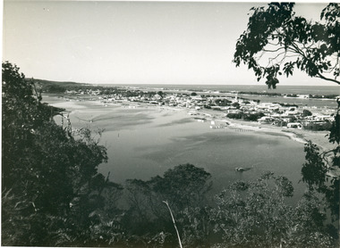 Lakes Entrance Historical Society
Photograph - Township, 1955
... Waterways ...Also black and white postcard, similar view, titled Lakes Entrance through the trees from Lovers Walk. Bulmer copyright.Black and white photograph of a view from Kalimna Heights overlooking township. Shows North Arm, Marine Parade, Cunninghame Arm and sand hummocks with Bass Strait in distance. Lakes Entrance Victoriatownship, waterways -
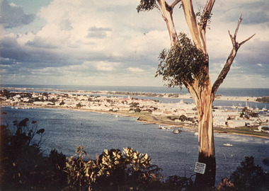 Lakes Entrance Historical Society
Photograph - Township, 1980
... Waterways ...Also two different views of Lakes Entrance from KalimnaColour photograph showing the township situated on the land between the two stretches of water, the North Arm and the Cunninghame Arm. In the background can be seen the sand hummocks and the Southern Ocean. Lakes Entrance Victoria township, waterways -
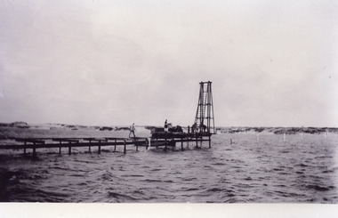 Lakes Entrance Historical Society
Photograph - Footbridge, Jemmeson Edie, 1936
... Waterways ...One other copyBlack and white photograph of the first section of the footbridge being constructed across the Cunninghame Arm, it shows work underway. Pile driver at end of partly constructed bridge. Lakes Entrance Victoriabridges, waterways