Showing 1815 items
matching a view street viewing
-
 Ringwood and District Historical Society
Flyer, Land Sale Advertisement and auction notice - Range View Estate, Ringwood, Victoria - 1920
Advertisement for sale of 150 residential allotments with terms of sale, summary of local features and services, and map showing location and layout of subdivision within the boundary of Mitcham to the west of Ringwood, Victoria. Copy of newspaper advertisement (The Herald, Melbourne, Wednesday 3 March, 1920) refers to public auction date for Range View Estate Ringwood - Saturday, 27th March, 1920.Subdivision includes Deep Creek Road, Range View Grove, Warnes Road, Tarrangower Avenue, Prince Edward Avenue, James Avenue, and White Horse Road, Mitcham. Agents - Phillips & Nicholson, 281 Collins Street, Melbourne, Telephone Central 10907. -
 The Beechworth Burke Museum
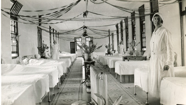
Photograph, 1934
The photo is taken in 1934 and illustrates the internal view of a ward in the Mental Hospital at Beechworth. Some patients in beds and three nurses are in view. Beds were arranged in lines alongside the walls and there were no partitions or screens to create privacy for patients. Furniture was simple and humble; bed frames were made of metal or wood and pillowcases and covers for the attendant`s tables were sometimes made of blue-striped canvas or calico. Large windows in the walls were offering ample light and the room was well-tended, with Christmas decoration, flowers, pots and carpets on the floor. The nurse in the foreground is Miss Neary. The Mayday Hills Hospital was constructed between 1864 and 1867, with buildings created in a number of periods. It formally opened on 24 October 1867 and, along with the Ovens Hospital and the Benevolent Asylum, made Beechworth a prominent social welfare centre in Victoria. The need for an institution of this kind was arisen due to the increased number of people with mental disturbances (induced by the harsh living conditions on the goldfields) and the remoteness of the district from Melbourne. The site was chosen for its panoramic view of the countryside, the hilltop atmosphere and the native fauna, all contributing to the cure of patients. The Hospital was originally named the “Ovens Lunatic Asylum” but, during the centenary celebrations in 1967, the name was officially changed to “Mayday Hills Hospital”, showing the gradual shift in the perception and understanding of mental health conditions over the last decades. The Hospital lies on the traditional land of the Kulin Nation. This photograph is historically significant as it provides an insight into the living conditions of patients admitted to the Mayday Hills Hospital at the beginning of the 20th century. It also contributes to the understanding of the district`s development and its importance to the course of Victoria`s history. Additionally, it provides important information about the way mental health conditions were perceived at that time and how patients were treated. Black and white rectangular photograph printed on paper. Reverse: 1997.2665/ To Miss JA.Peach/ [hallmark: Printed by Harringtons]/ With best wishes/from/H.Jeanes/for 1934.mayday hills hospital, benevolent asylum, ovens hospital, ovens lunatic asylum, kulin nation, beechworth, patients, nurse, social welfare, goldfields, melbourne, mental health, living conditions, blue-striped canvas, calico, bed frames, miss neary, mental disturbances, traditional land, centenary celebrations -
 Greensborough Historical Society
Photograph - Digital image, View of Bicton Street from Gladstone Road, 1950_
... View of Bicton Street from Gladstone Road...This view of Bicton Street Greensborough, taken from... photo. This view of Bicton Street Greensborough, taken from ...This view of Bicton Street Greensborough, taken from Gladstone Road Briar Hill circa 1950 shows the rural nature of the suburb at this time.Digital copy of black and white photo.bicton street greensborough, gladstone road briar hill -
 Greensborough Historical Society
Photograph - Digital Image, View of Greensborough near Blackjack, 1954_
View of Greensborough near Blackjack. The Blackjack property, house and acres of fruit orchards ran down to the Plenty River off Hume Street Greensborough and was the home of the Robinson family to late 1956. The photographs were taken as slides by Frank Robinson and digitised by his son James in 2015.Digital copy of colour photograph.robinson family, blackjack -
 Greensborough Historical Society
Photograph - Digital Image, View of Blackjack near Greensborough, 1954_
View of Blackjack near Greensborough. The Blackjack property, house and acres of fruit orchards ran down to the Plenty River off Hume Street Greensborough and was the home of the Robinson family to late 1956. The photographs were taken as slides by Frank Robinson and digitised by his son James in 2015.Digital copy of colour photograph.robinson family, blackjack -
 Victoria Police Museum
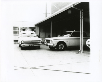
Photograph (police car)
Photo of the rear yard of the Mobile Traffic Section offices at 145 Chapel St. St.KildaHolden ute, front view, registration number JHE-915, parked at a right angle to a Studebaker Lark, side view. Circa 1964police vehicles; wireless patrol; motor transport branch; motor transport section; holden ute; studebaker lake car -
 Victoria Police Museum
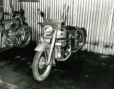
Photograph (police motorcycle)
Front view of Ariel, registration number BJ-340, with damage to windshield, parked against a corrugated tin wall. There is a side view of a second Ariel to the left of the photograph with no identifying markings.police vehicles; wireless patrol; motor transport branch; motor transport section; police motorcycles; ariel motorcycle -
 Warrnambool and District Historical Society Inc.
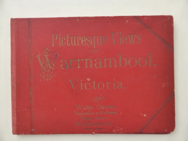
Book, Picturesque Views of Warrnambool, 1894
This album has been produced in Germany at the end of the 19th century for the Warrnambool tourist market. It was sold in the book shop of Walter Davies. The father of Walter Davies, also called Walter, was a law clerk and accountant who established the book and stationery shop in Timor Street in the late 1860s. The business was operated by Walter Davies Senior, then his son and later the grandsonThis album is of interest for several reasons:- 1. It is an interesting example of the type of tourist souvenir available to visitors to Warrnambool in the late 19th century. 2. It contains 13 photographs of Warrnambool in the late 19th century and these are of considerable historical value. 3. It is a good example of the type of articles sold by Walter Davies at his Timor Street shop in 1894. This is a hard cover folder containing 13 black and white photographs of Warrnambool and surrounds. The photographs are on several sheets of white paper joined together in concertina fashion to fit into the folder but they have become detached from the folder. Some of the photographs are torn at the edges. The cover of the folder has embossed gold lettering and the narrow spine is faded and the front cover is a little torn and stained. The inscription. ‘Xmas 1894’ is handwritten in black ink. ‘Picturesque Views of Warrnambool Victoria’ ‘Walter Davies, Bookseller & Stationer, Timor Street, Warrnambool’ ‘Printed in Germany’ ‘Xmas 1894’ water davies and son, warrnambool -
 Victoria Police Museum
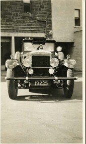
Photograph (police car), Kodak
Front view of Daimler #1 in 1927. The first Daimler patrol car purchased by Victoria Police. Known as the 35HP model.Front view of Daimler, registration number 19235, in Russell Street yard circa 1926-1936police vehicles; transport; motor police branch; daimler car; wireless patrol; yellow peril; russell street -
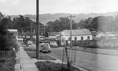 Eltham District Historical Society Inc
Photograph, Looking down Pryor Street to Main Road, Eltham, c.1960
Eltham Plumbing Supplies (Lennie Whiteway Plumbing) located on the right side of the street. It later became the Eltham Bookshop and sold cane ware as well. On the corner with Main Road is the local branch of the State Bank of Victoria. The building still stands and is the present day Westpac bank branch. The Railway Station Master's house on opposite side was later demolished to make way for a carpark. 27 Aug 1963: Pettion for Bankruptcy re Jeanette Patricia Whiteway of 88 Napoleon Street, Eltham, house duties, and lately carrying on a business at Pryor Street, Eltham in partnership with another as a plumber under the names Eltham Plumbing Supplies and L. & J.P. Whiteway 1963 'SEQUESTRATION ORDERS AND FIRST MEETINGS', Commonwealth of Australia Gazette (National : 1901 - 1973), 12 September, p. 3259. , viewed 10 Jul 2018, http://nla.gov.au/nla.news-article241015035 Orders for discharge of bankruptcy suspended till 23 March 1967 for Leonard Whiteway and Jeanette Patricia Whiteway of 5 John Street, Eltham 1967 'NOTICE OF ORDERS OF DISCHARGE', Commonwealth of Australia Gazette (National : 1901 - 1973), 11 May, p. 2427. , viewed 10 Jul 2018, http://nla.gov.au/nla.news-article241040009Black and white photograph prints (x3) Negative (copy) 4x5 large format Black and White (x2)Shire of Elthampryor street, eltham plumbing supplies, main road, eltham, eltham bookshop, jeanette patricia whiteway, lennie whiteway plumbing, leonard whiteway, state bank of victoria, station masters house, westpac bank -
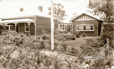 Eltham District Historical Society Inc
Photograph, Peter Bassett-Smith, 22 York Street, Eltham (renumbered 28), c.1933, 1933c
22 York Street, Eltham (re-numbered 28). One view north east from Bible Steet c.1933, the view of the house from the north c.1933. Original house of 4 rooms, weatherboard Baltic, line Baltic Pine, tongue and grooved boards and/or wall papered hessian. Skillion added c.1930, pitch roof room added c.1932. W.B. Bassett-Smith FRIBA Architect, W. Enright Builder. House in Bridge Street.Two sepia photographs of 22 York Street, Eltham, renumbered 28, former home of Bassett-Smith family.houses, york street, peter bassett smith -
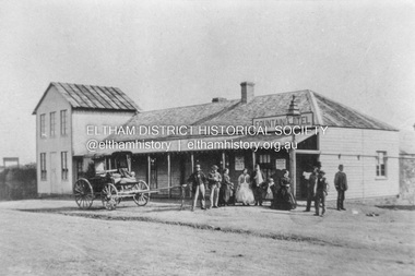 Eltham District Historical Society Inc
Photograph, Fountain Hotel, Main Road, Eltham
Digitised from scanned print of original postcard of Fountain Hotel, Main Road Eltham (later Evelyn Hotel) early view showing two storey section. Built in 1852 as the Fountain of Friendship Hotel, later named the Fountain Hotel in the 1880s. Located on the southwest corner of Maria (Main) and Pitt streets. Later known as the Evelyn or Evelyn Arms Hotel, it was de-licensed in 1919. The hotel was totally destroyed by fire on Wednesday, February 18, 1931Digital file scan of photo print copy and photocopy of original image of Fountain Hotel, Main Road Eltham (later Evelyn Hotel) early view showing two storey sectionhotels, eltham, fountain hotel, evelyn hotel, main road, pitt street -
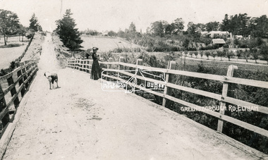 Eltham District Historical Society Inc
Photograph, Bridge over the Diamond Creek, Greensborough Road, Eltham, c.1885
... (1874) bridge in Bridge Street, Eltham looking east over ...Original (1874) bridge in Bridge Street, Eltham looking east over the Diamond Creek towards Maria Street (Main Road) at Little Eltham. In the distance to the right on Maria Street is the Methodist Church (1881), now Uniting Church, and the adjacent Commercial Bank of Australia branch building (1878). Part of a slide show presentation "Bridges & Waterways of the Shire" by Russell Yeoman to the 13 September 1989 Society meeting. The presentation included slides of historic photos from the Shire of Eltham Pioneers collections as well as several recent views.Photo of original 1875 timber and gravel surface bridge over the Diamon Creek in Bridge Street with views of orchards representative of the farming lands as well as the development along the northern end of Maria Street.Black and white photograph copybridge street, bridge street bridge, cba bank, diamond creek (creek), eltham, little eltham, main road, maria street, methodist church, uniting church -
 Eltham District Historical Society Inc
Photograph, View from Porter Street, Eltham to south east, c.1994, 1994c
... View from Porter Street, Eltham to south east, c.1994...Colour photograph of view southeast from Porter Street... melbourne Photograph View from Porter Street, Eltham to south east ...Colour photograph of view southeast from Porter Street, Eltham c.1994 showing new housing development on Riverview Estate formerly Fabbro farm.porter street, eltham, riverview estate, m fabbro -
 Eltham District Historical Society Inc
Photograph, Spring Excursion, Hume and Hovell bus tour Stage 2, Seymour, Benalla; 26 Oct 1997, 26/10/1997
MONUMENT HUNTING THE HUME AND HOVELL WAY (Newsletter No. 117, November 1997, by Diana Bassett-Smith) Sunday October 26 1997 dawned bright and very warm. Some twenty-five members, complete with picnic baskets, met outside the Eltham Library awaiting the Cobb and Co. large coach which would be taking us on the second leg of our travels along the route of the early explorers Hume and Hovell. Stephen West was our very good driver for the day. He would be guided around the circuitous route by Russell Yeoman wh9 had made a detailed study, not only of the intended route, but of the story of these two explorers. During the trip Russell regaled us with poetry, quotations from the Journals and the History of the Shire of Seymour, "The New Crossing Place: by Martindale, 1982, (now Mitchell Shire due to the recent amalgamations). We headed towards the Hume Highway via Greensborough and Cooper Street and proceeded north to our first stop, noting on the way Monument Hill in the distance which is near Kilmore and, according to Russell, well worth the effort to visit as the view across the valley is magnificent. Past Sunday Creek Valley, Mt Piper and Mt Disappointment, all traversed and noted and named by them. We passed through Tallarook, then onto Seymour where we took photos of the monument telling us that Hume and Hovell had passed through on the 28th of October 1824. We also deviated down Hume and Hovell Road viewing deer and emu farming and the Bellbourie property now a sanctuary. Leaving Seymour behind we travelled up the Avenel Road to the Avenel monument, pyramidal in design of four reducing square blocks with a sharply pointed peak, erected in 1924 in memory of the 1824 exploration. The day was warming up and the countryside showing the dryness of the current drought. A parallel note had been made in their journal too of 1824 of the drought appearance of the country they were traversing. At Seven Creeks, Euroa we stopped for some minutes to check the monument placed 20th November 1924 to commemorate their passage on the 29th December 1824. More photos. Russell had pointed out the abrupt termination of the distant ranges which is noted in their journal. The next monument is beside the road at the entrance to Honey Suckle Creek Caravan Park, Violet Town. The squarish shaped monument some eight feet high is topped with a simple steel cross, and was to mark the date of 28th December 1824 and built for the 20th November 1924. By now it was 12.20 and nearly lunchtime as we drove along the Warranbayne Road to Roach's Road, monument hunting without success. Though there is a large, what appears to be an old timber sign which was hard to read, maybe this was the lost monument. In many of the paddocks hay had been cut and baled or was being cut, what a contrast to the rugged country they had passed through which was smoky from the fires of the natives burning off By 1.00 pm we were at Benalla and pulled up beside the park where abundant beds of roses filled the air with their scent and the smell of barbecued food twitched the nostrils whilst the cheerful sounds of other picnickers could be heard throughout the park. We left the bus and collected up our picnics, dispersed to the various tables and enjoyed the shade from the various European trees. 2.00 pm and we were on the road again driving along the Benalla, Mansfield, Yea road. The Swanpool monument states that they passed four miles south and returned three miles north. Then we stopped at the Barjarg monument which notes that they camped near this spot. It is again a pyramidal monument and this time topped with a steel arrow indicating their route of the 29th November 1824. Half an hour later we came to another monument, again with a steel arrow marker on top and the plaque dated the 2nd of 12th 1824. Erected on the 12th of 12th 1924. "They blazed the way that we might inherit the land." Another square based and needle topped monument appeared at Yarck near Yea and this plaque records the date of 3 December 1824. Near McGuigans Road Russell related that the expedition had lost a dog but it had found them next day, the dog was apparently torn by a kangaroo. A short while later Russell reminded us here of the problems they encountered in crossing the Goulburn River near Molesworth where banks were high, water deep and wide. "Good coat of grass but quite dry due to drought". At Yea we stopped for afternoon tea and raided the last of our picnics and looked at the monument to their journey of 1824, situated at a corner of the gardens near the bowling green. No photo – we were out of film. We returned home via Kinglake West and Whittlesea past the Yan Yean Reservoir, not full. 5.00 pm back at Eltham we emptied out of the bus and everyone, including Joan Cole, collected their things, Joan also had the major souvenir of the day, a large carp she had picked up from the river bank, her cat was in for a great feast. The day was made so interesting by the informed commentary which Russell provided. His background knowledge of the route and nature of the journey could only have come from many hours of reading and driving the area. Thank you to Russell and to everyone who made the day so informative and pleasurable. Diana Bassett-Smith. Record of the Society's history of activities - Spring 1997 excursionRoll of 35mm colour negative film, 6 stripsFuji 200shire of eltham historical society, activities, pretty hill, seymour, benalla, hume and hovell, monuments -
 Eltham District Historical Society Inc
Photograph, Spring Excursion, Hume and Hovell bus tour Stage 2, Seymour, Benalla; 26 Oct 1997, 26/10/1997
MONUMENT HUNTING THE HUME AND HOVELL WAY (Newsletter No. 117, November 1997, by Diana Bassett-Smith) Sunday October 26 1997 dawned bright and very warm. Some twenty-five members, complete with picnic baskets, met outside the Eltham Library awaiting the Cobb and Co. large coach which would be taking us on the second leg of our travels along the route of the early explorers Hume and Hovell. Stephen West was our very good driver for the day. He would be guided around the circuitous route by Russell Yeoman wh9 had made a detailed study, not only of the intended route, but of the story of these two explorers. During the trip Russell regaled us with poetry, quotations from the Journals and the History of the Shire of Seymour, "The New Crossing Place: by Martindale, 1982, (now Mitchell Shire due to the recent amalgamations). We headed towards the Hume Highway via Greensborough and Cooper Street and proceeded north to our first stop, noting on the way Monument Hill in the distance which is near Kilmore and, according to Russell, well worth the effort to visit as the view across the valley is magnificent. Past Sunday Creek Valley, Mt Piper and Mt Disappointment, all traversed and noted and named by them. We passed through Tallarook, then onto Seymour where we took photos of the monument telling us that Hume and Hovell had passed through on the 28th of October 1824. We also deviated down Hume and Hovell Road viewing deer and emu farming and the Bellbourie property now a sanctuary. Leaving Seymour behind we travelled up the Avenel Road to the Avenel monument, pyramidal in design of four reducing square blocks with a sharply pointed peak, erected in 1924 in memory of the 1824 exploration. The day was warming up and the countryside showing the dryness of the current drought. A parallel note had been made in their journal too of 1824 of the drought appearance of the country they were traversing. At Seven Creeks, Euroa we stopped for some minutes to check the monument placed 20th November 1924 to commemorate their passage on the 29th December 1824. More photos. Russell had pointed out the abrupt termination of the distant ranges which is noted in their journal. The next monument is beside the road at the entrance to Honey Suckle Creek Caravan Park, Violet Town. The squarish shaped monument some eight feet high is topped with a simple steel cross, and was to mark the date of 28th December 1824 and built for the 20th November 1924. By now it was 12.20 and nearly lunchtime as we drove along the Warranbayne Road to Roach's Road, monument hunting without success. Though there is a large, what appears to be an old timber sign which was hard to read, maybe this was the lost monument. In many of the paddocks hay had been cut and baled or was being cut, what a contrast to the rugged country they had passed through which was smoky from the fires of the natives burning off By 1.00 pm we were at Benalla and pulled up beside the park where abundant beds of roses filled the air with their scent and the smell of barbecued food twitched the nostrils whilst the cheerful sounds of other picnickers could be heard throughout the park. We left the bus and collected up our picnics, dispersed to the various tables and enjoyed the shade from the various European trees. 2.00 pm and we were on the road again driving along the Benalla, Mansfield, Yea road. The Swanpool monument states that they passed four miles south and returned three miles north. Then we stopped at the Barjarg monument which notes that they camped near this spot. It is again a pyramidal monument and this time topped with a steel arrow indicating their route of the 29th November 1824. Half an hour later we came to another monument, again with a steel arrow marker on top and the plaque dated the 2nd of 12th 1824. Erected on the 12th of 12th 1924. "They blazed the way that we might inherit the land." Another square based and needle topped monument appeared at Yarck near Yea and this plaque records the date of 3 December 1824. Near McGuigans Road Russell related that the expedition had lost a dog but it had found them next day, the dog was apparently torn by a kangaroo. A short while later Russell reminded us here of the problems they encountered in crossing the Goulburn River near Molesworth where banks were high, water deep and wide. "Good coat of grass but quite dry due to drought". At Yea we stopped for afternoon tea and raided the last of our picnics and looked at the monument to their journey of 1824, situated at a corner of the gardens near the bowling green. No photo – we were out of film. We returned home via Kinglake West and Whittlesea past the Yan Yean Reservoir, not full. 5.00 pm back at Eltham we emptied out of the bus and everyone, including Joan Cole, collected their things, Joan also had the major souvenir of the day, a large carp she had picked up from the river bank, her cat was in for a great feast. The day was made so interesting by the informed commentary which Russell provided. His background knowledge of the route and nature of the journey could only have come from many hours of reading and driving the area. Thank you to Russell and to everyone who made the day so informative and pleasurable. Diana Bassett-Smith. Record of the Society's history of activities - Spring 1997 excursionRoll of 35mm colour negative film, 2 stripsKodak Gold 400-5shire of eltham historical society, activities, pretty hill, seymour, benalla, hume and hovell, monuments -
 Eltham District Historical Society Inc
Photograph, View north east from Porter Street, Eltham, 1994, 1994_
... View north east from Porter Street, Eltham, 1994...Colour photograph of view north east from Porter Street... melbourne Photograph View north east from Porter Street, Eltham ...Colour photograph of view north east from Porter Street, Eltham near Ely Street, 1994porter street, eltham -
 Warrnambool and District Historical Society Inc.
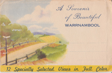
Souvenir - Post Card 12 views of Warrnambool, Nucolorvue Productions, 1950's
This type of folded postcards was popular with tourists in the 1940s, 50s, and 60s and often kept by them for many years afterwards. The views of Warrnambool here, taken about the 1950s, were typical of the Warrnambool postcards available at the time and were mass-produced as many examples survive today. They include photographs of Hopkins Falls, the beach and harbour, Liebig Street, Hopkins River, coastal scenery and the Botanical Gardens. These postcards are of some historical interest, though the photographs appear frequently in many publications. They also have a social significance showing what tourists bought 60 or more years ago.This is a packet in envelope form containing 12 coloured postcards of views of Warrnambool about the 1950s. The photographs are printed on buff-coloured paper and fold up to envelope size so that they can be sent by post. The front cover includes three dotted lines for the address and the back cover has a space to include the name of the sender. One page gives some general information on Warrnambool. Front cover: ‘A Souvenir of Beautiful Warrnambool’, ’12 Specially Selected Views in Full Color’ Back cover: ‘From…’ , ‘Published by Nucolorvue Productions, Elwood, Victoria’ tourism, warrnambool -
 Warrnambool and District Historical Society Inc.
Album, Warrnambool and District 1886 Western Hotel, 1886
... including Thunder Point, views of local streets such as Liebig... Point, views of local streets such as Liebig and Fairy streets ...This album contains a number of local coastal and seascapes including Thunder Point, views of local streets such as Liebig and Fairy streets, panorama views of the town from Manse Hill and Booval Hill and the Botanic Gardens. Buildings included are Cramond and Dickson, St Joseph’s Church, the saleyards. The book itself would have been used by patrons of the Western Hotel when J Fox was licensee, from 1880 until 1887. The hotel had been operating since 1870 when William O’Brien applied for a publican’s license for the house on the corner of Timor and Kepler Streets with five sitting rooms and eight bedrooms. The stone building was designed by Andrew Kerr and built by Williams & Co. The Western Hotel was also the booking office for Cobb and Co Coaches which operated until the railway came to town in 1890. This album has historical significance on different levels. Firstly the photographs provide a view of Warrnambool in the late 19th century. The photos are aesthetically and artistically significant. Many of the buildings in the streetscapes are still recognizable. Secondly the Western Hotel has occupied a prominent site within the CBD for nearly 150 years. It has links to Cobb & Co, an important part of early Australian transport. Large hard covered album. Dark green cover with title in red rectangle on front cover. Text in gold lettering. A variety of photographs mounted on card.Chuck Photo Ballarat on front cover. Small cutting pasted inside front cover, reads as follows,” Will and Estates. Joseph Fox, late of Grosvenor Street, Balaclava who died on 29th July by his will of 11th August 1915 left 3737pounds real estate and 2342 pounds personality to relatives. warrnambool, warrnambool history, warrnambool photographs of the past, western hotel photographs -
 RMIT GSBL Justice Smith Collection
Report, Statement of preliminary views, [1987]
Constitutional Commission Australian Judicial System Advisory Committee Statement of Preliminary ViewsISBN: 0642121559 courts -- australia, court administration -- australia, australia -- constitutional law -- amendments -
 Anglesea and District Historical Society
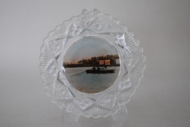
View Ware Dish, Estimated 1920's
... Anglesea and District Historical Society 5B McMillan Street ...Decorative glass surround. Plain centre with scenic view of Anglesea River, bridge and rowers. Crack across centre.anglesea, rowers, view ware -
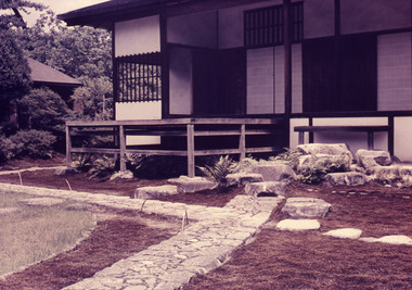 Robin Boyd Foundation
Slide, Robin Boyd, 1964
Robin Boyd wrote two books on Japanese architects and architecture - “Kenzo Tange” published by George Braziller in 1962 and “New Directions in Japanese Architecture” published by Studio Vista in 1968. During the 1960s he travelled several times to Japan to research these books and as part of his role as Exhibits Architect for the Australian Pavilion at Expo ‘70 in Osaka.Colour slide in a mount. Ko-shoin: Moon-Viewing Platform, Katsura Imperial Villa, Kyoto, JapanTokyo, Japan / Japanese Gardens (2) / Katsura Inperial Villa / Step at Ko Shoin and Moon-view pavilion / 8 / Encircled 3 (Handwritten) / Encircled 3 (Handwritten)slide, robin boyd -
Winchelsea and District Historical Society
Collection photos, J W (Jack) McClelland, Circ.1915
A series of photos taken in the Otways circ. 1915 showing aspects of the logging operations The actual logging operations are show including logging , transport and mill operations. Also shown are views of the forest at that time including scenic attractions. The life style of the workers is covered showing both the working and living environments. The photos were taken by J W (Jack) McCleland on glass and copies were made available to the Winchelsea Historical Society by a descendant. The collection shows the working and living environment of workers in the timber industry in the early 1900'sSeries of 70 photos from glass plates showing logging by Hendy & Sons near Mt Sabine and views of the Otways. Taken around 1915Nilotways, timber, henry, sabine mcclelland, rail, photo, -
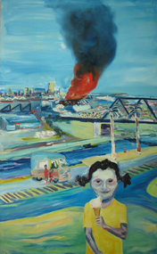 Brimbank City Council Art Collection
Painting, United Transport Fire, 1989
... View of United Transport Fire from Moreland Street Studio... Street Studio. More people viewed the fire than showed up ...Social realism pertaining to the Western SuburbsView of United Transport Fire from Moreland Street Studio. More people viewed the fire than showed up for the Footscray parade a fews earlier. The Mr Whippy van made an economical killing, while the atmosphere was suffering the same results. AR0099social realism, western suburbs -
University of Melbourne, Burnley Campus Archives
Photograph - Black and white print, Aerial View of Burnley Campus, 1977
... river glenferrie road east swan street aerial view ...Framed enlargements. (A) Burnley College and surrounding suburbs showing the nearly constructed Freeway, the College in the bend of the Yarra River, Glenferrie Road to the East Swan Street to the North. (B) Enlargement of (A) showing detail of Burnley College.burnley college, suburbs, freeway, yarra river, glenferrie road, east swan street, aerial view -
 Surrey Hills Historical Society Collection
Photograph, 10 Pembroke Street, Surrey Hills
‘Eignbrook’ at 10 Pembroke Street was built 1904. Until the 1950s this area was the highest spot in the metropolitan area and ships in the Bay could be seen from ground level and views extended almost 360 degrees. A number of homes of this Edwardian period had viewing towers, the one in the photo being that of ‘Maroondah’ at 12 Pembroke Street. Photo taken by W V Hill. Courtesy: Mr William (Bill) Dempsey. Original sepia photograph of a weatherboard home in the Queen Anne style. It has a steep pitched iron roof. It has a woven wire fence across the front of the property and decorative gates. Mounted on white cardboard photo taped on 2 corners.Back of photo is inscribed “Hills, 10 Pembroke St, Surrey Hills”. Card has written underneath the photo, “10 Pembroke St, Home of Hills family, built 1904”pembroke street, house names, surrey hills, hills family, 'maroondah', 'eignbrook', (mr) w v hill, (mr) william (bill) dempsey, journalist, queen anne style, (mrs) annie hill -
 Surrey Hills Historical Society Collection
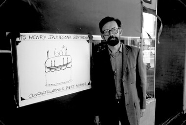
Photograph, Exterior of Henry Jamieson Radio Business, 145 Union Road, Surrey Hills
... view street...Henry was born in View Street and then Newton Street. He... decorated for Henry Jamieson's 60th birthday. Henry was born in View ...Henry was born in View Street and then Newton Street. He went to Box Hill Grammar School. Before his marriage he lived in Mont Albert Road. Adrian Knowles had started a radio shop at 145 Union Road in the 1940s and Henry joined him later continuing the business in his own name. Henry always had an interest in music and became involved in getting the radio station 3MBS established in Kew. For some years Henry and a co-producer presented a prime time Saturday evening programme and also an early morning one.A black and white photograph of a man with dark hair, wearing dark rimmed glasses and a suit coat, is standing beside a white board someone has decorated for Henry Jamieson's 60th birthday.(mr) henry jamieson, view street, newton street, box hill grammar school, mont albert road, union road, surrey hills, 3mbs, adrian knowles -
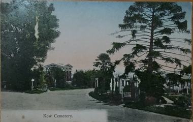 Kew Historical Society Inc
Postcard, Unknown, Kew Cemetery, 1905
This view of the Boroondara General (Kew) Cemetery is dated to 1905 by the inscription and postmark on the reverse. It provides an important visual record of this part of the Cemetery. The postcard can be used to identify the original configuration of the roads and vegetation, some of which was subsequently removed (eg the bunya pine at right). On the Victorian Heritage Database, the construction period given for the Springthorpe Memorial is given as 1897-1907, yet this view of the Memorial in 1905 would suggest that it was virtually completed at an earlier date. (It should be noted that additions such as the wheel of life sculpture were not completed until 1910).This dated photograph is historically important as its inscription confirms it to be one of the earliest postcard representations of the Boroondara General (Kew) Cemetery. It also provides visual evidence of the size and extent of the landscaping by 1905, particularly the layout of the roads (now altered), plantings of the period, and the extent of the land occupied by the Springthorpe Memorial and its gardens, which was subsequently reduced by the trustees of the cemetery in the 1930s. Panoramic view of the entrance driveway in Boroondara General (Kew) Cemetery. At left can be seen the Springthorpe Memorial, and further down on the left the entrance gate, or one of the gates, to the Memorial. Inscribed on reverse: "Miss Brown / Shuan [sic] / Grosvenor Street / M. Brighton. Love from Mother Oct 28th 1905" Postmark: "Melbourne 8 / 2 PM, 28/10/05".springthorpe memorial, boroondara general (kew) cemetery, postcards -- cemeteries -
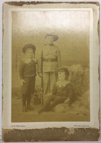 Kew Historical Society Inc
Photograph, G L Massingham, Three Boys, 1901-1910
... australian photographers - g. l. massingham - view street.... Massingham ( (George Leake, active 1866-1921) of View Street, Bendigo...G. L. MASSINGHAM / VIEW STREET. BENDIGO...-1921) of View Street, Bendigo (and Geelong); active in View ...One of a group of unprovenanced photographs donated to the Society by Betty Morgan.While its provenance is unclear, and it has suffered from fading, the photograph is a useful record of children's clothing in the first decade of the Twentieth Century. It is an example of Massingham's commercial photography at his studio in Bendigo. The clothing worn by the boys can be used to deconstruct social values in the period preceding the First World War.Faded sepia studio photograph of three unidentified boys, the oldest boy dressed in a quasi-military uniform; the two younger in berets and lace collars. The photographer is named as G.L. Massingham ( (George Leake, active 1866-1921) of View Street, Bendigo (and Geelong); active in View Street from 1901-c.1921.G. L. MASSINGHAM / VIEW STREET. BENDIGOaustralian photographers - g. l. massingham - view street - bendigo -
 Kew Historical Society Inc
Photograph, J F C Farquhar, Bird's Eye View Looking West, 1891
At the beginning of the 1890s, the Kew businessman and Town Councillor, Henry Kellett, commissioned J.F.C. Farquhar to photograph scenes of Kew. These scenes included panoramas as well as pastoral scenes. The resulting set of twelve photographs was assembled in an album, Kew Where We Live, from which customers could select images for purchase.The preamble to the album describes that the photographs used the ‘argentic bromide’ process, now more commonly known as the gelatine silver process. This form of dry plate photography allowed for the negatives to be kept for weeks before processing, hence its value in landscape photography. The resulting images were considered to be finely grained and everlasting. Evidence of the success of Henry Kellett’s venture can be seen today, in that some of the photographs are held in national collections.It is believed that the Kew Historical Society’s copy of the Kellett album is unique and that the photographs in the book were the first copies taken from the original plates. It is the first and most important series of images produced about Kew. The individual images have proved essential in identifying buildings and places of heritage value in the district.Before true aerial photography became possible, photographers such as J.F.C. Farquhar were compelled to shoot their images from the highest vantage point. Here, it is presumed to be the roof of Xavier College, from which the panoramic view extends west towards the rise of Studley Park. The houses in the foreground face the southern end of Gellibrand Street. Wellington Street is at an angle to the camera with the Queen Street intersection on the near right. The wooden building behind the large horse paddock on the other side of Gellibrand Street is the Kew Recreation Hall, built 1888, demolished 1960. It was reputed to have one of the finest dancing floors in or around Melbourne. The Bowling Green at the rear of the Hall belonged to the Kew Bowling Club. Further west is the Kew Railway Station on Denmark Street, opened to the public in 1887. At this period, much of Studley Park was locked up in large landholdings, dominated by large mansions such as ‘Byram’. Bird's Eye View Looking Westkew illustrated, kew where we live, photographic books, henry kellett, denmark street, kew recreation hall, kew bowling club, wellington street